Listed 100 (total found 166) sub titles with search on: Main pages for wider area of: "SOUTH AEGEAN Region GREECE" .
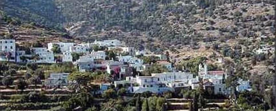
AGATHONISSI (Island) DODEKANISSOS
Agathonisi is the north most islet of the Dodecanese
island complex.
The coast configurations of the island are quite impressive. There
are many beautiful and windless bays as are: Hohlia, St. George, Poro and Maistro
as well as their small promontories.
The surface of the islet is comprised of rocky and barren hills. Areas
appropriate for agriculture are very few indeed. The vegetation cover is poor
and bushy. The tree cover is sparse and the varieties are mainly olive, carob,
almond, fig and prickly pear.
Fresh water springs do not exist except for a few wells with brackish
water. Water for the inhabitants is collected by way of rainwater cisterns that
are filled by water carrying tankers in times of drought.
The island of Agathonisi was named Yetousa in ancient times. According
to contemporary researches today's name is the result of an etymological mistake
from the plant from which the name is derived “Agathonisi”, i.e. Island
of the Thorns.
A few ancient relics that were found on the island allow us to surmise
that Yetousa was inhabited from ancient times.
The island was probably finally inhabited permanently in the middle
of the 19th century by settlers from Patmos and Fourni. There is a witness of
there being established on the island some five or six families in the year 1895.
Today the population of the island is 112 people. After the incorporation
of the Dodecanese to the
rest of Greece, the island fell
under the jurisdiction of the municipality of Patmos
of the province Kalymnos,
with the name of “Agathonisi” or Gadaros-“Donkey” (because
the shape of the island resembles a donkey galloping towards the river Maiandros).
In 1953 it became a separate community and has remained so until today.
The oldest settlement is Megalo
Chorio- “Big Village” with 80 inhabitants. The village has been
built in such a way so that it is not visible from the sea, thus protecting it
from pirates. Built in the same way and for the same reason is Mikro Chorio -"Small
Village" with 15 inhabitants. The third and newest settlement is St. George with
15 inhabitants and is found in the innermost part of the bay from which its name
is derived. Both the bay and the village were named under the church of St. George
found there which also happens to be the parish church of the island. There are
also five chapels built in various places on the island.
The quiet life on the island, the calm, the hospitality of the locals,
the cleanliness of the beaches and the fresh fish which a visitor is able to enjoy,
since the cooking is done according to traditional recipes, all make Agathonisi
an ideal place for those who wish for quiet holidays away from the hustle and
bustle of the main tourist routes.
Manolis Makris, ed.
This text (extract) is cited February 2004 from the Dodekanissos
Union of Municipalities & Communities pamphlet.
AGIOS ISSIDOROS (Village) RHODES
Tel: +30 22460 51260
Fax: +30 22460 51260
AGRIOLIVADI (Beach) PATMOS
Agriolivadi is approximately 1.5 km from Skala. It has a long sandy beach with small pebbles. Sun beds and water sports are available. It also has a taverna and a beach bar. Its mainly shallow waters make it ideal for toddlers and the water is warmer than in most other beaches around the island.
There are some nice little coves at the northern part of the beach which are accessible only by boat or you can rent paddle boats and paddle there but only in good weather because the currents do get strong as soon as you reach the end of the cove.
Agia Thekla (Saint Thekla) is a little island opposite the cove. It is named after the church that was built on it. There is also a nice beach at the rocky island for those who can paddle out to it.
AI MICHALIS (Settlement) SYROS
San Michalis is a small hamlet. Its inhabitants are mostly farmers who live there all through the summer, while, during winter, they only visit it occasionally to carry out certain jobs.


AMORGOS (Island) KYKLADES
Amorgos is a remarkably unspoiled island at the south-eastern edge
of the Cyclades group, where traditional customs are still inextricably interwoven
into a landscape as rich in beauty as in its history. Originally inhabited by
seafarers from Asia Minor in the 4th Century BC, the island now cradles a people
who enjoy a lifestyle that has been shaped by a varied and dramatic past. This
is a place that appears untouched by time, but where the inhabitants quietly preserve
one of the best kept secrets of the Aegean.
The length of the island is 33 kms and its width between 1,5 to 6
kms. There are three mountain peaks "Krikelos" (822m) to the north, "Profitis
Ilias" (699 metres) in the middle and "Korax" (607 metres) to the south-west.
The dramatic mountain scenery provides a fine backdrop to some excellent walking.
Meadows and areas for cultivation, can be found in the area of Aegiali
at the north, in Katapola
at the centre, and at Arkesini
the southern part of the island. There are two ports on the island: of Katapola,
and of Aegiali, where ferries, catamaran and hydrofoils call, connecting Amorgos
with the other islands and the main land.
...There are several beaches along the coast line. In Aegiali, the beach is long and sandy, and starts from the edge of the fishing village Ormos. "Levroso", "Psili Ammos" and "Hohlakas" are 15 min. walk from the port, and can also be reached by small boat on a regular schedule.
On the nearby small uninhabited island of Nikouria, there are two nice sandy beaches, where small boats cross people for swimming, from the bay of "Agios Pavlos".
...On the other steep side of Amorgos, bellow the Byzantyne Monastery
of Virgin Mary Chozoviotissa, the beach of Agia Anna, is famous for the clear
blue and turquoise waters. Going south, at the same side of the island, "Mourou
" beach is very popular to all for the clear waters, the dark thick sand and the
two caves where one can swim in. In Arkesini, "Kalotaritissa,"
"Kato Kambos" and "Paradisia"
beaches are some among others found at the South end of Amorgos. The island has
a population of about 1.800 which is found in the port of Katapola, in Chora,
the capital, up in the mountains overlooking the east coast, in the port of Aegiali,
in the three villages of Lagada,
Tholaria and Potamos
and in the small villages of South Amorgos: Vroutsi,
Arkesini, Kolofana.
AMORGOS (Village) AMORGOS
The Chora is - without doubt - one of the prettiest towns to be seen on the Cyclades. It stands nearly 400 metres above sea level with views of both the east and west coasts of Amorgos. Forty churches are dotted around the village and there are beautiful shaded squares and narrow lanes to wander around beneath the Venetian Castle. There are a few taverns in the village, which offer excellent food, and some cafes
ANAFI (Island) KYKLADES
Anafi is the at the southern side of the Assosciation, at the eastern
side of Santorini.
At the southern side of Anafi is located the small island called 'Anafopoula',
both visible from the eastern side of Santorini.
Anafi is one of the most beautiful islands in the Cyclades
as it has managed to keep its natural beauty untouched. Golden sandy beaches,
a dry climate and deep green waters make the island unique for all those who desire
a tranquil holiday in a clean natural environment, following a simple way of life
near the hospitable local people.
Although it is a small island, it has a rich history and mythology. It was first settled in the eighth century B.C. by Dorians. After A.D. 1207 it devolved to a succession of Frankish families, such as the Foscoli, the Gozzadini, the Crispi and the Posani. In 1537 the island was pillaged by Khayr ed-Din, the pirate also known as Barbarossa.
There are two stories to explain the origin of its name: One is related
to the myth of the Argonauts, according to which the Argonauts became endangered
by a terrible storm as they were returning from their expedition. Suddenly the
island appeared before them, and for this reason it was called Anafi ('appeared').
The other version is related to the lack of snakes on ('An-Ofis'= 'without snakes').
This text is cited Apr 2003 from the Development Association 21th Geographical Unit URL below, which contains image.
ANAFI (Village) KYKLADES
There is only one village on Anafi, which called Hora Anafis. It is built upon the ruins of a Venetian castle, with vaulted, dazzling white houses and narrow little stone-paved streets identical to those found in the Anafiotika area beneath the Athens Acropolis Anafi is two kilometres from the port of Nikolaos, to which it is connected by the only motorway of the island.
There are two other hamlets on the island, which are inhabit-ed during
the summer months only. These are the port of Ormos Ayios Nikolaos and the hamlet
of Kleisidi.
This text is cited Apr 2003 from the Development Association 21th Geographical Unit URL below, which contains images.
ANTIMACHIA (Small town) KOS
APOLAKIA (Village) NOTIA RODOS
Tel: +30 22440 61252
Fax: +30 22440 61385
At the village of Apolakkias with the white wash walls and red tiled
roofs and its graphical Greek taverns in the square where someone can see the
old church of Saint George. Near the Saint Marina you can find the foundations
of a castle of the Knights. At the position Mili you will find tooms from the
Mycenaean period and at the position Korkoelia Hellenistic. The dam that was built
near the village helps with the development of the agriculture of the area and
the rest of the island as well. At this dam you will find ducks, exotic birds,
fish, and various other wild life. A great place to go and visit, peaceful in
total natural surroundings.
APOLLONA (Village) RHODES
Tel: +30 22460 91009
Fax: +30 22460 91173
APOLLONIA (Small town) SIFNOS
Apollonia, also known as Stavri, has been the capital of Siphnos since
1836. It was the seat of the Siphnos Municipality (1836-1914) and of the Apollonia
District (1914-1998), and is presently the seat of the newly formed Siphnos Municipality
(1999).
The name Apollonia derives from Apollo, meaning a town dedicated to
the worship of the God Apollo. As for the derivation of its common name, Stavri,
which dates back to 1677, there are various possible interpretations: it could
derive from the male proper name Stavros; from Timios Stavros meaning Holy Cross
(there was a church of a holy cross in the vicinity); from its location literally
at the crossroads where all the main roads of the island meet; or from the crosswise
design of the town plan and houses.
Whatever the derivation of its common name, Apollonia is indeed situated
in the geographical center of the island and it is built amphitheatrically on
three hills. The island's commercial center, this is where you will find, among
other things, news agencies, travel offices, banks, stationary shops, as well
as the island's medical clinic, two pharmacies, the two police stations, the telecommunications
facilities sand gas stations. Apollonia has no shortage of restaurants, traditional
coffee houses, cafes, bars, and souvenir gift shops.
Visitors can stroll on Apollonia's stone-paved streets and lanes,
and enjoy the picturesque to local architecture, or have a drink or coffee at
the many coffee bars or sample the delicious local cuisine in one of the many
restaurants. To appreciate the local history and culture, a visit to the Folklore
Museum in Apollonia's central square is highly recommended.
Other sites of historical and cultural interest include the old schools
of Saint Artemios (1832-1988), the church of Saint Artemios (1629), which belongs
to the Simonopetry of Mount Athos, the Virgin Mary of Barou with the French frescoes
and wood curved temple the churches Saint Athanasios, Saint Sostis, the Transfiguration
of Christ, the Holy Cross and the Bearded Virgin ''Uraniofora'', the busts of
poet Rambaya in the square of the same name and that of Aristomenis Provelengios,
made by the famous Tinian sculptor Giannoulis Halepas, in the courtyard of the
Gymnasium.
South-west from Apollonia, on the highest peak of Mount Prophet Elias,
visitors can see the imposing monastery of the same name (1145-1890), where many
of the monks were iconographers; those who enjoy hiking will never forget the
panoramic view of the Aegean and the scenic way in which the island's many villages
punctuate the soft contours of the hills across from Mount Prophet Elias.
On the north slope of the same mountain, visitors can also see the
Monastery of Saint John tou Moungou (the Mute) (ca. 1650-1834), where Parthenios
Heretis, o monk well known for his intellectual and scholarly pursuits, lived
and worked.
ARCHIPOLI (Village) RHODES
Tel: +30 22460 98164, 98260
Fax: +30 22460 98164
ARGINONDA (Settlement) KALYMNOS
Little more than a beach, a few houses and two tavernas. Traditional, quiet, a
small haven of green between sea and mountains. Convenient base for hill walking
and rock climbing.
ARNADOS (Village) TINOS
Arnados, with its marble paved square, traditional houses and narrow streets, lies at 9 km from "Chora" on the slopes of Kechrovounio. The church of Analipsiou tou Sotiros dominates the centre. Traditional cafes and taverns abound.
ARNITHA (Village) NOTIA RODOS
Tel: +30 22440 61088
Fax: +30 22440 61088
In the village of Arnitha any visitor can take it easy under the big shady willow trees and from the eucalyptus trees and then visit the monastery of Saint Filimona with the old Christian design.
On the hill of old castle is traces of and old settlement and castle and Hellenistic graves. The old Christian baptistery which was found in the royal Byzantine church of Saint Irene was turned into a fountain and today is a jewel in the square of Argirokastro in the old town of Rhodes
ARTEMONAS (Village) SIFNOS
Tel: +30 22840 32388
Fax: +30 22840 31234
According to the local lore, the village was allegedly the place where
Artemis, The well-wisher, namely the goddess who protected those disembarking
from the arriving ships, but also the one who brought about favorable resolutions
to various troubles, was worshipped. Though this lore made for good stories, it
is highly unlikely that is historically accurate, for in ancient time places were
Artemis was worshipped were called Artemissia. According to a scholar the name
Artemonas, or Artemon, relies on the same linguistic structure as that of Parthenonas,
or Parthenon, which itself derives etymologically from Parthena meaning virgin,
virginity being one of the attributions of Artemis.
Artemonas is the birthplace of Nikolaos Chrysogelos, already mentioned
above, and of Ioannis Gryparis, a highly esteemed Greek poet and philologist.
A municipality in its own right from 1914 until 1998, Artemonas is now part of
the single Municipality of Siphnos. One and a half kilometers north of Apollonia,
Artemonas is one of the most picturesque villages of Siphnos, thanks to the neoclassical
architecture of many of its houses and its beautiful gardens.
Of the many windmills that used to stand at the top of the hill, today
only two are in good condition. This spot is worth a visit for its panoramic view
not only for the other villages, including Kastro, but also of the nearby islands.
In Artemonas visitors can see the house where the poet Gryparis was born, the
churches of the Virgin Mary of Kohi, for its interesting architecture, the Virgin
Mary of Samos, an extension to which was added in1788 and where you will find
the icon of the Virgin Mary, The Nun, a rare iconic depiction of Mary without
the Holy Child and the Virgin Mary of Balis, whose feast day is celebrated on
November 21.
ASKLIPIOS (Village) NOTIA RODOS
Tel: +30 22440 47064
Fax: +30 22440 47064
One of the old villages of Rhodes, Asclipio, still preserves the traditional Rhodian architecture. The village obtained its name from Asclipio who worked their in the ancient times. The Byzantine church of the village was built in 1060 on the ruins of an even older Christian church, the building is in a cross design. The walls have paintings from the 17th century. The small track leads to the rocky height were you will find the Byzantine Castle of the village. Asclipio has lately grown touristically, specially in the near by settlement of Kiotari, which is on the beach, where you will find luxury hotels, studios, apartments, and restaurants. Also, lately there are rent a cars, rent a motor bike, shops, bars, and water sports on the beach.
ASTYPALEA (Island) DODEKANISSOS
This most western of the Dodecanese
has had many names: Ichthyoessa (abundant in fish) in ancient times; Stampalia
or Astropalia, as the locals call it today. The name Astypalaia means "old city".
A mountainous island with an indented coastline concealing numerous
delightful coves, Astypalaia (or Astipalea) in fact resembles two islands joined
by a ribbon of land only 105 metres wide.
The main
village is Hora or Astypalaia,
built up the side of a steep hill, and presided over by the massive, austere remains
of a Venetian castle. Its small, square houses. painted white with brightly coloured
doors and windows. follow the contours of the hill in an almost unbroken band
down to the sea. So closely are they packed that the walls of the uppermost houses
form part of the outer fortifications of the castle.
A row of windmills on the pass of the hill provides an additional
picturesque note. One enters the castle from the southwest side of the hill Inside
it are two churches, dedicated to St. George and to the Annunciation (Evangelismos).
The former contains a noteworthy carved iconostasis.
Below the castle stands the 18th century church of Our Lady Portaitissa,
one of the most beautiful in the Dodecanese
It too has an impressive iconostasis, covered with gold leaf.
Livadia, Analipsi
and Vathi are charming fishing
hamlets on the south and north coast of the island, while among its many beaches,
Tria Marmara, Schinontas and Vathi stand out.
AVLONA (Settlement) KARPATHOS
The agricultural settlement of Avlona is situated to the north of
Olympus.
It has approximately 300 stables (farm buildings with threshing floors)
built on the eastern face of a fertile valley and is only subject to the winds
from the north.
(Text: Manolis Makris)
This text (extract) is cited February 2004 from the Dodekanissos
Union of Municipalities & Communities pamphlet.
AZOLIMNOS (Settlement) ERMOUPOLI
Leaving the village of Manna,
turning left, one reaches the village of Azolimnos.
It is right on the sea, and summer visitors enjoy its small and picturesque
bay. It offers a wonderful beach with many taverns, attracting both local and
foreign visitors.
CHROUSSA (Village) SYROS
Tel: +30 22810 61480
Chroussa, along with Pagos,
is a village situated in the centre of the island, at 7 km from Hermoupolis. It
is a typical agricultural site, among orchards and greenhouses. These supply the
island with fresh fruits and vegetables.
Its farms are built in traditional style and are typical of this kind
of architecture on Syros. One also finds some surprisingly grand country houses
in neoclassical style, dating from the 19th century and screened from the road
by pine groves. Amazingly green gardens thrive in the shade of these trees.
The impressive catholic church of Faneromenis is situated on the hill.
During religious holidays, it attracts a great number of worshippers. Remains
of an ancient settlement are found on the site of "Agia Thekla".
DAMATRIA (Village) RHODES
Tel: +30 22410 81388
Fax: +30 22410 81388
DIMYLIA (Village) RHODES
Tel: +30 22460 98218
Fax: +30 22460 98163
DIO CHORIA (Village) TINOS
The village lies at 8 km from the "Chora", on a wonderful site with
a view to match and plenty of fresh water. It boasts numerous traditional cafes
and taverns. A rather bumpy road leads out of the village to Lihnaftia,
where visitors will find a wonderful sandy coast with many taverns.
DODEKANISSOS (Island complex) GREECE
The Dodecanese or Dodecanisos is the name of the island complex in
the north eastern Aegean.
They are situated between the islands of Crete,
the Cyclades, Ikaria,
Samos and the Asia
Minor seaboard.
Apart from the twelve main islands, which gave the name to the island
complex (Rhodes, Astypalia,
Kalymnos, Karpathos,
Kasos, Kos,
Leros, Nisyros,
Patmos, Symi,
Tilos, Halki),
the islets of Lipsi (16 square
kms), Pserimos (14,6 square
kms), Agathonisi (13,4 square
kms), Saria (11 square kms),
Kastellorizo (9,1 square
kms), Levitha (9 square kms),
Giali (6 square kms), Kinaros
(4,3 square kms) amongst other islets, barren islets and rock peaks, all consitute
the group of islands known as the Dodecanese.
Sea shells and crustacean fossils which are found on top of mountains
indicate that the formation of this island chain, either wholly or partly, occurred
under the surface of the sea. During lengthy and complex geological upheavals,
dry land emerged only to be, to a great extent, resubmerged some 3-4 million years
ago, leaving only the mountain tops of “Aigaiida” above sea level
to form today’s Aegean
Islands.
The Dodecanese climate is of a transitional type and ranges from temperate
to dry tropical climates which is characterised with lots of sunlight and an extended
dry summer period.
(Text: Manolis Makris)
This text (extract) is cited February 2004 from the Dodekanissos
Union of Municipalities & Communities pamphlet.
EGIALI (Port) AMORGOS
Aegiali is an Amorgian small world consisted of its three traditional villages, Langada, Tholaria and Potamos climbing the slope of the highest mountain
on Amorgos, Krikellos (821). They are built above the deep valley and the harbor of Aegiali, which is a port with all the tourist services available. A beautiful sandy beach spans the gentle curve of the bay.
EMBORIOS (Settlement) KALYMNOS
Quaint, peaceful and set right at the end of the road - a real get away from it
all destination. Stay in an apartment or small house, enjoy a choice of three
quiet beaches with good snorkelling, stock up at the one mini-market or passing
mobile shops, eat in a choice of half a dozen tavernas. Good base for walking
or doing absolutely nothing and nice for small children.
FALATADOS (Village) TINOS
This mountainous village is situated at a distance of 10 km from "Chora". The famous "rozaki" grapes for the production of raki are grown here. The marble church of Agios Ioannis and the beautiful traditional Cycladic square of Megalocharis draw numerous visitors.
FANES (Village) RHODES
Tel: +30 22410 41492
Fax: +30 22410 41755
FINIKAS (Village) SYROS
Tel: +30 22810 42219
Finikas lies very near to Possidonia, at 11 km from Hermoupolis. Visitors
arriving by sea can berth in its harbour and eat in taverns on the seafront.
Tourists flock to Finikas during the summer. Rest, relaxation and
delightful walks along its coast are guaranteed.
Hotels and rooms for rent abound. The Community even boasts an Agricultural
health centre, with sport facilities such as basketball grounds. Children can
enjoy themselves in a safe playground created especially for them.
FOLEGANDROS (Island) KYKLADES
Folegandros lies between Milos
(15 nautical miles) and Sikinos
(five nautical miles). It is 102 nautical miles from Piraeus,
has an area of 32 sq. kilometres and a coastline 40 km long. Its population is
about 600. A mountainous, rocky island, its highest mountain is Ayios Eleftherios
(455 metres) in the south of the island, whilst the mountain of Merovigli in the
north is 312 metres high.
The historian Aratos called the island Sidira ('iron') because of
its rocky surface. Greek mythology says that the island was inhabited by shepherds
who came from western Greece in search of pasturelands. Because most of the shepherds
were men, the island was named Polyandros ('many men'). From this derives the
sailors' habit of calling the island Polykandro.
It was later settled by Cretans led by Folegandros, son of Minos,
who gave his name to the island. The next to arrive were Dorians, the last of
the island's colonists before it came under Athenian domination in the fifth century
B.C. Artemis and Apollo were worshipped on the island in ancient Greek times.
During the Roman period the island was used as a place of exile.
Under Venetian rule the islanders built a castle around the main village,
on the side facing the sea, so as to protect themselves from corsairs. During
the period of Prankish rule the island belonged to the duchy of Naxos.
In 1617 the island was captured by the Turks, ending Prankish control of the Cyclades.
Under Turkish rule Folegandros paid a tribute and in 1715 it suffered great pillaging
by Kapudan Pasha. After a short period of Russian control (1770-1774), the Revolution
of 1821 liberated the island from Ufa Turks and united it with Greece.
The largest village on Folegandros is Hora.
It is built on the edge of a great rock, 200 metres above sea level. In Hora there
is also an imposing stronghold consisting of houses, which begins in the middle
of the village and ends at the edge of the precipice above the sea.
This text is cited Apr 2003 from the Development Association 21th Geographical Unit URL below, which contains images.
GALISSAS (Village) SYROS
Tel: +30 22810 42408
Galissa, at 9 km from Ermoupolis, is a well-known seaside resort,
boasting the largest beach of the island. It counts modern hotel complexes, rooms
for rent and a camping.
The village is situated on a picturesque site. Its sandy beaches are
crowded by numerous visitors and its pier is a fine place for delightful strolls
and sightseeing. If you are romantically inclined, you can walk to the country
church of Agios Stefanos, built on the rocks just above the sea. The small snow-white
chapel of Agias Pakous (or Ipakous) was built on the foundations of an even older
church.
Remains of an ancient settlement were found here.
GENNADI (Village) NOTIA RODOS
GIALOS (Settlement) SYMI
In the right side of Gialos, a clock tower, named Roloi, built in
1881, counts for the Symiots the time which runs quietly in Symi.
In front of Roloi , Michalaki the little fisherman (made by Kostas
Valsamis) welcomes the ships, yachts and the caiques. The bell-tower of Evangelistria
looks like a true sentinel.
The Police, a remainder of the architecture from the years of the
Italian Occupation. In Tzi, there is a copy of the triemolia carved into a rock
of Acropolis of Lindus and an inscription written by the Dodecanesian Fotis Varelis
for the 8th of May. The Dove of Freedom by Kostas Valsamis. The Nautical Museum
of Symi with old maps, ship models, other exhibits from the maritime.
The Cathedral of Timios Prodromos, which was built in 1830 and refurbished
in 1869, with a marvelous pebbled yard.
This text is cited May 2005 from the Municipality of Symi URL below, which contains images
GRAMVOUSSA (Small island) AMORGOS
Gramvousa. A small island with sandy beaches across from Kalotaritissa beach on South Amorgos. Good fishing and snorkeling area. Is used as a resting spot for immigrating birds.
Grikos bay is situated southeast of the island. It is approximately 4.5 km from the port in Skala.
The road runs parallel to the coast making walking to and from Skala very beautiful and popular especially for joggers.
The bus stops by several times a day leaving you 50 meters from the beach.
Grikos is a popular settlement during summer because it is more quiet than most towns around the island especially during high season (august).
Its beach is the longest of the island with crystal clear waters and tamarisk trees for shade. Tragonissi (“ram island”) populated only by goats and a goat herder, faces the bay protecting it from bad weather (except SE winds) and making it perfect for yachts and boats to stop by or moor on the jetty that has a depth of 2 meters.
Most of Grikos has a view of Petra (or Kalikatsou as most locals know it) which is like a monument of Grikos.
HERAKLIA (Island) KYKLADES
Iraklia is the southern most island of the eastern small Cyclades.
Its small population is occupied with fishing, the cultivation of the earth, and
livestock. One road only links the two settlements of Ai Giorgi (St. George),
the port, and Panagia (our Lady), the town (Chora). The road and the footpath
that run through the middle of the island lead to the only sand beaches, the cave
of Ai Yhiannis (St. John), one of the most beautiful caves in Hellas, as well
as the Castro of Irakli (Hercoules).
This extract is cited May 2003 from the Iraklia
Association of Tourist Enterprises tourist pamphlet.
IOULIS (Small town) KEA
Ioulida is the largest town and the capital of the island. Only 5 km from the main port, it should be part of your itinerary. The inhabitants call it "Chora", but its correct name, used in its golden age, is Ioulis. It is a picturesque, typical Cycladic township with 600 inhabitants, a very interesting archeological museum, a prehistorical stone lion and a Venetian castle. Ioulis is well worth a visit. It is pleasant to stroll along its narrow streets.
ISTRIOS (Village) NOTIA RODOS
Tel: +30 22440 61249
Fax: +30 22440 61249
KALATHOS (Village) LINDOS
Tel: +30 22440 31604
Fax: +30 22440 31004
KALAVARDA (Village) RHODES
Tel: +30 22410 40024
Fax: +30 22410 40024
KALOTARITISSA BAY (Bay) AMORGOS
Kalotaritissa. A long sheltered sandy beach on the southern part of Amorgos, where many fishing boats and fishermen can be seen.
KALYMNOS (Town) DODEKANISSOS
The Capital of the island is "Pothia" with its colourful,
two storey houses and its traditional island character. The town has been built
amphitheatrically, with a population of 11.500 living in its densely constructed
neighbourhoods.
Its harbour, being well sheltered fro all winds, is considered one
of the most important island harbours in Greece
offering organized Marina services.
Various Municipal buildings were constructed by the Italians between
1930-35 in a Venetian style, and adorn the seafront along with a variety of shops
and cafes. There are countless churches displaying many valuable and beautiful
icons by various well-known Kalymnian artists.
In Pothia one can also find the local Archaeological
Museum, which is housed together with bequests made by Nikolaos Vouvalis,
a local benefactor. The recently set up Maritime
Museum as well as the Folk Art Museum containing exhibits from Kalymnian everyday
life and customs are both along the sea front road.
This text (extract) is cited November 2003 from the Municipality
of Kalymnos tourist pamphlet.
KAMBOS BEACH (Beach) PATMOS
Kato Kambos or Kambos beach is the most popular beach on the island, it is considered the place to be and be seen and is loved by families with young children for its shallow warm waters.
It is mainly a sandy beach with small pebbles. It offers taverns and cafes and is organized with sun beds, umbrellas and water sports.
There are also tamarisk trees for those who prefer natural shade.
The beach is exposed to S and SE winds but is still pleasant even when windy.
KAPARIA (Village) ANDROS
Tel: +30 22820 61469
Kapparia owes the name to the plant caper (kappari in greek), which
you will find everywhere. The village is situated at the higher point of the fertile
Korthi valley and from
here originates the river Kapparianos, which flows even during the summer.
Sights are the dotted pigeon houses (peristeriones), the water-mills
and the adjacent to the main village Megalo
Chorio, with excellent architecture.
Moving to the other side of the mountain you will find the serene
beach of Plaka, with crystal
clear waters, while on the main road don't miss a stop at Agios Georgios in Farali.
KARDAMENA (Small town) KOS
Tel: +30 22420 91208
Fax: +30 22420 91138
KARPATHOS (Island) DODEKANISSOS
This second largest island of the Dodecanese
chain, lies between Rhodes
and Crete. It is rather rectangular
in shape and its terrain is mountainous, the highest peak being Kali Limni at
1,214 metres above sea level. Most of its settlements are to be found on its south
coast, which is relatively flat. Near the north coast is a small island called
Saria, with which Karpathos
used to be united. On this islet, at the site called Palatia,
there are some ruins belonging to the ancient
town of Nisyros.
Karpathos’ capital and main port is Pigadia
or Karpathos on the southeast coast. It was built primarily with funds sent
home by immigrants to the United
States and it does not reflect the local architectural style found in the
older villages.
Southwest of the capital is Menetes,
whose history started after the Middle Ages, and Arkassa
which has been identified as the site of ancient
Arkesia. Here the ruins of a Christian Basilica of 5th/6th c. A.D can still
be seen.
Thirteen kilometres to the northwest, you come to Piles,
mountainous Othos to the
northeast with its folk art museum, and Volada,
a traditional village with houses whose interior decoration is well worth a look.
Further north, near the west coast, is Messohori,
where there is a genuine Karpathian house open to the public. Note its characteristic
wooden ornamentation and the pebble mosaic floor. Still further north, almost
cut off from the rest of the island, is its most important village, Olimbos,
which is accessible only from Diafani,
Karpathos’ second port.
Olimbos sits
on a hlllside overlooking the Aegean.
Founded sometime between the 10th and 15th century, it was originally fortified
to afford its residents protection from the pirates. The highest spot in the village
used to be crowned with a tower. Even today Olimbos
has preserved its local architecture intact, both in the interiors and exteriors
of the houses. Its citizens take pride in maintaining their traditions and still
speak a dialect which contains several Dorian words and idioms. Karpathos has
many beautiful beaches: Finiki
and Amfiarti to the southwest, Makriyialos to the southeast,
Agia Irini on the west coast and Agios
Nikolaos on the east.
KASSOS (Island) DODEKANISSOS
Kasos, the most southern of the Dodecanese,
is only 27 nautical miles northeast of Crete.
Its first inhabitants are thought to have been the Phoenicians. Homer mentions
it in his catalogue of the Greek cities that took part in the Trojan War.
Kasos is a mountainous island with a steep, rocky coastline and few
beaches. In the 18th century, kasos established its own merchant fleet and grew
rich from trade. It played an active role in the Greek War of Independence of
1821, earning the revenge of the TurkoEgyptian armada, which set fire to the island
in May 1824 and subsequently slaughtered its inhabitants. Only a few survived.
The capital of the island is Fri,
built on picturesque Bouka Bay. Its old stone houses- many of them constructed
by sea captains - extend on both sides down to the sea.
To the east and very near Fri
is Emborios, the island's
other coastal village. It boasts a beautiful church dedicated to the Nativity
of the Virgin. Other villages include Agia
Marina, set on a hill lust one kilometre southwest of Fri,
and Arvanitohori, southeast
of Agia Marina, nestled in the island's only valley. Two kilometres from Agia
Marina there is a cave called Sellai, 30 metres deep and 8 metres wide, with
impressive stalactites.
Swimmers will find pleasant beaches at Fri,
Emborios, Ammouda and on
the nearby islet of Armathia.
KATAPOLA (Village) AMORGOS
Katapola itself is busy with a waterfront lined with cafes, taverns and mini-markets and a shelter for sailing boats. On the hill above Katapola, the excavations of the ancient city of Minoa, are of significant value. At the head of the bay lies Rahidi, with the large church of St George and the village that lies behind it. The most picturesque part of Katapola is the third section called Xilokeratidi, with its pretty narrow streets and a couple of taverns where you can sit in the shade of large trees and enjoy the view.
KATAVIA (Village) NOTIA RODOS
Tel: +30 22440 91206
Fax: +30 22440 91206
KATO PETALI (Village) SIFNOS
Petali is the name of two villages, Kato Petali (Petali Below) and,
because on its location on the hill above, Pano Petali (Petali Above). In the
local dialect, Petali means stony height, and is a commonplace name on the island.
Kato Petali is east of Apollonia,
built at the foot and on the gentle slopes of a hill. The building that stands
out on this village is that of the church of Zoodochou Pigis (1894). To raise
funds for its maintenance and restoration, the villagers sing the Virgin Mary's
Carols on January the 1st, the same melody as the Christmas carols accompanied
by local instruments. Of great interest is the stone-covered courtyard of this
church, with its traditional design patterns, as well as the architecture of the
houses, the object of a study by the German academic Friedrich Wagner and his
students. The old building that used to house the old primary school (1924-1994)
now houses the Music School of Siphnos.
East, of Kato Petali, you will find the old monastery of Saint John
the Chrysostomos (Saint John with the Golden Tongue), which was founded in 1650;
according to local tradition, this was where the first Greek school on Siphnos
was located, and where, too, the School of the Holy Sepulcher, known as the Helleno-museum,
was housed before it was moved to the School building of Saint Artemios. South
of the village, in the middle of an olive grove, you will find the beautiful church
of the Virgin Mary of Koukia (1614), also known as Myrtidiotissa.
This text is cited August 2004 from the Municipality of Sifnos URL below, which contains images
KEA (Island) KYKLADES
This exceptionally picturesque island lies close to the south-east
coast of Attica.
The mountain masses, which are encountered in most of the Cyclades,
are broken up by small valleys sparsely planted with vines and fruit-trees and
run right down to the sea, opening out into pretty little bays. On the western
side of the island is Agios Nikolaos
bay, and deep within it the port of Korissia,
which is considered to be one of the safest natural harbours in the Mediterranean.
Ferry-boats call at Korissia
- also known as Livadi - which stands on the site of the city of Korissia,
which in ancient times, with Ioulis,
Karthea and Poiessa,
was one of the island's four independent city-states.
The island's capital, Hora
or Ioulida (6 km. from Korissia),
has maintained its Cycladic idiom intact. Built in the shape of an amphitheatre,
it presents the visitor with an impressive vista of two-storey houses and tiled
roofs, steep cobbled alleyways and splendid churches with elaborately carved wooden
icon screens. At the highest point of the village, on the site of the ancient
acropolis, is a quarter known as Kastro which commands a breathtaking view of
the nearby islands off the coast of Attica.
Not far from here is the famous "Lion of Kea" (6th century BC), hewn
out of the slate.
The Archaeological
Museum in Hora contains interesting finds dating from the Cycladic period.
The interior of the island is dotted with miniature chapels, windmills and monasteries,
including that of Our Lady Kastriani, Kea's patron Saint. Easilly accessible from
Athens, Kea offers those who
are seeking a restful holiday clean, uncrowded beaches at Pisses,
Korissia, Koundouros,
Otzia bay and Poles bay.Here
they can enjoy delicious fresh fish at picturesque little tavernas.
This text is cited Apr 2003 from the University of Patras' XENIOS DIAS website URL below, which contains images.
KEFALOS (Small town) KOS
Tel: +30 22420 71112, 71208, 71560
Fax: +30 22420 71337, 71560
KINI (Settlement) SYROS
Leaving Galissa,
a short cut leads to Danakos
and to Kini, a lovely fishing
village where a special kind of magic is created, each evening, by the glowing
colours of the sunset. It is, without a doubt, your best choice for family vacations.
The view on the village is spectacular. Sunlight sparkles off the
white houses dotted along the bay, where small fishing boats float on the calm
and deep blue surface of the sea, with the hills of Pano Meria as a perfect backdrop.
The beaches of Kini and Lotos,
as well as that of the bay of Delfini
are among the most pristine on the island, with plenty of taverns and hotels nearby.
This text is cited Apr 2003 from the University of Patras' XENIOS DIAS website URL below, which contains image.
KOCHYLOS (Village) ANDROS
Tel: +30 22820 61046
Hanging on the mountain, Kochylou, a real artist's painting, awaits
you to visit the neighbouring Kastro Faneromenis (Faneromeni Castle) and to refresh
you with a magnificent view of the Aegean
Sea.
Take a delightful walk in the twisting stonepaths of the village,
making a necesary stop for a rest at the coffee-shops. The village area has picturesque
springs and beaches, such as Melissa and Lavantara with its caves and access from
the sea and isolated Bouros with access from Ormos,on foot. It is worthwhile to
walk towards Ormos through
the well-maintained path, finding out in this way that the village is not so mountainous
as it seems.
KORISSIA (Village) KEA
As the ship turns to starboard, the small township of Livadi slowly unfolds itself, with its pier, anchorage and blindingly white houses with their red tiled roofs huddling at the foot of the hill. Upon disembarking, the visitor will only get a fleeting impression of a port backdropped by hills. He will then discover that most of the scenic beauty of the island is hidden among those hills: charming sites, including Agia Triada and Agios Savvas are well worth a visit. Today, Livadi offers every comfort to visitors, from hotels, rooms to let, restaurants, coffee-shops, bars, souvenir shops and modern supermarkets.
Fishing boats and yachts make a pretty picture at the port's small quay. At the northern end of the port, one finds the parish church of Agia Triada. Its name day is celebrated in an exceptional manner throughout Livadi and the surrounding countryside. Traditionally, cows were kept, mainly for the daily consumption of fresh milk. No cheese was produced.
KORTHI (Village) ANDROS
Tel: +30 22820 61354
Korthi is a vast area in the south part of the Municipality, which
includes many villages. Many places are worthwhile seeing.
Aidonia
is a picturesque village, with a nice old spring, the castle-houses (pirgospita)
and Alinou Monastery. You will never forget the festivities (panigiri) in Kournous
high above Aidonia, on August 29th.
Visit the traditional village Amonakliou
and medieval Mousionas,
Agia Triada in Korhi, which was the first school in Andros established before
the War of Greek Independence and it has remarkable relics. In Piso
Meria you can see the water-mills in Bouro. Have a rest at the scenic square
in Korthi and move on to the byzantine churches of Agios Ioannis Theologos and
Agios Nikolaos.
If you feel adventurous you can go to Steno area, where you will compensate
with the view and the isolated sandy beaches you will find.
Don't forget to take a look at Moni
Tromarchion and to be present in one of the festivities taking place there
in easter and mid-August, and also in Agios Ioannis in Kremmydes at the end of
September, where you will go by a fishing-boat.
KRITINIA (Village) RHODES
Tel: +30 22460 31270
Fax: +30 22460 31270
KYPEROUSSA (Settlement) SYROS
Kiperousa is a small rural community. Its inhabitants are mainly farmers who live there all through the summer, while only paying it an occasional visit in winter to carry out certain jobs.
LACHANIA (Village) NOTIA RODOS
Tel: +30 22440 46051
Fax: +30 22440 46051
LAERMA (Village) LINDOS
Tel: +30 22440 61493
Fax: +30 22440 61493
LAGKADA (Village) AMORGOS
Langada is located at the end of the valley in an idyllic location among steep rocky peaks and deep valleys. It is quite easy to reach the port from here on foot or by a car. There are exciting sights to be discovered while hiking or walking on the numerous trails of the area. The gorge of Araklos, the historical church of Agia Triada, the old church of Panagia Epanohoriani, the half-ruined settlement of Stroumbos and the exceptional beauty of the natural landscape can be admired.
Within one hour's walk from Langada one can see the unique Byzantine monument of Theologos, a monastery of early Byzantine years. A bit further, the historical little chapel of Stavros is situated. In most of these locations traditional festivals take place every year, in memory of the patron saints, and many people from the island participate in the celebrations.
Lambi is renowned for its rare multicolored pebbles. There used to be hills of them but the pebbles are so beautiful it is hard to resist making a collection of them which means hills have been flattened out.
The word Lambi means shining and is derived from the sun reflecting against the beautiful stones and the clear waters of the bay.
The beach is long and has tamarisk shrubs for shade. It can be reached by turning left at the junction after Kambos beach. If walking it takes around 25 minutes from Kambos Beach.
There are usually boats (caiques) that leave from Skala around 10AM and take about an hour. Being on the north side of the island it is open to meltemi winds so boats are not always available for this location.
It's also a pleasant location for lunch and dinner. The taverns are on the beach and serve food in a peaceful atmosphere.
There are also the remains of the old settlement Platys Gialos and the church of the Transformation (Metamorphosis) which is from the 16th century and considered as one of the most important sanctuaries of the island.
LARDOS (Village) RHODES
Tel: +30 22440 44251
Fax: +30 22440 44470
LEFKES (Village) PAROS
Tel: +30 22840 41990, 41617
Fax: +30 22840 41990
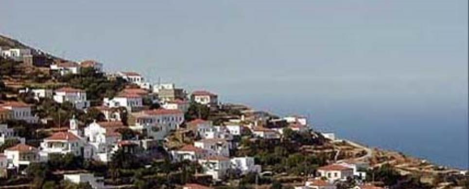
LEROS (Island) DODEKANISSOS
Situated between Patmos
and Kalimnos. Leros is an
island of small fertile valleys sandwiched between rolling green hills, deep coves
and pretty beaches Leros’ topography has given rise to many villages. The
most important is the capital. Agia
Marina - united with two other villages. Platanos
and Pandeli, on the back
side of the hill - a collection of little white houses, neoclassical buildings
and narrow alleyways It starts at the seaside and gradually climbs up the sides
of the hill, whose summit is dominated by the sombre remains of a Byzantine castle.
Of special significance during Byzantine times, its shape is that given it by
the Knights of St. John, who arrived in Leros in the 14th century. Still standing
today are the circuit wall and the church of Our Lady within it L.aki, 3 kilometres
south of Agia Marina is the
islands port. It is built at the back of a deep, practically enclosed bay, whose
mouth is only 500 metres wide This is one of the largest and best natural harbours
in the Mediterranean Alinda,
Xirokambos, and Partheni
are charming seaside villages, while you'll find wonderful swimming at the beaches
of Agia Marina, Pandeli,
Vromolitho, Alinda,
Laki, Merikia,
and Xirokambos, to name a
few.
LINDOS (Small town) RHODES
Lindos stands on the eastern side of the island, at a distance of
55 km from Rhodes town. According to tradition, it was founded by Lindos, brother
of Kamiros and Ialysos. There were links between the culture of the ancient city
and that of Mycenae, on which it seems to have exerted an influence. Lindos soon
developed into an important commercial and shipping centre (between 8th and the
6th centuries BC), and it founded colonies throughout the Mediterranean basin.
The city also made advances in the arts and letters. Cleobulos, on of the Seven
Sages of ancient Greece, the poet Peisinus and the sculptor Chares, who created
the famous Colossus of Rhodes, were all Lindians. The city continued to flourish
through the Middle Ages, and was important in the manufacture of pottery, embroidery
and woven goods. It was taken by the Knights of St. John and later by the Turks.
From its long history, there are many traces to admire today. The most important
monuments are to by found on the acropolis, where we can see the trireme carved
in the rock, the colonnade of the temple of Lindian Athena, the Propylum and the
temple itself. The temple once contained picture by the most famous painters of
antiquity: Zeuxes, Apelles and Parrasius. The VII Ode of Pindar, in praise of
the athletic triumphs of the Olympic victor Diagoras, was carved on the temple
marbles. Of the monuments below the acropolis, the most important are the Tomb
of Cleobulus, the Theatre and the Tomb of Archocrates. The village mansions are
of great interest, as is the church of Our Lady.
On the coast near Lindos is the little bay of St. Paul, where according
to tradition the Evangelist landed when he arrived in Rhodes to spread the new
religion.
This text is cited June 2003 from the Rhodes
Hoteliers' Association tourist pamphlet.
LIPSI (Island complex) DODEKANISSOS
Not far from Patmos
is a group of tiny islands, known collectively as Lipsi. They cluster round the
largest. the onry one which is inhabited. Lipso or Lipsi.
Here you will find beautiful sandy beaches and translucent waters.
The island is so small that you can go everywhere you want to on foot. The hamlet
on the protected natural harbour is composed of spotless whitewashed houses, while
its mini-piazza boasts tavernas, ouzeri, cafes and other eateries.
LIPSI (Island) DODEKANISSOS
Geographical position:
Lipsi are a cluster of islets in the southeastern Aegean and are
found north of Leros and
east of Patmos. Their collective
name is taken from the name of the largest island Lipsi or Lipso, which is comprised
of two landmasses, joined together by a narrow 400m. wide neck. The total area
of the cluster is 17.3 square km. The name of Lipsi is a very ancient one. With
the form of the name "Lipsia" it is encountered on ancient inscriptions.
Geophysical description:
The landscape of the island is comprised of low hills (the maximum
height, in the northwestern part of the island, being no more than 277m. above
sea level) and small fertile valleys. Picturesque bays (Lipsi, Fontana,
Moschato, Limni, Tarsanas, Platys
Gialos and Liendou), interrupt at intervals the rocky and precipitous coastline.
Around the main island, 24 islets and 6 rocky peaks make up an impressive island
group or "polynesia".
History- Monuments:
The history of Lipsi is inseparable from the history of a larger
neighboring islands and especially that of Patmos. As were all the islands of
the Dodecanese, Lipsi seems to have been inhabited continuously from pre-historic
times until now. Inscriptions and clay pots dating from classical times were found
in various parts of the island. Lipsi's neighborhood with Patmos leads us to believe
that Christianity was brought to the island as early as the first century AD.
The monuments belonging to the early Christian period are of importance. These
are: a large three-chambered basilica with mosaic flooring and a baptistery, probably
of the 5th century, situated at "Kouselio", remnants of walls, architectural remains
and mosaic floors at "Katsadia". Today the churches of St. Spyridon and St. Panteleimon
are also located at Katsadia.
Activities:
At the turn of the century the inhabitants numbered some 200 persons.
Today Lipsi has 606 persons, although during the summer season the population
increases dramatically due to the visitations of emigrants returning from the
U.S.A., Canada, and Australia, Germany, Attica
and Rhodes and because
of, the tourists, both foreigners and Greeks alike. The locals are occupied with
agriculture, animal farming and fishing. All the local products are of exceptional
quality. In the south of the island are wineries, which produce the delicious
local black wine. The main activity however is tourism, infrastructure for which
is satisfactory and is continuously being upgraded. Water is in short supply,
however recent works including the sinking of wells, construction of a reservoir
and a new water supply network meet the needs of the local and visitors.
Settlements-Administration:
The settlement of Lipsi
is situated roughly at the center of the island, deep along the windless bay of
the same name. The public services available are a transient police station, customs
house, pre-school, primary school, high school and a senior high school. Other
settlements are: Kouselio, Katsadia,
Panagia of Charou and Platys
Gialos. Today the island of Lipsi, together with the surrounding islets, constituted
the municipality of Lipsi, which is under the administrative jurisdiction of the
province of Kalymnos.
Sites:
Lipsi are an ideal place for anyone who wishes to spend their holidays
peacefully, away from the urban centers and to enjoy the sun, and the company
of simple folk. There are many very beautiful beaches on the island: Liendou is
a favorite due to its proximity to the main settlement, Kambo, Platy Gialos, Katsadia
are Located in the south of island, Papandria, Hohlakoura,
Tourkomnima, Xirokambos, Monodentro
and Kamares are found in the north. The colorful town of Lipsi, with the white-washed
houses and blue shutters, preserves its island character. In the main square of
the town visitors will find taverns and cafeterias offering their fine local foodstuffs
and beverages. At the center of the town, north of the church dedicated to St.
John the Theologian, is situated (in a ground floor hall) the archaeological collection
of Lipsi. There the visitor will view exhibits of findings of clay pot pieces
and inscriptions both on tablets and columns, which are dated from the classical,
Hellenistic and Christian periods. It is worth the trouble to visit the picturesque
Panagia of Charou, which was built early in the 17th century and the surrounding
islets-daily excursions and boat trips are organized - and walk along the paths,
which criss-cross the island and direct the nature lover to idyllic places.
Traditional Foods, Sweets, Beverages
Foods: cheese pie, lentil keftedes, kouloures (rye and wheat, kneaded seven
times), kalamari (rerved with dark rice or stuffed), mezithra cheese, pan-fried
pies, cheese in oil or brine, spinialo, goat with potatoes or pasta, olives (black,
green), olive oil (made from koronaikes olives and of exceptional quality).
Sweets: pougkaki (fried or oven baked), xerotigano or dipla, moustalvria-petimezi
(made from grape syrup). Thyme honey, dried figs, syrupy fruits (tomato, grape,
quince).
Beverages: Fokiako sweet black wines, white wine or black which can be
semisweet or dry (it is the private produce of individual wineries).
This text is cited December 2002 from a tourist brochure of the Municipality
of Lipsi
LIVADI (Settlement) FOLEGANDROS
Livadaki is the only part of the island which is not rocky, with a
spacious, clean beach. Most of the island's produce, such as figs, olives, tomatoes,
vegetables, etc., comes from this region and from Ano Meria.
This text is cited Apr 2003 from the Development Association 21th Geographical Unit URL below, which contains images.
LIVADI DELAPOTHITOU (Beach) PATMOS
This picturesque bay has become one of the most popular beaches on the island. It's a sandy beach with some small pebbles. Τhe water is almost always calm due to the protection offered by the facing island of Agios Giorgios (St.George) named after the small church that's on it.
The island is at a swimming distance with a small sandy beach that awaits you, but there is usually a draft and some extra effort is needed at some points (not recommended for the unfit).
It's 12 kilometres from Skala and about a 35 minute walk from the bus station on Kambos beach. To get there you take a right at the junction at the end of Kambos beach and go up the hill. Turn left at the top of the hill and after about 3 kilometres to your right is the down hill asphalt road that takes you to the beach.
There is a tavern there that supplies you with your basic needs.
LYGERO (Settlement) SYROS
Ligero is one of the island's many hamlets, where the inhabitants are mostly farmers. It is typical for this type of agricultural community that is is inhabited throughout the entire summer, but only occasionally in winter, for the necessary chores.
MALONAS (Village) RHODES
Tel: +30 22440 51297
Fax: +30 22440 51297
MANA (Village) SYROS
Tel: +30 22810 88601
A Mediterranean village, 3 km from Hermoupolis, among green valleys
and farmland, spreading to the beach of Azolimnos. The village is surrounded by
greenhouses, producing fresh vegetables. Parts of arable fields are divided by
cane-plantations.
You pass by it on your way to the Airport.
MARITSA (Village) RHODES
Tel: +30 22410 47600
Fax: +30 22410 47184
MARPISSA (Village) PAROS
Tel: +30 22840 41217
Fax: +30 22840 41744
MASSARI (Village) RHODES
Tel: +30 22440 51283
Fax: +30 22440 51283
MASSOURI (Settlement) KALYMNOS
A lively, friendly resort set along the tree-lined coast road and a popular base
for families and climbers. The wide sand and shingle beach is great for sunbathing,
swimming and water sports. Plenty of places to stroll, shop and eat until late
at night, some stylish bars, two internet cafes and a few clubs - all used by
locals as well as visitors. A wide choice here of hotels and apartments - most
with sea views.
This text is cited Febr 2004 from the Municipality of Kalymnos URL below.
MAVRI RACHI (Settlement) SYROS
Mavri Rahi is a small hamlet. Its inhabitants mostly consist of farmers who are there all through the summer but only rarely in winter.
MEGAS GYALOS (Village) SYROS
This is a resort with quite a few hotels, rooms for rent and the attraction
of a beautiful coast with a crystal-clear, turquoise sea.
The small pier is dominated by the picturesque chapel of Agios
Antonios.
MEGISTI (KASTELORIZO) (Island) DODEKANISSOS
Megisti (or Kastellorizo) is the Aegean’s easternmost island.
It has been inhabited since prehistoric times. The Dorians who settled it later
constructed fortified acropolises near the present day town and at Palaiokastro,
where some ruins can still be seen. The name Kastellorizo comes from its castle,
Castello Rosso (or red castle), erected by the Knights of St. John.
The island’s only settlement
is Megisti, otherwise known
as Kastellorizo, on the northeast coast. Its houses line the horseshoe - shaped
port and climb up the foothills of the mountain behind it. The top of the mountain
is crowned by the aforementioned castle, where Lambros Katsonis fought the Turks
in 1788. The gracious two-storey neoclassical houses with their brightly painted
doors and windows, wooden balconies and tile roots on the waterfront and the majestic
domes of the churches, testify to the island’s former prosperity. A photograph
in the Archaeological
Museum will show you how many hundreds of houses there used to be. Most of
them were destroyed by World War II bombs.
Though there are no beaches as such on the island, you can take a
little boat to the particularly beautiful blue grotto of Parasta, and there is
excellent swimming from the rocks near the port. Boats are also on hand to take
you to the nearby islets of Ro
(6 n.mi. west) and Strongili
(5 n.mi. southeast). Both islands have wonderful beaches. Ro
became famous when its sole inhabitant, the lady of Ro, used to raise the Greek
flag there every morning.
MELITSAHAS (Settlement) KALYMNOS
Small natural cove with a sand and shingle beach facing west. A real suntrap by
day and very quiet in the evening, with just one beach taverna. The road from
Myrties is not long but it is hilly. Worth the effort, though, especially as it
passes the picturesque harbour of Melitsahas, which is full of fishing boats and
activity around them. No wonder the couple of tavernas here specialise in fish!
This text is cited Febr 2004 from the Municipality of Kalymnos URL below.
Meloi beach is one of the closest beaches to the port of Skala.
Being only 2km away, it’s a 15-minute walk making it very popular with people who have no transportation. It’s a sandy beach with tamarisk trees for shade.
The islands camping site is only 20 meters away from the beach offering a popular restaurant and a mini market.
There is also a traditional Greek tavern and a dock for shallow mooring.
MESSANAGROS (Village) NOTIA RODOS
Tel: +30 22440 46096
Fax: +30 22440 46096
MESSOCHORI (Village) KARPATHOS
Tel: +30 22450 71212
MINOA (Ancient city) AMORGOS
The Ancient site of Minoa, at Moundoulia Hill, above the port of Katapola,
was one of the most important centers of human life and activity on the island
throughout prehistoric times. Enormous excavation project reveals evidence that
the whole site of ancient Minoa was constantly populated at a high cultural level
from the 10th century B.C. to the 4th century A.D. The defensive wall from the
Geometric period with its extensions and bastions which surrounded the acropolis
can be made out. The long 4th century B.C. Gymnasium building dominates the archaeological
site. The foundation of a sanctuary from the Geometric period have been preserved
at the peak of the acropolis. The Hellenistic temple on the far left, surrounded
by smaller buildings of worship is impressive with the body of a statue standing
alone in the middle. A characteristic building on the south side of the Gymnasium
site is the lavatory which has been preserved almost intact with its duct cut
into the rock..

Receive our daily Newsletter with all the latest updates on the Greek Travel industry.
Subscribe now!
