Listed 24 sub titles with search on: Main pages for wider area of: "TRIKALA Province THESSALIA" .
AETOS (Settlement) TRIKALA
The elders remember it with the name Dovroi which means "fine place".
The distance from the national road of Trikala
- Arta until the
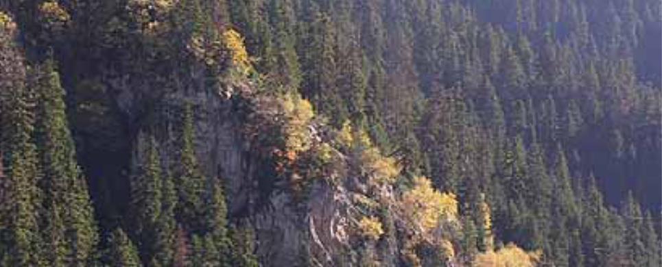
today's village is small and its altitude reaches the 700 m. Northwards and eastwards
is surrounded by tall, steep and rocky mountains.
Westwards there is the long ridge which begins from the Stayros mountain,
comes down steeply to the location of Paliokoromylia and continues downhill till
the Mill of the Kokkinos torrent. Southerly of the passage the plain land of Loggas
is shaped.
Benchmark of the village's communal life is the paving, capacious,
central square with the traditional cafe and the historical churches of Panagia
and Agia Paraskevi. At the entrance of the village there is the stone school,
which however today due to the lack of students remains closed. The few permanent
residents are occupied mostly with the cattle-breeding and occasionally with the
fishing and hunting. However, during the summertime everything lives up and at
the revelry of Agia Paraskevi for two days the village celebrates and the celebrators
revive the traditional customs of the region.
This text is cited September 2004 from the Community of Neraida URL below, which contains image
AGIOS NIKOLAOS (Village) ELATI
AGIOS PROKOPIOS (Village) TRIKALA
Agios Prokopios is a small community of cattle-breeders (100 inhabitants
in the winter and 250 during summertime) in an altitude of 620 m. in the wooded
slopes of Koziakas, among the crowns Drampala (1.298 m.), Dimitraki (1.300 m.)
and Diamandi (1.680 m.) under the famous homonymous monastery and above the dam
of the river Dramizioti, with the watermill of the 1880 next to it. From the top
of Drampala, we face the lake of Plastiras, the Thessalian plain and the castle
of Fanari.
In the sources Tzjom, Mana, Fteri, Kanalako, Megakampo and Pergina
of Padi plateau, are often seen roe deers, wolves, foxes, ferrets and some time
bears.
From the big monastery of Agios Prokopios of the 18th century, which
was extended in an area of 48 acres above the village, the only thing that remained
afterwards its demolition in 1960, is ruins. In 1986 the temple of Ag. Prokopios
went up from pedestals. Along with Agjos Prokopios, the name of a Saint is connected,
Kosmas the Aitolos and that of a thief, Gioulas. The village celebrates the memory
of Agios Prokopios on July 8, with dixies and folk revelry that follow the service.
AGIOS VISSARION (Village) TRIKALA
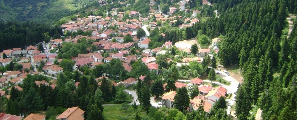
In the historical community of Agiou Vissariona (230 m. el.) we arrive
either by following the street that leads to that from Filyra,
through a most beautiful meadow, or from the side of Pyli's
that is hardly two kilometres far. The village owes his old name "Dousiko" in
an endemic of the place species of oak with the (slavic) name Dousko or Douskari.
The first resident of the village appears registered in the community's
male records since 1832, when it was under Douskar's courthouse. Dousiko,
built near the Portaikos river, has very healthy climate, which its 1.100 residents
enjoy (in the winter - they are increased to 1280 in the summertime), farmers
and cattle-breeders, but also "petrades" (builders of the stone) - and
along with them the seasonal visitors. In a small distance from the village is
found the forest "Lakka of Stefani's" and the breeding area of preys
of Koziaka.
The nearest crowns of Koziaka
are Krania (1.100 m.) and Fourketsa (500 m.). A watermill, Nizeros, is saved 2
km from the village as well as the fountains Psilles Vrises, Giannaki Vrisi and
Gabriel Vrisi. The latter is connected with the village with an old path, in all
the length of which one meets stone manufactures. Beautiful area for relaxation,
where the residents go at the 1st of May, is the meadow Dara.
The village was connected with the famous abbey of the Savior of the
Big Pylon, which is found in a distance of 5 km from there, going up in altitude
of 750 m. in the Koziaka's slopes. The monastery was re-established between 1527
- 1535 by Agjos Vissarionas, Larissa's
archbishop, when the Saint was exarch of Stagon.
In the place of the church that Agjos Vissarionas built with the help
of his brother Ignatios, it was built on pedestals in 1557 the today's catholic
of the abbey from Larissa's Metropolite Neofyto the 2nd and the bishops of Dimitriados
Joseph, Litza Louka and Torch Torture (as the ktitoric sign witnesses). The catholic,
which is honoured in the name of Metamorphosis of the Savior, follows the mount
athos type of cruciate four - pillar, with two (today) domes and slots in its
northern and southern side. Its hagiography was done by a painter from Constantinople,
Georgy. The woodcut temple is ulterior, in 1813. The once rich monastery with
the 365 cells and the rich library, which became an intellectual centre of the
newer Hellenism, functions today with few monks that look after its heirlooms.
Among them are also the saint's scull, the will with his autographic signature,
the stick and the vestments of Agios Vissarionas.
The grave of the Saint is saved in the Community cemetery, while in
the village the local show the place of his house and the monastery dependency
of the abbey. In 1823 the monastery was destroyed and the 2000 volumes of its
library were burned by the Albanians of P. Kortzia. In 1943 the monastery suffered
new destructions from a fire. Agjos Vissarionas celebrates in the feast of Saint
Spirit and in the memory of the Saint from whom it took its current name, on 14
September. In Agiou Vissariona's Eve the residents of the village go up in the
monastery for adoration and spend all night there for the celebration of the Saint.
ARMATOLIKO (Village) TRIKALA
Just after Mesohora
we find ourselves at the boundaries of the extended community of Neraida. We scramble
on the slopes of the SW mountain range of Pindos
form a rather good road and in an altitude of 850 m, the first village is distinguished,
Armatoliko. Its old naming was Mpoukouro or Mpokori which in Turk means "beautiful
place", in Rumanian "Shepherd's village" and in Slavic "vociferous place" from
the din of Acheloos.
The old village, built on the location Ampelia, was destroyed probably
during the 12th century from the Crusaders. Other reasons of destruction were
the raids of the Slavs or the earthquakes. During the Ottoman domination individuals
or groups that were on the run by the Turks, left Thessaly - Epirus - Aitoloakarnania
and found shelter in the today's village.
Today Armatoliko, near the National road of Trikala
- Arta, is a live
village that is inhabited both in winter and summer and where Primary School works
the whole year time. The village has respective prospects of development as through
the whole length will be washed by the waters of the lake, which will be formed
by the dam of the area. Among the sights of the village, besides the unique view,
is the small church of Agios Athanasios.
There are five more churches: Panagia, Agios Konstantinos, Agioi Pantes,
Agios Fanourios and the big church of Agios Georgios in the square of the village.
This square is spacious and with great view, cafes, playground. Near the square
there is the watermill which was transferred there afterwards the construction
of the pre-dam and the level rising of Acheloos.
Every year at the village, are celebrated traditionally the standard
revelries on the 15th of August, the day of the Easter and a small event on the
name day of Agios Athanasios.
DROSSOCHORI (Village) TRIKALA
KORYFI (Village) TRIKALA
Koryfi is the last village of the Prefecture of Trikala
to Arta. It is
surrounded by the steep, rocky mountains Kaprovouni and Katafyli and is built
amphitheatrically. The lowest edge of the village is defined by Acheloos. The
old denomination of the village was Kaproi and was first inhabited after the sortie
of Mesologgy from
the armed and thieves that were on the run. So, the first inhabitants of the village
were the "Mpotsareoi", who were forced to change their name because they were
wanted.
Koryfi was the seat of the thief Thymios Tsekouras who acted there
from 1895 until 1920. The village was destroyed from the earthquake and was reconstructed
with new buildings, roads, squares and shops. The traditional color of the village
is preserved by the "Dristella" which is found in the bed of Acheloos
and the historical watermill as well as by many stone fountains in different places
of the village.
Koryfi is inhabited in the winter as well and has taken new life as
the residents are occupied not only with cattle-breeding, but other works as well.
The big church of the village is Agios Georgios, but Koryfi celebrates when a
small country church celebrates which is devoted to the Assumption.
KOTRONI (Village) TRIKALA
In an altitude of 750m on the slopes of Kozjakas,
14km from Pyli,
there is the village of Kotroni with roughly 520 residents population. The settlement
Loggjes comes under
it, in an altitude of 300m with a population of 140 residents. The main occupation
of the residents is the livestock-farming. In the region there are the sources
of Koziakas Krania, Kagelja and Mana, as well as the tops Ai Ljas with 1600m altitude,
Leykes and Paliomantri with 1500m altitude, from where the whole Thessalian plain
is visible. In the biotopes Omprava and Paliomantri, the fauna is rich in roe
deers, wolves, woodcocks, partridges etc. Buildings of the previous century (1860,
1830) constitute special samples of the architecture of the region. The village
celebrates at the feast of Agia Paraskevi (25-26-27/7) with a three-day revelry
with local foods and in September 7 and 8 (The Birth of Virgin Mary) with revelry
in the square of the village and local flavours.
The settlement Loggjes celebrates on 20-21 May (Agios konstantinos
and Helen) Impressive is the traditional ceremony, the "paschaliogiorta",
the 2nd or 3rd day of Easter, in the church of Prophet Helias, at which phonetic
group of old men and women of the village, sing traditional songs that are danced
with special dances. In the region Krania and Bey a shelter is built, which the
visitor can reach with the paths through firs.
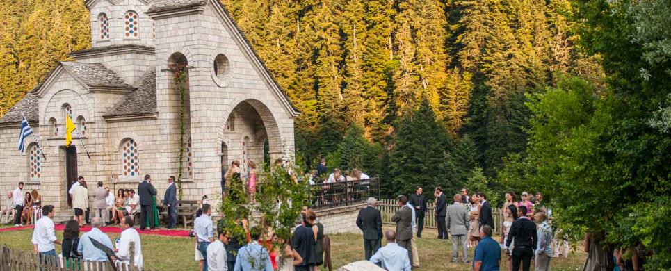
LAFINA (Settlement) TRIKALA
Lafina is built in altitude of 790 metres on the verdurous side of
Pindos that begins
from the mountain Kanalos and ends in the heart of Aspropotamos. It is surrounded
by Tzoumerka, for which numerous songs have been written and the white Kostilata.
The older name of village was Siliseno, that is to say slippery place.
Today Lafina discerns for the stone - made houses that were worked
from famous craftsmen and which, even if they went through the maelstrom of wars
and earthquakes (1967), have maintained their traditional colour to a large extent.
In the central square of the village next to the church and the traditional
cafes, dominates a perennial oak. In its shade the residents are gathered on daily
basis and on feasts. They discuss, celebrate, but also dance in the big revelry
of the village on August 6, when the historical county church of Metamorphosis
of the Saviour celebrates.
Unfortunately, in the winter the village depopulates and the recently
renovated Primary school does not function. Its residents however, wherever they
are, have sweet memories from their place and long for the summer months they
passed in its dew.
This text is cited September 2004 from the Community of Neraida URL below, which contains images
NERAIDA (Village) TRIKALA
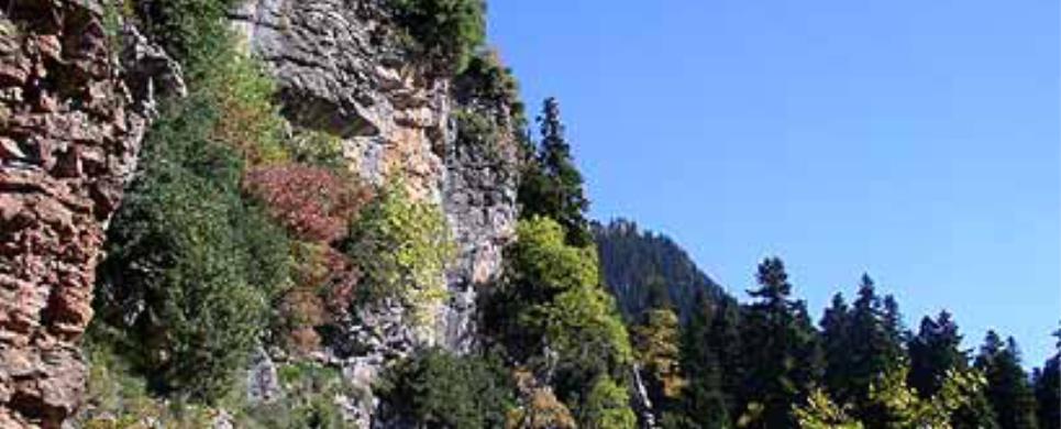
Neraida (1.050 m. altitude) is the most border village of the Prefecture
of Trikala westwards, scrambled on a side of the Eastern Tzoumerka above the Grevenitis
river with unique view to Aspros (Acheloos).
Its tallest crown, Kriakouras (2.100 m. alt.), separates Thessaly
from Epirus.
In the old days it was called Grevenoseli. With this name it is reported
in a gold bull of the emperor Andronicus Palaiologos the 3rd in 1336, which was
found in the temple of the Assumption in Kalampaka and reports that the Bishopric
of Stagon had as limit of its jurisdiction westwards, Grevenoseli.
Part of the residents is natives. Most descendants of Sygizis from
Goustri Xiromerou, who pogrommed by the Turks, came and lived in this place in
the location Kalyvia. The village was transferred in the place that is today before
1850 and its name was taken by the homonym mountain.
Neraida is a village with tourist interest. Places with historical
and archaeological importance that someone can visit are: the Monastery of Agia
Kyriaki, the stone church of Agios Georgios in the square with the traditional
flooring and the ecclesiastical museum in the loft, work of the folkloric architect
from Pramanta, Georgios Dafnis, the ruins of the old church of "Theotokos", which
no one knows when it has been built. (The elders of the village, who were asked,
said that it was a church very old, of immemorial years, monument already from
the Ottoman domination, as the embrasures testify).
Interest also present the platan of Glava, in the shadow of which
sat and spoke to the Grevenoselites, the big teacher of the Gender Kosmas the
Aitolos, Ai Lias that the Germans considered as the base of operations of the
fighters against regime and bombard it without however causing damage, the source
of Glavas with its abundant waters that supplies the village with water and irrigates
the fields, the old - more than two hundred years of life - mill of the church
that still works and the bridge of Grevenitis that was built in the beginning
of the century. Top cultural event of the residents constitutes the two-day revelry
of Agia Paraskevi (26-27 July). For years the Neraidiotes in their majority, try
in every way to be in the village for those days, in order to be present at the
revelry. Because this revelry that withstanded the passing of the time and the
devastating society we live in, has something particular to give them: the genuine
way of expression of the sentiments and the experiences of our ancestors, who
in difficult years accomplished to turn their thorns into dance, song and creation.
Impressive are the natural beauties of the village. From the top of
Kriakouras one can see in the background Ioannina, the
lake and Arta.
There is a cavern over there that keeps snow in winter and summertime from which,
according to the tradition, the Neraidiotes were passing on the sly to Epirus
at the period of the Ottoman domination. The plateau Lakkes offers unexpected
joy to the wayfarer that heads among the imposing, rocky mountains. It is worthwhile
pointing out that in Neraida two magazines are published: The "Grevenoseli" by
Kostas Christakis, a clearly cultural magazine for the history, the folklore and
the culture of Tzoumerka and the "Glavas", body of Cultural Association of Neraidiotes
from where were also drawn most of the elements of this presentation.
The residents of Neraida are neither Vlahoi, nor Sarakatsanaioi; They
are locals and speak Greek with tzoumerkan idioms and accent. Neraida was recognized
as Community of Grevenoseli in 1912, emanating from the former Municipality of
Kothonia. Initially it was consisted of the settlements Grevenoseli (seat), Koryfi
or Kaproi, Sklyveno and Abbey of Agia Kyriaki. The settlement of Kaproi was then
extracted. In March of 1928 it was renamed into Community of Chlorou and on September
of the same year from Chlorou into Community of Neraida.
The village was burned by the Germans in 31/10/1943, fortunately without
victims because from the previous day the anabasis of the conquerors became known
and the residents left. Five people that did not leave in time fell from the bullets
of the enemies. Afterwards a horrible bad weather in 1963 when the village was
in danger from landslips and the disastrous earthquake in 1967, a great number
of residents abandoned the village and many settled in Volos,
Trikala and Arta.
The last 15 - 20 years a current of return in the village is observed, particularly
during the summer months and so Neraida takes life. Neraida is where many famous
stone craftsmen come from. Also, from there many Neraidiotes started who shine
in the political, military and social life of the country.
Today Neraida, as Municipal Apartment belongs to the Extended Community
of Neraida and constitutes its seat.
NERAIDOCHORI (Village) TRIKALA
PACHTOURI (Village) TRIKALA
Pachtouri, one of the most beautiful and developed villages of the
mountainous Trikala. It is built in an altitude of approximately 950 m and is
surrounded by tall, imposing mountains, Tsigori, Tsiardaki, Soufli, Tsiouma, Katafyli,
Zygo. The south side of the village, which is impeded between the mountain range
of Zygos and the torrent Palaiohoritis, has a beautiful and consecutive fir forest,
which is one of the best fir forests in the whole Prefecture of Trikala.
That is why, the village's name P a h t o u r i, for many comes from
the Turkish word "mpahtour" which means "stand and take a look" (the beautiful
environment), while for others it comes from the Arabian Turkish word "Mpahtiar"
which means fortunate - happy. At the most central place of the village, there
is the church of Agios Nikolaos with the tall and impetus steeple and with view
to the fir forest.
Next to the church, stretches the spacious central square with the
big platens, the wooden benches and the traditional cafe.
The residents' love for progress endowed Pahtouri with rich library
and sports fields. Furthermore, the traditional and well maintained communal hostel
can offer a cozy accommodation for the traveller. Studded in the most beautiful
places of the area are five historical country churches which the residents cherish
and visit often.
The great revelry of the village though, is on August 15 and those
who come from Pahtouri from all over Greece gather there in order to participate
in that.
PALEOKARYA (Village) TRIKALA
Mountainous village of the valley of Portaikos (730 m.), that is 10
km far from Pyli,
3 km from Ropoto
and 35 km from Trikala.
It is consisted of the settlements Ano, Kato, Mesi Palaiokarya and Tsimpideika.
The total population does not exceed the 250, while in the summertime
is doubled.
The residents are occupied with the livestock-farming (4.000 sheep).
The arcaded bridge of Palaiokarya's, the dam of Portaikos in Kato Palajokarya,
the forest of Katounas, katafyto with firs and oaks and the tops Gropa and Karavas,
embellish the landscape of the region with particular beauty.
In the forest of Katounas, bears appear with the heavy snowball of
winter, while in the location Aeri of the Mesi
Palaiokarya there is a cavern with underground waters. Project for the growth
of seasonal settlement, is being worked out in the region of Bey that abstains
3 km of earth-road from the village.
Palaiokarya, according to the tradition, was created by the thief
Koutsodaumona, henchman of Stournaras who seceded and took up the region. He was
the winner in the battle with Stournaras for the control of the "man-at arms"
of Aspropotamos and maintained the sovereignty of the village.
Spawn of Palaiokarya's is the poet Kalapanidas. His poem "Our Village"
is found in the spelling book of the 2nd class of the Public school.
In the village there is a private collection with exhibits from the
18th century. Interest develop the churches of Ag. Nikolaos (dates to 17th century.)
and Agia Paraskevi (1810 - 1830). In the festival of Agios Nikolaos, are offered
quantities of a dixie, tripe in the evening of the eve, follows the Service, revelry
and dance afterwards the redundancy.
PETROCHORI (Village) TRIKALA
Six km eastern of Stournaraiika, in an altitude of 650 m., between
the fir forests of Mpouziaras and Mpalarou and underneath the crowns of Psillou
(1.500 m.) and the Prophet Helia (1.010 m.) we meet Petrohori, a small community
of farmer-breeders (350 people in winter and 480 in the summertime).
The forest of Mpalarou, from where the lake of Plastira and Trikala
are visible, the waters of the source and the torrent with the same name flow,
but also waterfall Klironomia or Pouria. Near the village the tributary of Portaikos
Petrohoritis, flows and are the sources Platanaki and Moutsiaropoula. The name
of the location Lolou - Mandri preserves the name of Giorgos Lolos, Stournari's
henchman. Another name round of which histories were woven, is that of the expert
thief Themistoklis Tzimas or Gkoulias.
In the village, the professions of kyratzi and wood - carver are practised.
Distilleries also function and the mill of "Vlasioti" and the old stone house
Hani - Bekou is maintained.
Half hour on foot from the village there are the ruins of ancient
fortification constituted from two parts, the Above and Down Castle that communicate
between them with underground tunnel. Petrohori celebrates two times in a year
with popular revelry and dixies that follow the religious events: on September
8 in the church of Panagia Phaneromeni's and on July 20 in the country church
of Prophet Helia (4 km outside the village). In the way to the Prophet Helia one
can see old thresher places.
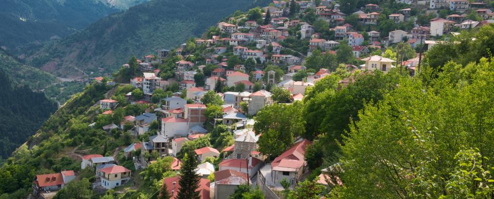
PYLI (Small town) TRIKALA
In the root of Pindos,
in the entry of a magnificent gorge, which separates the mountains Itamos and
Koziakas, but also links
Thessaly with Ipeiros,
18 km western from Trikala,
is found the hamlet of Pyli, county seat of the homonym municipality. Pyli is
also separated from her settlement of Porta - Panagia by the Portaiko's river.
Pyli has 1991 residents (inventory of 1991). It presents particular interest for
the visitor, because it is found in the centre of important Byzantine and post
Byzantine monuments, but also because it constitutes passage for the graphic villages
of Aspropotamos and Arta.
This text is cited Oct 2003 from the WebPage of Municipality
of Pyli
ROPOTO (Village) TRIKALA
Eleven km southern from Pyli,
in an altitude of 750 metres, Ropoto is stretched out that is consisted of seven
settlements: central, Tsekouras,
Panagia, Polythea
(Mousia), Agios Ioannis,
Agjos Dimitrios and
Loggjes. Its residents
mainly, who work on arboriculture but also are farmer-breeders, reach the number
of 850 in the winter and 1300 during summertime.
Right and left the central settlement unfold 3.500 acres of chest
nut wood, where wild boars, wolves, foxes and jackals live, as well as partridges
and woodcocks while all the region round the village is literally drowned in fir
(15.000 acres.). The really picturesque scene of the village, supplement the 15
sources that refresh it - among them those of Goura, Mourtzies, Jtia, Sgourolivado
and Koromilia - and the tributaries of Portaikos river, Ropotianos and Palikarias.
Going up in the famous top of Karavas (1618 m.) one can enjoy an amazing view
of the Thessalian plain. Beginning from there the path leads, through a most beautiful
way on foot, up to Panagia the Spilia of Argithea
Karditsa.
In the village are saved and function watermill, dristella (that belongs
in the church of Agios Ioannis) and four traditionally distilleries with cauldrons.
There is also a craftsman that manufactures ftseles, spindles and other wooden
vessels and tools.
From Easter up to September in Ropoto traditional feasts live up.
In the third day of Easter in the church of Saint Trinity of the Central settlement,
phonetic group consisted of small children, sings songs that are being danced
by all the members of the community with the priests and the chairman being the
leaders. In 7th and 8th of May, the church of Agios Ioannis celebrates with splendour
and folk revelry following the events of worship.
Every two years, in the second fortnight of July, the meeting of the
old is being done in the Central settlement: the ancient of the old invites the
rest, mentioning those who are absent, and all together nominate the chairman
of the meeting, who regulates the order with which the elders recite extemporary
poems that they have made for the circumstance. The meeting ends with songs that
the elders themselves sing and dance.
On July 20 the memory of Prophet Helia is being celebrated in the
county church of the Saint. In the eve tripe is being served and on the day of
the celebration, food from cauldron and the revelry in the Central settlement
lasts two days. In the last Sunday of July is being done, in the location of "Mandri"
with the stone shelter (where also the shear in the first week of June) in an
altitude of 1300 metres, the meeting of all the residents Ropoto with resurgence
of old traditional games, dance, roasting of lambs and offering of boiled milk
with salt and bread (trjpsana) from the cattle-breeders. On the 15th of August
a two-day festival is being done and on September 20 the residents of the village
who follow the old calendar, celebrate the memory of Agios Eustathios in the settlement
of Panagia. Familiar in the neighbors is the history of the murder of the Turk
tax collector Katsimpas in the dues of 18th century, in the location - that since
then brings his name - in the district of Agios Konstantinos.

Receive our daily Newsletter with all the latest updates on the Greek Travel industry.
Subscribe now!