Map & Distances
Show/Hide Map
Distances:
9 Kilometers West-northwest (WNW) the municipality seat
GENISSEA
Small town,
XANTHI
,
GREECE
7,5 Kilometers Northeast (NE)
NEA KESSANI
Small town,
XANTHI
,
GREECE
8 Kilometers Northeast (NE)
POTAMIA
Village,
XANTHI
,
GREECE
3 Kilometers Northwest (NW)
PEZOULA
Village,
XANTHI
,
GREECE
4 Kilometers Southwest (SW)
VELONI
Village,
XANTHI
,
GREECE
11 Kilometers East (E) from the port:
LAGOS
Port,
XANTHI
,
GREECE
21 Kilometers Northwest (NW) the prefectural capital
XANTHI
Town,
MAKEDONIA EAST & THRACE
,
GREECE
3 Kilometers Southeast (SE)
VISTONIAS BAY
Bay,
XANTHI
,
GREECE
Altitude: 50 meters
Longitude: 24o 59' 33.73" E
Latitude: 40o 59' 46.29" N
Hotels, local businesses, destinations & directions
0
Related Destinations
View
2
Hotels & Accommodation
View
5
Businesses & organizations
View all
Domestic sea schedules
as origin
as destination
FIND ROUTES
Local information
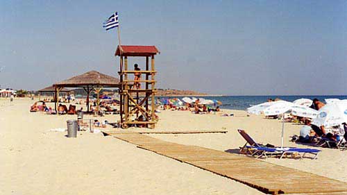
Type of location: Beach, Beaches under Ministry of Environment Inspection, Municipal district, Blue Flag 2014, Blue Flag 2015, Blue Flag 2016, Blue Flag 2017, Blue Flag 2018, Blue Flag 2019
Postal Code: 67100
Residents
Year
Population
1991
635
1981
660
References & Citations
Choose one from the list below or click here to see them all (3)
If you want to find additional information on the greater and/or surrounding areas select one of the titles below and click "more"