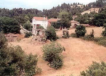
Small agricultural and cattle-raising colony, situated near the road
Rovies-Istiaia
(through Voutas) and at a distance
of about 12 km northerly of Rovies, in fully green pine-trees forests bringing
in mind landscapes found in N. Europe. The geomorphology, the name, the surrounding
toponymies, ruins of old colonies and other historical signs, give proof of a
significant course of the village through the ages (specially in the middle ages).
This text is cited May 2003 from the Municipality of Elymnies tourist
pamphlet.
Photo gallery
Map & Distances
Distances:
145,5 Kilometers South-southeast (SSE) the prefectural capital CHALKIDA
Town, EVIA
,
GREECE
Altitude:
400 meters
Longitude:
23o 14' 30.32" E
Latitude:
38o 52' 08.26" N
Hotels, local businesses, destinations & directions
If you want to find additional information on the greater and/or surrounding areas select one of the titles below and click "more"
We could't find news articles relevant to this location/area.
Latest Travel & Tourism News from GTP Headlines
Greece to Subsidize Holidays for 107,204 People This Year
A total of 107,204 people will be going on holiday this year subsidized by the Greek state with up to 400 euros as part of the "Tourism for All" program.
...
Athens Airport CEO Yiannis Paraschis adjusted initial revenue projections upward in light of positive Q1 data, forecasting arrivals to reach 30 million in 2024....
Greek Tourism Minister and Ambassador for Singapore Talk Investments
Greece's attractiveness as an ideal destination for high-quality investments in the hotel sector was on the agenda of a meeting between Tourism Minister Olga Kefalogianni and the Ambassador for Singapore Simon Tay....