Listed 100 (total found 103) sub titles with search on: Main pages for wider area of: "IONIAN ISLANDS Island complex GREECE" .
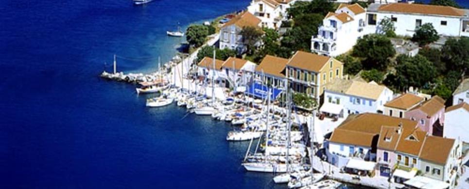
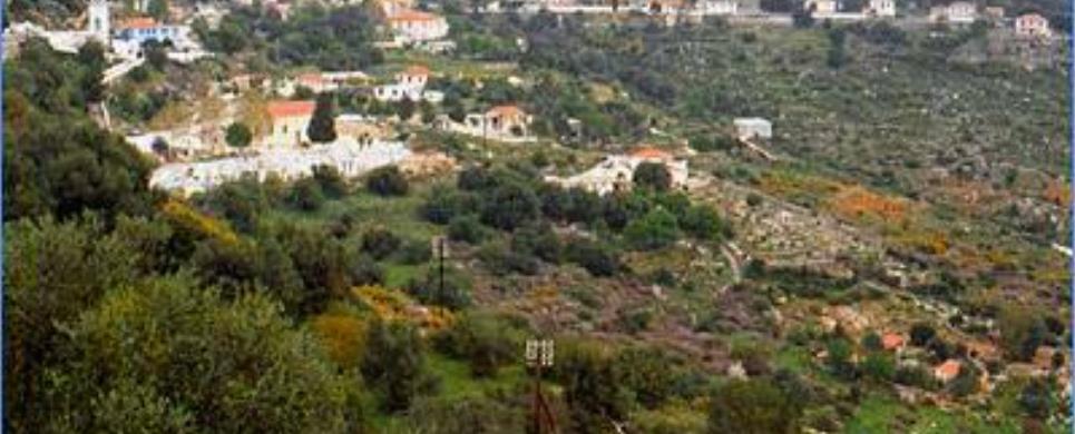
AGIA EFIMIA (Village) KEFALLONIA
Aghia Efimia is situated at the eastern part of the island and it
is an exceptionally picturesque village with rich vegetation. At its port ships
from the opposite coast (Sterea
Ellada) put in. Aghia Efimia is developed as far as tourism is concerned and
offers every possible amenity to the visitor.
This text (extract) is cited January 2004 from the Assoc.
of Local Authorities of Kefalonia & Ithaca tourist pamphlet.
AGII DOULI (Village) CORFU
Tel: +30 26630 94255
AGIOS GORDIOS (Settlement) CORFU
A relatively new settlement in a charming location with blue water and golden
sand. Rightly regarded as one of the island's finest beaches. From it you can
visit the picturesque village of Sinarades,
and Aerostato, which took its name from a coffee shop which seemed literally to
be hanging from the heavens.


AGIOS ILIAS (Village) LEFKADA
Tel: +30 26450 39225
Fax: +30 26450 39225
Above Syvros is the village
of Ayios Ilias, built at a very high altitude. It is the second highest mountain
village on the island after Englouvi
and the vegetation here is quite sparse because of the altitude. Ayios Ilias was
an old refuge for the locals seeking sanctuary from the regular pirate raids,
and flocks of sheep and goats were also kept here in the summer. Marantochori,
a large village with a long tradition, lies on the central road which leads from
Nydri to Vasiliki.

AGIOS MATTHEOS (Small town) CORFU
Tel: +30 26610 75142
A large, but charming village, with buildings both new and old. A paved road leads
to the Monastery of the Pantokrator at the top of the hill. Also at the top of
the hill is the Hole of Pelaos, a cave which is said to communicate with the sea.
In the fertile Gardiki district there is another Venetian castle, a twin to Aggelokastro.
It too belonged to the Despotate of Epirus. It is octagonal, with towers at each
corner. As happened elsewhere in Greece, the remains of ancient temples have been
incorporated into the walls of the castle.
AGIOS NIKITAS (Village) LEFKADA
Tel: +30 26450 97469
Fax: +30 26450 97465
Twelve kilometers form the capital of the prefecture, adjoining the
sea, looms the traditional fishing village of Agios Nikitas. Traditional houses,
amphitheatrically arranged in the verdant landscape around the sea, give their
own gift to the passage of time. Very quiet with a view to the endless azure of
the Ionian Sea and the misty
tops of the mountains of Epirus,
it attracts the visitor like a magnet, calling him to live in the pure nostalgia
of nature.
The crystal clear waters at the beaches from Langada to the village,
the fresh fish and also the traditional hospitality of the people of Lefkada,
will transport you to a different way of life and will fascinate you. Further
west of the settlement is the unspoiled sandy beach of Mylos, which is sure to
win the heart of even the most demanding visitor.
This text (extract) is cited December 2003 from the Lefkada
Hoteliers Association tourist pamphlet (1998).
ANAFONITRIA (Village) ZAKYNTHOS
Tel: +30 26950 31109, 31211
ANO VOLIMES (Village) ZAKYNTHOS
Tel: +30 26950 31499, 31214
ANTIPAXOS (Island) IONIAN ISLANDS
The only harbour on Antipaxi with level land on the shore in Agrapidia. Larger
vessels do not moor there, the water being too shallow. The only village, Agrapidia,
is set amid vineyards. The beautiful beaches of the island can be reached with
speedboats, which every day shuttle to and fro with tourists from Paxi.
There are some small tavernas where one can find food and relaxation after a day
at the beach. There is a stream of fresh water coming into the sea at Kaloroi
Beach. Antipaxi is a place for a quiet, peaceful holiday.
This text is cited December 2004 from the Ionian Islands Region General Secretariat URL below, which contains image
ANTISAMOS (Beach) KEFALLONIA
A pleasant surprise awaits the visitor after reaching Dichalia and starting to descend to Antisamos Beach. A splendid canvas of green is painted in all imaginable shades of blue and white.
From that vintage location, the view of the emerald beach is an awesome experiences for the senses, every single time.
The turquoise waters of the Ionian Sea reach out to embrace the incredibly white pebbles which in turn fade into the magnificent green surrounding scenery of the mountainside.
Antisamos is one of the best beaches on the island and the entire Ionian region as well.
It is this untamed beauty that captured the imagination of the producers of "Captain Corelli's Mandolin" when they decided to use it as a location for the filming of the movie.
This text (extract) is cited April 2010 from the Municipality of Symi web site.
ARGOSTOLI (Town) KEFALLONIA
Argostoli, with a population of 8000 people, became Cephalonia’s
capital in 1757.
Even though many of the town’s imposing mansions were destroyed
during the 1953 earthquakes, the new town which was built kept the quaint, Ionian
style with well-laid out streets, spacious squares, many trees and alleys and
a very lively port.
In the centre of the city there are the Administrative House, the
Town Hall, the Archaeological
Museum, the Korgialenio
Popular Art Museum, the Korgialenios Library and the newly-built "Kefalos"
Theatre.
At the port, the visitors can see Nikos Kavadias’ bust gazing
to the endless sea. Kavadias was a poet who loved and wrote about the sea during
his whole life.
From the few works of the island’s British period which the
earthquakes didn’t destroy is Koutavos bridge, built in 1813, which connects
Argostoli with the opposite coast.
Walking along Lithostroto (stone-paved street), the town’s central
street, take a minute to visit Aghios Spiridonas’ church and Kambana square.
Reaching the street at the port, you will see the market full of fresh
fish and sweet-smelling fruit and vegetables. Further down many pastry shops and
restaurants invite you to taste the local dishes.
The people are hospitable, warm-hearted, easy-going and will not fail
to help you and make your stay a memorable experience.
This text (extract) is cited January 2004 from the Assoc.
of Local Authorities of Kefalonia & Ithaca tourist pamphlet.
ASSOS (Village) KEFALLONIA
One of the most picturesque places of the island. Is a very popular
destination with many visitors during the summer. The village was built amphitheatrically
round Assos creck and has a beautiful beach. Walking around its narrow streets
one can see beautiful houses with flowerfull gardens and one gets the impression
of what Kefalonia was like many years ago.
There are restaurants, cafes and other shops most them gathered round
the main square with it's beautiful plane and oleander trees!
The real jewel of Asos is it's castle from where one can admire the
panoramic view.

ATHANI (Village) LEFKADA
Tel: +30 26450 33146
A picturesque mountain village looking down on the seashore of Gialos. Following
the route south along the rocky southern coast through rugged but extremely beautiful
countryside one can get to the marvellous beaches of Engremni and Porto Katsiki.
At the termination of the route we arrive at the southernmost point of the island,
the Lefkata Promontory. It is near here that the ruins were discovered of an ancient
temple of Apollo Lefkata. According to the ancient poet Menander, the poetess
Sappho of Lesbos fell
from here onto the rocks when Phaedon didn't return the love she had for him.
In front of us is the Ionian
Sea. The sunset from here is a sight worth seeing.

BENITSES (Small town) CORFU
Tel: +30 26610 72284
The coastal region of Benitses, very developed as a tourist area, with hotels,
tavernas, restaurants and nightclubs. Dense vegetation and beautiful beaches are
typical of the area. It is said that the gardens of King Alkinoos were situated
here. The springs providing waters to the Corfu Aqueduct are in the area, as are
ruins of Roman baths with mosaic floors.
CORFU (Island) IONIAN ISLANDS
Lovely Corfu, green and sun-drenched with its indented shores, a mythical,
fascinating island, first appeared on the scene at the dawn of time when she gave
refuge to Jason and the Argonauts on their return form their quest for the Golden
Fleece.
The description of "the island of the Phaeacians" in the
Odyssey, Odysseus’ last stop before arriving in his beloved Ithaca, is among
the most beautiful verses in world literature.
The incomparable beauty of the island, which appears from time to
time under other names, attracted a host of would-be conquerors. It also inspired
artists of every kind, who praised its charms in words and music or rendered them
in paintings, sculptures or engravings, spreading its renown to a wide public
over the past few centuries.
Literary figures such as Goethe, Oscar Wilde, Gerald and Lawrence
Durrell, the painters Alfred Sisley ad Edward Lear, immortalized with their pen
of palette Corfu's inimitable enchantment.
Even the great Napoleon was not unmoved by its beauty.
It was here that the sensitive empress Elisabeth of Austria
erected the Achilleion, the palace she viewed as the solace of her soul, while
according to Lawrence Durrell, Prospero’s island in The Tempest is modeled
on Shakespeare’s notion of Corfu.
Corfu was the birthplace of Greece’s
first governor, Ioannis Kapodistrias, of the composer Nikolaos Mantzaros (who
set to music Solomos’s "Hymn to Liberty", the country’s
national anthem), of the writers Polylas, Markoras, Mavilis, and Constantine Theotokis,
as well as being a source of inspiration to Greece’s national poet, Dionysios
Solomos. Today it continues to attract and delight its countless visitors.
(text: L. Briola)
This text (extract) is cited November 2003 from the Greek
National Tourism Organization tourist pamphlet (1993).
CORFU (Town) IONIAN ISLANDS
Corfu, one of the most beguiling cities in the Mediterranean, lies in the middle of the east coast of the island. It has grown up along a narrow strip of land that juts out into the sea. Its unique beauty is the product of the curious mixture of architectural styles left behind by the various occupying civilizations, blended into an especially harmonious whole.
The old city is the largest "living" medieval town preserved in Greece. Its streets wind and wader with no discernible order or object, its picturesque cobble-stone alleyways are interrupted by statues, graceful churches, Venetian tenements and fountains; the only way to see them is on foot.
The new section of the town is inseparable from the old, so that broad avenues with large piazzas can be found cheek by jowl with the cobbled lanes. Corfu's main square is the Spianada or Esplanade, rightly judged the most beautiful in Greece. Hotels combining the latest amenities with respect for their surroundings lie at various points round town. Some of the city's houses - two-storeys and higher - are in the English Georgian style, others display a strong French influence, while others are Italianate or in the island tradition. Arcades and arches decorate them, as do balconies with artfully designed wrought-iron railings.
Originally, Corfu was a fortress-state whose inhabitants lived within the walls of the Old (Sea) Fort built on the foundations of an earlier Byzantine castle that the Venetians reinforced and expanded in 1546. It is separated from the rest of the town by a moat, the Contrafossa, which used to be spanned by a moveable wooden bridge. The New (Land) Fort above the old harbour was erected between 1576 and 1588 to protect the town in the event of a Turkish invasion. The coast road with its graceful lampposts follows the medieval sea walls, the Mourayia. Its natural borders, the emerald sea on one side and lush greenery on the other, make it exceptionally lovely.
(text: L. Briola)
DASSIA (Settlement) CORFU
Dassia is a developed tourist area with big hotels and a variety of options open
to the visitor: blue waters and clean beaches, olive groves coming down right
to the water's edge. The gothic-style villa of Bibeli numbers among the sites
of interest to visitors.
ERIKOUSSA (Island) IONIAN ISLANDS
Tel: +30 26630 71703
Ereikoussa, an islet within the Diapontia island complex, is located northwestern of Corfu. It is a round island with a diameter of some 2 kilometers and is covered with olive and cypress trees. The permanent residents mainly specialize in olive-oil production, fisheries and tourism.
The highest peak of the island is Merovigli with a 120-meter altitude. Visitors are advised to ascend to the Anemomylos (windmill) site as it features a breathtaking view. On the south coast of the island, where the settlement of Porto is located, there is a huge shallow sandy beach that attracts many visitors from Corfu. From there, a path towards the north of the island, through the lush greenery, leads to the beach Prangini.
Popular beaches include Brakini that has shallow waters and is located on the east coast, and the old harbor Fyki, located on the west coast.
It is said that the island was named Ereikoussa due to the vast quantity of briar plants (reiki in Greek) on the island. The briar plant has a purple pink color, a characteristic smell and it blooms in October.
ERISSOS (Municipality) KEFALLONIA
The municipality of Erissos covers the north part of the island of
Kefalonia and is known for
its exceptional beauty. The road network which connects all the villages, passes
through beautiful scenery and meets the main road arteries of the island. Driving
through precipitous roads one can enjoy the view of picturesque landscapes, creeks
and dramatic clifs. During your trip you have the opportunity to visit the famous
village of Asos, the old capital
and important port of the island, in 1593, with the Venician Castle of 16th century
on top of the hill and the prisons where prisoners had to work as field hand workers
up to 1953.
About 2 kms past Asos on the way to Fiscardo,
one can visit the 1600 built monastery of Theotocou (Gods mother) where every
8th of September there is a celebration. The house hold icon of Godmother is named
(Wider than the skies) "Platirera ton ouranon".
On the way you also have the opportunity to wander beautiful little
villages where in a lot of them that survived the 1953 earthquake, you can distinguish
the Italian influenced architecture.
Fiscardo is an old fishing village in which all the houses survived
the 1953 earthquake. Today it is one of the most popular and touristy-holiday
places in Greece, well known for its traditional architecture and breathtaking
picturesque beauty, as well as its cosmopolitan little natural port. Fiscardo
is the home town of the sea poet Nikos Kavadias and it took it's name from the
crusader Robert Guiscard. Fiscardo is surrounded by beautiful little villages,
glistening creeks and other places such as Foki & Evreti
with the wonderful cypress forests. The eastern villages of the municipality are
situated opposite the island of Ithaca,
through time, witnessing the world evolution and looking towards the future.
This text is cited June 2003 from the Municipality of Erissos URL below, which contains images.
ERMONES (Settlement) CORFU
A seashore with steep rocks and icy-cold waters. This is said to be the place
where Nausicaa came with her friends to wash their clothes in the running waters
of the spring and so met Odysseus. The "Corfu Golf" is in this area.
There are still some traces of Neolithic remains to be seen in the vicinity.
FISKARDO (Village) KEFALLONIA
Fiscardo is situated in the most northern point of the island opposite
the island of Ithaka and is
famous for its traditional architecture and its cosmopolitan port.
It is one of the most important tourist and holiday destinations of
the island with soundly organised tourist background.
Many yachts arrive at Fiscardo's port where their owners most of the
times decide to stay for the rest of their holiday.
Something similar happened to crusader Robert Guiscard from whom Fiscardo
took its name, who arrived in 1085 in order to conquer the island, but finally
stayed and lived in Fiscardo for the rest of his life. Most of the mansions (stately
houses) one can see in Fiscardo belong to the Venetian architecture era.

GASTOURI (Village) CORFU
The village of Gastouri is set amid beautiful scenery on a green hillside. Dominating
the hilltop is the Achillio, built for the Empress Elizabeth of Austria, the renowned
Sissy, in 1890-91 by the Italian architect Kapita. The Empress had a soft spot
for the Homeric hero Achilles, and so named her palace after him. The neoclassical
building is set amid magnificent gardens. The back part of the garden is dominated
by the statue of "Achilles Dying", a creation of the German sculptor
Herter. Some of Sissy's personal possessions are kept on the lower floor of the
palace. After her murder the Achillion was purchased by Kaiser Wilhelm II of Germany.
ITHAKI (Island) IONIAN ISLANDS
Northwest of Cephalonia
is situated the historic island of Ithaki, Ulysses’ homeland. The island
is believed to have been named after the mythical hero Ithakos.
It is a long, narrow island and its two peninsulas are linked together
with Aetos’ isthmus.
Vathi is the island’s
capital. Lefki, Kioni,
Frikes, Anogi,
Exogi, Perahori
and Stavros are Ithaki’s
main villages.
As it happens in the whole Eptanissa
complex, Ithaki combines perfectly the beauty of the all-green mountains with
the crystal clear blue sea.
Its beaches enchant the visitor and the trees reaching the beach create
a scenery of unique beauty, combining wildness with tranquility.
This text (extract) is cited January 2004 from the Assoc.
of Local Authorities of Kefalonia & Ithaca tourist pamphlet.
ITHAKI (Small town) IONIAN ISLANDS
The capital of the island is situated inside a sheltered cove of Molos Bay which
seems like a lake. The houses, which were rebuilt after the earthquakes of 1953,
are as before in the traditional architectural style. The blue waters and the
verdant islet of Lazaretto in the middle of the harbour make a good first impression
on the visitor.
KALAMOS (Island) IONIAN ISLANDS
Kalamos is not a conventional island. It is a tall mountain range
which floats on the sea, its northern side overgrowing with towering, thick pine
trees. It is obvious to even the non-specialist visitor that these pines are of
a special species.
They perch everywhere, even at the most precipitous points, sprouting
from the rocks and reaching as far as the edge of the sea, as though they insisted
on demonstrating their superiority over the place.
Even at the first sight from a distance, then, Kalamos captivates
with its unusual, wild landscape. Kalamos has a surface area of around 20 square
kilometres and a highest mountain peak of 200 metres.
There are around 580 permanent residents, increasing in the summer
when friends and relatives visit the island.
The centre of the island is the port of Kalamos, which is on the eastern
side. This is where many people sailing the Ionian moor their boats in order to
visit the island, enjoy some seafood at a seaside taverna or seek refuge from
bad weather.
Work being carried out for the widening the port will increase the
number of boats that can be moored here and ease sea transport, which is the island's
only means of communication with the rest of the world. A caique makes four to
five connections to and from Mytika daily in the summer, bringing passengers and
all types of goods to cover the needs of the island's few residents. The island
has a simple, rural atmosphere.
The houses of Kalamos, clambering high above the port, are stone-built,
most with tiled roofs, built tightly-packed next to each other and intersected
by narrow, winding lanes.
The road which connects the port with the village rises quite steeply
and has many bends. The few cars, used mainly for transporting goods, drive carefully
along the narrow roads. A new road starting at Kalamos ascends high into the mountains
and passes through an amazing pine forest, terminating at the island's other small
village, Episkopi.
Here the few houses, worn by time, are used as summer residences,
drawing their owners to Episkopi each year. It is as though time stopped 50 years
ago. The residents' boats, a vital means of transportation and communication with
the rest of the world, are kept at the small, new port. Episkopi is only ten minutes
from the port to Mytika
on the mainland coast of Aitoloakarnania...
On the other side of the island is Porto Leone, a charming, little
bay so named by the Venetians who first drew up the maps of the area. Nearby
is an old bridge built many centuries ago. The pine forest is very rare and the
only other forests of this type are found on the Sporades
islands in the Aegean Sea. It is a thickly-grown verdant forest, powerful and
vibrant and home to many species of birds. The road from Kalamos to Episkopi also
leads down to the little beach of Ayios Konstantinos. Here, right in front of
the waves, there is a small and pretty private church dedicated to Ayios Donatos,
a saint encountered mainly in the Ionian Islands. Built in stone with a ceramic
tile roof, it stands alone with only the thick foliage to keep it company; soon
it will be in need of care, however, in order to protect it for the future.
Ayios Ioannis, which is one of the oldest churches on the island,
is almost completely ruined. A plaque still remains with an inscription (1648)
of the date when the church was most likely built. Other churches are the church
of Ayios Minas, the church of Episkopi, and Ayios Georgios in the cemetery.
The island has long been farmed. Its mountain is lower in the centre
and towards the south and is much easier to farm at this point. In the past there
was also vine cultivation, but all that remains of this today are the walls that
were used to hold the earth in. There are many olive trees and three windmills
at Agriapidia, where
the whole harvest would be gathered. Kalamos has small, mainly pebbly, beaches
with brilliantly clean waters, access to which is mainly from the sea.
Near the port are the beaches of Myrtia and Asproyiali, whilst further
south are Agriapidia, Pefkoi and Kefali with Kedros, Alexaki, Kipoi and Trachilos
to the west. The island also has some interesting caves.
The road that goes from Kalamos to Episkopi has not had much of an
effect on the landscape and is ideal for all those who delight in rambling through
a beautiful natural environment. The island has only a few cultural monuments.
It does, however, have a remarkable natural landscape and an atmosphere which
transports the visitor to eras long gone. ve a remarkable natural landscape and
an atmosphere which transports the visitor to eras long gone.
This text is cited April 2004 from the Prefecture of Lefkada URL below, which contains images

KAROUSSADES (Small town) CORFU
Tel: +30 26630 31311

KARYA (Small town) LEFKADA
A mountain village of Lefkas, with a tradition in embroidery, some of which is
on display at the Folk Art Museum. If you visit the village on 11th August you
can see a representation of the Lefkadian wedding. At the old monastery of St.
George at Skari you can see remarkable 17th century frescoes. You can get to it
by following the road to Nikiana.
KASSIOPI (Village) CORFU
A town built on the site of an ancient settlement. Kassiopi flourished during
the Roman period, chiefly on account of its geographic position overlooking the
sea pass. In ancient times there was a sanctuary to Zeus here, on the site now
occupied by the 16th century Panagia Kassiopitissa. The ruins of the town's castle,
dating from the 14th century, can be seen on the hill. A number of narrow streets
lead from the harbour to the town's beaches. Kassiopi is an ideal point of departure
for visitors wishing to explore all the northern part of Corfu.
This text is cited December 2004 from the Ionian Islands Region General Secretariat URL below, which contains image
KASTOS (Island) IONIAN ISLANDS
Kastos is a low-lying, long and narrow little island covered in olive
trees and at which dozens of boats sailing over the Ionian Sea moor safely each
day. It is also an excellent place for fishing. It has only fifty permanent residents,
which rises to 500 in the summer when friends and relatives gather here.
Kastos has a greatest width of 900 metres and a surface area of six
square kilometres. It has many low hills, the tallest of which is no higher than
150 metres. The island's west coast is rugged, whilst the east coast has many
small beaches, which can be accessed from land or the sea. These are Ambelakia
and Fyki in the south, Vali, Koilada, Ayios Aimilianos, Limni, Kamini and Vrisidi...
There are only a few roads on the island, and it is for this reason
that there are no cars. The distances are very short and the people move around
on foot and, of course, by boat. Every resident of the island has his own boat
or small speedboat. The Saracene bay, the natural bay on the west of the island,
also has a small mole which makes anchorage possible even during bad weather,
so that the island will not be cut off by the strong southerly winds...
At Kalikerimi there is an olive grove with very old olive trees. They
are tall with thick trunks and giant roots which indicate that they must be several
hundred years old. At Ayios Aimilianos, a little to the north of the port of Kastos,
there is a small cave, Fokotrypa (Seal Hole). It is around 30 metres deep with
a little sand within it. From its name we can conclude that in the past seals
would seek refuge here. The island's pathways provide for pleasurable walks and
are generally quite accessible and straight.
The view from the pathway along the ridge which goes towards the north
is exceptional. In addition, the small road which was recently built provides
for a delightful stroll through the verdant landscape, which exudes a sense of
peace and calm. The ancient remains at Vigla are evidence for the possible relationship
of the island with Meganisi
and Kalamos from ancient
times (the Tafios islands).
Kastos is linked by caique with mainland Greece. There are a few connections
each day to and from the coast of Mytikas
on the other side of the island, which is also Kastos' central marketplace. The
caique is the island's only connection to the outside world. The island has fanatical
supporters who come here each summer to pass a few carefree and peaceful days
in an atmosphere that is different and in an environment that is still clean and
unpolluted, as though it were located on the edge of the world.
This extract is cited April 2004 from the Prefecture of Lefkada URL below, which contains images
KASTOS (Village) IONIAN ISLANDS
The village of Kastos is built around the harbour in an amphitheatre pattern.
The houses, most of which are boarded up, are very spread out on large plots of
land and surrounded by olive trees, giving a feel of comfort and openness. They
are all two-storey, made of stone and with red-tiled roofs and wooden window-shutters
painted in different colours. Many of these houses have large balconies with large
doors leading onto them. This picture exudes the comfort of earlier days, and
a visitor who comments that it is reminiscent of Greece in the 1960s would be
quite justified. The village has a few restaurants which specialise in seafood,
serving the fresh fish trawled up by the island's fishermen. A proper water supply
system was recently installed on Kastos, thus easing the lives of the residents.
This extract is cited April 2004 from the Prefecture of Lefkada URL below, which contains images

KATASTARI (Small town) ZAKYNTHOS
The largest village on Zakynthos, renowned for the hospitality of its inhabitants.
There is one peculiarity that lends a note of difference to Katastari: the village
is abruptly interrupted by a little used road and after it comes the rest of the
village built in the shape of an amphitheatre overlooking the bay of Alykes.
The light breeze which often blows in the area makes the hottest summer days cool
and pleasant. The visitor must take a look at the church of Agioi Theodori, in
which after the 1953 earthquakes the inhabitants gathered together what remained
from the demolished churches of the area.
KEFALLONIA (Island) IONIAN ISLANDS
Cephalonia is the largest and most mountainous island in Eptanissa.
It is situated to the south of Lefkada,
west of Ithaki and north of
Zakynthos.
It is an all-green island, which offers variety and sharp contrasts
in scenery. Argostoli is the
island’s capital and also gives its name to the nearby bay. Opposite Argostoli,
in Palliki peninsula, is situated
Lixouri, the second most important town of the island.
Cephalonia’s coasts form either small bays or gulfs with magnificent,
wind-protected beaches, ideal for swimming and sunbathing or steep cliffs where
the wild rocks meet the deep blue Ionian
Sea.
Cephalonia’s flora is renowned for the unique variety of black
fir called the "cephalonian fir" which can only be found without hybrids
on the highest mountain of the island, Mount
Enos.
This text (extract) is cited January 2004 from the Assoc.
of Local Authorities of Kefalonia & Ithaca tourist pamphlet.

KERI (Village) ZAKYNTHOS
Tel: +30 26950 43701, 43324
Keri is a very attractive village. It is well-known for the legend surrounding
its church, the Panagia of Keri. It is said that once upon a time the Panagia
concealed Zakynthos in dense fog to protect it from pirate raids. It is worth
going to the lighthouse on the promontory to see the two Mizithres: two big stones
towering over the deep blue waters.
KOULOURA (Settlement) CORFU
A little fishing port, which takes its name from the shape of its cove. The ruins of a building from the Venetian period can be seen here, formerly a residence belonging to the first governor of Modern Greece Ioannis Capodistrias.
KOURKOUMELATA (Village) KEFALLONIA
A modern village rebuilt after the 1953 earthquakes in the traditional style with donations from the family of the shipowner Vergoti. The village's Cultural Centre is housed in a neoclassical building. There is a marvellous view from Kourkoumelata over the Ionian Sea.

LAKKA (Village) PAXI
The village of Lakka took its name from its position. Its houses are built at
a low elevation and close to the sea. The view from the lighthouse is superb.
It is worth visiting the Ellinospito, a kind of fort, where the locals sought
refuge when pirates came to the island. Similarly of interest is the Ipapandis
Church, built in 1774. Renaissance elements can be seen in its ornamentation.
One could also visit the Sea Cave of Ipapandis, which is said to communicate with
the church and with the Grammatikos Mansion.
LAKONES (Village) CORFU
A typical Corfiot village on a green hillside. It is worth taking a walk to Bella
Vista, where the visitor can lounge in one of the charming coffee shops and admire
the view over the bay of Palaiokastritsa. If you like rambling outdoors you can
follow the steep path which will take you to Palaiokastritsa village.
LEFKADA (Island) IONIAN ISLANDS
Lefkada is one of the Ionian Islands, known as the 'Eptanisia' in
Greek, which lie in the Ionian Sea. The island is less than 100 metres from the
mainland coast of Akarnania, to which it is linked by a floating bridge. The channel
of Lefkada is 50 metres wide. Lefkada has an area of 302.5 square kilometres and
is the fourth largest of the Ionian Islands with a population of 23,000. The Prefecture
of Lefkada consists of Lefkada and the surrounding small islands of Meganisi,
Kalamos, Kastos,
Skorpios, Skorpidi,
Madouri, Sparti,
Thileia and Kythros.
The Prefecture is divided into six municipalities and two communities. Lefkada
has a Mediterranean climate. It has many hours of sunlight daily and is typified
by mild winters with increased rainfall and hot summers with cool breezes. 70%
of the island's terrain is mountainous. It has tall mountains, the tallest peak
being in the centre at Stavrota (1182 m.). The western side of Lefkada is precipitous
with many long, sandy beaches.
It also has narrow plateaus, fertile valleys and ravines with rich
vegetation. Olive trees are spread over the whole island whilst cypress trees
grow here and there, creating a distinct landscape. The island's exceptional flora
includes many pine forests and some forests with a special variety of oak tree.
Another variety of tall and thick pine tree which grows on the edge of the sea
is to be found on the island of Kalamos. Lefkada has plenty of waters, mainly
springs but also streams which flow from high above, creating small waterfalls.
In the north of the island is a lagoon which provides an important wetland environment
for many species of birds.
The landscape is complimented by the traces of human habitation, old
and new. Agricultural buildings, such as the dozens of watermills, the olive presses,
threshing floors, the simple stone-built houses and the unique domed stone dens
are evidence of the importance of farming on the island. The salt-pans and fish
farms indicate another side of life on Lefkada. The churches and the monasteries
provided support to the Greek and Christian culture of the island during the difficult
years of the Tourkokratia (Turkish rule), roviding an artistic escape through
the Byzantine tradition and western influences. The icons and wall-paintings are
unique works of art. The town of Lefkada itself, with its historic centre, town
houses and narrow lanes and the Kastro of Ayia Mavra (Santa Maura) - these are
the unique features which go to make up the cultural heritage of the island. They
tie together the precious memories of the past and lead us to the Lefkada of today.
This text is cited April 2004 from the Prefecture of Lefkada URL below, which contains images
LEFKADA (Town) IONIAN ISLANDS
The town of Lefkada, whose history goes far back into the mists of
time, is associated with Sappho and Phaon, Apollo and Artemis, the Trojan War,
Odysseus and the Homeric Ithaca, with East and West, with her destiny. The town,
which has been the vital heart of the island since medieval times, is today a
friendly, modern city. A number of significant figures in arts and letters originated
here, including the poets Aristotelis Valaoritis, Angelos Sikelianos and Lefkadios
Hern, historian Nikos Svoronos and others. The town has been characterized by
the Ministry of Culture as a "region of particular natural beauty",
and by the late art historian Angelos Prokopiou as a "geological phenomenon".
It features crystal clear waters, a coastline lacey with coves and inlets, the
beaches at Aghios Ioannis
and Gyra, and the mills; it is full of sights such as the medieval Venetian fortress
and basilica churches with interesting carved wooden icon screens. It has a folklore
museum and an archaeological museum and art gallery featuring post-Byzantine icons.
It has a large number of cultural associations and a historic philharmonic
orchestra, and hosts festivities in August, celebrating Literature and Art and
the International Folklore Festival, all of which offer unique artistic experiences
to local people and visitors alike. It is a town, which offers fresh, inexpensive
fish in traditional tavernas, Ionian serenatas, and the hospitable spirit and
warmth of its people. It’s a town with nightlife, full of movement, passions
and dreams, a town in which the visitor can come and go 24 hours a day thanks
to the causeway connecting it to the mainland. It is also a base from which one
can visit the mountainous areas of the island, and travel to the nearby island
of Meganissi, Cephalonia
and Ithaki, taking advantage
of the frequent and regular boat services and the good roads.
This text (extract) is cited December 2003 from the Lefkada
Hoteliers Association tourist pamphlet (1998).
LIVATHOU (Municipality) KEFALLONIA
Livatho area spreads along the southern part of the island. Here,
the visitor can enjoy swimming in one of the picturesque beaches such as Lourdas
and Avithos. Once in the area, do not forget to visit Metaxata
village to see the house where Lord Byron lived for a while, in 1824, before
going to Messolonghi.
Touring around Livatho, it’s worth visiting Ntomata
and Kalligata, two villages
whose churches are decorated with magnificent wooden carved icon screens.
The sights of the area also include Ag.
Andreas’ Monastery and Ag.
Georgios’ Castle.
This text (extract) is cited January 2004 from the Assoc.
of Local Authorities of Kefalonia & Ithaca tourist pamphlet.
LIXOURI (Small town) KEFALLONIA
Lixouri is the second largest town with a population of 3500 people,
according to the most recent census.
It is situated in Palliki
peninsula and there is regular ferry boat transport from Argostoli.
The visitor can also reach Lixouri driving around the big bay of Livadi.
Lixouri is divided in two parts by a stream and small bridges connect
the two banks. It is a modern town with big streets full of trees and spacious
squares.
At the town’s port, you can see Andreas Laskaratos’ statue.
Laskaratos was a satiric poet who came from Lixouri and lived in the 19th century.
Furthermore, liberal politicians’ busts, such as Typaldos-Iakovatos,
Pylarinos and Typaldos Kapeletos-Dotoratos can be seen around the town.
Distinguished benefactors like P. Vallianos, S. Petritsis, the Basias
brothers and others helped to reconstruct the town after the terrible earthquakes
in 1953.
The inhabitants of Lixouri, as all Cephalonians, are famous for their
love and talents in music, literature and art in general. In this frame we should
not fail to mention Pali’s Music School which was founded in 1836 and it
is one of the oldest and most important in Greece.
Lixouri is very famous for the rich cultural events.
Its Carnival is renowned for its sense of humour and satire and it
is the prevailing happening in winter.
The whole island participates in it and apart from its variety and
its humorous sense it also possesses a Dionysiac aspect.
It is regarded as one of the most successful provincial carnivals.
During the summer season, the Cultural
Centre of Lixouri Municipality in collaboration with other Municipalities
and authorities organises various cultural events.
Lixouri’s sights also include Laskaratos’ hill, Iakovatos
Library, the Archaeological Collection and numerous magnificent churches with
wooden carved icon screens.
This text (extract) is cited January 2004 from the Assoc.
of Local Authorities of Kefalonia & Ithaca tourist pamphlet.

LONGOS (Village) PAXI
Longos nestles amidst dense vegetation, which reaches as far as the harbour. The
shallowness of the water makes it impossible for larger vessels to dock. The beaches
of Levrechio, Marmari, Kipo and Kipiadi are suitable for swimming, windsurfing,
and also camping. If the visitor is looking for unspoilt beaches, Fikia and Glyfada
are worth visiting. Also of interest is the oil-press of the Anemogiannis family,
one of the oldest families of Paxi. The churches of Agios Nikolaos, patron of
sailors, and Zoodochou Pigi, have some frescoes of interest to a visitor.
LOURDATA (Village) KEFALLONIA
Tel: +30 26710 31425
The village of Lourdata is situated in a verdant, fertile region. The waters of
Enos and the protection afforded
by the mountain greatly heighten the fertility of the village gardens and orchards,
which go right down to the sea. The Cephalonians relish the fruit and vegetables
from the gardens of Lourdata, which are very tasty. The village's fine beach,
which is also large, every year attracts crowds of holidaymakers, Greek and non-Greek.
LYGIA (Village) LEFKADA
Tel: +30 26450 71394
At a distance of 5 kilometres from the town
of Lefkada we reach the first coastal village, the very beautiful Lygia. Its
picturesque port with the fishing boats, the wonderful clean beaches and the azure
waters charm and fascinate the visitor. In Lygia there are hotels and rooms for
rent, fish tavernas and restaurants, supermarkets and every kind of shop. It is
a village pulsing with life and a vibrant tourist industry, with good-hearted,
king and hospitable inhabitants. Lygia is suitable for your holidays and your
stay here wil be unforgettable. Three kilometres from Lygia is Katouna,
a traditional settlement with old houses and a wonderful little square at its
heart. Around the square are small tavernas which serve excellent food. It is
also worth paying a visit to the church of Panagia with its beautiful bell-tower,
and that of Agios Varvaros with its glorious iconostasis and excellent icons.
A walk through the cobbled streets of the village is sure to enthrall you.
This text (extract) is cited December 2003 from the Lefkada
Hoteliers Association tourist pamphlet (1998).
MACHERADO (Village) ZAKYNTHOS
The second largest downland village after Katastari.
It is a fertile place where some grapes are grown, but not on the large scale
of the past. The growers harvest their production at different times throughout
the year. At Macherado the visitor can see the restored 14th century Church of
the Ipapanti, whose campanile is the highest in Zakynthos. The main attraction
of Macherado is the Church of Agia Mavra. This is a single-aisle basilica with
exceptionally rich interior decoration, an imposing wood-carved screen with a
golden veneer and naturally the icon of Agia Mavra, weighed down with the votive
offerings of the faithful. The melodious bells of the Agia Mavra church can be
heard throughout most of the island of Zakynthos.
MAGOULADES (Small town) CORFU
Tel: +30 26630 51294
MARATHIAS (Beach) ZAKYNTHOS
Here the visitor can enjoy the pebbly beach with its deep blue waters. On the
promontory of Marathias one can see the Kamares: two huge rocks that tower over
the crystalline waters of a bay with pure white sandy beaches.
MARKOPOULO (Village) KEFALLONIA
Tel: +30 26710 81358
A village built on a rise with a superb panoramic view. Each year around mid-August
in Markopoulo the snakes of the Panagia make their appearance. These are small
harmless snakes which have the sign of the cross on their heads. On the day of
the festival of the Panagia the snakes go into the church and up onto the silver
icon of the Virgin. Is it a miracle or a way station for the snakes as they make
their way to some place warmer? According to contemporary reports, in 1953, the
year of the big earthquakes, the snakes did not make their appearance. It is characteristic
that the snakes of the Panagia disappear on 15th August after the liturgy or after
the church festival.
MEGALO AVLAKI (Village) LEFKADA
Tel: +30 26450 92451
Fax: +30 26450 92451
The community of Neochori consists of the settlements of Megalo Avlaki,
Paliokatouna and Neochori.
Connections to the town and the rest of Lefkada
are made by regular bus routes and taxis. The verdant landscapes of olive groves
and the various forms of the mountains, invite the wanderer to enjoy the wonderful
harmonious balance of nature by, for example, taking simple walks or cycling.
Recently-built hotels with many comforts (swimming pool) and very
good prices, as well as rooms for rent with modern facilities (individual bathroom),
are on offer to our guests. From Neochori, one can enjoy the remarkable vista
of the small cluster of islets spread out before you. Between them there is also
Madouri, the island of the
great poet Aristotelis Valaoritis, which belongs to our community. Many tourist
agencies offer daily excursions to all beaches of the island, as well as renting
cars and motor bikes, making it possible to visit and enjoy the beauties of the
whole island.
This text (extract) is cited December 2003 from the Lefkada
Hoteliers Association tourist pamphlet (1998).
MEGANISSI (Island) IONIAN ISLANDS
Meganisi is a small island covered in vegetation lying to the east
of Lefkada with an area of almost 20 square kilometres and a permanent population
of 1,200. It lies at a distance of four nautical miles from Nydri,
with which there is a daily ferry-boat connection. It has three villages, Vathy,
Katomeri and Spartochori,
and three quaint ports, Spilia
at Spartochori, Atherino at Katomeri and Vathy. The island's capital is the village
of Katomeri, which is located high above Vathy and is also the seat of the Municipality
of Meganisi.
In ancient times Meganisi was probably known as the island of the
Tafiots. This name appears for the first time in Homer, probably taken from the
myth of Tafios, son of Poseidon and King of the region. Homer mentions that, when
he left for Troy, Odysseus
entrusted King Mentor of the Tafiots with his ships.
Other people believe that Meganisi was the island of Asteria, which
is also mentioned by Homer. On Meganisi there are still several bays in which
ships sailing over the Ionian Sea can find shelter. These include Ambelaki, Balos,
Platiyiali, Svourna, Kolopoulos, Dichali, Limonari, Elia, Limni, whilst there
are also caves in the south-east of the island. The most noted of these is the
so-called Cave of Papanikolis. This is a cave situated in the sea on the island's
south-west coast; it is around 30 metres deep and has sand in its interior. Tradition
has it that this was one of the hiding places for Papanikolis' submarine, so that
the enemy would not spot it.
It is also said that during the period of Turkish rule a priest (papas)
and his students sought refuge here in order to save themselves from the pirates.
Other interesting caves are the Giovani cave, a little further above the Cave
of Papanikolis, and the Daimonas cave. These beautiful caves can only be reached
via the sea. Every day, small caiques come here and to the island's surrounding
sandy beaches, giving the visitor to Meganisi the opportunity to view this exceptional
scene, with the sheer, hanging cliffs. The villages consist of small farmers'
houses, many of which are stone-built.
The pretty little streets, tiny like 'kantounia' or alleyways, evoke
other eras and the few cars which exist on the island, as well as the small bus
which serves all the island's residents and visitors, are careful when moving
around. Spartochori is built above the port of Spilia on high cliffs with an exceptional
view. The area is a luscious green. Pine trees reach out until as far as the edge
of the sea and provide the perfect shade for walking. The ascent up the footpath
from the port to the village high above is made easier with the help of some small
steps. Somewhere in the middle of this walk there is a small opening onto the
Cave of the Cyclops, which is still unexplored.
Many locals believe that this cave is very large and it is quite likely
that the area took its name from the cave, as 'spilia' means cave in Greek. Katomeri
is three kilometres further down.
The small and spartan, clean little houses also provide the stamp
of the rural life of the village's inhabitants. Those who have stayed are farmers
and fishermen, whilst those who left were expert boatmen and sea captains. Olives
and vines are the main cultivations here as well. Large olive groves, such as
the Misoi olive grove, with giant olive trees which grow on the plateaus and on
slopes fixed with dry stone walls so that they will hold well in the earth, everywhere
fill the landscape. The area thus once had many olive-presses, both privately
and cooperatively owned, only a few of which survive today. There is, however,
one machine which still operates normally. This is the Zavitsanos olive-presses
in the village of Spartochori. The Municipality of Meganisi has recently undertaken
to restore the horse-drawn olive-press of Panoutsos at Vathy and to turn it into
an industrial museum.
Many abandoned windmills are scattered around on the high peaks over
which the winds blow; these were at their most glorious in an earlier period,
in the 19th and 20th centuries. Most of these are on raised areas above the port
of Atherinos. They are situated at points where they will be found by the south,
west and east winds. These mills were all privately owned and usually took the
nicknames of their owners, such as the mills of Bakolas, Patsis or of Hymos. One
of these, Paliomylas (Old Mill) still stands proudly, solidly built in stone,
even though its roof is missing. There are many, around forty, threshing floors
here still, located high up, made of stone and remnants of the old farming life.
They were worked non-stop, so as to separate the wheat from the other produce.
One of these is the Konidaris threshing floor. The island's little water was drawn
from wells which were opened at various points on the island. Today only a few
wells are still in operation, although they stand out for their artistic quality.
Most of them are built in stone and have very low circular walls with
small openings above. The well of Ferentinos at Spilia as well as Rementanis'
well-known one are typical. The island has many valuable Christian monuments.
The small monastery of Ayios Ioannis Prodromos (St John the Baptist) is built
on the pebbly beach on the west of the island. It may no longer have any fine
wall-paintings or architecture to show, but it does have a great history. Without
having been fully confirmed, tradition has it that the monastery was founded before
1477. It is said that it was destroyed by pirates who then threw the Saint's icon
into the sea, from where a fisherman dragged it up in his nets. In 1800, the monk
Ioannis Patrikis, who was from a rich family and much loved on Ithaki and also
on Meganisi, which he visited often, sent a nun over to rebuild the monastery.
The nun made constant appeals for money, along with her assistant
the Meganisian Vasilis Politis. It is said that for this purpose they even reached
as far as the Tsar of Russia. The monastery was finally rebuilt and the nun remained
there until her death. Her grave lies between the foundations of the old and new
walls of the sanctuary. It is believed that the church of the cemetery of the
Ayioi (Saints) Constantine and Eleni, which belongs to the parish of Vathy, was
built in 1620 and the style of the wall-paintings generally fits in with this
date. It is a single-aisled wooden-sculpted church with a built iconostasis.
Sections of a wall-painting representing a horse-backed saint, Ayios
Georgios, were recently found under a thick layer of plaster. There is evidence
that monks lived here before the church was built. In 1790 the shipowner Malamas
restored the temple and donated the land to the cemetery. The new windows which
were opened during the restoration destroyed a part of the wall-painting of Ayios
Georgios. The church of Ayios Nikolaos is also ttached to a cemetery and was recently
restored. It is located in the area of the plain, a little outside of Bosoi, and
dates to the early 19th century.
Meganisi is an island full of unadulterated natural beauty, it is
hospitable and peaceful, without many cars and noisy activities.It is ideal for
walking along the many footpaths which cover the island and the narrow roads which
have little traffic. And it is especially ideal for all those who seek simplicity
and authenticity. The Meganisians, who love their island, are respectful towards
the environment and take good care of it, preserving its features unadulterated.
activities.It is ideal for walking along the many footpaths which cover the island
and the narrow roads which have little traffic. And it is especially ideal for
all those who seek simplicity and uthenticity. The Meganisians, who love their
island, are respectful towards the environment and take good care of it, preserving
its features unadulterated.
This text is cited April 2004 from the Prefecture of Lefkada URL below, which contains images

MONI AGIOU ANDREOU MILAPIDIAS (Monastery) KEFALLONIA
Tel: +30 26710 69398

MONI AGIOU GERASSIMOU (Monastery) KEFALLONIA
Tel: +30 26710 86385
Aghios Gerassimos’ monastery dates back to the 16th century.
The Saint, patron of the island, lived and taught here from 1560 until
his death in 1579, leaving behind magnificent samples of his ascetic life.
His relics are kept in the monastery’s church and his memory
is honoured on 16th August and on 20th October.
This text (extract) is cited January 2004 from the Assoc.
of Local Authorities of Kefalonia & Ithaca tourist pamphlet.

MONI KATHARON (Monastery) ITHAKI
Tel: +30 26740 31247
Kathara monastery is situated 566 m. above sea level, 6 klm. away
from the homonymous village. There are two views concerning the construction of
a church and a monastery, both dedicated to Virgin Mary (Panaghia). The first
claims that peasants went to the area to burn ''kathara'', i.e. wild grass and
thorns, found Virgin Mary's icon and decided to build a church there. The second
view related the foundation of the monastery with the Catholic sect of Kathara.
Whichever of the two views is true, it is a fact that Virgin Mary's church was
built in 1696 and the monastery which was built a few years later was active until
the 1980's.
Nowadays no monks live in the monastery which is open only in summer
offering hospitality to the visitors. Virgin Mary's icon is believed to have been
painted by Loukas, the Evangelist. The church's wooden carved icon screen is also
of superb beauty. Until recently another valuable icon, probably painted by El
Greco, was kept in the monastery. The icon is depicting Jesus on the way to Calvary.
This icon is today kept in Aghios Georgios' church, in Vounaki. Panaghia Kathariotissa
who is the island's patron saint celebrates on 8th and 14th September and on Easter
Sunday.

MONI KIPOUREON (Monastery) KEFALLONIA
Tel: +30 26710 91354
The monastery dedicated to Virgin Mary Kipoureon was built in 1759
and is situated in Palliki
peninsula.
The visitor apart from the remarkable relics will also have the chance
to admire the unrivalled view towards the endless blue sea. An unforgettable experience.
This text (extract) is cited January 2004 from the Assoc.
of Local Authorities of Kefalonia & Ithaca tourist pamphlet.
MONI STROFADON (Monastery) STROFADES
Tel: +30 26950 22950

MORAITIKA (Village) CORFU
A seaside tourist resort situated at the mouth of the river Mesoggi. The area
could well have been inhabited since Neolithic times if one is to judge from the
small 3rd century B.C. temple which can be seen high up on the hill. At the river
mouth there are ruins of a Hellenoromaic building.

NIKIANA (Village) LEFKADA
Tel: +30 26450 71384
Fax: +30 26450 71384
Between Lygia
and Perigiali, 9 km from the capital of the island, is the wonderful picturesque
fishing village of Nikiana.
Built at the foot of the Skaros mountain, it is a combination of verdant
green and magical azure, which offers comfort and variety during your holiday
as you can find whatever you want here.
Nikiana is an ideal place for windsurfing, skiing and fishing as well
as for climbing, with the ability to offer every visitor whatever they may desire.
A little further on is the hermitage
of Agioi Pateres (the Holy Fathers) with a panoramic view and also the important
mountain settlements of Alexandros
and Kolyvata which are worth
a visit as is the Skaros mountain where you will find the unique oak wood.
This text (extract) is cited December 2003 from the Lefkada
Hoteliers Association tourist pamphlet (1998).
NYDRI (Village) LEFKADA
Nydri and the surrounding area of the Municipality
of Ellomenos are located on the south-east side of Lefkada. It has many outstanding
physical beauties, both on the coasts as well as the hinterland, which leave every
visitor in awe. In this region the morphology of the earth varies. It combines
the island's largest fertile plain, Englimenos, with the mountain ranges of Platystoma,
Vakeris, Neochori, Alatros
and Fternos, with the
beaches and tourist resorts that are visited by thousands of holiday-makers.
The large, leeward bay of Vlychos,
which extends far into the dry land, constitutes an excellent natural harbour,
hospitable to all the boats which sail in the waters of the Ionian Sea. The whole
of the Vlychos peninsular is a luscious green which hugs the coast and reaches
round as far as the opposite side from Nydri. It is as though the islands of the
Prinkiponisa (Prince's Islands), which are small wooded islands, Skorpios,
Skorpidi, Madouri, Sparti
and, further away, Meganisi float upon the calm sea. And opposite, on the edge
of the horizon, the coast of Akarnania on the Greek mainland, frames this unique
and exquisite picture, a picture which differs during every hour of the day. A
few years ago, Nydri and its surrounding area was nothing more than a small fishing
community. Most of the inhabitants lived in small, semi-mountain villages located
higher up, at Rachi,
Vavkeri and Platystoma,
and were involved in agriculture, live-stock rearing and fishing, as were all
the villagers of the island. The rapid development of tourism gave the area a
great push and won over the majority of the locals. Today, the place is very different
from how it was in the past.
In addition, the development of tourism also changed the demographic
distribution. The residents moved from the interior mountain massifs to the coasts,
where they became involved in tourism, at the same time continuing their winter
agricultural occupations in the villages. The whole of the coastal zone from the
village of Periyiali
as far as Vlychos has merged into one compact area. There are dozens of luxury
hotels and rented rooms, restaurants, shops and tourist offices which offer up-to-date
tourism facilities, serving the most demanding visitor.
The beautiful and immaculately clean sandy beach, which stretches
out for kilometres ahead, provides bathers with the opportunity to try out all
kinds of water sports.
Even though the area is quite developed touristically, it has not
lost its natural beauty. Thick vegetation with olive trees, pines and cypresses
provide a framework for the carefully constructed tourist infrastructure. The
orderliness and cleanliness help to maintain exceptionally civilised surroundings.
The region's beauties are not just limited to its sandy beaches and to its cosmopolitan
character, though it has many important historical, natural as well as cultural
monuments to show, both along the coast and inland.
With Nydri, Lefkada's most visited tourist resort, as a starting point,
we commence on our first route a little outside the centre of the village. The
visitor will be able to enjoy the region's beautiful landscape, with the rich
olive trees, fertile orchards and vegetable gardens to the west. This route can
be made in combination with a delightful walk which passes through the area of
the excavations, wedged in between the sea and the mountain, in the area of the
Steno Haradiatikon and which leads on to Vlychos. This is where the German archaeologist
Wilhelm Dorpfeld discovered some tombs and circular buildings, showing that the
region was inhabited from at least the Early Bronze Age (2000 BC).
Dorpfeld was he inspiration behind the theory, based on one interpretation
of the Odyssey, that Lefkada was indeed Homer's Ithaki,
and placed Odysseus' palace at Nydri. Many of Dorpfeld's finds - votive offerings,
vases and Mycenean remains - are on display in the Archaeological
Museum of Lefkada. Dorpfeld himself loved the island so much that he wanted
to be buried here. His grave is located on the peak of the hill at the edge of
the Vlychos peninsula, above the charming little church of Ayia Kyriaki. There
is a theory that this little church is built on top of an ancient temple of the
Nymphs.
Continuing from Vlychos turning to the left, the route continues between
two ancient olive trees in the verdant region of Yeni, in front of the beach of
Desimi. A small footpath at the end of the road leads to the little church of
Ayia Kyriaki, offering another view of Nydri which is as equally amazing. The
journey to Ayia Kyriaki can also be made in a small, rented caique. A small, uphill
road above the bay of Vlychos leads to the village of Haradiatika
and continues from there to the hamlet of Alatros. Just like all the other tiny,
mountain villages of the region, Alatros is today abandoned...
There are many water-mills preserved in the ravine, remnants of the
agricultural life of the place and testimony to the existence of strong-flowing
waters which the locals used in order to grind their crops. Ascending southwards,
after Vlychos we reach Katochori.
This is a small, picturesque hamlet with stone-built houses. It was once the seat
of the Municipality and the buildings which housed the public services, such as
the courts, still stand. In this village is the church of Ayios Haralambos, with
icons dating to the 16th century.Further south on this route, on the left of the
central road, is Poros,
an old village which clambers up a steep slope in a westerly direction, as though
it has turned its back to the sea. This village is surrounded by green vegetation
and looks as though it lives according to its own peaceful rhythms. Above the
village, at a distance of less than 800 metres, are the remains of a tower, from
which a lookout was obviously kept over the whole of the surrounding region.
According to Dorpfeld, this tower, as well as the remains of an ancient
olive-press which was found here, date to approximately the 4th century BC. After
Poros, the road descends through the village and leads down to two delightful
sandy beaches, Rouda and Mikro Yialo, which lie next to each other, impressing
the visitor so much that he will not know which one to choose first. And here
the water is brilliantly clean and crystal-clear, a deep blue, whilst the green
of the vegetation is reflected on its surface.
Continuing in a southerly direction, the small village of Fterno
is to the right of the central road. From here the view over Rouda is magical.
This is where the road which leads through the ravine of Haradiatika ends, offering
the visitor the especial pleasure of being able to go on yet another exceptional
ramble and to discover the region's natural beauties. A second route starts from
Nydri and follows a slightly upward road which leads, through a verdant landscape,
to the farming hamlet of Rachi.
From here, ascending towards the west, we encounter a shadowy footpath which clambers
up the slope of the Dimosari ravine.
This footpath has been hewn through the rock and is secure; it is
quite perfect for the summer months. At the end of the footpath there is a series
of rocks over which water rushes quite forcefully, creating a waterfall. The water
collects in a natural basin. In the summer there is less water, but the ramble
through the verdant and refreshing landscape is still exceptionally pleasurable.
The Dimosari ravine is considered to be an important wetland. In his poems, the
poet Aristotelis Valaoritis has sung the praises of the flowing water, gazing
over at the landscape of Madouri.
A few kilometres above the village of Rachi is Vavkeri, another of
the region's picturesque mountain villages, full of greenery and with plenty of
water. The history of the village begins in the 16th or the 17th centuries. Today
there are only a very few residents left. The view over Nydri from here is truly
magical.
OTHONI (Island) IONIAN ISLANDS
A small island which can be reached with the caiques that frequently make the
crossing. Sparsely populated, the island is the westernmost point of Greece. It
is also possible by boat to reach Aspri Ammos, where the Cave of Calypso is to
be seen.
PALEOKASTRITSA (Village) CORFU
The whole Paleokastritsa area has been developed for tourism. There are hotels,
rent rooms and summer apartments. The countryside is magnificent. Apart from the
main beach there are narrow paths leading to other smaller coves, suitable for
bathing. The monastery of the Virgin was founded in 1225, though the building
the visitor sees today dates only from the 18th-19th centuries. There is a museum
with Byzantine and post-Byzantine icons. Legend has it that the small island of
Kolovri at the entrance to the bay is a pirate ship which was turned to stone
by the Virgin Mary, in this way protecting the monastery and the local population.
Aggelokastro is the westernmost outpost of the Despotate of Epirus, to which Corfu
belonged until 1267.
This text is cited December 2004 from the Ionian Islands Region General Secretariat URL below, which contains image
PANTOKRATOR (Mountain) CORFU
Mount Pandokrator is 911 metres in height. Small sections of cultivable (but almost
totally abandoned) land are still to be found on its bare, rocky slopes. The Venetians
gave the peak the name Monte San Salvatore. The view from the summit towards Barbati
is incomparable. A monastery is to be found there on the site of an older building
dating from 1372.
PAXI (Island) IONIAN ISLANDS
Paxos, the baby of the Ionian Islands, is a cluster of small islands
and rocky islets, the largest of which are Paxi and Antipaxos .They are located
7 miles south of Corfu,
at a distance of 8 miles from the coast of Epirus
in nort-western Greece and 12 miles from the town of Parga.
Both Paxos and Antipaxos
have a lizard-like, long and narrow shape. The islands cover an area of 19 square
kilometres and 3 square kilometers respectively.
Paxos is an island of endless olive groves and Antipaxos one large
vineyard. The eastern coastlines of the island are smooth, while the west coasts
are bold and abrupt with remarkable natural formations: caves, arches, dome-shaped
forms, sheer cliffs etc. The capital of Paxos is Gaios,
a picturesque village build around a port which is protected by two small islands,
Agios Nikolaos and Panagitsa.
At the northern tip of the island sits beautiful Lakka,
whilst on the east coast nestles the charming village of Loggos.
Today, Paxos has a permanent population of approximately 2,300 inhabitants and
during the summer months, the island welcomes more than 200,000 visitors.
The inhabitants of Paxos are warm and extremely hospitable people
who possess a love for tradition yet embrace all developments of contemporary
Europe. As a result the islands have been declared Cultural Village of Europe
for the year 2004, an institution which aims to make know and preserve village
life across Europe. As part of the celebrations in honour of being the Cultural
Village of Europe, Paxos will be the hosting of many cultural events and pan-European
meetings during 2004.
This text is cited Nov 2003 from the Municipality of Paxi URL below, which contains images
PAXI (Port) PAXI
Gaios is the capital of the island. The harbour is sheltered from the wind and
is shallow and so suitable for smaller boats. The sea is always clean and cool
because of the sea currents. The more northerly part of the harbour, Maneskos,
is deeper. Larger vessels are able to dock here. The name Gaios comes from Agios
Gaios, who brought Christianity to the island. His tomb is in the sanctuary of
the church of the Holy Apostles, where there are some noteworthy frescoes. According
to tradition, soil from the tomb has medicinal properties and can be used in the
treatment of snakebite. The island's most brilliant festival is on 29th June,
when there is a celebration for both the Holy Apostles and Agios Gaios.
PELEKAS (Village) CORFU
Tel: +30 26610 94211
A charming village situated at the top of Corfu's most beautiful hill. The houses
of the village are painted in different colours and the quaint little streets
are perfect for a peaceful walk. The view of the sunset from the top of the hill
above the village is something the visitor should not miss. Kaiser Wilhelm II
used to come here to enjoy it. The area is also called "The Kaiser's Throne".
From here one can visit the Monastery of the Panagia Myrtiotissa, built in the
14th century. To get to it one has to go along Myrtiotissa Beach. The road to
the monastery is not easy.
PERIGIALI (Village) LEFKADA
The village of Perigiali is located on the road leading to Nydri,
a short distance after Nikiana.
Through the harmonious combination of natural beauty, tradition and modernization
it appears both simple and wonderful and is sure to charm any visitor with its
fascinating view of the verdant islets. Its beaches are many and the waters are
very clean, whilst its proximity to Nydri,
one of the main ports of Lefkada,
makes it even more busy. It is worth taking a visit to the Kokkini Eklissia (‘Red
Church’) built in 1478 which, in 1821, was turned into a base of operations
for the leaders of the revolution, and also to the church of Agion Panton and
the settlement of Platystomo,
with its impressive panoramic vista. The folklore tradition which flourishes in
the area, along with the unspoiled hospitality of the locals will never be forgotten.
This text (extract) is cited December 2003 from the Lefkada
Hoteliers Association tourist pamphlet (1998).
PEROULADES (Village) CORFU
Tel: +30 26630 95239
PLATRITHIA (Municipal district) ITHAKI
Tel: +30 26740 31470
POROS (Small town) KEFALLONIA
Poros is the biggest district of new Elios-Pronnoi municipality. Is a beautiful,picturesque village, surrounded by the villages Tzanata, Asprogerakas, Kabitsata and Riza. It has a population of 1500 inhabitants. Its port is a significant link between Kefalonia and continental Greece. It was rebuilt after the earthquake of 1953 , after the few fishermen’s houses were destroyed, it is harmonically constructed at the foot of the mountains Pahni and Atros. A vast indented coastline, that is 2km long, abundant in sandy beaches and leeward ports, comprises its seafront. The sea with its clear and transparent waters offers a spectacular sight with the variety of colours. The area is renowned as a fishing place, while its caves are a shelter for the seal Monachus-Monachus and the turtle Caretta-Caretta.
This text is cited Apr 2003 from the Poros Community URL below, which contains images.

POROS (Village) LEFKADA
Tel: +30 26450 95475
Fax: +30 26450 95475
Poros is a coastal village of Lefkada,
on the southeast side of the island, built among the verdant stillness, close
to the sea. Its charming view of the surrounding islands and the deep clear waters
of Mikros Gialos (Little Beach),
ideal for swimmers, is something you will never forget. The sea reflects the vibrant
colour of the nature and displays the unique, deep azure-green of the Ionian
Sea. Above Poros is one of the most ancient buildings on the island. It is
a watch tower which surveys Cephalonia
and Ithaki, and it is for
this reason that Poros can be characterized as a 'balcony' form which one can
clearly see the islands of Arkoudi,
Oxies, Ithaki and Cephalonia.
Also in Poros you wil find traditional tavernas with excellent Lefkadian food
and, naturally, the unforgettable hospitality of the Lefkadians.
This text (extract) is cited December 2003 from the Lefkada
Hoteliers Association tourist pamphlet (1998).
RATZAKLI (Settlement) KEFALLONIA
Ratzakli is a picturesque village, which belongs to the District of Skala. It has an exceptional view of the sea and the adjacent Katelios Bay.
RODA (Port) CORFU
Rhoda as also nearby Acharavi
on the northern part of the island, offer an ideal combination of sea and mountain,
while there have also been many important archaeological finds in the area. The
beach is one of the most beautiful on the island, while the traditional settlement
of Ano Acharavi is distinguished for its architecture.

SAMI (Village) KEFALLONIA
Sami is one of the most renowned holiday resorts on the island. The
area combines the beauty of mountains and sea whereas big and small ships put
in at the port. Apart from the hotels and the rented rooms there is also a perfectly
organised camping.
On Aghii Fanentes hill nearby, you can visit the ruins of the homonymous
monastery. Furthermore, near Sami, there are ruins of a roman building, which
the locals call "Rakospito" as well as three tombs dating back to the
3rd century BC. Around Sami, there are numerous caves such as Agalaki cave, Aghia
Eleousa precipice and Zervati cave. The two most important caves of the area are
those of Melissani and Drogarati.
This text (extract) is cited January 2004 from the Assoc.
of Local Authorities of Kefalonia & Ithaca tourist pamphlet.
SFAKIOTES (Municipality) LEFKADA
According to tradition, the region of Sfakiotes took its name from
the Cretans who settled here from the village of Sfakia
in Crete in the 16th or 17th centuries. It is a primarily mountainous region which
stretches out over a fertile valley. It includes the villages of Spanochori,
Lazarata, Asproyerakata,
Kavalos and Pinakochori.
The growth of the villages over the years means that they have now almost joined
together. Olive trees, bountiful orchards and ineyards go to create the verdant
landscape which stretches out all around. The view towards Lefkada town and the
Ionion Sea is magical from every point here.
The villages of Drymonas
and Exantheia also come
under the Municipality of Sfakiotes. These lie on the western side of the island
and, although there is less vegetation here, the view here is also breathtaking.
There are many things to see here. Nature took care to furnish these parts with
a rare beauty. One of these is the ravine of Melissa. Within this ravine, in between
the villages of Kavalos and Apolpainas,
are the remains of small settlements. Old water-mills, perhaps the island's oldest,
are also located between these villages; these are mentioned in a Decree of Voltaire
Bryennios which was published in 1355. This area is included in a special programme
for regeneration so that all those who want to walk along pathways which will
lead them to the beauties of nature will be able to visit.
The old folks say that this is where the 'hair' would be washed, i.e.
the dowries of the girls who were preparing for marriage. There are many stone
bridges in the ravine and the surrounding areas, as well as wells and springs
from which the crystal-clear waters still gurgle and at which the visitor can
quench his thirst and rest.
At Frya, in between Kavalos and Asproyerakata, are the remains of
Turkish wells dating from 1478-1684 and which were built using a special technique.
One of these supplied water to all the villages in today's Municipality. There
are two ancient plane-trees in Frya, one of which is believed to have been planted
in 1845.
A wine-press belonging to the Union of Agricultural Cooperatives is
also to be found here. This is an important monument directly connected to the
life of the region during the period when wine-making was one of the primary forms
of employment on the island.
The wine-press of Sfakiotes was founded in 1929 and is still in operation.
The Union of Cooperatives has a total of four wine-presses, the oldest being that
at Vasiliki which was founded in 1927. The third is at Exantheia and the newest,
which was founded in 1950 and continues to operate today, is opposite the Kastro
(castle) at Ayia Mavra (Santa Maura).
This extract is cited April 2004 from the Prefecture of Lefkada URL below, which contains images
SIMOTATA (Village) KEFALLONIA
According to an old Lixouri saying, this village is known for the local cheese.
STAVROS (Village) ITHAKI
At a short distance from the village of Stavros lies the ancient Settlement of
Pilikata. It is believed that the palace of Odysseus was situated on this hill.
Excavations have brought to light a sculptured tomb and an altar from an ancient
cemetery. These finds reveal the presence of human habitation on the island from
the end of the third millennium B.C. In the small archaeological museum the visitor
can see finds from the Cave of Loϊzos, Pilikata and the School of Homer. Amphorae,
early Helladic vases, finds from the Neolithic era, Mycenaean pottery.
This text is cited December 2004 from the Ionian Islands Region General Secretariat URL below, which contains image
STROFADES (Island complex) ZAKYNTHOS
The Great Strofadi or Stamfani and Arpyia are two small islands located just 25
nautical miles from Zakynthos. These islands are natural monuments. They are a
port of call for rare waterfowl and their old-growth cedar forest is a marvel.
The Strofades are included on the IBA (Important Bird Areas) list. The Monastery
of the Virgin Pantohara, built like a fortress to protect the inhabitants from
pirates, was founded by Irene, daughter of the Nikaian emperor of Theodoros Laskaris.
It was later renovated under John V Palaeologos. Many well-known (and less well-known)
figures have lived the monastic life at Strofades, including Agios Dionysios,
the island's patron saint. When in 1716 the island was attacked by pirates, his
remains were here and were desecrated by them. It was then that it was decided
that they should be transferred to Zakynthos.
This text is cited December 2004 from the Ionian Islands Region General Secretariat URL below, which contains image
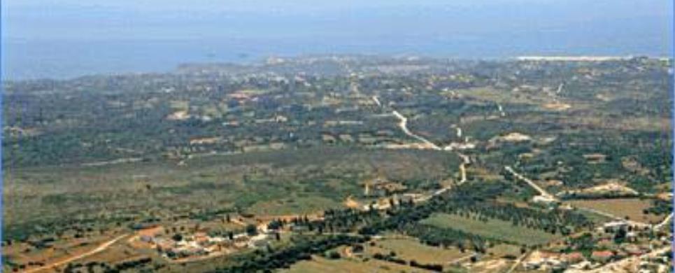
SVORONATA (Village) KEFALLONIA
Tel: +30 26710 41220
Svoronata is made up of three regions: Svoronata, Sarlata
and Domata. In the position
of the mediaeval capital of Kefalonia, Travliata, are the remains of the mediaeval
fortress. It was constructed in 1504, by Venetian and Cephalonian builders under
the supervision of the Italian engineer Nikolaos Tsimaras.
SYVOTA (Settlement) LEFKADA
A picturesque coastal village hiding in a sheltered cove, like a fjord. Because
the cove is extremely well protected from the elements, it is an ideal place for
mooring yachts. All around are the verdant hills. A short distance from Syvota
is Hirospilia, where Doerpfeld uncovered some neolithic finds. On the way from
from Poros to Syvota one can visit the villages of Fterno,
Vournikas, Sivros
and Agios Ilias. From
Agios Ilias one can follow a footpath to get to the summit of Mount Stavrota.
This text is cited December 2004 from the Ionian Islands Region General Secretariat URL below, which contains image
SYVROS (Village) LEFKADA
Tel: +30 26450 39379
Fax: +30 26450 39379
The whole of the Syvros region is full of a unique and varied beauty. Lower down
the olive trees prevail and as the altitude increases so do the plane trees. The
place has many waters and crops whilst old farmers describe how Syvros once had
the greatest number of watermills, 24 in total, to serve the needs of the local
population. Here and there can be spotted the springs of the Kerasia ravine, one
of the most beautiful on the island. All those who love rambling will soon be
able to enjoy walking along the paths which wind through the beautiful locale,
taking in the wonderful natural beauties as well as the delightful forest of Daphne.
The Karoucha cave, which is well worth a visit, is near Syvros
THINALIO (Municipality) CORFU
The Municipality of Thinali is located in the north of Corfu,
covering the flank of the Pantokrator
Mountain Massif as far as the sea, and comprises eight villages and 39 hamlets.
Its boundary to the north is the sea, where the beach stretches for
several kilometers from Roda
to Acharavi and Almiros,
Agios Spiridon, Apraos
and Kalamaki. It is considered to be one of the most extensive and cleanest beaches
in the Mediterranean, and in set in the scenery of exceptional natural beauty.
The coastal area of Thinali was one of the first in Greece
to develop for tourism, and all facilities one expects to find in a modern town
are available in the region’s centre, Acharavi,
with shops, restaurants, bars and banks supplying all services a tourist might
require.
(text: Hilary Whiton Paipeti)
This text (extract) is cited November 2003 from the Corfu
Villas & Apartments Federation tourist pamphlet (1996).
TSOUKALADES (Village) LEFKADA
Tel: +30 26450 97248
Fax: +30 26450 97248
Following the northwest route around the island, passing the pine
covered Faneromeni
monastery with its panoramic view of the Ionian
Sea, one comes to the village of Tsoukalades. A village which has harmoniously
interwoven tradition with modernity and offers peace and quiet as well as comfort.
In the area Tsoukalades is the marvelous beach of Pefkoulia where
the verdant pine trees literally touch the crystal clear sea and create a charming
picture; a picture, which liberates all the senses. An invitation to all those
who love exploration is the until now unexplored cave of Ai-Yiannis in the area.
It is also worth paying a visit to the area of the Primary School where the sunset
will charm even the most difficult visitor. In addition, a walk through the pine
wood of the village, alone or accompanied, is sure to leave all nature lovers
speechless.
This text (extract) is cited December 2003 from the Lefkada
Hoteliers Association tourist pamphlet (1998).
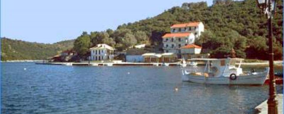
VASSILIKI (Village) LEFKADA
Vassiliki is in the centre of southern Lefkada.
A wonderful, classical, Greek fishing village ready to serve you on the edge of
the bay of the same name. Sandy beaches, endless, crystal clear waters, deep or
shallow are able to satisfy all needs. The area of Ponti
has been classed as on of the best world wide for windsurfing because of the peculiar
climatic conditions.
Crowned by overgrown slopes, the area offers the visitor a wonderful
sensation of nature as well as the chance to enjoy a number of activities such
ads horse riding and cycling. Ferries operate continuously to and from Porto Katsiki,
Agiofili, Cephalonia and Ithaki.
Vassiliki also has its own nightlife, which is equal to anything on offer from
the nightlife in Lefkada.
This text (extract) is cited December 2003 from the Lefkada
Hoteliers Association tourist pamphlet (1998).
VELONADES (Village) CORFU
Velonades is a village in the northwest of Corfu,
31 kilometres from Corfu Town.
It is located in verdant surroundings, near several lovely beaches, among them
Peroulades, Saint George and
Sidari.
The prime occupation of the 1860 inhabitants of the community is olive
cultivation and other agricultural activities, but during the summer they provide
services for visiting tourists. Rooms and houses are available for rent in this
traditional village, which also offers amenities such as bars and tavernas serving
local specialities.
The local people have preserved the traditions of the area, fro example
the famous festival of the Church of the Prophet Elias, which is held on the 20th
of July. The celebrations begin the evening before, and thousands of people, both
Corfiots from all over the island and foreigners, gather for the event.
Visitors who stay in Velonades are sure to enjoy the sheer tranquility
of the area, coupled with the warm hospitality of the local people.
(text: Hilary Whiton Paipeti)
This text (extract) is cited November 2003 from the Corfu
Villas & Apartments Federation tourist pamphlet (1996).
VIDO (Small island) CORFU
A green paint stroke escaped the painting of Corfu
and fell into the sea. Such was the creation of Vido Island, known since antiquity
by the name Ptychia or the island of Hera, referred to by Thucydides, Ptolemaeus
and other authors. Vido owes its present name to the French who occupied the island
in 1830.
With its sloping grounds, rocky coast, two wonderful beaches with
blue-green waters and a self-growing forest with extraordinary flora and rare
fauna, Vido presents a unique alternative for an unforgettable daylong excursion.
Situated at a distance of 1200 m from Corfu
town, it covers a surface of 550.000 square metres. The island can be accessed
by a boat, which leaves the Old Port at Spilia at regular hours. The completion
of Vidos’ development and promotion is one of the main targets ANEDK pursues.
The Municipality of Corfu has financed a series of important projects
on the island, like the restaurant (which can serve approximately 100 persons)
in idyllic surroundings, as well as two refreshment kiosks, one on each beach.
These facilities accommodate bathers, the young visitors staying at the Municipal
Camping Site every year and foreign guests of the Municipality of Corfu.
This text is cited May 2003 from the Corfu Municipality Development Enterprise URL below, which contains images.

Receive our daily Newsletter with all the latest updates on the Greek Travel industry.
Subscribe now!


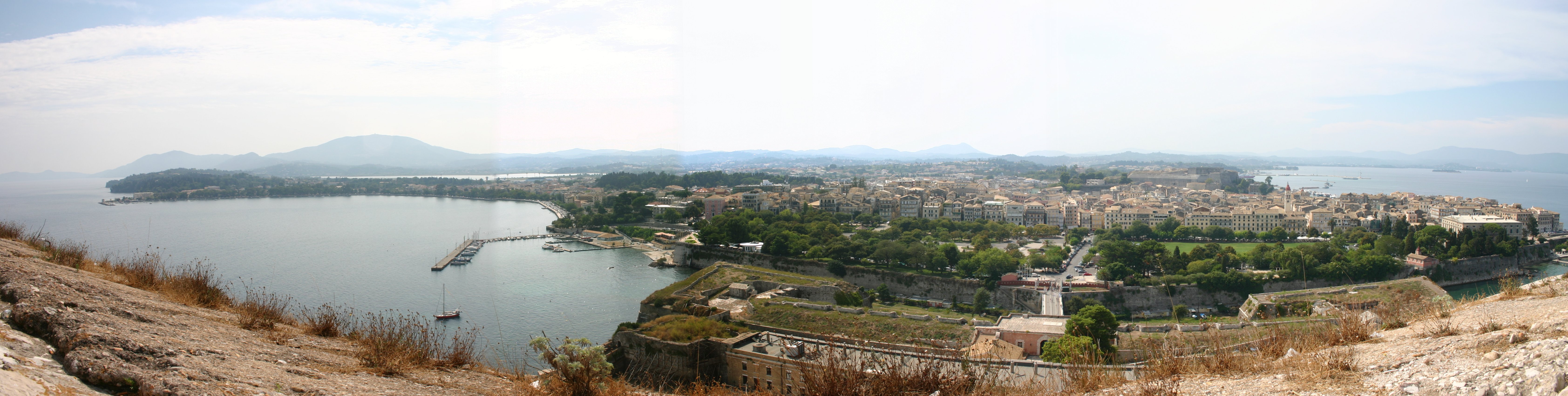
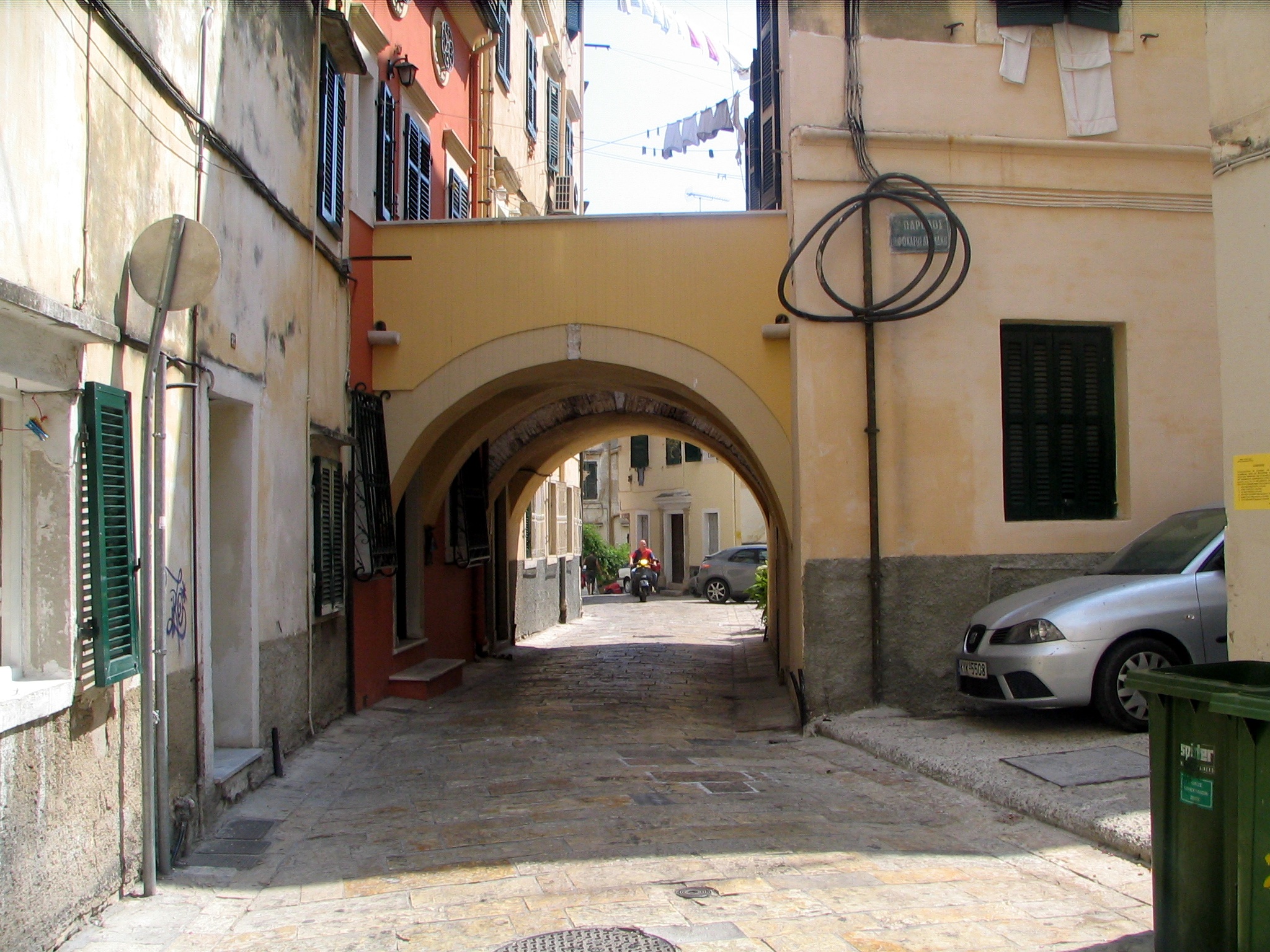
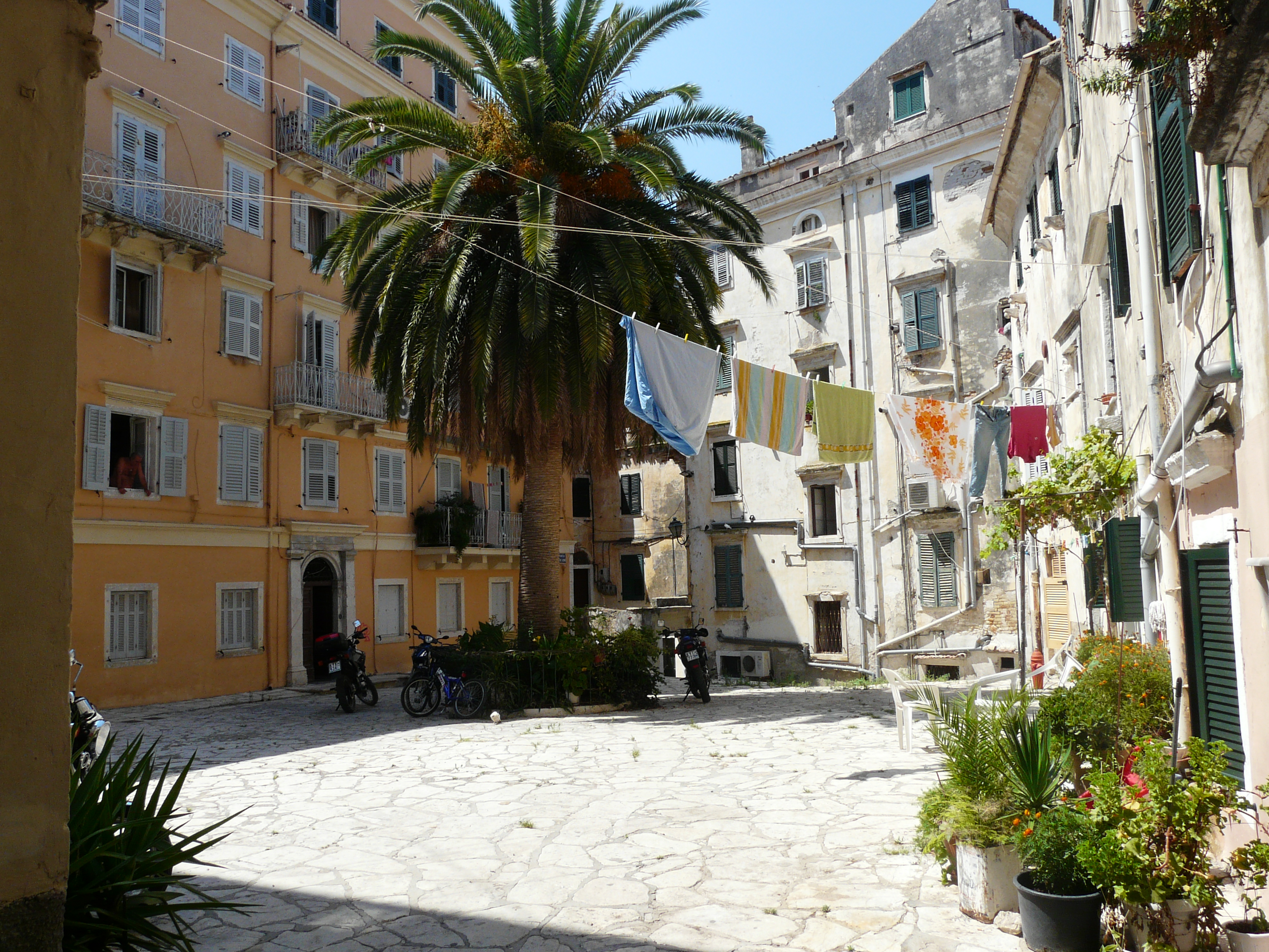
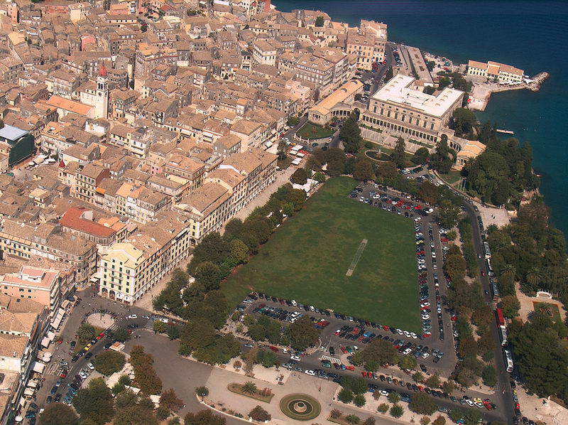
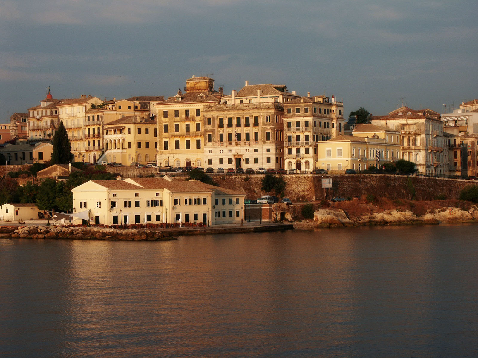
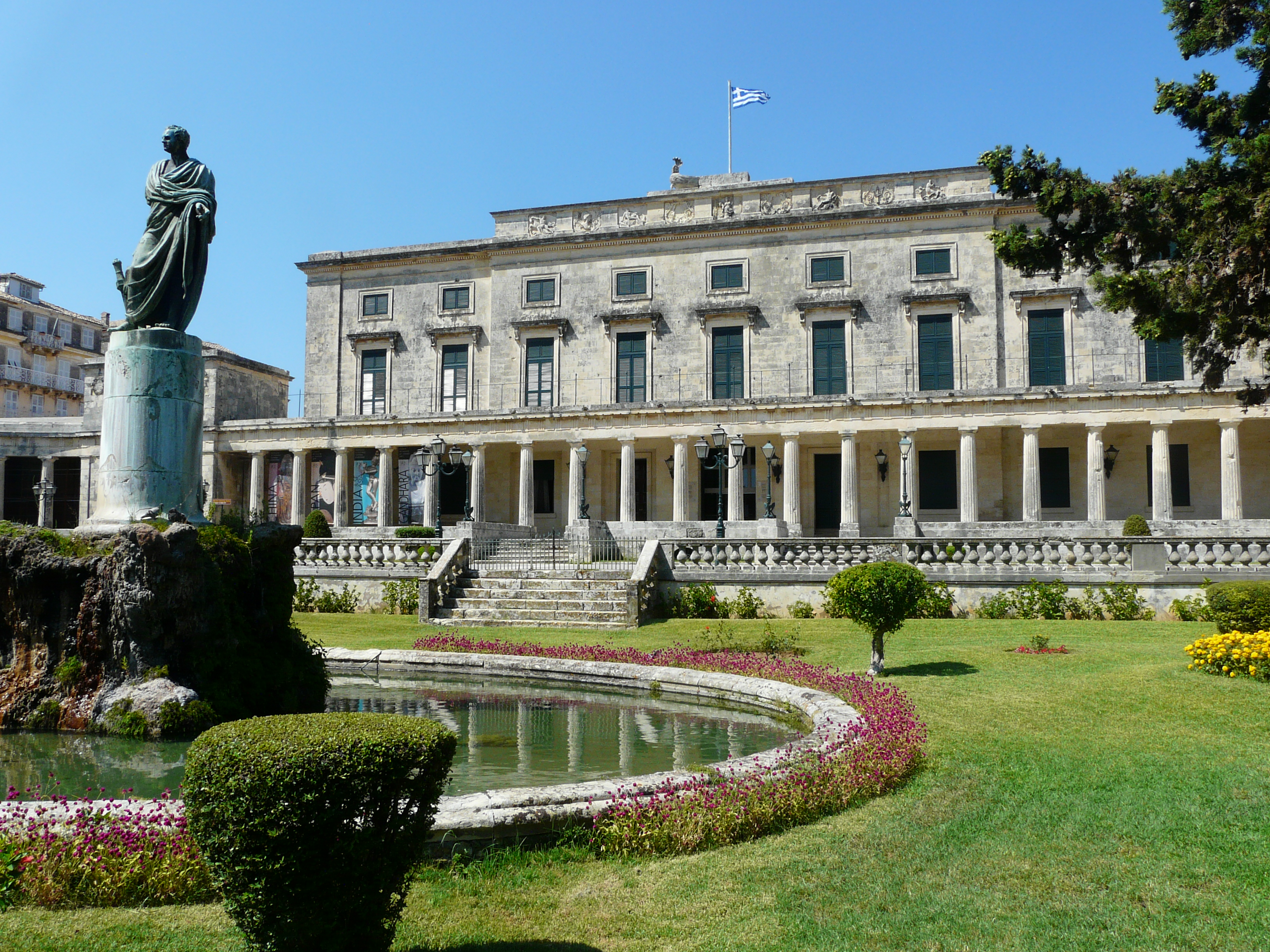
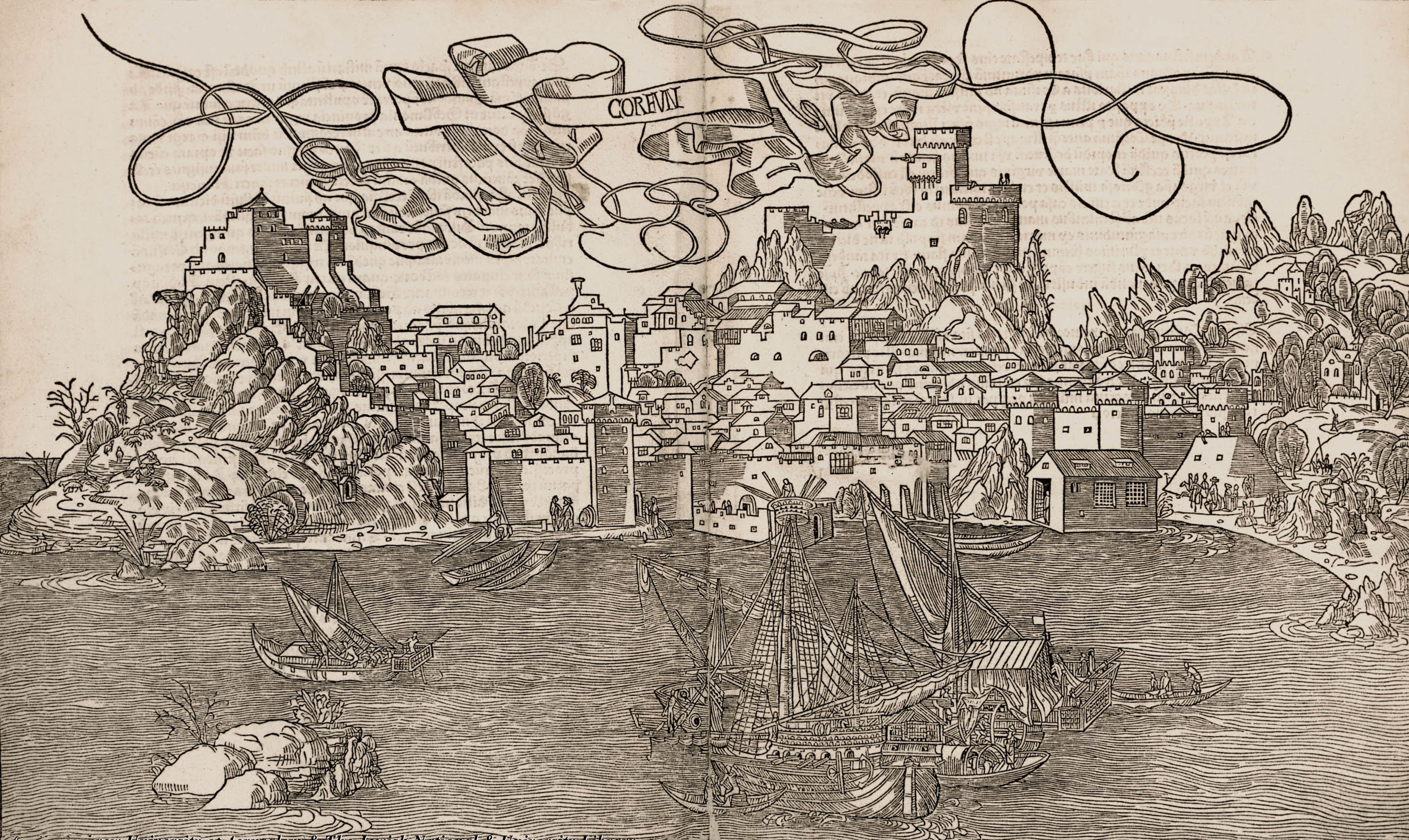
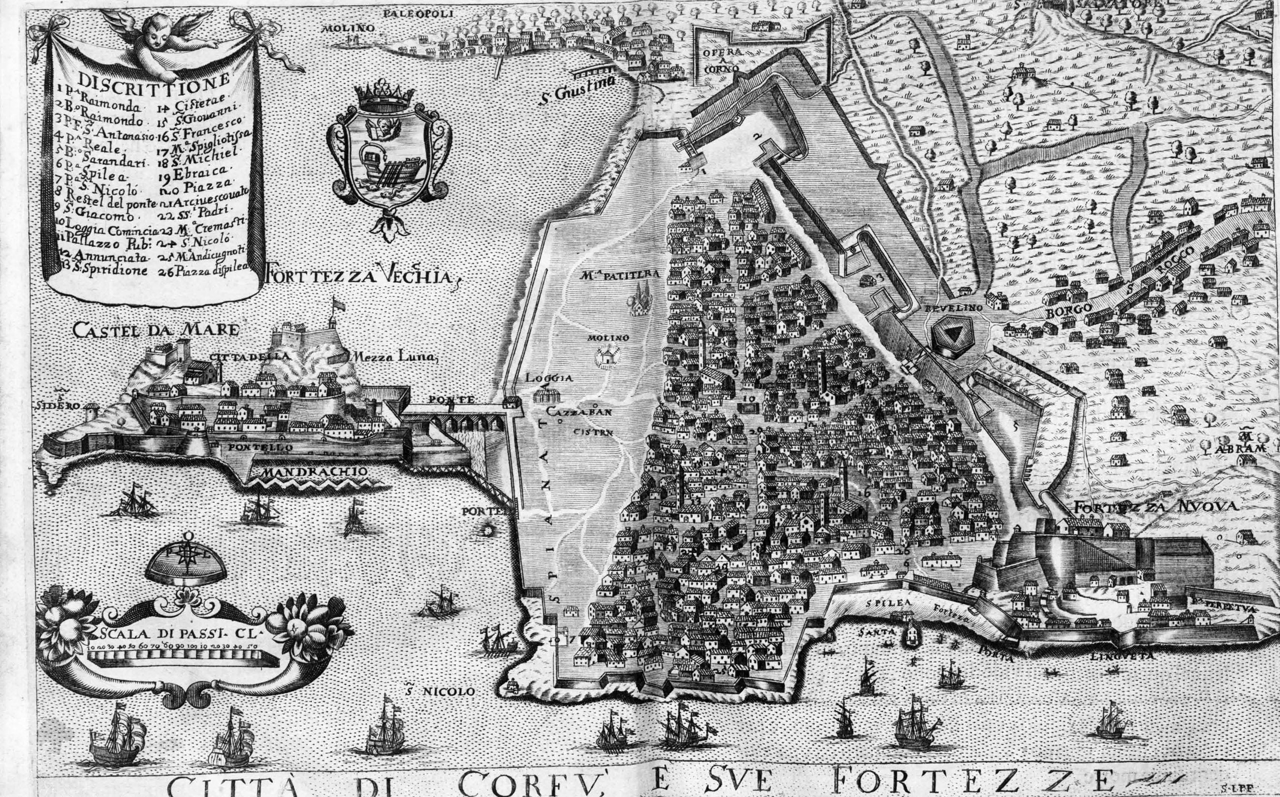
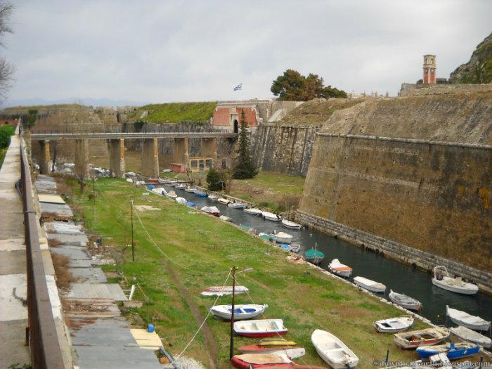
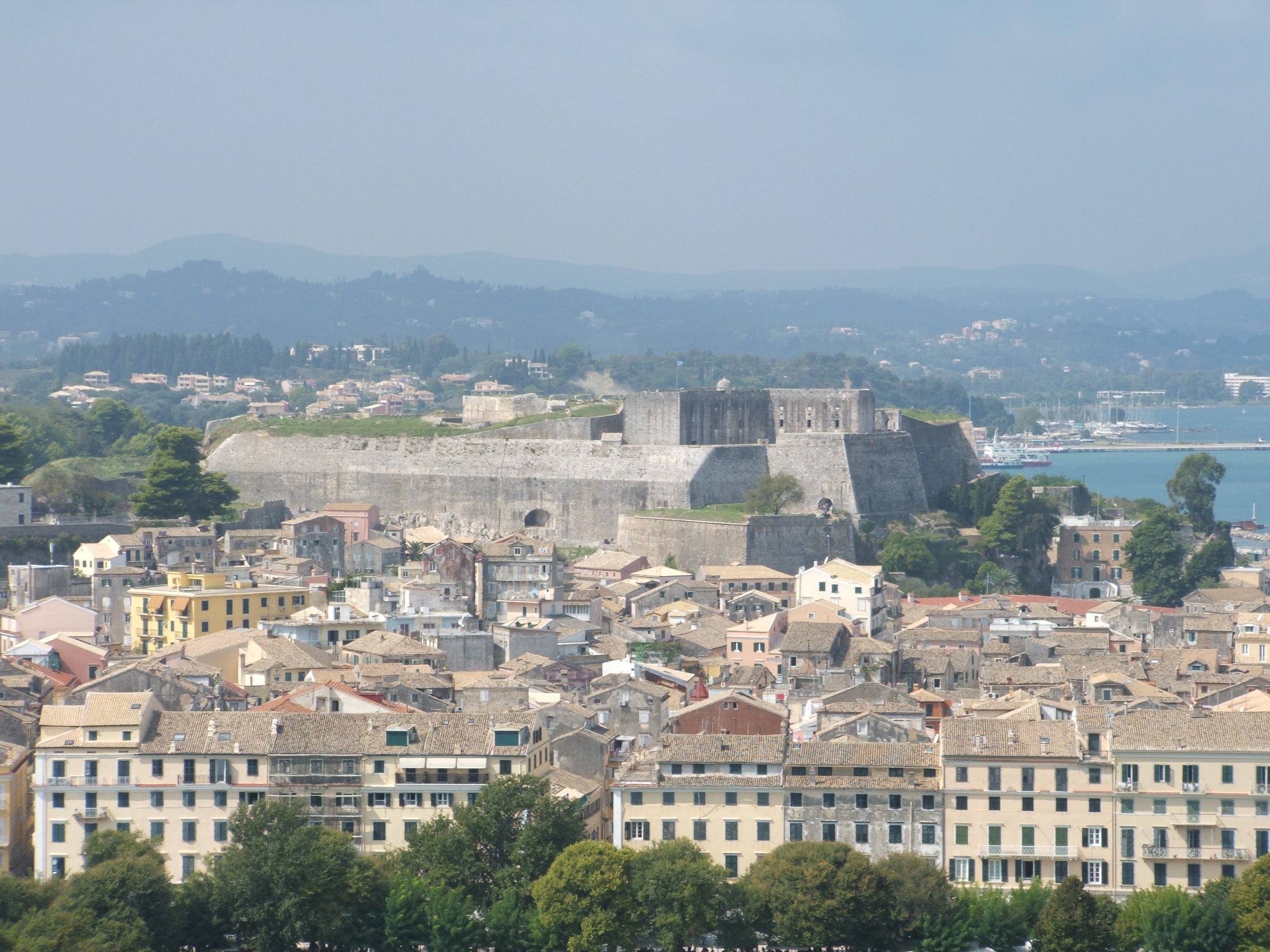
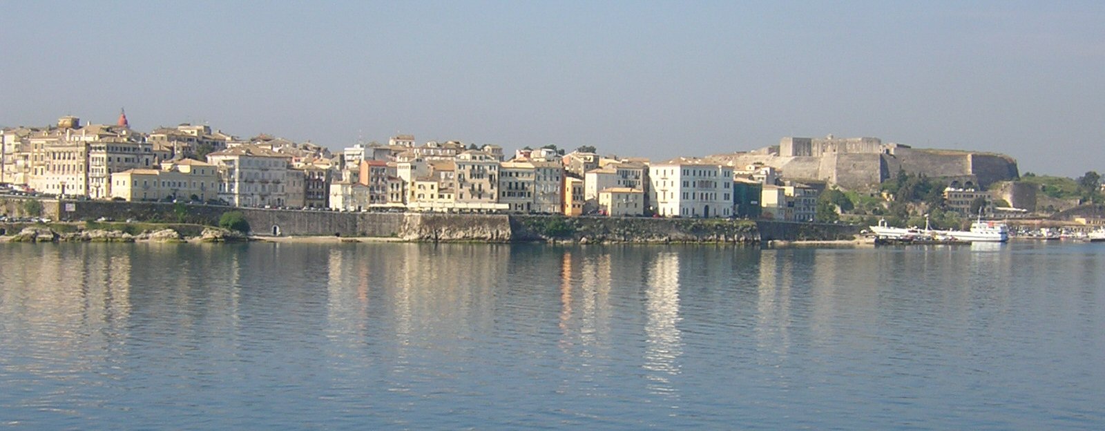