Listed 100 (total found 188) sub titles with search on: Information about the place for wider area of: "MUGLA Province TURKEY" .
Pages of the Turkish Ministry of Culture
ALIKARNASSOS (Ancient city) TURKEY
Halikarnassos: Eth. Halikarnasseus, Halicarnassensis: Bodrun or Boudroum),
a Greek city on the coast of Asia Minor, on the Ceramian gulf. It was a colony
of Troezene in Argolis established on the slope of a precipitous rock, and one
of the six towns constituting the Doric hexapolis in Asia Minor, the five other
towns. being Cnidos, Cos, and the three Rhodian towns Ialysus, Lindus, and Camirus.
(Herod. vii. 99, iii. 14; Strab. xiv. pp. 653, 656; Paus. ii. 30. § 8; Ptol. v.
2. § 10; Pomp. Mel. i. 16; Plin. v. 29; Steph. B. s. v.) The isthmus on which
it was situated was called Zephyrium, whence the city at first bore the name of
Zephyria. Halicarnassus was the largest and strongest city in all. Caria (Diod.
Sic. xv. 90), and had two or even three very impregnable arces; the principal
one, called Salmacis, was situated on a precipitous rock at the northern extremity
of the city [p. 1027] (Arrian, Anab. i. 23; Vitruv. ii. 8; Diod. xvii. 23, foll.),
and received its name from the well Salmacis, which gushed forth near a temple
of Aphrodite at the foot of the rock, and the water of which was believed to exercise
an enervating influence (Ov. Met. iv. 302). But Strabo justly controverts this
belief, intimating that the sensual enjoyments and the delicious character of
the climate must rather be considered to have produced the effects ascribed to
the Salmacis. Another arx was formerly believed to have been in the island of
Arconnesus in front of the great harbour, which is now called Orak Ada; but this
belief was founded upon an incorrect reading in Arrian. (Strab. l. c.; Arrian,
Anab. i. 23; Hamilton, Researches, ii. p. 34.) Besides the great harbour, the
entrance to which was narrowed by piers on each side, there was a smaller one
to the southeast of it. Halicarnassus, as already remarked, originally belonged
to the Doric hexapolis; but in consequence of some dispute which had arisen, it
was excluded from the confederacy. (Herod. i. 144.) During the Persian conquests
it was, like all the other Greek towns, compelled to submit to Persia, but does
not appear to have been less prosperous, or to have lost its Greek character.
While the city was under the dominion of the Persians, Lygdamis set himself up
as tyrant, and his descendants, as vassals of the kings of Persia, gradually acquired
the dominion of all Caria. Artemisia, the widow of Lygdamis, fought at Salamis
in the fleet of Xerxes. The most celebrated among their successors are Mausolus
and his wife and sister Artemisia, who, on the death of Mausolus, erected in his
honour a sepulchral monument of such magnificence that it was regarded as one
of the seven wonders of the ancient world. This Carian dynasty, though subject
to Persia, had themselves adopted Greek manners and the Greek language, and had
a taste for the arts of Greece. But notwithstanding this, Halicarnassus was faithful
to Persia, and was one of the great strongholds of the Persians on that coast,
and a chief station of the Persian forces. This, and the gallant defence with
which the Halicarnassians defended themselves against Alexander, induced that
conqueror, after a protracted siege, to destroy the city by fire. He was, however,
unable to take the acropolis Salmacis, in which the inhabitants had taken refuge.
(Strab. and Arrian, l. c.; Died. Sic. xvii. 23, foll.; Curtius, ii. 9, foll.)
From this blow Halicarnassus never recovered, though the town was rebuilt. (Cic.
ad Quint. Frat. i. 1) In the time of Tiberius it no longer boasted of its greatness,
but of its safety and freedom from earth-quakes. (Tac. Ann. iv. 55.) Afterwards
the town is scarcely mentioned at all, although the Mausoleum continued to enjoy
its former renown. (Const. Porph. de Them. i. 14; see the descriptions of it in
Plin. xxxvi. 9, and Vitruv. ii. 8.) The course of the ancient walls can still
be distinctly traced, and remains of the Mausoleum, situated on the slope of the
rock east of Salmacis, and of the arx, as well as the spring Salmacis, still exist.
(Hamilton's Researches, ii. pp. 34, foil.) Among the numerous temples of Halicarnassus,
one of Aphrodite was particularly beautiful. (Diod.; Vitruv. l. c.) To us the
city is especially interesting as the birthplace of two historians, Herodotus
and Dionysius. Some interesting sculptures, brought from Boudroum, and supposed
to have originally decorated the Mausoleum, are now in the British Museum.
This text is from: Dictionary of Greek and Roman Geography (1854) (ed. William Smith, LLD). Cited June 2004 from The Perseus Project URL below, which contains interesting hyperlinks

CHALKITORION (Ancient city) KARIA
Chalcetor (Chalketor: Eth. Chalketor), a place in Caria. Strabo (p.
636) says that the mountain range of Grion is parallel to Latmus, and extends
east from the Milesia through Caria to Euromus and the Chalcetores, that is, the
people of Chalcetor. The site of Chalcetor is not ascertained. In another passage
(p. 658) Strabo names the town Chalcetor, which some writers have erroneously
altered to Chalcetora; but the form Chalketoron (Strab. p. 636) is the Ethnic
name (Groskurd, Transl. of Strabo, vol. iii. p. 55).
Stephanus has a place Chalcetorium in Crete (s. v. Chalketorion);
unless we should read Caria for Crete.
DEDALA (Ancient city) TURKEY
Daedala (ta Daidala: Eth. Daidaleus), a city of the Rhodia, that is,
the Peraea in Caria, or a small place, as Stephanus B. says (s. v.), on the authority
of Strabo; and also a mountain tract in Lycia.
The eastern limit of the Rhodian Peraea was the town of Daedala, and
after Daedala, which belongs to the Rhodii, is a mountain of the same name, Daedala,
where commences the line of the Lycian coast: near the mountain, that is, on the
coast, is Telmissus, a town of Lycia, and the promontory Telmissis. (Strab. pp.
664, 665.) The Daedala is that part of the mountain country of Lycia which lies
between the Dalamon Tchy and the middle course of the Xanthus; and the high land
comes down to the coast at the head of the gulf of Glaucus or Makri. (Map, &c.
by Hoskyn, London Geog. Journal, vol. xii.) In Mr. Hoskyn's map just referred
to, the ruins of Daedala are placed near the head of the gulf of Glaucus, on the
west side of a small river named Inigi Chai, which seems to be the river Ninus,
of which Alexander in his Lyciaca (Steph. B. s. v. Daidala) tells the legend,
that Daedalus was going through a marsh on the Ninus, or through the Ninus river,
when he was bitten by a water snake, and died and was buried there, and there
the city Daedala was built. The valley through which the Ninus flows, is picturesque,
and well-cultivated. On the mountain on the W. side of the valley is an ancient
site, probably Daedala: here are numerous tombs hewn in the rocks in the usual
Lycian style; some are well-finished. The acropolis stood on a detached hill;
on its summits are remains of a well, and a large cistern. We did not find any
inscriptions. (Hoskyn.) But though no inscriptions were found, there is hardly
any doubt that the place is Daedala. Pliny (v. 31) mentions two islands off this
coast belonging to the Daedaleis. There is an island off the coast east of the
mouth of the Inigi Chai, and another west of the mouth of the river; and these
may be the islands which Pliny means. The islands of the Cryeis, three according
to Pliny, lie opposite to Crya, on the west side of the gulf of Makri. Livy (xxxvii.
22) mentions Daedala as a parvum castellum. Ptolemy (v. 2) places Daedala, and
indeed the whole of the west side of the gulf of Glaucus, in Lycia.
This text is from: Dictionary of Greek and Roman Geography (1854) (ed. William Smith, LLD). Cited September 2004 from The Perseus Project URL below, which contains interesting hyperlinks
EFTHINA (Ancient city) TURKEY
Euthenae (Euthenai: Eth. Euthenaios and Eutheneus), a town of Caria,
on the Ceramicus Sinus. (Plin. v. 29; Steph. B. s. v.)
EVROMOS (Ancient city) TURKEY
Euromus (Euroomos: Eth. Euromeus, a town in Caria, at the foot of
Mount Grion, which runs parallel with Latmus, was built by one Euromus, a son
of Idris, a Carian. (Strab. xiii. pp. 636, 658; Steph. B. s. v.; Polyb. xvii.
2; Liv. xxxii. 33, xxxiii. 30, xlv. 25.) Under the Roman dominion Euromus belonged
to the conventus of Alabanda. (Plin. v. 28.) Ruins of a temple to the north-west
of Alabanda are considered by Leake to belong to Euromus. (Asia Min. p. 237.)
FYSKOS (Ancient city) TURKEY
Physcus (Phuskos: Eth. Phuskeus), a town of Caria, in the territory
of the Rhodians, situated on the coast, with a harbour and a grove sacred to Leto.
(Strab. xiv. p. 652; Stadiasm. Mar. Mag. § 245; Ptol. v. 2. § 11, where it is
called Phouska.) It is impossible to suppose that this Physcus was the porttown
of Mylasa (Strab. xiv. p. 659); we must rather assume that Passala, the port of
Mylasa, also bore the name of Physcus. Our Physcus was the ordinary landing-place
for vessels sailing from Rhodes to Asia Minor. (Strab. xiv. p. 663; comp. Steph.
B. s. v.) This harbour, now called Marmorice, and a part of it Physco, is one
of the finest in the world, and in 1801 Lord Nelson's fleet anchored here, before
the battle of the Nile.
This text is from: Dictionary of Greek and Roman Geography (1854) (ed. William Smith, LLD). Cited August 2004 from The Perseus Project URL below, which contains interesting hyperlinks
IASSOS (Ancient city) TURKEY
Iassus or Iasus (Iasos: or Iasos: Eth. Iasseus), a town of Caria,
situated on a small island close to the north coast of the Iasian bay, which derives
its name from Iassus. The town is said to have been founded at an unknown period
by Argive colonists; but as they had sustained severe losses in a war with the
native Carians, they invited the son of Neleus, who had previously founded Miletus,
to come to their assistance. The town appears on that occasion to have received
additional settlers. (Polyb. xvi. 12.) The town, which appears to have occupied
the whole of the little island, had only ten stadia in circumference; but it nevertheless
acquired great wealth (Thucyd. viii. 28), from its fisheries and trade in fish
(Strab. xiv. p. 658). After the Sicilian expedition of the Athenians, during the
Peloponnesian war, Iassus was attacked by the Lacedaemonians and their allies;
it was governed at the time by Amorges, a Persian chief, who had revolted from
Darius. It was taken by the Lacedaemonians, who captured Amorges, and delivered
him up to Tissaphernes. The town itself was destroyed on that occasion; but must
have been rebuilt, for we afterwards find it besieged by the last Philip of Macedonia,
who, however, was compelled by the Romans to restore it to Ptolemy of Egypt. (Polyb.
xvii. 2; Liv. xxxii. 33; comp. Ptol. v. 2. § 9; Plin. v. 29; Stad. Mar. Magn.
§ § 274, 275; Hierocl. p. 689.) The mountains in the neighbourhood of Iassus furnished
a beautiful kind of marble, of a blood-red and livid white colour, which was used
by the ancients for ornamental purposes. (Paul. Silent. Ecphr. S. Soph. ii. 213.)
Near the town was a sanctuary of Hestias, with a statue of the goddess, which,
though standing in the open air, was believed never to be touched by the rain.
(Polyb. xvi. 12.) The same story is related, by Strabo, of a temple of Artemis
in the same neighbourhood. Iassus, as a celebrated fishing place, is alluded to
by Athenaeus (iii. p. 105, xiii. p. 606). The place is still existing, under the
name of Askem or Asyn Kalessi. Chandler (Travels in As. Min. p. 226) relates that
the island on which the town was built is now united to the mainland by a small
isthmus. Part of the city walls still exist, and are of a regular, solid, and
handsome structure. In the side of the rock a theatre with many rows of seats
still remains, and several inscriptions and coins have been found there. (Comp.
Spon and Wheler, Voyages, vol. i. p. 361.) A second town of the name of Iassus
existed in Cappadocia or Armenia Minor (Ptol. v. 7. § 6), on the north-east of
Zoropassus.
This text is from: Dictionary of Greek and Roman Geography (1854) (ed. William Smith, LLD). Cited September 2004 from The Perseus Project URL below, which contains interesting hyperlinks
KALYNDA (Ancient city) TURKEY
Calynda (Kalunda: Eth. Kalundeus), a town of Caria, according to Stephanus,
is placed by Strabo 60 stadia from the sea (p. 56), west of the Gulf of Glaucus,
and east of Caunus. The MSS. of Strabo appear to have Calymna, which, however,
is an error of the copyists. It appears, from a passage in Herodotus (i. 172),
that the territory of Caunus bordered on that of Calynda. Damasithymus (Herod.
viii. 87), king of Calynda, was at the battle of Salamis with some ships on the,
side of, Xerxes; from which we may conclude that Calynda was near the coast, or
had some sea-port. Calynda was afterwards, as it appears from Polybius (xxxi.
17), subject to Caunus; but having revolted from Caunus, it placed itself under
the protection of the Rhodians.
Fellows supposes Calynda to be under a range of mountains near the
sea, between two ridges of rocks; many large squared stones lie in heaps down
the slope facing the east, and the valley is guarded by walls of a very early
date, of Greek workmanship. He concludes, from the style of the tombs, that the
city was in Lycia. The place is near the gulf of Glaucus or Makri, and east of
the river Talaman-su. The remains which he saw are assigned to Daedala by Hoskyn.
(Spratt's Lycia, vol. i. p. 42.) But Fellows discovered a city which is proved
by inscriptions to be Cadyanda, a name otherwise unknown to us. It lies NNE. of
Makri, on the Gulf of Glaucus or Makri, at a place called Hoozoomlee, situated
on an elevated plain, immediately above which are the ruins of Cadyanda. There
are many rock tombs and sculptures, one of which is represented in the frontispiece
to Fellows' Lycia. The ruins of the city are seated on the level summit of a high
mountain; a, great street, bordered with temples and public buildings, runs down
the centre. (Spratt's Lycia.) Hoskyn, who discovered Caunus, looked in vain for
ruins between that place and Cadyanda. Accordingly, it is suggested that the mountains
of Hoozoomlee may be the Calyndian mountains. (Spratt's Lycia, vol. i. p. 43.)
But these Calyndian mountains are a modern invention, perhaps originating in a
misunderstanding of Herodotus (i. 132), who speaks of the Calyndian frontiers
(ouron ton Kalundikon). Between Hoozoomlee and Makri, a distance of about 9 miles,
there are no ruins; but in the centre of the plain of Makri there is a burial
ground, where some large inscribed blocks, apparently the remains of a building
which stood on the spot, have the name 'Cadyands' included in their inscriptions.
(Spratt's Lycia, vol. i. p. 44.) It is stated in another passage in this work
that the monumental inscription was found five or six miles south of Cadyanda.
The name Calynda occurs in Ptolemy (v. 3) as a Lycian city, and it
is the nearest Lycian city to Caunus in Caria. Pliny (v. 28) mentions Flumen Axon,
Oppidum Calynda. It is plain that Ptolemy's Calynda will not suit the position
of Cadyanda; nor can the position of Cadyanda be reconciled with Strabo's position
of Calynda. It is certain that Calynda is not Cadyanda. None of the inscriptions
of Cadyanda which are given by Fellows and in Spratt's Lycia are of an early period.
There is little or no doubt that Calynda is in the basin of the large river Talaman-Su,
which seems to be the Calbis of Strabo, and the same river that Pliny and Livy
call the Indus.
This text is from: Dictionary of Greek and Roman Geography (1854) (ed. William Smith, LLD). Cited August 2004 from The Perseus Project URL below, which contains interesting hyperlinks
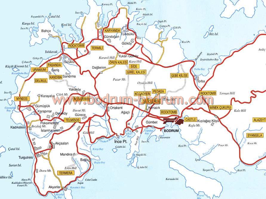
KARYANDA (Ancient city) TURKEY
Caryanda (Karuanda: Eth. Karuandeus). Stephanus (s. v. Karuanda) says
that Hecataeus, made the accusative singular Karuandan. He describes it as a city
and harbour (limen) near Myndus and Cos. But limen, in the text of Stephanus,
is an emendation or alteration: the MSS. have limne lake. Strabo places Caryanda
between Myndus and Bargylia, and he describes it, according to the common text,
as a lake, and island of the same name with it; and thus the texts of Stephanus,
who has got his information from Strabo, agree with the texts of Strabo. Pliny
(v. 31) simply mentions the island Caryanda with a town; but he is in that passage
only enumerating islands. In another passage (v. 29) he mentions Caryanda as a
place on the mainland, and Mela (i. 16) does also. We must suppose, therefore,
that there was a town on the island and one on the mainland. The harbour might
lie between. Scylax, supposed to be a native of Caryanda, describes the place
as an island, a city, and a port. Tzschucke corrected the text of Strabo, and
changed limne into limen: and the last editor of Stephanus has served him the
same way, following two modern critics. It is true that these words are often
confounded in the Greek texts; but if we change limne into limen in Strabo's text,
the word tauthe, which refers to limne, must also be altered. (See Groskurd's
note, Transl. Strab. vol. iii. p. 53.)
Leake (Asia Minor, p. 227) says there can be little doubt that the
large peninsula, towards the westward end of which is the fine harbour called
by the Turks Pasha Limani, is the ancient island of Caryanda, now joined to the
main by a narrow sandy isthmus. He considers Pasha Limani to be the harbour of
Caryanda noticed by Strabo, Scylax, and Stephanus. But it should not be forgotten
that the texts of Strabo and Stephanus speak of a limne, which may mean a place
that communicated with the sea. The supposition that the island being joined to
the main is a remote effect of the alluvium of the Maeander, seems very unlikely.
At any rate, before we admit this, we must know whether there is a current along
this coast that runs south from the outlet of the Maeander.
Strabo mentions Scylax the ancient writer as a native of Caryanda,
and Stephanus has changed him into the ancient logographus. Scylax is mentioned
by Herodotus (iv. 44): he sailed down the Indus under the order of the first Darius
king of Persia. He may have written something; for, if the Scylax, the author
of the Periplus, lived some time after Herodotus, as some critics suppose, Strabo
would not call him an ancient writer.
This text is from: Dictionary of Greek and Roman Geography (1854) (ed. William Smith, LLD). Cited August 2004 from The Perseus Project URL below, which contains interesting hyperlinks
KAVNOS (Ancient city) TURKEY
Caunus (he KauWos: Eth. KauWios and KauWaios), a city of Caria, in
the Peraea. Strabo places Caunus west of Calynda. Caunus had dockyards and a closed
harbour, that is, a harbour that could be closed. Above the city, on a height,
was the fort Imbrus. Diodorus (xx. 27) mentions two forts, Persicum and Heracleium.
The country was fertile, but unhealthy in summer and autumn, owing to the air
and the abundance of fruit, of which we must suppose the people ate too much,
as the fruit alone could not cause unhealthiness. Strabo's description of the
position is not clear. After mentioning Calynda, he says, then Caunus, and a river
near it, Calbis, deep, and having a navigable entrance, and between, Pisilis;
which means that Pisilis is between the Calbis and Caunus. It is clear, then,
that Caunus, according to Strabo, is not on the Calbis, as it is represented in
some maps. If the Calbis, which is the Indus, or the large river Dalamon Tchy,
is east of Pisilis, it is of course still further east of Caunus. Caunus is placed
in some maps a little distance south of a lake on a stream which flows from it,
and four or five miles from the sea; but the river is usually incorrectly marked
the Calbis. The site of Caunus is said to be now Kaiguez, or some similar name.
But the ancient descriptions of the site of Caunus vary. Mela (i. 16) places Caunus
on the Calbis. Ptolemy (v. 2) places it east of the Calbis, and his description
of the coast of Caria is exact. But as he mentions no other river except the Calbis
till we come to the Xanthus, he has omitted the Dalamon Tchy, unless this is his
Calbis. Pliny (v. 28), who proceeds from east to west in his description of this
part of the coast, mentions the great river Indus, supposed to be the Calbis,
and then Oppidum Caunus liberum. This confusion in the ancient authorities cannot
be satisfactorily cleared by the aid of any modern authorities. This part of the
coast seems to have been very imperfectly examined. Kiepert places Caunus on the
west side of the entrance of Portus Panormus.
Herodotus (i. 172) says that the habits of the Caunii were very different
from those of the Carians and other people. It was their fashion for men, women,
and children to mingle in their entertainments. They had once some foreign deities
among them, but they expelled them in singular fashion. The Caunii made a desperate
resistance to the Persian general Harpagus, like their neighbours the Lycians.
(Herod.i. 176.) The Caunii also joined the Ionians in their revolt against the
Persians after the burning of Sardis, B.C. 499. (Herod. v. 103.) When Thucydides
(i. 116) speaks of the expedition of Pericles to the parts about Caunus after
the seafight at the island of Tragia (B.C. 440), he says, he went towards Caria
and Caunus, as if he did not consider Caunus to be included in Caria Proper. The
place is mentioned several times in the eighth book of Thucydides, and in one
passage (viii. 39) as a secure harbour against attack. As Caunus was in the Rhodian
Peraea, it belonged to the Rhodians, but the islanders were not always able to
hold it. There is a story recorded in Polybius (xxxi. 7) of the Rhodians having
bought Caunus from the generals of Ptolemaeus for 200 talents; and they alleged
that they had received, as a grant from Antiochus the son of Seleucus, Stratoniceia
in Caria. Caunus was taken by Ptolemy in B.C. 309 (Diod. xx. 27), and the Rhodians
may have bought it of him. A decree of the Roman senate ordered the Rhodians to
take away their garrisons from Stratoniceia and Caunus. (Polyb. xxx. 19.) This
was in B.C. 167. (Liv. xlv. 25.) The Romans appear to have given Caunus, with
other places in Caria, to the Rhodians, after the defeat of Antiochus in Asia.
(Liv. xxxvii. 56.) For Appian says that in the massacre of the Romans in Asia,
which was planned by Mithridates Eupator, the Caunii, who had been made tributary
to the Rhodians after the war with Antiochus (B.C. 190), and had been set free
by the Romans not long before (B.C. 167), dragged out the Italians who had fled
for refuge to the Boulaea Hestia, or the hearth of Vesta, in the senate house,
and after murdering the children before the eyes of their mothers, they killed
the mothers and the husbands on the dead bodies. (Appian, Mithrid. c. 23.) This
dreadful massacre happened in B.C. 88; and Sulla, after defeating Mithridates,
repaid the Caunii by putting them again under their old masters the Rhodians.
Strabo says that the Caunii once revolted from the Rhodians, and the case being
heard by the Romans, they were brought back under the Rhodians; and there is an
extant oration of Molo against the Rhodians. Apollonius Molo was in Rome, B.C.
81, as an ambassador from the Rhodians, and this seems to be the occasion to which
Strabo refers (Cic. Brut. 90), and which is by some critics referred to the wrong
time. Cicero (ad Q. Fr. i. 1. § 11) speaks of the Caunii as being still subject
to the Rhodians in B.C. 59; but they had lately applied to the Romans to be released
from the Rhodian dominion, and requested that they might pay their taxes to the
Romans rather than to the Rhodians. Their prayer had not been listened to, as
it seems, for they were still under the Rhodians. Though Cicero says lately (nuper)
he may be speaking of the same event that Strabo mentions. When Pliny wrote, they
had been released from the tyranny of the islanders, for he calls Caunus a free
town.
Caunus was the birthplace of one great man, Protogenes the painter,
who was a contemporary of Apelles, and therefore of the period of Alexander the
Great; but he lived chiefly at Rhodes. Pliny (xxxv. 10) speaks of his birthplace
as a city subject to the Rhodians; and though we cannot use this as historical
evidence, Caunus may have been subject to the Rhodians at that time. Caunus was
a place of considerable trade, and noted for its dried figs (Plin. xv. 19), a
fruit that would not contribute to the unhealthiness of the place, even if the
people eat them freely. They seem to have been carried even to Italy, as we may
infer from a story in Cicero (de Divin. ii. 40).
This text is from: Dictionary of Greek and Roman Geography (1854) (ed. William Smith, LLD). Cited August 2004 from The Perseus Project URL below, which contains interesting hyperlinks
KEDRIES (Ancient city) TURKEY
Cedreae (Kedreai, Kedreiai: Eth. Kedreates. Kedraios), a city of Caria,
mentioned by Hecataeus. (Steph. s. v. Kedreai.) Lysander took the place, it being
in alliance with the Athenians. The inhabitants were michobarbaroi, a mixture
of Greeks and barbarians, as we may suppose. It was on the Ceramicus gulf in Caria;
but the site is unknown. (Xen. Hell. ii. 1. 15)
KNIDOS (Ancient city) TURKEY
Cnidus (Knidos, Cnidus: Eth. Knidios), a city in Caria, at the western
extremity of a long peninsula, which forms the southern side of the bay called
Ceramicus. Strabo describes Cnidus accurately: it has two ports, one of which
can be closed, and is intended for triremes, and it has a station for twenty ships;
there lies in front of the city an island about seven stadia in circuit, lofty,
in the form of a theatre, joined by a causeway to the mainland, and making Cnidus
in a manner two cities, for a large part of Cnidus is on the island, which covers
both the harbours. This island, now called Cape Krio, is united to the main by
a sandy isthmus. The island is about 600 yards long, with an average width of
about 150 yards. Strabo's dimensions are pretty near the mark. On the west side
towards the sea the island is steep in some parts, and it slopes down eastward
towards the two harbours, which gives it the appearance that Strabo mentions.
On each side of the isthmus there is an artificial harbour; the smallest (on the
north side) has a narrow entrance between high piers, and was evidently the closed
basin for triremes which Strabo mentions. The southern and largest port is formed
by two transverse moles; these noble works were carried into the sea to the depth
of nearly a hundred feet; one of them is almost perfect; the other, which is more
exposed to the south-west swell, can only be seen under water. (Beaufort, Karamania,
p. 81.) A few yards from the end of the west pier there is very deep water at
the entrance of the southern harbour: it is marked 17 fathoms in Beaufort's plan.
The water shoals from the entrance of each harbour to the sandy isthmus which
connects Cape Krio with the mainland, and the Cnidians doubtless found no great
depth of water between the island and the main when they constructed their causeway.
Pausanias, who wrote after Strabo, in two different passages (viii. 30. § 2; v.
24. § 7), says that the island of Cnidus was separated from the mainland by a
narrow channel, which he calls Euripus; and in one of the passages he says that
there was a bridge over it. He adds that the chief part of the city is on the
mainland of Caria, as he calls it, and most of the chief buildings. There is perhaps
no inconsistency between Strabo and Pausanias, for if there was a bridge, there
was probably a causeway too.
The site of Cnidus is covered with ruins in every direction, particularly
on the NE. side of the harbour. To the SW. are the remains of an ancient quay,
supported by Cyclopian walls, and in some places cut out of the steep limestone
rocks, which rise abruptly from the water's edge. (Hamilton; Researches, &c. vol.
ii. p. 39.). Hamilton found the walls of Cnidus very perfect, and traced them
throughout their whole extent to the east of the harbour. The city is enclosed
by two walls, one running east and west, the other almost north and south, and
united at the summit of the hill to the NE. of the town; the former is partly
Cyclopian, and partly pseudisodomous, but the style improves as it ascends. The
northern part of the wall is very perfect, and contains two or three towers in
a state of great preservation; it is also the best constructed, being probably
of a later date and purely isodomous. The walls in the peninsula are also well
preserved, containing a round tower of great beauty at the extremity, near the
northern harbour. (Hamilton.) No ancient city has been more mercilessly plundered
than Cnidus; its proximity to the sea may account for its present condition. There
are two theatres, one of which had a diameter of 400 feet, both in a ruined condition,
a Doric stoa, and the basement of a large building which may have been a temple.
The two theatres were on the mainland side. On the site of the town there are
circular or pear-shaped holes in the ground covered with cement, which must have
been cisterns, as Hamilton supposes, for holding rain water; for there is neither
stream nor fountain anywhere near. Cnidus contains examples of Greek architecture
of different kinds, both Doric and Ionic. The drawings of the most important remains
are published in the Ionian Antiquities of the Dilettanti Society. (From Beaufort's
Karamania.)
About a mile or more from the eastern gate of Cnidus are numerous
tombs, some of which are buildings of considerable extent. One of the largest
is a square of 120 feet, with walls of beautiful polygonal construction and a
regular coping of flat slabs; within this space are two or three small buildings,
apparently tombs. (Hamilton.) The front wall of these tombs is in some few cases
built in horizontal courses, but the polygonal blocks are most frequent. In the
interior there are either arched vaults or narrow passages covered with flat stones;
the vaults are either formed of large Cyclopian blocks, or of small stones firmly
cemented together. (Hamilton.) The existence of Cyclopian masonry, Mr. Hamilton
observes, thus intimately connected with regular arches, seems to prove that the
polygonal style must have been in use at a much later period than is usually believed.
He further says, that this Cyclopian masonry, as it is called, is not decisive
evidence of the great antiquity of a building; and few good critics will dispute
the truth of this remark now. An inscription was found among these Cyclopian tombs
which belongs to the Roman period.
The extreme western point of the Cnidian peninsula was the Triopium
Promontorium, as Scylax calls it, now Cape Krio, and perhaps Herodotus (i. 174)
limits the name Triopium to this promontory. But the territory of Cnidus (he Knidia)
extended eastward to Bubassus at the head of the gulf of Syme, and here is the
narrow isthmus which the Cnidians attempted to cut through in the time of Cyrus
the Persian. This long narrow peninsula is about 40 miles in length, and its greatest
width about 10 miles. It does not seem to have been accurately examined by any
modern traveller, but we know its form now from the late British survey. Herodotus
certainly calls all this peninsula the Cnidia, and he describes it more clearly
than any other writer. Pliny (v. 28) is very brief and confused; perhaps he gives
the name Triopia to the small peninsula, or he may include in this term the western
part of the whole peninsula. His term Doris may perhaps include the whole peninsula.
Pausanias (i. 1. § 3) has no name for it, unless it be the Carian Chersonesus,
for he speaks of Cnidus as being in the Carian Chersonesus; but in another passage
(v. 24. § 7) he clearly gives the name Chersonesus only to the island,which is
now Cape Krio, and he says that the chief part of Cnidus is built on the Carian
mainland. As the narrow isthmus which the Cnidians attempted to cut through is
at the eastern extremity of the peninsula, it is a fair conclusion that all the
part west of the isthmus belonged to the Cnidii; and as there is no other city
to whose territory it could conveniently be attached, it seems a certain conclusion
that they had the whole of the peninsula. Cnidus is mentioned in one of the so-called
Homeric hymns, but we can conclude nothing from this. It was a Lacedaemonian colony,
and the leader of the colony according to tradition was Triopas. (Pans. x. 11.
§ 1.) It was one of the members of the Dorian Hexapolis, which was reduced to
five cities after the exclusion of Halicarnassus. (Herod. i. 144.) These Dorian
colonies, Cnidus, Cos, and Lindus, Ialysus and Camirus in Rhodes, formed a confederation.
Their place of meeting was at the temple of the Triopian Apollo, where they had
games, and bronze tripods for prizes. The site of the Triopian temple was on the
island, now Cape Krio. (Thucyd. viii. 35.) The Cnidians traded to Egypt at an
early period (Herod. ii. 178); and they had a treasury at Delphi (Paus. x. 11.
§ 5). The position of the place was favourable for trade, and. Cnidus acquired
wealth. They colonised Lipara, one of the Aeolian islands off the north coast
of Sicily. After their unsuccessful attempt to cut. across their isthmus, the
Cnidians surrendered to Harpagus, the general of Cyrus the Persian, and so far
as we know they remained quiet. At the commencement of the Peloponnesian War they
were dependents on Athens, for we must suppose that Thucydides (ii. 9) includes
them in the term Dorians dwelling close to the Carians. Cnidus deserted the Athenians
after their losses in Sicily, and the Athenians made an unsuccessful attempt to
seize the place. Thucydides (viii. 35), after speaking, of the Athenians surprising
some vessels at the Triopian promontory, says that they then sailed down upon
Cnidus, and attacking the city, which was unwalled, nearly took it. The city is
evidently the town on the mainland, and as this city was then unwalled, the walls
which Hamilton describes must be of later date than the Peloponnesian War. In
B.C. 394 Conon, who commanded a Persian and. Hellenic fleet, defeated the Lacedaemonians
under Pisander off Cnidus and destroyed the supremacy of Sparta. (Xen. Hell. iv.
3. 10; Isocrates, Panegyr. c. 39.)
In the war of the Romans with Antiochus the Cnidii readily obeyed
the orders of the Romans. (Liv. xxxvii. 16.) One of the very few occasions on
which anything is recorded of the military operations of the Cnidii is their sending
relief to Calynda, when it had revolted from Caunus (Polyb. xxxi. 17),. about
B.C. 163. On the settlement of the province of Asia they were included in it,
and in Pliny's time Cnidus was Libera, and probably at an earlier time. It was
taken by the pirates who infested these seas before they were cleared out by Cn.
Pompeius B.C. 67 (Cic. Pro Lege Manilia, c. 12), at the same time that Samos,
Colophon and other places on the coast were plundered.
Hamilton (Researches and Appendix, vol. ii.) copied several inscriptions
at Cnidus. None of them are ancient, and most of them belong to the Roman period.
The Doric form appears in damos and other words. The name of Apollo Carneius occurs
in one inscription; and Apollo was worshipped under this name at Corinth, and
by all the Dorians (Paus. iii. 13. § 4). This inscription is a memorial in honour
of Caius Julius Theopompus (Theupompus in the inscription) the son of Artemidorus
(as it stands in Hamilton's copy), and it was erected by his friend Marcus Aephicius
Apollonius, the son of Marcus. There was a Theopompus, a native of Cnidus, an
historical writer and friend of the dictator Caesar (Strab. p. 656); and Theopompus
had a son Artemidorus, but according to this inscription Theopompus, was the son
of Artemidorus. An Artemidorus informed Caesar of the conspiracy against him.
(Plut.. Caes. c. 65.) The inscription shows that Theopompus was a Greek who had
after Greek fashion taken the praenomen and nomen of his patron, and this Theopompus
may have been the man whom the dictator patronised. Hamilton conjectures that
Apollonius may be Molon, the rhetorician, the teacher of Caesar, and Cicero; but
if that is so, his father must have received the Roman citizenship, for he is
called: Marcus in the inscription.
Eudoxus the mathematician, as Strabo calls him, one of the friends
of Plato, was a native of Cnidus; but he is chiefly known as an astronomer. Strabo
(p. 119, 806) speaks of his observatory (skope) at Cnidus, from which he saw the
star Canopus: his observatory was not much higher than the houses. Ctesias, a
physician, and the author of a Persian history, was a native of Cnidus; and also
Agatharchides, who wrote a treatise on the Erythraean sea and other works. The
Cnidians were fond of art, though the city did not produce artists. They placed
a statue of Jupiter at Olympia, with a statue of Pelops on one side of it, and
the river Alpheius on the other. (Paus. v. 24. § 7.) They also set up at Delphi
a statue of Triopas, the so-called founder of their city, a figure of a man standing
by a horse; and a Leto, and Apollo and Artemis, shooting their arrows at Tityus.
(Paus. x. 11. § 1.) The painting of Polygnotus, at Delphi, called Lesche, was
an offering of the Cnidii. (Paus. x. 25. § 1.) Aphrodite was worshipped at Cnidus,
and the place was supposed to be one of her favourite abodes. (Hor. Od. i. 30;
iii. 28.) Pausanias mentions three temples of Aphrodite at Cnidus; in the oldest
she was worshipped as Doritis, in a second as Acraea, and in the third and most
recent as Cnidia, or, as the Cnidians called her, Euploea, the deity of mariners
(i. 1. § 3). Cnidus possessed the statue of the naked Aphrodite of Praxiteles,
of Parian marble, one of the great works of Grecian genius. The statue stood in
a chamber with two doors, so that the figure could be seen on both sides. People
used to visit Cnidus to see the beautiful goddess. (Plin. xxxvii. 5.) Nicomedes,
king of Bithynia, offered to buy this precious work from the Cnidians by paying
the whole of the public debt of Cnidus, which was large, but the Cnidians preferred
to keep their goddess and their debt. Lucian, (Amor. c. 11, &c.), or the author
of the little piece that is printed in Lucian's works, has described the statue
with the feeling of an artist. (Dict. of Biogr. art. Praxiteles, where the various
passages are referred to.)
The coins of Cnidus have the epigraph kni and knidian.
This text is from: Dictionary of Greek and Roman Geography (1854) (ed. William Smith, LLD). Cited August 2004 from The Perseus Project URL below, which contains interesting hyperlinks
LAGINA (Ancient city) TURKEY
Lagina (ta Lagina), a place in the territory of Stratoniceia, in Caria,
contained a most splendid temple of Hecate, at which every year great festivals
were celebrated. (Strab. xiv. p. 660.) Tacitus (Ann. iii. 62), when speaking of
the worship of Trivia among the Stratoniceians, evidently means Hecate. The name
of Lagina is still preserved in the village of Lakena, not far from the sources
of the Tshina. Laginia, mentioned by Steph. B. as a polichnion Karias, seems to
be the same as the Lagina of Strabo.
This text is from: Dictionary of Greek and Roman Geography (1854) (ed. William Smith, LLD). Cited July 2004 from The Perseus Project URL below, which contains interesting hyperlinks
LAVRANDA (Ancient sanctuary) TURKEY
Labranda (ta Labranda or Labraunda), a village in the west of Caria,
about 60 stadia from the town of Mylasa, to which the village belonged, and with
which it was connected by a road called the sacred. Labranda was situated in the
mountains, and was celebrated for its sanctuary of Zeus Stratios, to which processions
went along the sacred road from Mylasa. Herodotus describes (v. 119) the sanctuary
as an extensive grove of plane trees, within which a body of Carians, in their
war against the Persians, retreated for safety. Strabo (xiv. p. 659) speaks of
an ancient temple with a xoanon of Zeus Stratios, who was also surnamed Labrandenus
or. Labrandeus. Aelian (H. A. xii. 30), who states that the temple of Labranda
was 70 stadia from Mylasa, relates that a spring of clear water, within the sanctuary,
contained fishes, with golden necklaces and rings. Chandler (Antiq. of Ionia,
pt. 1. c. 4, and Asia Minor, c. 58) was the first who stated his belief, that
the ruins at Iakli, south of Kizeljik, consisting of a theatre and a ruined temple
of the Ionian order, of which 16 columns, with the entablature, were then still
standing, were those of ancient Labranda and of the temple of Zeus Stratios. But
Choiseul Gouffier, Barbie du Bocage, and Leake (Asia Minor, p. 232), agree in
thinking that these ruins belong to Euromus rather than Labranda. Their view is
supported by the fact that the ruins of the temple have nothing very ancient about
them, but rather show that they belong to a structure of the Roman period. The
remains of Labranda must be looked for in the hills to the north-east of Mylasa.
Sir C. Fellows (Journal, p. 261), apparently not knowing what had been done by
his predecessors, unhesitatingly speaks of the ruins at Iakli as those of Labranda,
and gives an engraving of the remains of the temple under the name of the Temple
at Labranda.
This text is from: Dictionary of Greek and Roman Geography (1854) (ed. William Smith, LLD). Cited July 2004 from The Perseus Project URL below, which contains interesting hyperlinks
LORYMA (Ancient city) TURKEY
Loryma (ta Loruma), a small fortified place with a port, close to
Cape Cynossema, on the western-most point of the Rhodian Chersonesus, in Caria.
Its harbour was about 20 Roman miles distant from Rhodes. (Liv. xxxvii. 17, xlv.
10 ; Steph. B. s. v.; Plin. v. 29; Ptol. v. 2. § 11; Thucyd. viii. 43; Senec.
Quaest. Nat. iii. 19 ; Appian, Bell. Civ. iv. 72.) Strabo (xiv. p. 652) applies
the name Loryma to the whole of the rocky district, without mentioning the town.
The Larumna of Mela (i. 16) and the Lorimna of the Tab. Peut. perhaps refer to
Loryma, although it is also possible that they may be identical with a place called
Larymna mentioned by Pliny in the same district. Leake (Asia Minor, p. 223) regards
the ruins in the west of Port Aplotheca as belonging to the ancient town of Loryma.
These ruins are seen on the spur of a hill at the south-western entrance of the
port; the town was long and narrow, running from, west to east; on each of its
long sides there are still visible six or seven square towers, and one large round
one at each end : the round tower at the east end is completely demolished. The
walls are preserved almost to their entire height, and built in the best style,
of large square blocks of limestone. Towards the harbour, in the north, the town
had no gate, and on the south side alone there appear three rather narrow entrances.
In the interior no remains of buildings are discernible, the ground consisting
of the bare rock, whence it is evident that the place was not a town, but only
a fort. Sculptures and inscriptions have not been found either within or outside
the fort, but several tombs with bare stelae, and some ruins, exist in the valley
at the head of the harbour. (Ross, Reisen auf den Griech. Inseln, vol. iv. pp.
46, &c.)
This text is from: Dictionary of Greek and Roman Geography (1854) (ed. William Smith, LLD). Cited August 2004 from The Perseus Project URL below, which contains interesting hyperlinks
MYLASSA (Ancient city) TURKEY
Mylassa or Mylasa (ta Mulassa, or Mulasa: Eth. Mulaseus), the most
important town of Caria, was situated in a fertile plain, in the west of the country,
at the foot of a mountain, abounding in beautiful white marble, of which its buildings
and temples were constructed. Hence the city was exceedingly beautiful on account
of its white marble temples and porticoes, and many wondered that so fine a city
was built at the foot of a steep overhanging mountain. The two most splendid temples
in the city were those of Zeus Osogos and Zeus Labrandenus, the latter of which
stood in the neighbouring village of Labranda, on a hill, and was connected with
the city by a road called the sacred, 60 stadia in length, along which the processions
used to go to the temple. The principal citizens of Mylassa were invested with
the office of priests of Zeus for life. The city was very ancient, and is said
to have been the birthplace and residence of the Carian kings before Halicarnassus
was raised to the rank of a capital. Its nearest point on the coast was Physcus,
at a distance of 80 stadia, which was the port of Mylassa; though Stephanus B.
calls Passala its port-town. (Strab. xiv. p. 658, &c.; Aeschyl. Fragm. 48, where
it is called Mylas; Steph. B. s. v. ; Herod. i. 171. Ptol. v. 2. § 20; Plin. v.
29; Paus. viii. 10. § 3.) The splendour of Mylassa is attested by an anecdote
preserved in Athenaeus (viii. p. 348) of the witty musician Stratonicus, who,
on coming to Mylassa, and observing its many temples, but few inhabitants, placed
himself in the middle of the market-place, and exclaimed, Hear me, oh ye temples.
As to the history of this city, we know that Philip of Macedonia, the son of Demetrius,
endeavoured in vain to obtain possession of it; and it was probably to reward
the place for its opposition to him that the Romans, after the war with Antiochus,
declared its citizens free (Polyb. xvi. 24, xxii. 27; Liv. xxxviii. 39). In a
petty war with the neighbouring Euromians, the Mylassans were victorious, and
took some of their towns; but were afterwards compelled to submit to the Rhodians
(Polyb. xxx. 5; Liv. xlv. 25.) In the time of Strabo, the town appears to have
been still flourishing, and two eminent orators, Euthydemus and Hybreas, exercised
considerable influence over their fellowcitizens. Hybreas, however, incurred the
enmity of Labienus, his political adversary, whose pretensions he tried to resist.
But he was obliged to take refuge in Rhodes; whereupon Labienus marched with an
army against Mylassa, and did great damage to the town. (Strab. xiv. p. 660.)
It is mentioned, however, as late as the time of Hierocles. It is generally admitted
that the site of the ancient Mylassa is marked by the modern Melasso or Melassa,
where considerable ancient remains have been observed by travellers. A temple,
erected by the people of Mylassa in honour of Augustus and Roma, considerable
ruins of which had existed until modern times, was destroyed about the middle
of last century by the Turks, who built a new mosque with the materials (Pococke,
Travels, tom. ii. p. 2. c. 6.) Chandler (Asia Minor, p. 234) saw beneath the hill,
on the east side of the town, an arch or gateway of marble, of the Corinthian
order; a broad marble pavement, with vestiges of a theatre; and round the town
ranges of columns, the remains of porticoes. (Comp. Leake, Asia Minor, p. 230;
Fellows, Journal of an Exc. p. 260, Discoveries in Lycia, p. 67, who saw many
ancient remains scattered about the place; Rasche, Lex. Num. iii. 1. p. 999. &c.)
This text is from: Dictionary of Greek and Roman Geography (1854) (ed. William Smith, LLD). Cited August 2004 from The Perseus Project URL below, which contains interesting hyperlinks
MYNDOS (Ancient city) TURKEY
Myndus (Mundos: Eth. Mundiso), a Dorian colony of Troezen, on the
coast of Caria, situated on the northernmost of the three Dorian peninsulas, a
few miles to the northwest of Halicarnassus. It was protected by strong walls,
and had a good harbour. (Paus. ii. 30. § 8; Strab. xiv. p. 658; Arrian, Anab.
i. 20, ii. 5.) But otherwise the place is not of much importance in ancient history.
Both Pliny (v. 29) and Stephanus Byz. (s. v.) mention Palaemyndus as a place close
by Myndus; and this Palaemyndus seems to have been the ancient place of the Carians
which became deserted after the establishment of the Dorian Myndus. (Comp. Strab.
xiii. p. 611). Mela (i. 16) and Pliny (l. c.) also speak of a place called Neapolis
in the same peninsula; and as no other authors mention such a place in that part
of the country, it has been supposed that Myndus (the Dorian colony) and Neapolis
were the same place. But it ought to be remembered that Pliny mentions both Myndus
and Neapolis as two different towns. Myndian ships are mentioned in the expedition
of Anaxagoras against Naxos. (Herod. v. 33.) At a later time, when Alexander besieged
Halicarnassus, he was anxious first to make himself master of Myndus; but when
he attempted to take it by surprise, the Myndians, with the aid of reinforcements
from Halicarnassus repulsed him with some loss. (Arrian, l. c.; comp. Hecat. Fragm.
229; Polyb. xvi. 15, 21; Scylax, p. 38; Ptol. v. 2. § 9; Liv. xxxvii. 15; Hierocl.
p. 687.) Athenaeus (i. 32) states that the wine grown in the district of Myndus
was good for digestion. It is generally believed that Mentesha or Muntesha marks
the site of Myndus; but Col. Leake (Asia Minor, p. 228) identifies Myndus with
the small sheltered port of Gumishlu, where Captain Beaufort remarked the remains
of an ancient pier at the entrance of the port, and some ruins at the head of
the bay. (Comp. Rasche, Lex. Num. iii. 1. p. 1002, &c.; Eckhel, Doctr. Num. vol.
ii. pt. i. p. 585.) Ptolemy (v. 2. § 30) mentions a small island called Myndus
in the Icarian Sea.
This text is from: Dictionary of Greek and Roman Geography (1854) (ed. William Smith, LLD). Cited August 2004 from The Perseus Project URL below, which contains interesting hyperlinks
PINARA (Ancient city) TURKEY
Pinapa (ta Pinapa: Eth. Pinareus). 1. A large city of Lycia, at the
foot of Mount Cragus, and not far from the western bank of the river Xanthus,
where the Lycian hero Pandarus was worshipped. (Strab. xiv. 665; Steph. B. s.
v.; Arrian, Anab. i. 24; Plin. v. 28; Ptol. v. 3. § 5; Hierocl. p. 684.) This
city, though it is not often mentioned by ancient writers, appears, from its vast
and beautiful ruins, to have been, as Strabo asserts, one of the largest towns
of the country. According to the Lycian history of Menecrates, quoted by Stephanus
Byz. (s. v. Artumnesos), the town was a colony of Xanthus, and originally bore
the name of Artymnesus, afterwards changed into Pinara, which, in the Lycian language,
signified a round hill, the town being situated on such an eminence. Its ruins
were discovered by Sir Charles Fellows, near the modern village of Minara. From
amidst the ancient city, he says (Lycia, p. 139), rises a singular round rocky
cliff (the pinara of the Lycians), literally specked all over with tombs. Beneath
this cliff lie the ruins of the extensive and splendid city. The theatre is in
a very perfect state; all the seats are remaining, with the slanting sides towards
the proscenium, as well as several of its doorways. The walls and several of the
buildings are of the Cyclopian style, with massive gateways, formed of three immense
stones. The tombs are innumerable, and the inscriptions are in the Lycian characters,
but Greek also occurs often on the same tombs. Some of these rock-tombs are adorned
with fine and rich sculptures.
This text is from: Dictionary of Greek and Roman Geography (1854) (ed. William Smith, LLD). Cited August 2004 from The Perseus Project URL below, which contains interesting hyperlinks
SIDYMA (Ancient city) TURKEY
Sidyma (Siduma: Eth. Sidumeus), a town of Lycia, on the southern slope
of Mount Cragus, to the north-west of the mouth of the Xanthus. (Plin. v. 28;
Steph. B. s. v.; Ptol. v. 3. § 5; Hierocles, p. 684; Cedrenus, p. 344.) The ruins
of this city, on a lofty height of Mount Cragus, have first been discovered and
described by Sir C. Fellows. (Lycia, p. 151, foll.) They are at the village of
Tortoorcar Hissa, and consist chiefly of splendidly built tombs, abounding in
Greek inscriptions. The town itself appears to have been very small, and the theatre,
agora, and temples, are of diminutive size, but of great beauty.
This text is from: Dictionary of Greek and Roman Geography (1854) (ed. William Smith, LLD). Cited September 2004 from The Perseus Project URL below, which contains interesting hyperlinks
STRATONIKIA (Ancient city) TURKEY
Stratonikeia or Stratonike, Ptol. v. 2. § 20: Eth. Stratonikeus. One
of the most important towns in the interior of Caria, was situated on the south-east
of Mylasa, and on the south of the river Marsyas. It appears to have been founded
by Antiochus Soter, who named it after his wife Stratonice. (Strab. xiv. p. 660;
Steph. B. s. v.) The subsequent Syro-Macedonian kings adorned the town with splendid
and costly buildings. At a later time it was ceded to the Rhodians. (Liv. xxxiii.
18, 30.) Mithridates of Pontus resided for some time at Stratoniceia, and married
the daughter of one of its principal citizens. (Appian, Mithr. 20.) Some time
after this it was besieged by Labienus, and the brave resistance it offered to
him entitled it to the gratitude of Augustus and the Senate (Tac. Ann. iii. 62;
Dion Cass. xlviii. 26). The emperor Hadrian is said to have taken this town under
his special protection, and to have changed its name into Hadrianopolis (Steph.
B. l. c.), a name, however, which does not appear to have ever come into use.
Pliny (v. 29) enumerates it among free cities in Asia. Near the town was the temple
of Zeus Chrysaoreus, at which the confederate towns of Caria held their meetings;
at these meetings the several states had votes in proportion to the number of
towns they possessed. The Stratoniceans, though not of Carian origin, were admitted
into the confederacy, because they possessed certain small towns or villages,
which formed part of it. Menippus, surnamed Catochas, according to Cicero (Brut.
91) one of the most distinguished orators of his time, was a native of Stratoniceia.
Stephanus B. (s. v. Idrias) mentions a town of Idrias in Caria, which had previously
been called Chrysaoris; and as Herodotus (v. 118) makes the river Marsyas, on
whose banks stood the white pillars at which the Carians held their national meetings,
flow from a district called Idrias, it is very probable that Antiochus Soter built
the new city of Stratoniceia upon the site of Idrias. (Leake, Asia Minor, p. 235.)
Eskihissar, which now occupies the place of Stratoniceia, is only a small village,
the whole neighbourhood of which is strewed with marble fragments, while some
shafts of columns are standing single. In the side of a hill is a theatre, with
the seats remaining, and ruins of the proscenium, among which are pedestals of
statues, some of which contain inscriptions. Outside the village there are broken
arches, with pieces of massive wall and marble coffins.
This text is from: Dictionary of Greek and Roman Geography (1854) (ed. William Smith, LLD). Cited June 2004 from The Perseus Project URL below, which contains interesting hyperlinks
TELMISSOS (Ancient city) TURKEY
Telmessus or Telmissus (Telmessos, Telmissos, or Telmisos: Eth. Telmisseus).
A flourishing and prosperous city in the west of Lycia, was situated near Cape
Telmissis (Strab. xiv. p. 665), or Telmissias (Steph. B. s. v. Telmissos), on
a bay which derived from it the name of Sinus Telmissicus. (Liv. xxxvii. 16; Lucan
viii.248.) On the south-west of it was Cape Pedalium, at a distance of 200 stadia.
Its inhabitants were celebrated in ancient times for their skill as diviners,
and were often consulted by the Lydian kings. (Herod. i. 78; comp. Arrian, Anab.
ii. 3. § 4.) In the time of Strabo, however, who calls it a small town (polichne),
it seems to have fallen into decay; though at a later period it appears to have
been an episcopal see. (Hierocl. p. 684; comp. Pomp. Mela, i. 15: Plin. v. 28;
Ptol. v. 3. § 2; Polyb. xxii. 27; Studiasm. Mar. M. § § 255, 256; Scylax, p. 39,
where it is miswritten Theanissos.) Considerable remains of Telmessus still exist
at Myes or Meis; and those of a theatre, porticoes, and sepulchral chambers in
the living rock, are among the most remarkable in all Asia Minor. (Leake, Asia
Minor, p. 128; Fellows, Asia Minor, p. 243, where some representations of the
remains of Telmessus are figured; Lycia, p. 106, foll.)
This text is from: Dictionary of Greek and Roman Geography (1854) (ed. William Smith, LLD). Cited September 2004 from The Perseus Project URL below, which contains interesting hyperlinks
TELMISSOS (Ancient city) TURKEY
Telmessus or Telmissus (Telmessos, Telmissos, or Telmisos: Eth. Telmisseus).
A small town of Caria, at a distance of 60 stadia from Halicarnassus, is likewise
sometimes called Telmessus, and sometimes Telmissus. (Suid. s. v.; Etym. Mag.
s. v.; Arrian, Anab. i. 25. § 8; Cic. de Div. i. 4. 1; Plin. v. 29, xxx. 2.) The
Carian Tehnessus has often been confounded with the Lycian, and it is even somewhat
doubtful whether the famous Telmessian soothsayers belonged to the Carian or the
Lycian town. But the former must at all events have been an obscure place; and
that it cannot have been the same as the latter is clear from the statement of
Polemo in Suidas, that it was only 60 stadia from Halicarnassus.
TERMERA (Ancient city) TURKEY
Termera (ta Termera or Termeron: Eth. Termereus), a maritime town
of Caria, on the south coast of the peninsula of Halicarnassus, near Cape Termerium.
(Herod. v. 37; Strab. xiv. p. 657; Plin. v. 29; Steph. B. s. v., who erroneously
assigns the town to Lycia.) Under the Romans this Dorian town was a free city.
According to Suidas (s. v.) the place gave rise to the proverbial expression Termeria
kaka, it being used as a prison by the rulers of Caria; but his remark that it
was situated between Melos and Halicarnassus is unintelligible. Cramer supposes
its site to be marked by the modern Carbaglar or Gumishlu.
TICHIOUSSA (Ancient city) TURKEY
Tichiussa (Teichioussa), is mentioned twice by Thucydides (viii. 26, 28) as a
fortified place in Caria in the territory of Miletus. Stephanus B. speaks of it
under the name of Teichioessa, and Athenaeus knew it under the name of Teichious
(viii. p. 351.) It seems to have been situated on the north coast of the bay of
Iassus.
TLOS (Ancient city) TURKEY
Tlos (Tlos or Tlos), an ancient and important city of Lycia. It is
not often mentioned by ancient writers, but we know from Artemidorus (ap. Strab.
xiv. p. 665) that it was one of the six cities forming the Lycian confederacy.
Strabo only remarks further that it was situated on the road to Cibyra. (Comp.
Plin. v. 28; Ptol. v. 3. § 5; Steph. B. s. v.; Hierocl. p. 659.) Until recently
the site of this town was unknown, though D'Anville had correctly conjectured
that it ought to be looked for in the valley of the Xanthus. Sir C. Fellows was
the first modern traveller who saw and described its beautiful remains, the identity
of which is established beyond a doubt by inscriptions. These ruins exist in the
upper valley of the Xanthus, at a little distance from its eastern bank, almost
due north of the city of Xanthus, and about 5 miles from the village of Doover.
They are, says Sir Charles, very extensive, consisting of extremely massive buildings,
suited only for palaces; the design appears to be Roman, but not the mode of building
nor the inscriptions. The original city must have been demolished in very early
times, and the finely wrought fragments are now seen built into the strong walls,
which have fortified the town raised upon its ruins. The theatre was large, and
the most highly and expensively finished that he had seen; the seats not only
are of marble, but the marble is highly wrought and has been polished, and each
seat has an overhanging cornice often supported by lions' paws. There are also
ruins of several other extensive buildings with columns; but the most striking
feature in the place is the perfect honeycomb formed in the sides of the acropolis
by excavated tombs, which are cut out of the rock with architectural ornaments,
in the form of triangles, &c., some showing considerable taste. (Fellows, Asia
Minor, p. 237, foil., Lycia, p. 132, foll., where some of the remains are figured
and a number of inscriptions given.)
This text is from: Dictionary of Greek and Roman Geography (1854) (ed. William Smith, LLD). Cited September 2004 from The Perseus Project URL below, which contains interesting hyperlinks
VARGYLIA (Ancient city) TURKEY
Bargylia (ta Bargulia: Eth. Barguliates: and Bargyletes, Cic. ad Farm.
xiii. 56), a city of Caria (Steph. s. v.), which the Carians name Andanus, calling
it a foundation of Achilles; and it is near Iasus and Myndus. Mela (i. 16), who
calls it Bargylos, also places it on the bay of lasus; and the bay of lasus was
also called Bargylieticus. (Liv. xxxvii. 17; Polyb. xvi. 12.) Chandler, who was
in these parts, could not find Bargylia. Leake conjectures that it may be on the
bay between Pasha Limane and Asyn Kalesi. There was at Bargylia a statue of Artemis
Cindyas under the bare sky, probably in a temple, about which statue the incredible
story was told, that neither rain nor snow ever fell on it. (Polyb. xvi. 12; comp.
the corrupt passage in Strabo, p. 658, and Groskurd's note, vol. iii. p. 54.)
Philip III. of Macedonia had a garrison in Bargylia, which the Romans required
him to withdraw as one of the terms of peace (Liv. xxxiii. 30; Polyb. xvii. 2,
xviii. 31); and the Bargyliatae were declared free.
This text is from: Dictionary of Greek and Roman Geography (1854) (ed. William Smith, LLD). Cited September 2004 from The Perseus Project URL below, which contains interesting hyperlinks
YDISSOS (Ancient city) TURKEY
Hydissa (Hudissa), a small town in Caria, respecting the site of which
nothing is known, except that it was situated on the east of Mylassa. (Ptol. v.
2. § 20; Steph. B. s. v. Hudissos; Plin. v. 29.)
ALIKARNASSOS (Ancient city) TURKEY
(Halikarnassos). The modern Budrum. A celebrated city of Asia
Minor, stood in the southwestern part of Caria, opposite to the island of Cos.
It was founded by Dorians from Troezen. With the rest of the coast of Asia Minor
it fell under the dominion of the Persians, at an early period of whose rule Lygdamis
made himself tyrant of the city, and founded a dynasty which lasted for some generations.
His daughter Artemisia assisted Xerxes in his expedition against Greece. Halicarnassus
was celebrated for the Mausoleum, a magnificent edifice which Artemisia II. built
as a tomb for her husband Mausolus (B.C. 352), and which was adorned with the
works of the most eminent Greek sculptors of the age. Fragments of these sculptures,
which were discovered built into the walls of the citadel of Budrum, are now in
the British Museum. Halicarnassus was the birthplace of the historians Herodotus
and Dionysius.
This text is cited Oct 2002 from The Perseus Project URL below, which contains interesting hyperlinks
DEDALA (Ancient city) TURKEY
A town of Caria, near the confines of Lycia and on the northern shore of the Glaucus
Sinus. It was said to have derived its name from Daedalus, who, being stung by
a snake on crossing the small river Ninus, died and was buried here.
FYSKOS (Ancient city) TURKEY
(Phuskos). A town of Caria, opposite Rhodes, and subject to that island.
IASSOS (Ancient city) TURKEY
(Iassos and Iasos). A city of Asia Minor, situated on a small island near the coast of Caria, and giving to the adjacent bay the name of Sinus Iassicus. It was a rich and flourishing city, and the inhabitants were chiefly occupied with fisheries along the adjacent coasts.
KARYANDA (Ancient city) TURKEY
A city of Caria, on a little island, once probably united with the mainland. It was the birthplace of the geographer Scylax.
KAVNOS (Ancient city) TURKEY
One of the chief cities of Caria, on its southern coast, in a very fertile but unhealthy situation. It was founded by the Cretans. Its dried figs (Cauneae ficus) were highly celebrated. The painter Protogenes was born here.
KERAMOS (Ancient city) TURKEY
A Dorian seaport town on the north side of the Cnidian Chersonesus, on the coast of Caria, from which the Ceramic Gulf took its name.
KNIDOS (Ancient city) TURKEY
A town and promontory of Doris in Caria, at the extremity of
a promontory called Triopium. The founder of the place is said to have been Triopas.
From him it received at first the name of Triopium, which at a later period was
confined merely to the promontory on which it stood. Aphrodite was the chief deity
of the place, and had three temples erected to her, under the several surnames
of Doritis, Acraea, and Euploea. In the last of these stood a celebrated statue
of the goddess, the work of Praxiteles. Nicomedes of Bithynia wished to purchase
this admirable production of the chisel, and actually offered to liquidate the
debt of Cnidus, which was very considerable, if the citizens would cede it to
him; but they refused to part with what they esteemed the glory of their city.
Off Cnidus took place in B.C. 394 a famous sea-fight between the Athenians, under
Conon, and the Spartans, under Pisander, in which the former were victorious.
The shores of Cnidus furnished in ancient times, as they do now, a great abundance
of fish. The wines were famous, and Theophrastus speaks of the Cnidian onions
as of a particular species, being very mild and not occasioning tears. Cnidus
was the birthplace of the famous mathematician and astronomer Eudoxus; of Agatharchidas,
Theopompus, and Ctesias. Excavations made at Cnidus in 1857- 58 led to the discovery
of many fine marbles, some of which may now be seen in the British Museum.
This text is cited Oct 2002 from The Perseus Project URL below, which contains interesting hyperlinks
LAVRANDA (Ancient sanctuary) TURKEY
A town in Caria to the north of Mylae, celebrated for its temple of Zeus Stratios or Labrandenus.
LORYMA (Ancient city) TURKEY
(ta Aoruma). A city on the southern coast of Caria, opposite Ialysus in Rhodes.
MYLASSA (Ancient city) TURKEY
(ta Mulasa) or Mylassa. A flourishing inland city of Caria, in a fertile plain.
MYNDOS (Ancient city) TURKEY
A Dorian colony on the coast of Caria, situated at the western extremity of the same peninsula on which Halicarnassus stood.
PINARA (Ancient city) TURKEY
(ta Pinara). An inland city of Lycia, where Pandarus was worshipped as a hero.
SIDYMA (Ancient city) TURKEY
A town in Lycia, north of the mouth of the Xanthus. Remains of it still exist, with interesting inscriptions.
STRATONIKIA (Ancient city) TURKEY
(Stratonikeia). Now Eski-Hisar; one of the chief inland cities
of Caria, built by Antiochus I. Soter, who fortified it strongly, and named it
in honour of his wife Stratonice. It stood east of Mylasa and south of Alabanda,
near the river Marsyas, a southern tributary of the Maeander. Under the Romans
it was a free city.
This text is cited Oct 2002 from The Perseus Project URL below, which contains interesting hyperlinks
TRIOPION (Ancient sanctuary) TURKEY
Now C. Krio; the promontory which terminates the peninsula of Cnidus, forming the southwestern headland of Caria and of Asia Minor.
ALIKARNASSOS (Ancient city) TURKEY
City of Asia Minor.
Halicarnassus was one of six cities of Dorian origin in Caria
that had gathered in a confederacy having its common sanctuary, a temple to Apollo,
on the promontory on which Cnidus
was located, named the Triopion. Together they formed what used to be called the
Hexapolis (in Greek, “the six cities”) until, for some reason, Halicarnassus
was excluded and the remaining cities became the Pentapolis (in Greek, “the
five cities”).
Halicarnassus was the birthplace of the first historian whose works
have come down to us, Herodotus.
Bernard Suzanne (page last updated 1998), ed.
This text is cited July 2003 from the Plato and his dialogues URL below, which contains interesting hyperlinks.
ALIKARNASSOS (Ancient city) TURKEY
TELMISSOS (Ancient city) TURKEY

Receive our daily Newsletter with all the latest updates on the Greek Travel industry.
Subscribe now!

