| Longitude: | 24o 57' 31.61" E |
| Latitude: | 35o 19' 00.92" N |

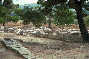
| Type of location: | Ancient name |
| Year | Population |
|---|---|
| 1991 | 3838 |

International arrivals to Greece via road are back on track marking a 12% increase in the first three months of the year to 1.2 million....
Mon, 29 Apr 2024
Read more...
A revised set of criteria for the star classification of hotels in Europe is scheduled to take effect in January 2025....
Fri, 26 Apr 2024
Read more...
A total of 107,204 people will be going on holiday this year subsidized by the Greek state with up to 400 euros as part of the "Tourism for All" program. ...
Fri, 26 Apr 2024
Read more...
Athens Airport's CEO adjusted initial revenue projections upward in light of positive Q1 data, forecasting arrivals to reach 30 million in 2024....
Fri, 26 Apr 2024
Read more...
Ferry and public transportation strikes have been announced for the May 1 Labor Day holiday in Greece....
Fri, 26 Apr 2024
Read more...
Greece's attractiveness as an ideal destination for high-quality investments in the hotel sector was on the agenda of a meeting between Tourism Minister Olga Kefalogianni and the Ambassador for Singapore Simon Tay....
Fri, 26 Apr 2024
Read more...
Receive our daily Newsletter with all the latest updates on the Greek Travel industry.
Subscribe now!