Listed 100 (total found 151) sub titles with search on: Sights for wider area of: "MAKEDONIA CENTRAL Region GREECE" .
ARNEA (Town) HALKIDIKI
It is situated 500m northerly from the square of Arnea and it is an amusement ground. In the middle of the wood there is the chapel of St. Paraskevi who is celebrated on 26th July. Visitors can come in Arnea on that month, enjoy the festivity of St. Paraskevi, attend to a series of cultural events, which take place during that time and also taste the traditional soup (Kourbani) which is offered for free.
The place is organised in such way that it is suitable for children to play. There are refreshment bars, restaurants and places of amusement for all the ages.


SERRES (Town) MAKEDONIA CENTRAL
St. Anargiri Valley, on the road that leads to the Acropolis, is a real "lung" for the city of Serres. It is a fascinating place. What makes this rural position so fascinating is the overgrowth, the greenery, the trees, plus the shadow from the leafy broad-leafed, old plane trees around the water that continually flows into the valley. The natural beauty of the site, has been developed even more after the construction of the artificial lake, swimming pool, indoor gymnasium, outdoor basketball and tennis courts and also countless other entertainment centers which have to offer "unforgettable" moments.
Situated only 2Km east of the city, the landscape is drowned in vegetation small waterfalls an streams.
SIDIROKASTRO (Town) SERRES
SYMVOLI (Village) SERRES
The Blue Water in Simvoli is fresh spring water appropriate for the breeding of trout
TORONI (Municipality) HALKIDIKI
In the centre of the area rises the mountain side Dragoudeli, the southern part
of mount Itamos, with its rich ecosystem, home to many rare species of flora and
fauna it is a veritable refuge for birds and wild animals.

ARNEA (Town) HALKIDIKI
It was built in 1872 next to the central church of St. Stefanos. It is the most well built school of the 19th century in Chalkidiki. The walls are built according to the technique that was followed in Agion Oros at that time. Nowadays, the building, which is restored, houses the Town Hall.
Tel: +30 23720 22744
Fax: +30 23720 22877
EDESSA (Town) PELLA
This tile-covered building -on a level with the ground from one side
and two-stories-high on the side of the Plains- has got openings that are symmetrically
formatted on the outside. Morphologically influenced by the neoclassical architectural
school (pseudo-pilasters, frames of openings, curved eaves, etc.), the edifice
is in fact a rectangular undivided structure that is interrupted only by two rows
of wooden pillars.
The year of construction (1877) is inscribed on the founding-plate,
above the main entrance slate, that reads: "The Greek Orthodox public of the town
of Edessa, helped by art-loving foreigners, raised this edifice of the Muses for
the enlightenment of the Edessaen daughters, in the month of April of the year
1877 of our Lord".
Today, the building belongs to the City of Edessa and, although it
officially serves as a Museum of Byzantine Art, is being used as a multi-cultural
center.
This text is cited May 2003 from the Hellenic Ministry of Culture URL below, which also contains image.
MONI EIKOSSIFONISSIS (Monastery) SERRES
In the middle of the main Monastery is situated the imposing temple
of the Presentation of the Blessed Virgin Mary in Temple and includes the Superior’s
quarters, the cells of the Nuns, the Archontariki (reception room), the Chapel
of St. Varvara with the holy water, the Museum, the Refectory, the workshops and
related installations, while the whole Monastery complex is enclosed in walls
(enceinte).
Before getting to the Monastery one comes to the monument erected
for the 172 monks slaughtered in 1507 by the Turks.
At the external part of the wall there is a place of worship built
with excellent quality marble and close to it another place of worship with a
dome, under which there is holy water. Next to it stands the Cemetery with the
small church of Saints Anarghiri.
To the southeast corner of the Temple stands the Monastery’s
bell-tower. Outside and over the walls to the east, stands an old wind mill, the
"Blessed Virgin Mary Sedile" and a small place of worship.
This text (extract) is cited September 2003 from the Prefecture
of Serres tourist pamphlet.
MONI TIMIOU PRODROMOU SERON (Monastery) SERRES
In the middle of the courtyard stands the main church (Katholikon)
built in 1854 and to its west stands the Phiale, a roofed open-air basin for holy
water, serving liturgical purposes at the feast of Epiphany and every first day
of the month. The main church is surrounded by the Nuns’ cells, the superior’s
cell, the buildings of the Priest School and the Refectory. To the southwest of
the courtyard and to the right of the main gate, stands the quadrangular Tower,
dating from the second "proprietor’s" time. In 1876 the Tower
was repaired and since then it has been transformed into a library. It was there
that there used to be conserved 100 volumes of manuscripts, 1500 printed documents,
4 chrysobulls, 5 patriarchal sigillia and other pieces that were looted and carried
of during the wars. Next to the Tower stand the ARCHONTARIKI (reception room),
dating back to 1795, with internal murals of landscapes, cities, ports and other
decorations.
This text (extract) is cited September 2003 from the Prefecture
of Serres tourist pamphlet.
SERRES (Town) MAKEDONIA CENTRAL
Bezesteni, a building from the 16th-17th century is in the central square of the city and operates as an Archeological Museum, where all the archeological wealth of the Prefecture has been housed.
BEZESTENI Bezesteni, was built according to the model of byzantine markets and probably by a Greek architect. Its name means "fabric market". Those indoor markets (Bezestenis), were very popular and typical of Muslim towns. Their example was followed by the conquered byzantine cities. A Turkish sightseer of the 17th century wrote in his book that "there is a wonderful stone-built building, covered in lead and this is Bezesteni". Today in Greece there are only two Bezestenis that are still preserved: one in Thessaloniki and the other one in Serres.
On Merarchias street a neo-classical building is the seat of the Prefecture of Serres. Built at the end of the 19th century by the architect Xenofon Paeonidis, it is a typical landmark of the city of Serres
THESSALONIKI (Town) MAKEDONIA CENTRAL
Το πιο χαρακτηριστικό κτίσμα του πρώτου αιώνα της τουρκοκρατίας, όπου
είναι φανερή η τεχνική των βυζαντινών είναι η Σκεπαστή Αγορά ("Μπεζεστένι"),
που βρίσκεται στη διασταύρωση των οδών Εγνατία και Βενιζέλου, σε ένα σημείο της
παλιάς πόλης της Θεσσαλονίκης, που φαίνεται πως ανέκαθεν αποτελούσε το κέντρο
του εμπορικού τομέα. Οι δύο άλλωστε δρόμοι (Εγνατία και Βενιζέλου) υπήρχαν στην
ίδια θέση από τα αρχαία χρόνια και ακόμα λίγο πιο πάνω (βορειοανατολικά) υπάρχει
η Αρχαία Αγορά της πόλης. Το Μπεζεστένι, για το οποίο μιλούν με θαυμασμό οι περιηγητές
του 16ου αιώνα, θεωρώντας το ως την ομορφότερη αγορά των Βαλκανίων, στέγαζε διάφορα
επαγγέλματα, κύρια όμως υφασματέμπορους και χρυσοχόους. Μάλιστα η αγορά λειτουργούσε
με οργανωμένο τρόπο και με συντεχνιακούς κανονισμούς.
Οι πληροφορίες περιλαμβάνονται στο βιβλίο του Απόστολου Παπαγιαννόπουλου
με τίτλο: ΜΝΗΜΕΙΑ ΤΗΣ ΘΕΣΣΑΛΟΝΙΚΗΣ.
Το κείμενο παρατίθεται τον Αύγουστο 2003 από την ακόλουθη ιστοσελίδα, με φωτογραφία, του Πανεπιστημίου Μακεδονίας
The main market (Misir-tsarsi or Egyptian market) was concentrated
outside the walls as far as the port; its more than 500 stalls and shops carried
sugar, rice, coffee, linen and a host of other exotic products.
There too were to be found the tanneries ('tabakika') and the Halitzatzilar
(the famous rug market); markets for other products -- such as the Chalkeon (the
coppersmiths' district, which went back to Byzantine times) -- were found throughout
the town. The market on the quay, known later as Istira, was dominated by the
presence of Jewish merchants and a few Europeans.
By kind permission of:Ekdotike Athenon
This text is cited Nov 2003 from the Macedonian Heritage URL below, which contains image.
The buildings of those days are somewhat grandiose, often combining
neoclassical features and baroque ornamentation with an Ottoman touch.
Representative examples of the architecture of the period are the
Customs House, which shows a strong French influence, the Ottoman Bank (now the
State Conservatory) and the Army Barracks. Finally, the Government House with
its austere dignity expresses the attitudes as well as the vigour of a threatened
authority.
The interweaving of Byzantium, the Renaissance, Islam and Classicism,
so characteristic of Thessaloniki, reaches its peak in the majestic yet charming
Yeni Cami (mosque).
Hamidye Boulevard
Hamidye Boulevard (now Ethnikis Amynis) ended at the Fountain, a gift
of the Sultan Abdul Hamid II, who had envisaged this long avenue. City residents
long remembered the cherry flavored sirop that bubbled from the fountain at the
street's inauguration.
The boulevard, also known as the Rue Royale (since almost all the
buildings lining it belonged to the Sultan), housed the foreign consulates, luxurious
mansions and smart cafes, as well as the renowned Idadie School (now part of Thessaloniki's
university).
The Turks called the whole new waterfront area Hamidye, though the
Greeks nicknamed it Pirgoi (mansions) or the district of Exohes (the countryside,
as it was situated outside the city's walls).
By kind permission of:Ekdotike Athenon
This text is cited Nov 2003 from the Macedonian Heritage URL below, which contains images.
Thanks to donations from Athenian societies and benefactors, the Greek
community erected a series of buildings at the turn of the century. Most of them
were schools and philanthropic institutions (the Papafeio Orphanage, the Hariseio
Hospital, the Hariseio Old People's Home, the Konstantinidis School, etc.).
In addition the Greek community built the big complex at the cathedral
of Ayios Grigorios Palamas, which included the metropolitan's residence, the high
school, the teachers' college and the Greek consulate.
Thus the Greek community had begun to make its presence felt with
more self-confidence; the spare neoclassicism that distinguishes most of these
buildings copied the style adopted in free Athens.
By kind permission of:Ekdotike Athenon
This text is cited Nov 2003 from the Macedonian Heritage URL below, which contains images.
The first neighbourhood to be planned outside the walls, thus representing
the new European Thessaloniki, was that of Pirgoi (mansions). Greek and foreign
architects, educated in Europe and Constantinople,
built luxurious villas here for wealthy Jews, Greeks, Turks, Donmeh and Franco-Levantines
(Europeans who had long made their home in the Ottoman Empire).
The waterfront villas even had small private jetties from which to
bathe in summer. Artisans connected with the building trades came to Thessaloniki
on a seasonal basis, as had the old guilds. Among them the master builder G. Siagas
and his sons stand out; they constructed the Casa Bianca and the Red Mansion for
the Georgiadis family from Siatista.
The Allatini were the most distinguished family not only of the Jewish
community but of the whole city.
Paul Lindau, who visited their mansion in 1888, remembered that "the
forecourt, where the members of the Allatini family had gathered to welcome their
guests, was lit up by many portable lampstands, each with six lamps, arrayed at
every point of the courtyard. As we entered, a host of servants received us...
Albanians wearing their characteristic fustanellas (pleated kilts)... The younger
members of the family, who had exchanged the beautiful costumes of their ancestors
for dull Western clothes, led us from the wide staircase, carpeted with impressive,
beautiful, thick rugs, to the wonderfully illuminated ceremonial hall on the first
floor..."
Lindau was also impressed by the mansion's guest rooms, which lay
off the courtyard, and extolled the view over the Thermaic
Gulf, the view at which, twenty years later, Abdul Hamid would gaze in frustration
for hours on end, exiled and imprisoned in the Allatini villa after his failed
coup.
By kind permission of:Ekdotike Athenon
This text is cited Nov 2003 from the Macedonian Heritage URL below, which contains images.
Tel: +30 2310 295170-1, 295149
Fax: +30 2310 295276
Tel: +30 2310 272910
Longitudinal church
of the cross-in-square type, with a square naos, a narthex on the west side and
a triconch sanctuary on the east. Four columns and four arches form a cross inscribed
in the square area of the naos. The centre of the cross is covered by an eight-sided
dome and smaller domes cover the two ends of the narthex. Two successive layers
of wall paintings are distinguished in the church, dated to the 11th and the 14th
century A.D., respectively.
The church was built in 1028 by the protospatharios (Byzantine official)
Christophoros, as is attested by the inscription on the marble lintel of the main
west entrance. After the conquest of Thessalonike by the Turks, in 1430, it was
converted into a mosque and again became a Christian church, with the liberation
of the city, in 1912.
In 1987, in the course of a study on the structural stability of
the building, several excavation trenches were opened in the courtyard of the
church.
After the liberation of the city, the wall paintings of the church
were cleaned from the turkish plaster that covered them. The building was damaged
by the earthquake in 1932 and was subsequently restored; the narthex and the south
pediment were then reconstructed. Similar work was also undertaken after the earthquake
of 1978.
The monument is now used as a church.
Tel: +30 2310 270008, 260915, 268480
Fax: +30 2310 268480
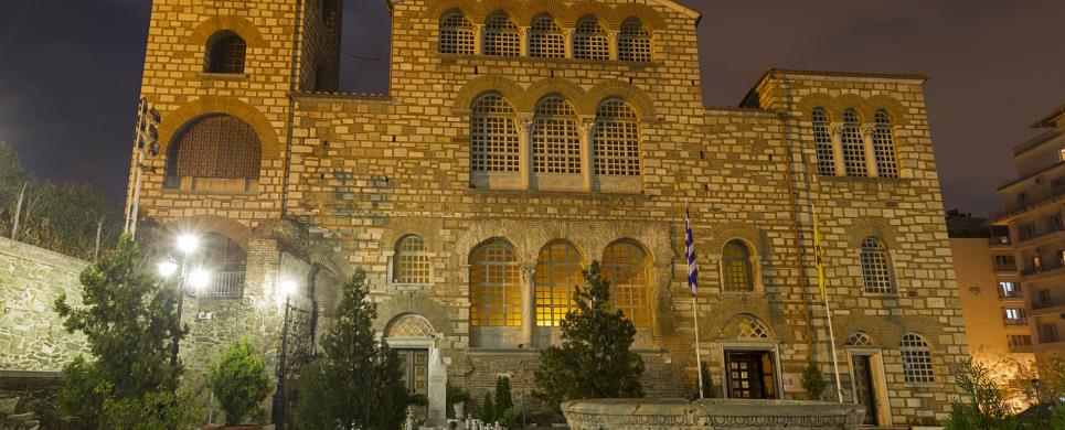
The
monument is a five-aisled basilica, with a narthex and a transept. Under the
sanctuary and the transept there is the crypt. A chapel of Saint Euthymios is
attached to the south-east corner of the church. Very few fragments of the sculptural
and pictorial (mosaics, wall paintings) decoration of the church, survived the
disastrous fire of 1917 but they are representative of the successive phases of
the monument's history.
The first church was a small oratory, built shortly after 313 A.D.
on the ruins of a Roman bath. In the 5th century A.D., the eparch Leontios founded
on the same site a large, three-aisled basilica which was burnt down in 626-634.
Shortly thereafter, the five-aisled basilica was erected. It was converted into
a mosque in 1493, it was restored to Christian worship in 1912 but it was again
destroyed in the great fire of 1917. It was rebuilt and started to function again
in 1949.
During the restoration of the monument after the fire of 1917, several
trenches were opened in the naos and the crypt. Systematic excavations were carried
out in 1946-49.
Restoration of the church was undertaken immediately after the catastrophe
of 1917. Work was stopped in 1938 and was again resumed in 1946. The monument
was rebuilt and started to function again in 1949. Today the monument is used
as a church.
In the crypt of Aghios Demetrios, an exhibition is on display to
the public. It includes the items that survived the fire of 1917 and those that
were brought to light by the recent excavations in the monument.
Tel: +30 2310 204150
The church is a rectangular building with a narthex, a domed, cross-in-square
naos and a tripartite sanctuary with a five-sided conch. A smaller dome covers
the central part of the narthex. Two chapels are attached at the east ends of
the north and south sides. The chapels originally flanked the ends of the U-shaped
ambulatory that once surrounded the naos.
The church was the catholicon (main church) of the Monastery of Theotocos
Perivleptos, built at the end of the 13th or the beginning of the 14th century,
by James, the metropolitan bishop of Thessalonike. During the Turkish occupation
it was converted into a mosque, probably between the years 1568-1571. Nearly all
the frescoes that adorned the interior of the church were then hammered down and
its walls whitewashed. After the liberation of the city in 1912, the monument
was restored to Christian worship.
Excavations in the front courtyard of the church were conducted by
the 9th E.B.A. in 1973. After the earthquake of 1978, several trenches were opened
inside the building and in the surrounding area.
The restoration of the monument is still in progress.
When the monument is completely restored, it will be turned over to
Christian worship.
Tel: +30 2310 221506
The original church was small and square in plan, with an apse
at the east end and an entrance in the west wall. In each of the four corners
of the building, a small chamber was constructed, thus forming a cross with equal
arms in the area of the naos. The whole west side of the church is now ruined
and the entrance is located on the south side. Of the interior decoration is preserved
the famous mosaic in the conch of the sanctuary, dated to the 5th-6th century
and fragments of wall paintings, dated to the 12th century A.D.
The church was built at the end of the 5th or the beginning of the
6th century, over an earlier, Roman building. It was the catholicon (main church)
of the Latomos Monastery but in 1430, after the conquest of Thessalonike by the
Turks, it was converted into a mosque and the mosaic and fresco decoration was
plastered over. The famous mosaic was discovered when the monument was turned
over to the Christian cult with the liberation of the city, in 1921.
In 1929, excavations were conducted on the interior of the church.
The monument has undergone several phases of restoration and consolidation
over the years. Recently, in 1980 the west wall was restored and in 1991 the propylon
on the south side was reconstructed.
The monument is used as a church.
Tel: +30 2310 202978
The nucleus of the rectangular church is a long timber-roofed
chamber with a U-shaped ambulatory along the three sides and a triconch sanctuary
at the east. The marble iconostasis is preserved almost intact as well as a considerable
amount of the painted decoration, which has been dated to 1310-1320 and is of
a very high aristic quality.
The
church was the catholicon (main church) of a monastery, dated to the early
14th century A.D. The name is related either to the philanthropic works of St.
Nicholas for the sake of the orphans, or to the probable founder of the monastery,
a member of the Byzantine Orphanos family. According to another suggestion, the
church was founded by the Serbian kral, Milutin. It is actually a metochion (dependence)
of the Vlatades Monastery and it functioned as a church even during the Turkish
occupation.
Excavations on the interior of the church were conducted in 1959-60
and again, in 1971, at the propylon.
The monument was restored in 1959-60. The monument is used as a church.
Tel: +30 2310 537915
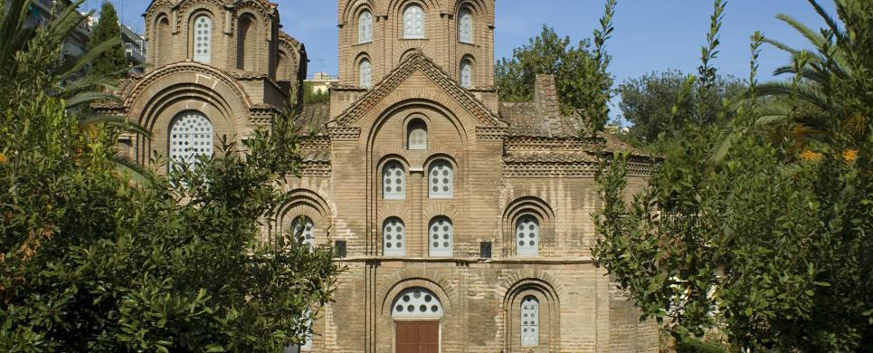
The church is of the complex cross-in square type, with a triconch sanctuary in the east, a U-shaped ambulatory surrounding the three other sides of the naos and an exonarthex to the west of the ambulatory. The decoration of the interior is a combination of mosaics (on the upper part of the walls) and wall paintings (on the lower part).
The church was the catholicon (main church) of a monastery, probably
dedicated to the Virgin. It was founded in 1310-14, by Patriarch Niphon I, as is attested by an inscription on the marble lintel over the entrance and the three monograms on the dosserets of three capitals on the west facade of the church. During the Turkish occupation of the city, in the years 1520-1530 it was converted into a mosque. At this time the golden tesserae of the mosaics were hammered down and the rest of the paintings whitewashed. After the liberation of the city in 1912, it was restored to Christian worship.
Excavations in the area around the monument began in 1995 and are
still in progress.
The monument was restored in 1940-41 and again after the earthquakes
of 1978. At the same time, the wall paintings were cleaned and restored.
Today the monument functions as a church.
Tel: +30 2310 227369
Three-aisled basilica with a narthex on the west side and a
second entrance with a monumental propylon in the middle of the south wall. To
the east of the propylon a building is attached, probably a baptistery or a diaconicon.
A small parecclesion (chapel) is formed at the east end of the north aisle. Of
the interior decoration a few fragments of mosaics have survived in the soffits
of the arches of the colonnades, dated to the 5th century A.D. Several parts of
the wall paintings dated to the 13th century, are also preserved in the south
aisle.
The
church was built in the middle of the 5th century, on the remains of a Roman
bath. It was dedicated to the Holy Virgin "not made by human hands" (Acheiropoietos)-the
name most probably refering to the cult image - and it was the first church in
Thessalonike to be converted into a mosque after the conquest of the city by the
Turks, in 1430. During the turkish occupation, pracically all the figurative decoration
of the church in mosaics and frescoes was hammered down. In 1930, it was turned
over to the Christian cult.
Excavations were carried out in 1927-28, in 1946-47 in the precinct
of the church and in 1961, in the area to the west of the church. Following the
earthquake of 1978, in the course of the study for the restoration of the building,
several trenches were opened on the interior and in the courtyard.
Extensive restoration work was undertaken at the beginning of the
century, in 1927-28 and again, in 1949. After the earthquake of 1978, restoration
of the monument began once again and the work is still in progress.
The monument is used as a church.
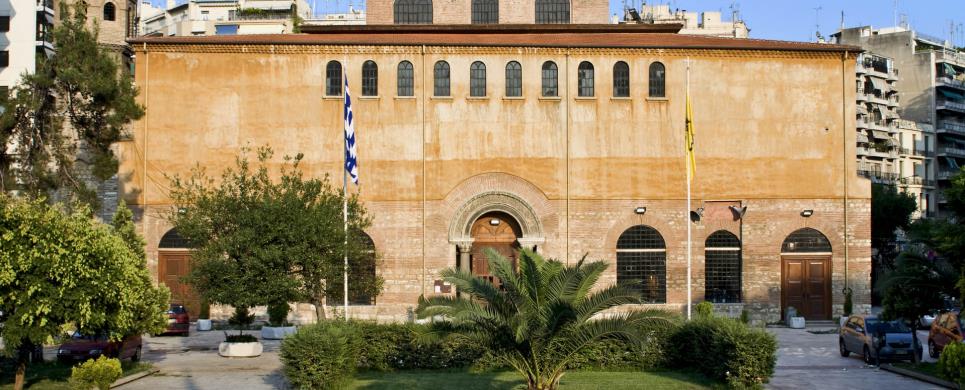
Tel: +30 2310 270253
It is a rectangular church, with a cross-in-square nucleus,
which is covered with a dome. It is surrounded by a U-shaped ambulatory on the
three sides, while the east is occupied by the tripartite sanctuary. The present
architectural form of the monument is in many aspects, quite different from the
original 7th century structure. Several parts of the interior pictorial decoration
are preserved: mosaics on the dome and the sanctuary, dated to the 8th-12th centuries
A.D. and wall paintings of the 11th century, in the narthex.
The
church was built in the 7th century, on the ruins of a large, five-aisled
basilica dated to the 5th century A.D. It was the metropolitan church of Thessalonike,
dedicated to the Wisdom (Sophia) of God and soon became the nucleus of a large
building complex, with administrative and religious functions. In 1524, it was
converted into a mosque, it was burnt down in 1890 and was repaired between 1907
and 1909. After the liberation of the city, in 1912, it was restored to Christian
worship.
Excavations were conducted in the years 1936-40, 1946, 1948 and 1961
and, after 1978, during the restoration of the building which was damaged by the
earthquake.
The building was restored in 1907-1909, 1941 and again, after the
earthquake of 1978. In 1961, the wall paintings of the narthex were uncovered
and cleaned, after the turkish plaster was removed.
The monument is now used as a church.
OURANOUPOLIS (Ancient city) AGION OROS
Pages of Macedonia University
PALIO GYNEKOKASTRO (Settlement) KILKIS

PLATAMONAS (Small town) PIERIA
Tel: +30 23520 42775, 44470

SERRES (Town) MAKEDONIA CENTRAL
Tel: +30 23210 56205
Fax: +30 23210 56205
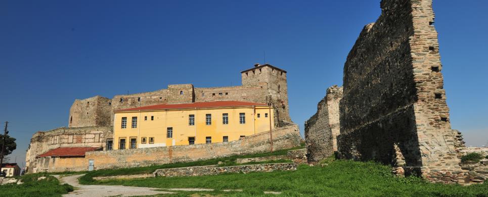
The ancient and Byzantine acropolis
lies on a hill called Koulas, north of the city of Serres. Several parts of the
fortification are preserved and the outline of the wall can be restored. The SE
and the NW tower (the so-called "Orestes' tower") are preserved in very good condition.
The enclosure wall of the acropolis dates to the 13th-14th centuries.
The architectural phases of the whole structure have not been distinguished
since the acropolis has not been excavated, with the exception of the foundations
of the "Orestes' tower".
Restoration work has been carried out at the wall masonry of the SE
tower and the outer "mantle" of the fortification wall, with parallel repairing
of the joints wherever necessary. Moreover, small walls were constructed to support
sections of the southern wall.
The most important monuments of the site are:
Ruins of the acropolis of Serres. They are of the utmost importance since
they are the only preserved parts of the fortification of Serres and include one
of the most remarkable defensive constructions to be seen in Northern Greece,
the "Orestes' tower". The acropolis is oval in plan, with the long axis in E-W
direction. The gates are not preserved, but they must have existed on the east
and west sides, next to the preserved towers. The northern side of the acropolis
was particularly strengthened with bastions (three of them preserved today) due
to the morphology of the terrain.
"Orestes'
tower".
It is the NW tower of the acropolis and the most outstanding construction of the
ancient city's fortification. Its importance lies both in its overall form and
in the clay inscriptions built in its west wall. According to these, the tower
was built in 1370 by Orestes, the castle-guard of Serres, after an order of Stephen
Dusan.
Church of St
Nicholas. It is located at the NE end of the castle, very close to the
fortification wall. It is a triconch, single-aisled domed church with a subterranean
crypt and dates to the first half of the 14th century.
The powerful Acropolis, in the towers of which still lives the Byzantine
spirit, stands epically on the imposing pine-hill which dominates the modern city
of Serres. The Byzantine Acropolis was built on the site of an ancient fort which
defended the city in the 7th and 6th centuries BC. In the Byzantine period, it
is referred to in many golden bulls (imperial decrees) of various Byzantine emperors
as the "Castle". With time, the word castle ended to mean the whole
city. Until the beginning of our century, the inhabitants of Serres were known
by the neighbouring villages as the "Kastrinoi" (inhabitants of the
castle). After the Franks conquest, the Acropolis was known as the "Castelli"
a name that it preserved until the Tourkokratia (Turkish Dominion). The Turks
gave it the name of "Bas Koule" (= top tower), probably after the large
tower of the west wing. Its current name "Koulas" (tower) originates
from the Turkish one. In Byzantine times, the Acropolis was enclosed by a spindle
shape strong wall, extending from West to East. It encloses various Byzantine
buildings, i.e. the houses of the administrators and other officers of the State.
The Acropolis also housed the appointed by the Byzantine authorities, commander
known as the "guardian of the castle". Leon Ajanetes was a well-known
guardian of the castle and he endorses golden bulls of the first half of the 14th
century. According to the traveller Evliya Celebi, the Acropolis wall had two
gates, one to its east and one to its west end, very close to the respective towers.
Traces of the second gate can still be seen today near the large tower of the
west side. Tall and strong towers reinforced the defence of the wall, out of which
only the strong and stately tower of the west side "The Tower of the King" still
stands only destroyed at the top. This huge tower of presumably almost 20 meters
had a double mission: it protected the city on one part and on the other part,
it constituted the last defence post in the case where the enemy captured the
remaining parts of the Acropolis. An interesting inscription on the right end
of the "Tower of the King" reads, to the prevailing opinions: "ΠΥΡΓΟΣ
ΑΝΔΡΟΝΙΚΟΥ ΒΑΣΙΛΕΩΣ ΟΝ ΕΚΤΙΣΕΝ ΟΡΕΣΤΗΣ" (= The Tower of Andronikos built
by Orestes). The foundation of the Byzantine Acropolis dates from the 9th century
AD. It is then that for the first time, historical sources mention that Emperor
Nicephoros Phocas reinforced the city of Serres. The irresistible Acropolis escaped
the catastrophe. Nevertheless, the definitive capture of Serres by the Turks,
in 1383 AD brings along the desertion and progressive demolition of the Acropolis
as the Turks were systematically destroying the castles, so that they do not become
breeding grounds of the resistance, in the event of a revolutionary movement of
the unredeemed Greeks.
This text (extract) is cited September 2003 from the Prefecture
of Serres tourist pamphlet.
SIDIROKASTRO (Town) SERRES
The defensive enceinte of Byzantine Sidirokastro with an inner and
an outer wall, two gates and a central circular tower with a cistern, are preserved
on the hill of Isare. They date back to the times of Andronicus III Paleologus
(1328-1341). The more recent church of Saint Demetrios is built on the hillside.
Its iconostasis is the facade of a tomb of the Hellenistic Times chiseled in the
rock.
This text (extract) is cited September 2003 from the Prefecture
of Serres tourist pamphlet.
THESSALONIKI (Town) MAKEDONIA CENTRAL
Tel: +30 2310 968860
Fax: +30 2310 968869
The lie of the Byzantine walls of Thessalonike coincides with that of the Roman ones. Built of wide courses of undressed stones and narrow ones of brick over a length of five miles, they were almost square in plan and 30-36 feet in height, while to the north they were joined to the walls of the Acropolis.
Fortified at intervals with towers and gates, the wall was a double one, at least in the more level sections, the inner and outer wall having a distance of ten metres between them. There were no gates in the sea walls, while the artificial harbour built by Constantine the Great within the walls had a low wall around it facing the city and a breakwater, the Tzeremboulon, on its seaward side.
Extensive rebuilding of the walls was carried out in Early Christian times (late 4th-early 5th centuries) by Ormisdas, while frequent barbarian raids in the 5th and 6th centuries necessitated frequent reinforcement of the walls. The ease with which the Saracens captured the city in 904 through the defenders' negligence led to the walls being strengthened to resist the danger presented by the Bulgarians.
Major repair work was undertaken in the 13th and 14th centuries by the Palaeologan dynasty both to the walls (e.g. the Anna Palaeologina Gate) and to the Eptapyrgion (Acropolis). Venetian indifference facilitated the capture of Thessalonike by the Turks, who then paid great attention to the city's fortifications.
The text is cited from the webpage: www.macedonian-heritage.gr/HellenicMacedonia/en/C2.3.D.html
THESSALONIKI (Ancient city) MAKEDONIA CENTRAL
Tel: +30 2310 968860
Fax: +30 2310 968869
The lie of the Byzantine walls of Thessalonike coincides with that of the Roman ones. Built of wide courses of undressed stones and narrow ones of brick over a length of five miles, they were almost square in plan and 30-36 feet in height, while to the north they were joined to the walls of the Acropolis.
Fortified at intervals with towers and gates, the wall was a double one, at least in the more level sections, the inner and outer wall having a distance of ten metres between them. There were no gates in the sea walls, while the artificial harbour built by Constantine the Great within the walls had a low wall around it facing the city and a breakwater, the Tzeremboulon, on its seaward side.
Extensive rebuilding of the walls was carried out in Early Christian times (late 4th-early 5th centuries) by Ormisdas, while frequent barbarian raids in the 5th and 6th centuries necessitated frequent reinforcement of the walls. The ease with which the Saracens captured the city in 904 through the defenders' negligence led to the walls being strengthened to resist the danger presented by the Bulgarians.
Major repair work was undertaken in the 13th and 14th centuries by the Palaeologan dynasty both to the walls (e.g. the Anna Palaeologina Gate) and to the Eptapyrgion (Acropolis). Venetian indifference facilitated the capture of Thessalonike by the Turks, who then paid great attention to the city's fortifications.
The text is cited from the webpage: www.macedonian-heritage.gr/HellenicMacedonia/en/C2.3.D.html
ZOGRAFOU (Village) HALKIDIKI
7 km before Nea Moudania, lies Zografou village which is inhabited
by refugees. The village was built around the establishments of "metochi" (property
belonging to a religious institution) of Zografou Monastery at Agion Oros, and
was named after it. Today, what has been saved from "metochi" is the Byzantine
fortress which is a construction of the 14th century, as well as the church, founded
in 1842, and other subsidiary buildings from the 19th century. The monumental
fountain of "metochi", built in 1853, is of great interest and lies only 50 km
on the western side of the fortress.

ALISTRATI (Small town) SERRES
Tel: +30 23240 82045
Fax: +30 23240 82046
The cave of Alistrati is considered to be as one of the finest and largest in Greece, and possibly in Europe, where nature show its greatest power of creation.
At the entrance of the cave is the hall, a very nice room of 8 m height. From there start several galleries with great height and rich decoration of stalactites and stalagmites. The cave has also many levels that are unexplored yet.
DAFNI (Village) SERRES
Intersting small cave, known as the Cave of St. Marina can be found in the Village of Dafni. The inhabitants believe that during the difficult years of the Turkish domination the village population was greatly relieved at this cave while they were secretly praying, as we can see on the worn wall-paintings in the caves. According to rumours given by the elders ofthe village, the cave's wall-paintings, which are being repaired, were destroyed by the Turks in 1922 while they were leaving.
EPTAMILI (Village) SERRES
It is one of the largest in Greece and it was discovered in 1965 during the excavation of the local quarries. The cave's opening is in a hill which consists of limestone and has to do with an underground river whose natural entrance has been covered with slime and boulders. On the storeys of the sewers of the cave there are decorations from stalactites and stalagmites in fine patterns, which after the opening of the entrance to the caves and with the help of the circulation of air, dried out and created a novel and pure white decoration which is found in a Greek cave for the first time. Generally, the chambers, sewers and passages are fully decorated. You can see things such as unique flower-shaped recrystalization, complexes of wonderful stalagmites, huge stalactites and so on.
The Cave of Eptamili, even if it is closed for the time being, it is considered to be a place of general touristic interest because firstly of its size and secondly because of its rare kind in the flat Prefecture of Serres.
KILKIS (Town) MAKEDONIA CENTRAL
Tel: +30 23410 20054
LOUTRA ARIDEAS (Settlement) PELLA
Regions of exceptional natural beauty are found here, as well as a
cluster of 15 caves and cave shelters, the existence of which became known at
the beginning of the 90s after researches of a group of speleologists and led
to the creation of the first Speleological Park of the country.
The cluster of caves is just 100 meters away form the village of Loutra
Loutrakiou and the rock-paintings that have been found in it, in combination with
the objects found in the interior and the surrounding area (stone tools, knifes,
arrows etc), lead to the assumption that the area was first inhabited at the end
of the Neolithic Age and at the beginning of the Copper Age (cave men).
It is impressive that among the speleological findings, we find fossils
of animals that existed many thousands or even millions of years ago.
Scientists consider the discovery of fossils of the cave bear (Ursus
Spelaeus) as important, the presence of which is placed in the Upper Pleistocene
period (120,000-10,000 years), whereas the paleontological interest is strengthened
by the discovery in the wider area of the invertebrate Hippurites (Vaccinites)
Atheniensis (presence in the Upper Cretidic period -75 million years), as well
as the corals of the Cycloseris genus that appeared some 70 million years ago.
During the last years, mild interventions have been realized, which
aim at the improvement of access to the site of the speleological park and allow
its exploitation for tourist, scientific and educational purposes.
This text (extract) is cited October 2003 from the Pella
Prefecture Tourism Committee tourist pamphlet.
VRASNA (Small town) THESSALONIKI
This cave is found in the "Makedonika Tempi" Valley.
CHRYSSOPIGI (Settlement) SERRES
Chrisopigi is a wonderful resort of Serres with cool springs, marvelous climate and excellent freshness. That's why the settlement which is "hibernated" during the winter months, becomes a life of activity during the summer months with people from Serres moving to their county houses. The scout and school camps offer great hospitality to their little holiday-makers. In Chrisopigi there is a Forestal and Forestal seedbed Research Centre for the produce of coniferous trees in order to be used for artificial reforestation. There is also a remarkable animal breeding farm , where you can see roes, quails, pheasants, while the forestry area has been put in shape in such a way, so that if offers an ideal environment for those who visit Chrisopigi just for a pic-nic.
KASTANOCHORI (Village) SERRES
The Forest of Kastanohorion is a unique chestnut forest with a wonderful decor of very old chestnut trees.

PALEO KERAMIDI (Village) PIERIA
Photo Album in URL, information in Greek only.
AFYTOS (Village) HALKIDIKI
During the second half of the 19th cent. There appears to have been
considerable building activity. The village houses are architecturally very interesting,
being made of local porous stone. Among the oldest standing are those of Katsanis
(approximately 1860), Papavasiliou (1864), Galanis (1876), Aletras (appprox 1889)
and K. Athanasiades (1898). In addition to the above, all the old stone hosues
fo Athytos with their builders’ inscriptions and stone relief exhibit the
skill and artistry of the workmen of the past.
(text: Gerakina N. Mylona)
This text (extract) is cited November 2003 from the Community
of Athytos tourist pamphlet (1994).
ARNEA (Town) HALKIDIKI
It is a large mansion with two floors, which was built in the beginning of the 19th century or maybe the second half of the 18 . It is the only one of its kind in the whole* Chalkidiki. Its ground plan has the shape of n, on the ground floor there are few open places and on the upper floor everything that is made of wood is very elaborate and artistic. It may probably be a piece of work of people who came from Epirus. Nowadays, it houses the Historical and Folklore Museum of Arnea
SERRES (Town) MAKEDONIA CENTRAL
A house that gives us a clear picture of folk architecture is Zaparas' house, which reminds us of the well-known type of Macedonian architecture. In this type of architecture the ground plan of the house is in a "Π" shape. The exterior formation of the building is characterized by gravity and abstinence, while this was always the case with all the mansions during the Turkish domination. The particular attention as far as the spans, doors and ceilings are concerned shows the great wealth of the owner. This mansion is a cross-section of the development which is noticeable in Macedonian architecture in the middle of the 19th century and continues until the beginning of the 20th century.
KERKINI (Lake) SERRES
In the flat and semi-mountainous area, important hydro-biospheres
are developing which are of great international significance and acceptance. The
most essential hydro-biosphere is the one in Kerkini lake. It is a miracle of
nature which came about by man's technical intervention on the natural characteristics
of Strymon river. The water extent, which varies from time to time from 54.250
sq. km to 72.100 sq. km ., works out to be useful in two ways: as a technical
work of great agricultural utility and as a hydrobioshpere for thousands of water
fowls. This wonderful biosphere is recouped by the International Convention of
Ramsar and presents numerous admirable elements. Thousands of birds, both rare
and protege, riverside forests, water-lilies in a large area, fish variety and
fantastic panoramic view from the mountains of Beles and Krousia give it a characteristic
tone.
The main water provider of the lake is Strymon river. Additionally,
there is Kerkinitis river from Krousia that flows into the lake. The lake was
created where Kerkini lake was by making embankments on the Eastern and western
sides and a dam was constructed near the village of Lithotopos, which started
functioning in 1932. After the construction of the dam, the form of the initial
hydrosphere changed completely. The human intervention usually retracts or takes
negative action against the natural processes. Kerkini lake is a rare example,
where the gentle human handling had the exact opposite result. As time went by,
the lake's capacity was reduced because of the substances that were washed up
by Strymon river. So the rising of the embankments and the construction of a new
dam was necessary, which was started in 1982.
PETHELINOS (Village) SERRES
THESSALONIKI (Town) MAKEDONIA CENTRAL

Receive our daily Newsletter with all the latest updates on the Greek Travel industry.
Subscribe now!
