Listed 43 sub titles with search on: Sights for wider area of: "ACHAIA Prefecture GREECE" .
PATRA (Town) ACHAIA
This pine-clad hill is called the "veranda" of the Patraic Gulf, due
to the excellent view that it offers.
Dassylion (small wood) lends itself for promenades and jogging. It
is pleasantly walked, thanks to the special configuration of the paths running
along the wood and the cool shadow offered by the very high trees.
There is a Municipal Tourist Kiosk harmonised with the surroundings
from where one can admire Patras, the port, the north coasts of Messologhi up
to the Roumeli's Mountains. In the afternoon traffic increases as many are those
that go uphill to Dassylion to get a view of Patraic Gulf that turns purple red
from the unique colours of the sunset.
Pines were planted in Dassylion in 1916 by the students of Primary
Schools, two Gymnasiums and the Business School under the supervision of the Austrian
forester Stegel. Andreas Michalopoulos is the one that had the idea of planting
the barren hill.
This text is cited Apr 2003 from the Municipality of Patra URL below, which contains image.

PATRA (Town) ACHAIA
On a green-clad hill, eight km SE of Patras' centre, are located the
facilities of ACHAIA CLAUSS winery, distinguished as one of the topmost tourist
sites of the region.
Its founder, Bavarian Gustav Clauss arrived in Patras in 1854 to work
in a German company dealing with exportation of raisin. During an excursion, he
visited this region that charmed him with its natural beauty. He bought a small
vineyard just to produce some wine for self-consumption and he ended up to the
establishment of this Castle-Winery that survives intact till now. In 1861 he
founded ACHAIA CLAUSS Co and the excellent quality wines, including Mavrodaphne
of Patras, conquered both Greek and international market.
The stone-made buildings, the large oaken carved barrels with one
century-old Mavrodaphne, the traditional cellar where visitors are welcomed as
well as the unique landscape with the breath-taking view attract approximately
200.000 visitors per year.
Open daily for visits from 09.00 to 17.00
Tel: 2610325051-9
This text is cited Apr 2003 from the Municipality of Patra URL below, which contains image.
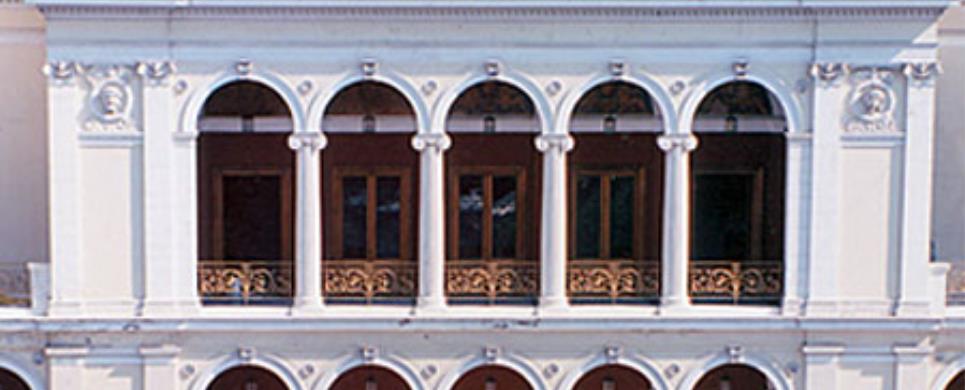
The building of the
municipal theatre "Apollon" was erected in 1872 after plans by the German
architect Ernst Ziller. The building is characteristic of the 19th century neoclassical
style. It was built as a theatre and it is located in the central square of the
city of Patras.
Conservation work on the theatre has been carried out at intervals.
"Apollo" Municipal Theatre is located on King George I Square and
is considered as the most impressive architectural ornament of Patras, while it
is one of the first opera theatres in Europe. It was built on 1872 according to
the designs of the German architect Ernst Ziller, with the financial contribution
of Patras' merchants.
It has three rows of boxes and seats dressed with red velvet, gallery
and pit. Since its first year of operation, Patras' people had the opportunity
to enjoy opera performances of great composers such as Verdi, Apolloni, Puccini,
Ricci, Donizetti, Bizet, as well as performances of operettas. Later on, the theatre's
stage hosted major Greek theatrical troupes, such as that of Kotopouli, Myrat,
Kyveli, Plessas, while during Carnival it has been the venue of dancing parties
and masked balls. So, in the 50's it was identified to the organization of famous
and unique in Greece "Bourboulia".
The Municipal Theatre is since 1988 the permanent venue of the Municipal
and Regional Theatre of Patras, which stops performing only during Carnival, when
tradition imposes the beginning of balls and, of course, the "Bourboulia".
Telephone: 2610273613
This text is cited Apr 2003 from the Municipality of Patra URL below, which contains image.
PATRA (Town) ACHAIA
Tel: +30 2610 623390
Fax: +30 2610 623005
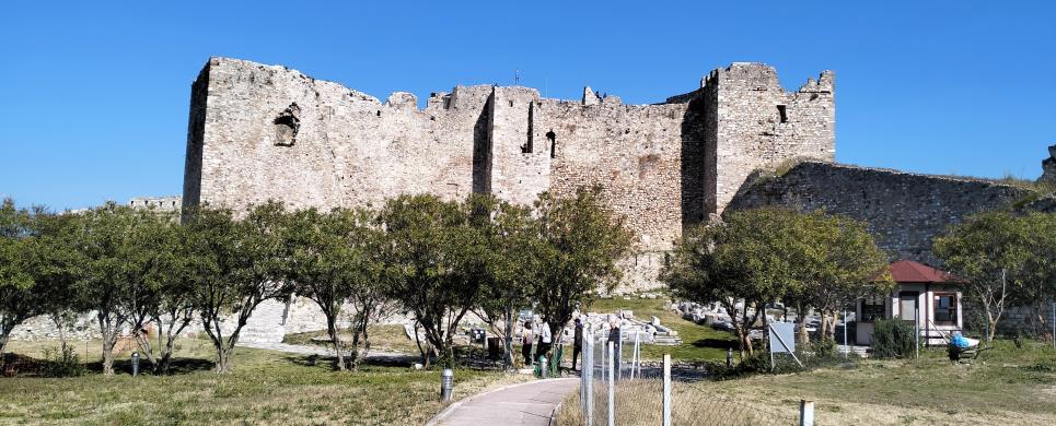
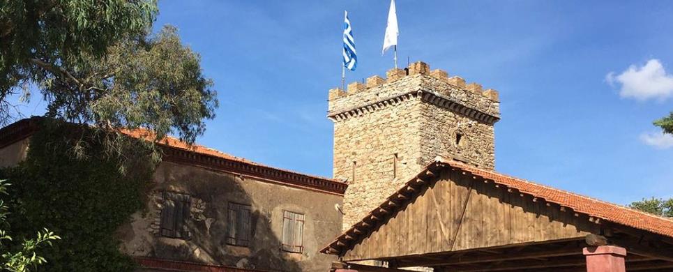
Built in the second half of the 6th century AD, the Castle of Patras rises on the northern foothills of Mount Panachaikon, on the site of the city's ancient Acropolis. lt consists of a long and wide outer enclosure with towers and bastions, surrounded by a moat on three sides, which covers an area of approximately 22,600 square meters. The entrance is in the middle of its east side. The inner enclosure with its six towers, known as the Ήexapyrgion', stands on a natural mound in the Castle's northeast section.
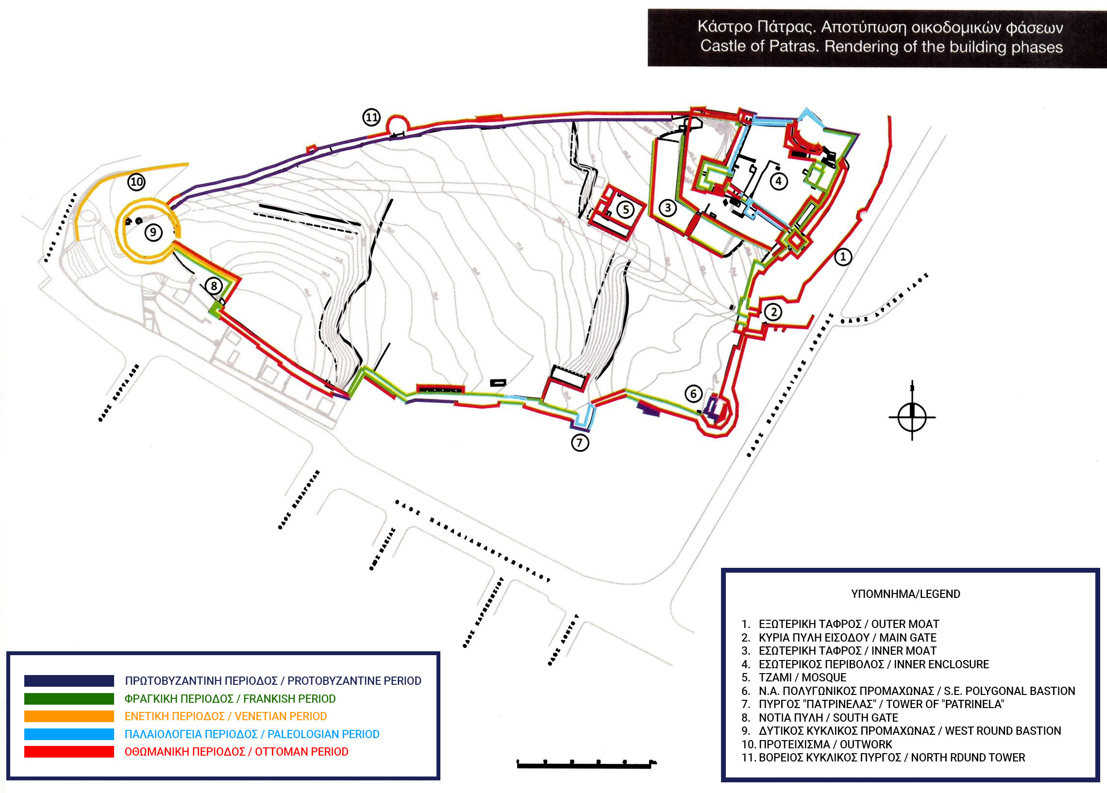
The Castle's continuous use for the region's defence and as an administrative and military centre from its foundation to modern times had as a consequence the continual repairs and additions, a testimony to all of the peoples that have passed through it. ln 805, the Castle was besieged by the Slavs and Saracens, whose defeat was attributed to a miracle by Saint Andrew, the city's patron saint. ln 1205, Frankish knights occupied Patras and constructed the Castle's inner enclosure. ln 1408, the Pope leased Patras to the Venetians, whose main addition to the Castle is the circular bastion at the northwest end. Konstantinos Palaiologos, Despot of Mystra, occupied the Castle in 1430 and added two towers, one on the south side and another at the north end of the inner enclosure, on the west side of which eight semi-circular arches were built. ln 1458, the Castle surrendered to the Ottomans, whose interventions are evident in almost all of the Castle's parts. The North Wall was reinforced by a circular tower, and polygonal bastions were built at the outer enclosure's southeast corner and the inner enclosure's northeast section. The Ottomans also built administrative buildings and a mosque inside the Castle; part of the mosque still stands to a considerable height.
The Castle fell to the Venetian forces led by Francesco Morosini in 1687, but was recaptured by the Ottomans in 1715. lt was finally liberated by the French General Maison in 1828 and handed over to the Greek independence army. From 1950 to 1975, the Castle belonged to the city of Patras. lt was subsequently ceded to the Hellenic Ministry of Culture and has since functioned as an archaeological site under the jurisdiction of the 6th Ephorate of Byzantine Antiquities.
Source: The Consolidation - Reconstruction of the North Wall and lllumination of the Castle of Patras in Achaea, Hellenic Ministry of Culture and Athletics, General Management of Antiquities and cultural heritage, 6th Ephorate of Byzantine Antiquities, ISBN 978-960-386-143-0
The fortress of Patras was built during the second half of the 6th
century, on top of the ruins of the ancient acropolis. It is situated on a low
hill of Panachaikos Mountain, at a distance approximately 800 meters from the
coast. Its walls surround an area of about 22725 s.m and is constituted by a triangle
outer enclosure, loaded with towers and ramparts, initially protected by a deep
moat, and an inside enclosure that raises high in the NE corner and is also surrounded
by a moat.
It was built by Justinian, after the destroying earthquake in 551
using material from buildings of the B.C. era for the defence of the region and
its citizens. In the centuries that followed and up to the Second World War, it
has been in constant use for the defence of the city, but also as an administrative
and military centre.
During the Byzantine Ages, until the entrance of the Franks (1205)
it was besieged by the Slaves, Saracens, Bulgarians, Normands etc, though without
any of them achieving to besiege it. In 805 AD the people of the city were besieged
in the castle by the Slaves and the Saracens and their victory, attributed to
a miracle of the Patron Saint Andrew, was important for the restraint of the barbaric
invasions in the Peloponnese.
The Frank Crusaders developed it, reinforced it and dug a moat all
around. In 1278 it was mortgaged to the Latin Archbishop while in 1408 the Pope
ceded it for five years against a rental to the Venetians. It remained in the
hands of the Latin Archbishop till 1430, when it was set free by Constantine Palaiologos.
Constantine moved on to extension and repair of the walls.
It was slaved, during the Turkish Occupation and it passed in the
hands of the Greeks in 1828, after its liberation by the French General Mezon.
Since 1973 the Castle is under the supervision of the 6th Committee
of Byzantine Antiquities. In the dismantling theatre (640 seats) that lies at
the interior enclosure, cultural celebrations take place every summer.
The building phases that are obvious on the castle are evidence of
the work that has been made from the various conquerors for its repair and fitting
in the development of the fighting technology.
In a special notch on the wall, it is graved the body and the head
of a male statue of the Roman Ages. This disfigured statue gained extraordinary
dimensions in the eyes of Patras' people. It became the ghost of the city, "Patrinella".
Tradition says that it was a woman disguised into a man during the Turkish Occupation
that preserves the city against epidemics and cries in the night, when one famous
personality of Patras dies.
Fortress:
Οpen 8.00 am-6.00 pm (except Mondays)
On Sunday: 8.00 am-6.00 pm Free Entrance
Tel 2610623390
This text is cited Apr 2003 from the Municipality of Patra URL below, which contains image.
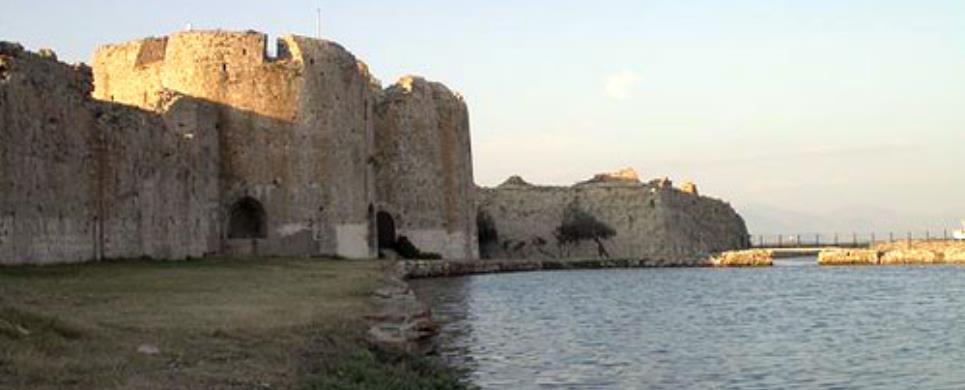
RIO (Port) PATRA
Tel: +30 2610 990691
Fax: +30 2610 623005
In 1499 the first fortification
of the pass was made by Bayazid II, smaller in area and with a
double circuit and moat.
In 1532 it was taken by the Spaniards and Andrea Doria, and retaken by the Turks. In 1603
the Knights of Malta wrought significant destruction. In 1687 it was taken by Morosini. Drastic
repairs were made and it received the
form it has today: new towers - bastions,
strengthened ramparts. The fortress was siezed by the Turks in 1715, and in 1828, after a siege,
the Turks surrendered it to General Maison.
It was repaired and handed over to the Greeks.
The Fortress
was used as a prison for a considerable time. During World War II the Germans established themselves there.
The text is cited from The Hellenic Ministry of Culture & Tourism WebPage
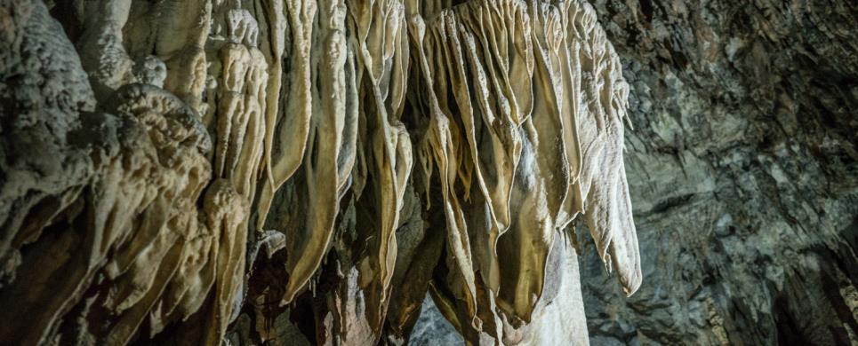
KASTRIA (Village) KALAVRYTA
Tel: +30 26920 31633
Fax: +30 26920 31588
In the village Kastria of Achaia,
60km from Tripoli (tunnel
at Artemision) and 9 Km from
Kleitoria, lies the famous
“Cave of the Lakes”.
It is a rare creation of Nature. Apart from its labyrinth of corridors,
its mysterious galleries and its strange stalactite formations, the “Cave
of the Lakes” has something exclusively unique that does not exist in other
well known caves. Inside the cave there is a string of cascading lakes forming
three different levels that establish its uniqueness in the world.
The cave is an old subterranean river whose explored length is 1980
meters. In winter when the snow melts, the cave is transformed into a subterranean
river with natural waterfalls. In the summer months, part of the cave dries up
revealing a lace-work of stone-basins and dams of up to 4 m. in height. The rest
of the cave retains water permanently throughout the year in 13 picturesque lakes.
TOURIST ROUTE
The developed part of the cave is currently 500 meters long. It includes
artistic lighting. The visitor enters the cave through an artificial tunnel which
leads directly to the second floor. The dimensions of this part of the cavern
create awe, rapture, admiration. The passage from lake to lake is possible by
small man-made bridges.
PALEONTOLOGICAL INTEREST
At the cave’s lower floor, human and animal fossils
were found, among which that of a hippopotamus. This part of the cave is intended
to become a biological cave laboratory of international standing.
THE CAVE’S LEGEND
The legend says that the daughters of Proitos, king of Tirynth, Lyssippi,
Ifinoy and Ifianassa, bragged that they were more beautiful than the Goddess Hera
and scorned the worship of the God Dionysus. Zeus’s mate didn’t forgive
their vanity and took their sanity, causing them to believe that they were heifers
running wild on the mountains and meadows of Peloponnisos,
infecting the women of Argolida
with the craze of infanticide. Someday they arrived at the cave of Aroanios
were they were found by Melambodas who cured them. He then led them to the village
Loussoi.
EXPLORATION - DEVELOPMENT OF THE CAVE
In 1965, the residents of the valley of Kastria reached for
the first time the second floor, using wooden ladders from a 9 meter ramp. The
cave was explored by the E.O.S. (Hellenic Alpine Club) with the help of Prof.
I. Melendis and mapped by the E.S.S. (Hellenic Speleological Society) under the
supervision of Mrs. Anna Petrochilou. The development of the cave began in 1981
by E.O.T. (Hellenic
Tourism Organization) and continued from the former community of Kastria. Today
the municipality of
Lefkasio is responsible for the cave’s operation and is resided at Kleitoria
(Mazeika).
PETROCHORI (Village) PATRA
The trip on the funicular railway resembles a journey in a dream.
Once the train has left the tranquil, peaceful landscape of Diakofto,
it delves into the deep gorge of the Vouraikos river that runs down from Helmos.Before
long the little train is clutching the rails with its "teeth".
The higher you go the better you appreciate nature' s silent work.
Enormous rocks, boulders gnawed by time, trees hanging from the mountain slopes
call forth awe and admiration.
The first stop - pause for breath - is at Trekilia for a quick cup
of coffee; then on to the village of Zahlorou at an altitude of 642 m.
This traditional village possesses a rare natural beauty.
The town of Kalavrita,
the third stop on the funicular, is spread out on the slopes of Helmos at an altitude
of 750 meters.
Numerous tall plane trees offer their welcoming shade. They line the
streets like an arcade.
The charming houses, streets, trees all make you feel right at home.
The town exudes tranquillity. Just outside town a Venetian fortress, "the
castle of Orea", stands atop a bluff.
This text is cited December 2004 from the West Greece Region General Secretariat URL below, which contains image.
ELEOCHORI (Village) PATRA
Traditional building of the 19th c. with carved adornments.
ACHAIA (Prefecture) GREECE
Patra,
the capital of Achaia, is an important commercial, financial and cultural centre
as its port is Greece's gate
to Europe. The city is worth exploring for the imposing church of Aghios Andreas,
its medieval castle
with a wonderful view all the way to the Roumeli Mountains, and the Ancient
Odeon the grandest roman building in the region. The city has an Archaeological
Museum, a Municipal
Art Gallery, and a Folk
Art Museum.
Patra enjoys a lively cultural life. Among the numerous events organised,
two deserve special mention: the carnival, which is the great cultural event of
the winter, and the International Festival, which draws thousands of visitors
in the summer. Near the present-day village of Araxos
is the ancient wall of Dimaion; while in the area of Arla
is the wellpreserved medieval castle of Gyftokastro.
East of Patra stands the famous castle
of Rio and further along a beautiful stretch of coast lies Aigio.
From the square of Psila Alonia one can admire a spectacular view towards the
Gulf of Corinth, and the
attractive neo-classic buildings of the architect Tsiller. After the shrine of
Panaghia Tripiti (patron saint of Aigio), one can visit the local archaeological
and folk museums. In the wider region it is worth taking a look at the monastery
of Taxiarchon (try the tempting rose-petal sweet), and the pleasant fir forest.
From Diakofto
the famous small funicular railway climbs up the imposing Vouraikos
gorge to Kalavrita.
Alternatively one can take the road and stop off at the monastery
of Megalo Spileo which is built into a cave and dates from 326 AD. The monastery
has a miracle icon of the Holy Virgin. A little out of Kalavrita one can visit
the memorial site of the World War II massacre of its townsmen, the Castle of
Oria, and the monastery
of Aghia Lavra where the banner of independence was first raised in 1821.
The fully equipped ski centre is only 12 km away and turns the sleepy town of
Kalavrita into a cosmopolitan place in the winter. The famous Caves
of the Lakes are only 16 km away at Kastria. Well worth a visit are the trout
farms at Planitero, a forest
of plane trees at the springs of the Aroano river.
On route 111, after Dafni,
is the artificial lake of Ladona
and picturesque villages such as Vesini
and Dechouni. Pretty traditional
villages can also be found in the municipality
of Aroania.
This text is cited December 2004 from the West Greece Region General Secretariat URL below, which contains image.
PATRA (Town) ACHAIA
It is the central square of the city. It used to be called Kalamogdarti,
because this is where it was located Kalamogdarti's residence. Its formal name
was "Othonos". After 1862, it was called National. But when King George I ascended
the throne, the square was named after him. It took its current appearance in
1902, when it was smoothened and planted. It was a place, where national dances
and outdoor meetings, mostly of political content were held. It was the square
on which all the cafes and the shops were gathered. In 1875 the two fountains
were placed which cost 70000dr each. A huge amount of money for the economic potential
of Greece and Patras back then. It was the square of the political and cultural
being of the city, the place where the most important activities were taking place.
In the cafes around the square Italian singers sung. This fact should be a surprise
as Patras of the Belle Epoque constituted an important cultural city and its contact
with the West was frequent and of high level. We should not neglect that the Opera
Concerts were held at the theatre next to the square, the famous "Apollo" Theatre.
The contemporary George Square still constitutes the square of political meetings,
demonstrations, cultural activities and mostly carnival celebrations.
This text is cited Apr 2003 from the Municipality of Patra URL below, which contains image.
It is the square that carries the name of king George's wife, Olga.
It used to be called Omonoia Square. It is worth referring that on this square,
Kostis Palamas used to play as a child, because he used to live just across, on
Korinthou street, at the crossing with Kolokotroni street. According to the city
planning it was intended to be the market of cereals, but then it was planted
with trees and was named "The Queen's Garden". Today, this square is called "National
Resistance Square".

This particular square bears the name of the Three Alliance Forces
with Greece in the fight for liberation. These forces were England, France and
Russia. This square's old name was Custom Square, because it lied beside the Custom
House.
It is considered to be the best square in Patras. It was a hill, wide on top. There used to be raisin fields, at a higher level in comparison to the raisin plantations. The area from Ipsila Alonia Square up to the St Catherine Cathedral was called "Elliniko", because of the great number of archaeological finds. In 1857 the levelling of the square begun and ended in 1881, while mayor of the city was Benizelos Roufos, after whom it was named then. Before that its name was Arta Square. In 1863 the National Guards took their oath there. In 1883 was constructed a platform for music and were placed 15 crystal torches. On the north side of the square there was a place for sheep to pasture. At the lower part there were butchers' shops. In 1905 the square had 5 cafes that stayed overnight. This is a clue for the plenitude and 24-hour basis entertainment and amusement of the people in Patras. On November the 22nd, 1821, the Turks chased the Greeks up to this square. King George VIII had bought an area of 25 acres at the south side of the square in order to build a mansion. This, of course was never accomplished as the king's son that inherited this land sold it. In 1944, on this square, the German Army of Occupation hanged fighters of the National Resistance. On March the 3rd, 1923, took place the ceremony for the unveiling of the bronze statue of the Metropolitan Palaion Patron German and on March the 23rd, 1953 the reveal of Palamas' bust.
This text is cited May 2003 from the Municipality of Patra URL below, which contains image.
It is about a square almost at the end of Ermou street. In that area
there has been a market since antiquity. Markato comes from the Latin word Mercurius
(Ermis). This means that this is Ermis Square, the market square. It is possible
that it was named after the liberation from the people of Keffalonia and Zakynthos.
Though, in order to honour the first governor of Greece, Ioannis Capodistrias,
on a decision made by the municipal council, it has been renamed into Kapodistriou
Square, and a bust of the governor stood there.
This square was named after Thomas Voud, who arrived in Patras in
1843 from England, and because of the economic growth of the port, due to the
selling of raisin, he was put in temptation and decided to get engaged in this
particular business. In 1894, he died, while being consul of England in Patras.
He directed the major raisin house of Barf. The area around his mansion was named
after him. Now this square has changed its name into Fighters Square of 1821,
as a tribute to the fighters of the glorious Independence War.
This square carries the name of the family that lived there, Maroudas
family. At first, it was called Giannia Square, to honour George Giannias, or
Deligiorgi of Giannia. On April, 1821, the Turks attacked Giannia and suggested
that he should surrender, but he and his mates denied. In popular songs there
is reference in Giannia's feats.
Tel: +30 2610 580100
Fax: +30 2610 325051
On a green-clad hill, eight km southeast of Patras'
centre, are located the facilities of Achaia Clauss winery, distinguished as one
of the topmost tourist sites of the region.
Its founder, Bavarian Gustav Clauss arrived in Patras in 1854 to work
in a German company dealing with exportation of raisin. During an excursion, he
visited this region that charmed him with its natural beauty. He bought a small
vineyard just to produce some wine for self-consumption and he ended up to the
establishment of this Castle-Winery that survives intact till now. In 1861 he
founded Achaia Clauss Co and the excellent quality wines, including Mavrodaphne
of Patras, conquered both Greek and international market.
The stone-made buildings, the large oak carved barrels with one century-old
Mavrodaphne, the traditional cellar where visitors are welcomed as well as the
unique landscape with the breathtaking view attract approximately 200,000 visitors
per year.

Receive our daily Newsletter with all the latest updates on the Greek Travel industry.
Subscribe now!
