Listed 100 (total found 160) sub titles with search on: Sights for wider area of: "CHANIA Prefecture CRETE" .
AGIOI THEODOROI (Rocky island) PLATANIAS
Opposite the beach, the small island of Thodorou is the home for a
number of the protected wild goats (kri-kri) of Crete. No one is permitted on
the island.
This text is cited Oct 2002 from the Crete TOURnet URL below, which contains image.


AMOUDARI (Village) SFAKIA
Askifou is 52km south of Chania on the Chania - Hora Sfakion road.
It is at 730 metres altitude, and has characteristic Turkish towers on a hill
in the middle of the plateau. The Lefka Ori surround the plateau with the high
peaks of Kastro on the west (2,218m), Tripali on the east (1,493m), and Agathes
(1,511m) giving it the appearance of an amphitheatre. The plateau of Askifou was
probably a lake in prehistoric times and the fertile patchwork fields yield wheat
and potatoes. On this plateau in 1821 there was a major battle between the Turks
and the Sfakiani revolutionaries that resulted in a victory for the locals. The
fierceness of the battle and the heroic fighters are still remembered in local
songs. You may rent rooms in the middle village, Amoudari of Askifou. You may
also eat the local Sfakia pita, delicious kefalotiri cheese, and local thymari
(thyme) honey in the pleasant village square. A statue to a local revolutionary
hero Polentas has recently been erected here and to Tsontas, a hero from the Macedonian
conflict in the 1900s.
This text is cited Nov 2002 from the Crete TOURnet URL below, which contains images.
The Krapi Plateau is on the road to Sfakia from Chania, before Askifou
Plateau.
The Lefka Ori surround the plateau with the high peaks of Kastro on
the west (2,218m). Above the Askifou Plateau, in Tavri, near the plateau of Niatos
(1200m), there is a Mountain Refuge (Information: Mounainteering Club of Chania).
The area of Askifou offers many walks for nature enthusiasts.
ANOPOLI (Village) SFAKIA
From the plateau of Anopolis one has an exceptional view of the south
side of the Lefka Ori. Climbs of the highest peaks of the Lefka Ori, at 2,500
metres, start from here. The view of the mountains is particularly impressive
in the spring when they are covered in snow. The area is protected from the north
winds and it has very mild weather all winter. This area of the Lefka Ori is also
famous for its rare wild flowers that can be seen in the spring.
This extract is cited Nov 2002 from the Crete TOURnet URL below, which contains image.
APTERA (Village) CHANIA
Aptera commands an impressive view of Souda Bay. From the fort you have a good view of the entrance of Souda Bay and also an aerial view of the other Venetian fort, (known by its Turkish name) Itzedin, below Aptera.
Looking south across the valley of Stylos, you will enjoy the view of the Lefka Ori. The view is quite breathtaking from here in the spring when the White Mountains are covered with snow.
CHANIA (Town) CRETE
The neighbourhood of Halepa rewards the visitor with several interesting
buildings, including the residence of the celebrated prime minister of Greece,
Eleftherios Venizelos; the house of the first governor of Crete; the Russian-styled
church of Agia Magdalini on Dagli Street; Galiki Skoli, a former convent which
is now part of the Technical University of Crete; and the Tabakaria, a traditional
leather processing area on the seashore.
This text is cited Nov 2002 from the Crete TOURnet URL below, which contains image.
MESKLA (Village) MOUSSOURI
The village of Meskla is very pleasantly situated between green hills
in the Keritis Valley, has a river going through it, and the Lefka Ori as a background.
The mountain views and the views of the valley down below are breathtaking.
OMALOS (Plateau) CHANIA
At 1,080 metres in altitude, the plateau of Omalos is one of the three
highest large plateaus of Crete. The plateau of Nida in Psiloritis is at 1,400
metres and Niatos, above Askifou, is 1,500 metres high. The plateau has three
exits. The first one is the road from Chania. The entrance to the plateau (1,087m)
on this road is called the Neratzoporta --The Orange Door. The second exit is
the Samaria Gorge, which ends at Agia Roumeli. The third exit is in the southwest
corner of the plateau. The road from here reaches Sougia through wild and captivating
scenery. The plateau is surrounded by the peaks of the Lefka Ori: Volakias (2,116m);
Gigilos, in front of Xiloskalo (2,081m); Samberos (2,005m), on the west side of
the Samaria Gorge; and Psilafi (1,984m). The plateau is roughly triangular in
shape and each side is about an hour's walk. During the winter months, snow may
cover Omalos and the road may be closed for several days. The Omalos Plateau is
green except in midsummer and is covered by wild flowers in the spring. The physical
beauty of the area is as exhilarating as the mountain air and the plateau is a
marvellous area for mountain hiking or walks. On the plateau there are tavernas
and hotels, some of which are equipped for winter stays.
This text is cited Nov 2002 from the Crete TOURnet URL below, which contains images.
POLYRRINIA (Ancient city) CHANIA
The view from the ancient city is exceptional. To the north, one can
see the sea of Kissamos Bay and to the south the dramatic formations and gorges
of the mountains, which are covered in flowers in the spring.
This text is cited Oct 2002 from the Crete TOURnet URL below, which contains images.
STYLOS (Village) ARMENI
Looking south across the valley of Stylos, you will enjoy the view
of the Lefka Ori. The view is quite breathtaking from here in the spring when
the White Mountains are covered with snow.
VRYSSES (Village) KRYONERIDA
The Greco-Roman bridge in Vrises is on the Vrisakos River, east of
the town, at the exit of Vrises towards Rethimnon, under the new highway. The
location is known by the name Elliniki Kamara (Greek Arch) and is beside a church
north of the road into Vrises. The bridge, usable today, is made of dry stone
covered with pebbles and stands 6.4 metres above the river.
This text is cited Nov 2002 from the Crete TOURnet URL below, which contains images.
CHANIA (Town) CRETE
Tel: +30 28213 40100-2
Fax: +30 28213 40201
The residence of the first governor of Crete is between the Venizelos
home and the Galiki Skoli.
This is the last building on the west side of a complex of 17 shipyards. Construction of the building was begun in 1585 by the Commissioner General Alvise Grimani. The thickness of its walls, its isolation from the rest of the "Neoria", as well as the public services which were periodically housed there may account for the name "Great". The second floor, constructed in 1875 housed the school of the Christian Community. When restoration finishes it will be used by the "Mediterranean Centre of Architecture".
This text is cited Sep 2002 from the Municipality of Chania URL below, which contains images.
The need for the presence of the Venician fleet in Crete forced Venice to build shipyards, (Arsenali or Neoria) where the ships were repaired in winter time. The south complex was completed in 1599, with the construction of 17 Neoria. In 1607 the construction of five more Neoria begins on the eastern basin of the harbour. These are known as the Moro Neoria and only two were ever completed. Today only 7 survive out of the 17. In their original form they were open on the side of the sea. The ceilings are arched, and they are connected with arched openings of the same thickness as the walls.
This text is cited Sep 2002 from the Municipality of Chania URL below, which contains images.
In Chania harbour there is the Great Arsenale. This arsenal's second floor was
used as a Town Hall and as a Mayor's residence during the Venetian era. The city
and the University are presently making plans to restore the Arsenale.
The Market, impressive for its size and shape, was built on the remains of the bulwark Pietta Forma. The construction survey was commissioned to K. Thranthakis. The structure is in the shape of a cross with 76 shops grouped according to their wares in the four arms of the cross. The south facade is particularly well constructed out of chiselled limestone, in the architectural style of the local tradition, developed during the Venetian period. Construction was completed in 1913 and the formal opening was made by Eleftherios Venizelos on 4th December 1913 as part of the celebrations for the Unification of Crete to Greece.
This text is cited Sep 2002 from the Municipality of Chania URL below, which contains images.
The covered market is in the centre of the city on busy Odos Hatzi
Michali Yannari. Behind the market are the old Venetian and Turkish parts of the
city, while in front is the modern commercial centre of Chania. The city market
(agora) of Chania is prominent on the main east-west street of Chania and dates
from the beginning of the century.
A cruciform building modelled on the market at Marseilles, it stands in the place
of the main entrance of the Venetian fort that surrounded the city. Materials
from the fort were used to build the market. The market celebrated its eightieth
anniversary in 1993. The site that the market occupies is that of the former Venetian
Pittafora Bastion. West of the market's front door are some of the bastion's remains.
Near these remains the large and imposing Rethimnon Gate, the main entrance to
the old city, once stood.
The Public Market of Chania has many grocery shops, as well as bakeries, meat,
fish, and cheese stores. Many shops sell the local, well known, Cretan herbs.
There is also a variety of restaurants and cafes frequented by the Chaniotes,
as the people of Chania are called, during the day. The market has a lively atmosphere,
especially on Saturdays.
This text is cited Nov 2002 from the Crete TOURnet URL below, which contains images.
Important specialized building, erected in the period of the Cretan State. It is cross-shaped in plan, influenced by the buildings of the so-called Iron Age of the 19th century, which characterizes the period of the Industrial Revolution. The building is distinguished by its elegance and good balance and preserves in schematic form the typical features of the late Neoclassicism.
The building of the Market was founded on April 14, 1911 by the Municipal Manolis Mountakis and was inaugurated on December 4, 1913 by the Prime Minister, Eleutherios Venizelos, during the celebration of the Union of Crete with Greece. Since then it has been used as the town's public market.
This text is cited Feb 2003 from the Hellenic Ministry of Culture URL below, which also contains image.
Public baths - Hamams constitute a very old Moslem tradition, brought by the Ottomans of Asia Minor and spread throughout their domain. According to the Koran only running water can purify. On the whole, body hygiene was closely associated with worship and meditation. The Hamam is situated on Halithon Str., near the place where a Roman Bath used to be, and is decorated with beautiful mosaics. It is a multiple-domed structure with an arcade on the perimetre, which was demolished in 1941. The Hamam was built on the site of the Venician Monastery of St. Clara opposite St. Francis.
This text is cited Sep 2002 from the Municipality of Chania URL below, which contains image.
Construction was begun in the late years of the Turkish occupation in order to house a military hospital. The building complex consists of several wings in the form of a free rectangle, surrounding a central court with free access from the facade. Both this complex and its morphology greatly affected the design of the modern city and the planning of some key road junctions, as well as the circus opposite the facade. The building was renovated after a destructive fire in 1936, and a third floor was added to the central part.
This text is cited Sep 2002 from the Municipality of Chania URL below, which contains images.
Tabakaria grew into a district of leather processing houses on the rocky eastern side of the city, beyond the walls, in the middle of the 19th century. This area was chosen for the following reasons : the abundant brackish subterranean waters used to soften leather, and its relative closeness to the city. Today some of the leather processing houses are still in operation. Adjusted to the natural properties of the land, the buildings have only one floor on the side of the street and two or three floors on the side of the sea. They are made of stone with tile roofs. They are built close to each other with very narrow, steep passages and steps going down to the sea. They constitute a unique architectural complex.
This text is cited Sep 2002 from the Municipality of Chania URL below, which contains images.
MOURNIES (Small town) ELEFTHERIOS VENIZELOS
Mournies is the village where Crete's famous statesman Eleftherios
Venizelos was born. The house is on the main street and is now a museum.
STERNES (Village) AKROTIRI
In Sternes there is a large Venetian structure as well as remains
of Venetian houses.
THERISSO (Village) CHANIA
The Eleftherios Venizelos Centre for Independence is in Therisos.
In 1905, Venizelos, the revered Cretan politician, set up a revolutionary assembly
here demanding immediate union with mainland Greece. As a result of this assembly
and the ensuing riots, Prince George, the High Commissioner of Crete, resigned.
Finally, in 1913, Venizelos's dream of union with Greece was realised. The house
(his mother's) is to the left in the middle of the village, and has been preserved,
but no official status is given to it.
This text is cited Oct 2002 from the Crete TOURnet URL below, which contains images.
AGIA ROUMELI (Village) SFAKIA
On the west side of the south end of Samaria Gorge, on top of a hill,
are the remains of a Turkish castle.
CHANIA (Town) CRETE
The fort still known with its Turkish name, Firca (Firka = barracks) was built in order to protect the entrance of the harbour. A thick chain from Firca to the base of the light-house closed the harbour in case of siege. The fort was the headquarters of the Military Commander of the city. The inside area was divided into barracks and ammunition warehouses. The buildings of the west wing have two-floors with dome covered rooms. Over the door of the first floor there is the following inscription : "ALOYSIUS BRAGADEUS PROVISOR CYDONIAE M. DCXX". In the centre of the court, there is a large water reservoir, where the water running from the roofs was collected. In the period of the Turkish occupation and until fairly recently, Firca was used as military barracks and a prison. The flag of the Unification of Crete to Greece was symbolically raised on the corner watch-tower on 1st December 1913.
This text is cited Sep 2002 from the Municipality of Chania URL below, which contains images.
The Firkas Bastion is at the western end of the outer harbour. It now houses the Naval Museum. The Venetians used it as a prison for Greeks condemned to death. Eleftherios Venizelos and King Constantine officially raised the Greek flag here in 1913. During the summer months, the Firkas is host to a local Cretan dance group that gives public performances. Plays and concerts are also performed here.
This text is cited Nov 2002 from the Crete TOURnet URL below, which contains images.
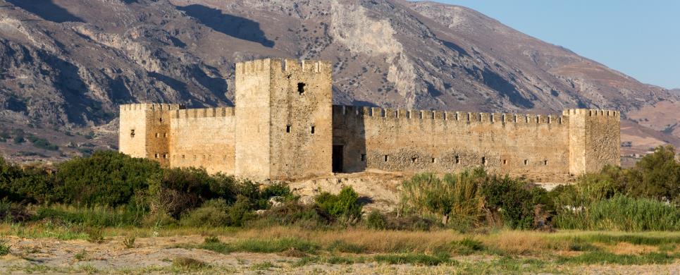
FRANGOKASTELLO (Castle) SFAKIA
Tel: +30 28210 56119, 53033
Fax: +30 28210 56118
The Venetian fortress
was erected by the rulers of the island in 1371, in order to protect the small bay from the pirates. However it was barely used for
defensive purposes during the Venetian era and on the eve of the Turkish attack, it was actually abandoned. In 1828 the Cretan
rebels occupied the fortress and during the siege that followed, its towers were destroyed.
The fortified castle is a typical example of the Venetian defence architecture with a rectangular shape with
towers on each side.
Over the gate, one sees a relief with the Lion of St Marcus and the Venetian crowns. The buildings in the interior, as well as the
battlements, were constructed during the ottoman occupation; at the same time many repairs were carried out. Underneath the fortress,
there are the ruins of the church of St Marcus.
According to tradition, during the second half of May and with a specific weather, shadows of the armed cretan warriors,
who lost their lives there, seem to march towards the fortress. The locals call them "Drosoulites". Near the fortress, is the church of
St Niketas of 1371, where there are traces of an Early Christian basilica. The works of restoration and consolidation were carried out by
the 13th Ephorate οf Byzantine Antiquities.
The exterior of the Venetian fortress (1371) has survived in excellent condition although the interior is in ruins. It has a square design with a tower at each corner. Above the gate is the emblem of Venice, the lion of St. Mark. The Venetians built the castle to deter pirate raids and to bring some order to this area. The castle is associated with some fierce battles. In 1828, a small band of Greeks, headed by Hatzi Michali Daliani, occupied the castle in an attempt to spread the War of Independence to Crete. He and his small band of rebels were massacred by the much larger Turkish force on the plain of Frangokastello. Their martyrdom became the subject of heroic legends and songs. The local legend says that on or around the anniversary of this battle (17 May), you can see the ghosts of Daliani and his army. They appear in the early morning, marching from the castle. These spirits are called "dhrosoulites" or "dew shadows" by the locals.
This text is cited Nov 2002 from the Crete TOURnet URL below, which contains images.
IMERI GRAMVOUSSA (Island) CHANIA
KISSAMOS (Town) CHANIA
The name Kastelli came from the Venetian castle that was in the town
but the town's formal name is Kissamos. The bombing of World War II mostly destroyed
the castle.
This text is cited Oct 2002 from the Crete TOURnet URL below, which contains images.
KYRIAKOSELIA (Settlement) ARMENI
In the village of Kastelli, at the top of the valley, you may walk
to the summit of the hill (15 min.), to see the Byzantine fort of Kyriakoselia.
Inside the walls behind the new church there are reservoirs and wells and the
remains of the original Byzantine church of Agia Paraskevi.
PALEOCHORA (Small town) CHANIA
In Paleohora, the Venetians built a fortress in 1282 and called it
Castle Selino, the name of the district today. The pirate Barbarosa destroyed
the fort in a raid in 1539 but the outside of the fort is still well-preserved.
This text is cited Oct 2002 from the Crete TOURnet URL below, which contains image.
At this location many Venetian maps present the Fort called Selino - Kasteli. The fort was built in 1280-82 and for its favor all the country was renamed from "Orina" to "Selino". The fort was destroyed by the Romans of the Crete in 1332. It was rebuilt in 1334 by the Venetians and under the Fort they founded a new settlement for workers and merchants, that took the name Vourgos. The pirate Barbarosa destroyed the fort in 1539, but later in 1595 Dolf revamped it.
This text is cited Jan 2004 from the Interdynamic S.A. URL below, which contains image
ARKOUDOSPILIA (Cave) AKROTIRI
The cave of Our Lady of the Bear (Spileo Arkoudas) is on the path
from Gouverneto to Katholiko. The chapel dedicated to the Virgin is inside the
cave. At the rear of the cave there is a grey bear-shaped stalagmite with a small
pond in front of it. Local legend says that the Virgin Mary turned the bear to
stone after she caught it drinking the monks' water. Archaeologist claim that
in antiquity the cave was a shrine to Artemis, who was transformed into the shape
of a bear. On the first day of February local people come in the evening for the
church service and stay in the cave afterwards to celebrate with food and wine.
This text is cited Oct 2002 from the Crete TOURnet URL below.
KOURNAS (Village) GEORGIOUPOLI
Between Kournas Lake and the village of Kournas, at 4.8km from the
intersection with the highway is the cave of Kournas with an excellent view of
the lake. The cave is not big, 35 metres in depth, but it has many stalactites,
stalagmites, and natural pillars. The cave may be reached by a path from the main
road.
This extract is cited Nov 2002 from the Crete TOURnet URL below, which contains image.
MARATHOKEFALA (Settlement) KOLYMBARI
Ioannis Xenos (St. John the Hermit) was the saint who founded the
Katholiko Monastery on the Akrotiri. There is a stalactite in the rear of the
cave which people consider to be holy.
This text is cited Oct 2002 from the Crete TOURnet URL below, which contains image.
STAVROS (Port) AKROTIRI
There is a cave in the hill, which was used from Neolithic times.
Evidence exists of its use as a sanctuary from the end of the Bronze Period through
all the Greek periods.
TOPOLIA (Village) MYTHIMNA
Just south of Topolia is Agia Sofia Cave with many stalactites and
the little chapel of Agia Sofia. Ancient remains have been found in the cave dating
as far back as the Neolithic era.
This text is cited Oct 2002 from the Crete TOURnet URL below, which contains images.
LISSOS (Ancient city) PELEKANOS
Lissos was originally a harbour of Elyros (near Rodovani), became
very rich and had gold currency. It was an important city in the Doric, Roman
and Byzantine periods.
AGIOS IOANNIS (Village) SFAKIA
The road from Aradena to Agios Ioannis goes through a very attractive
pine forest, one of the very few in Crete, and it has a view of the clear waters
of the Libyan Sea from high up and the bulk of the Lefka Ori from the south.
ALIKAMBOS (Village) KRYONERIDA
As you approach the village, you will see a Venetian fountain which
is still used today to water animals.
AGIA IRINI (Settlement) ANATOLIKO SELINO
The gorge is 8km long and 45-500 metres deep, in a forested area with
steep mountain cliffs, and is easy to walk. In 1866, 1,000 women and children
escaped from the Turks through this gorge.
AKROTIRI (Municipality) CHANIA
Among the 115 caves and 5 small gorges of the promontory the small
verdant gorge of Katholikou or Avlaki Agiou ("The saint's way") distinguishes
itself in its wild beauty. After reaching the well-known Convent of Gouvernetou,
situated at an altitude of 260m. and a distance of 16 km from Chania,
you start walking northwards on a pathway and, after 10 minutes, you meet the
Cave of Panagia Akroudiotissas, as well as the chapel of the Virgin Mary and the
sanctuary of Artemis. After walking for 10 minutes downwards, you can see the
monastery of Saint John the Hermit, who lived during the 14th century in the 151
m long and very nice cave that is situated in the vicinity of the chapel.
A little further downwards, after walking over an unusually big bridge,
you enter the gorge. You then walk on the streambed for about half an hour and
reach the coast. You can see is very clean for swimming. You can see a Venetian
well, a construction where the monks of Katholikos used to keep their small craft,
and the stone portion that was cut off for the building of the Convent.
This text is cited April 2003 from the Prefectural
Committee for the Promotion of Chania pamphlet.
ANOPOLI (Village) SFAKIA
It is another of the densely wooded worth visiting gorge of Sfakia
with high precipices.
From the mountain village of Anopoli you can start walking on the
rural-mountain road leading to the White
Mountains, while reaching an altitude of 2000 m near their highest summit.
After walking for one hour and a half, a small ramification leads rightwards to
the Byzantine chapel of the Rood that contains remarkable murals. You can drive
up there too.
It takes about 3 hours to walk up to the exit of the gorge, where
there is an asphalt road leading from Chora
Sfakion to Anopoli. A few meters downwards , there is a very clean beach called
Iliggas, where you can enjoy swimming in the Lybian
Sea.
If you can't make the above crossing, you can have a global view of
the gorge by walking as much as you wish toward the inside of the gorge from its
exit on.
This text is cited April 2003 from the Prefectural
Committee for Tourism Promotion of Chania pamphlet.
ARADENA (Settlement) SFAKIA
The impressive gorge of Aradena starts from the Lefka Ori north of
the village of Aradena, and ends up in the sea, south of Aradena. You may walk
down through the Aradena Gorge and exit near Marmara on the south coast. There
is a path from Aradena that allows you to descend into the gorge. The walk may
take 3 to 4 hours as it is 7km from the Aradena entrance to the sea. You should
not attempt the walk without ample water, boots, and arrangements to be picked
up at the walk's end. A path at the bottom goes to Marmara beach, Finikas, Loutro,
and Hora Sfakion. The coastal path is narrow and quite dangerous in places between
Loutro and Hora Sfakion. Alternatively, you can walk to Loutro and take the boat
to Hora Sfakion.
This text is cited Nov 2002 from the Crete TOURnet URL below, which contains images.
ASFENDOS (Village) SFAKIA
In the east of Sfakia
there is the gorge of Asfendou, which has its entrance in the almost deserted
mountain village of Sfakia called Asfendou (at an altitude of 770 m and a distance
of 8 km from Imbros)
You reach the gorge by coming from the area of Ambelos - Tentas -
Seli and after walking for 3 hours, you meet the old village of Agios
Giorgos (former Kolokasia) situated at an altitude of 260 m. The 1700 m long
rural road will lead you from there to the main road of Chora
Sfakion - Fragokastello
and to the new village of Agios
Nektarios, 73 km distant from Chania
and 7 km from Chora Sfakion.
This text is cited April 2003 from the Prefectural
Committee for Tourism Promotion of Chania pamphlet.
CHANIA (Prefecture) CRETE
Chania is a blessed and privileged place with a mild climate during
the whole year, countless beauties and all kinds of attractions.
Apart from its five hundred villages, the area counts more than 100
very clean beaches on the northern and southern coasts, a hundred mountain tops
and about 1500 caves, as well as countless monuments and gorges of incomparable
wilderness and beauty in Europe. More than sixty small and bigger gorges, easy
or difficult of access, are situated in the Prefecture of Chania, and that is
why the city is often called “the Locus of Gorges”.
These gorges, with their wild beauty and unpolluted environment stir
strong emotions of awe and wonderment. The passage of one of these gorges offers
unforgettable experiences and certainly makes you wish to cross another gorge
during a next visit in Chania.
Apart from its wilderness and beauty, Chania presents a number of
other interests also: legends about dragons and fairies, about good and bad spirits
that dwell in the gorges. There are limpid water sources or picturesque Byzantine
churches in such places where famous oracles or pantheons formerly took place.
There are heroic stories about the rebels who, from the gorges, drove
the Roman, Arab, Venetian, Turkish or Nazi invaders out of the Cretan land. Tragic
stories as well, about battles and about thousands of women and children who found
refuge from the aggressors in these gorges, and many other stories.
If you look more attentively, you will distinguish the vestiges of
the people who used to live in the gorges: sheepcotes, water mills and hydro-saws,
lime or coal furnaces, guardhouses erected for defense against the various incursions,
and many other things.
These gorges were mainly formed on carbonic rock beds, i.e. limestone,
marbles and dolomites, as a result of a deep fissure in the earth’s crust and
the corrosive activity of the waters of the rivers. They were formed about 14
million years ago, at the end of the Miocene period of the Cainozoic century.
(Text: Antonis Plymakis)
This text (extract) is cited February 2004 from the Chania
Prefecture Tourism Committee tourist pamphlet.
IMBROS (Village) SFAKIA
The Imbros Gorge starts just south of the village. During World War
II, twelve thousand soldiers evacuated the island walking through the gorge to
the south coast of Crete under aeroplane fire. There they were taken by the Royal
Navy to Egypt. The Imbros Gorge is very narrow in certain parts, with impressive
walls. There is unique flora all year round. It is 11km long, takes 4 to 4 1/2
hours to walk and ends in the village of Komitades.
This text is cited Nov 2002 from the Crete TOURnet URL below, which contains images.
KALIKRATIS (Settlement) SFAKIA
It is situated eastwards the Asfendou
gorge, starting from the mountain village of Kalikratis in Sfakia at an altitude
of 750 m (14 km distant from Imbros)
and you need three hours in order to cross it.
The gorge ends in the village of Kapsodasos
at an altitude of 120 m and at a distance of 8 km from Chora
Sfakion.
This text is cited April 2003 from the Prefectural
Committee for Tourism Promotion of Chania pamphlet.
KATOCHORI (Village) KERAMIES
This gorge is well known as the gorge of Katechori or Stylos as well
and it is one of the few gorges in Chania that does not have a north-south direction.
It is a very beautiful and verdant gorge, with many species of the
Cretan flora and with a lot of steeps. Its crossing is easy, since it is situated
near the city of Chania and
is accessed from the village of Katechori in the Province
of Keramia (at an altitude of 300 m and a distance of 21 km from Chania).
The passage takes three to four hours and ends in the village of Faraggi
(meaning "gorge") (at an altitude of 40 m and a distance of 17 km from Chania),
at a short distance from the Chania -Stylos
main road.
This text (extract) is cited April 2003 from the Prefectural
Committee for Tourism Promotion of Chania pamphlet.
OMALOS (Plateau) CHANIA
It is one of the most remarkable gorges of Sfakia where a few couples
of wild goats still live (the seldom Cretan Chamois).
Its passage starts from the village of Agios
Ioannis in Sfakia (at an altitude of 780 m and a distance of 92 km from Chania).
You need around 1 hour in order to reach the location of Kormokopos, where there
are caves with water, before starting descending the gorge (up to that point,
you need a guide). The gorge ends in the very beautiful piny sand beach of the
Libyan Sea, after another
2 hours' walk. From the beach to Agia
Roumeli, you have to walk one more hour. The above crossing covers half the
gorge. If you wish to cross all of Elygia, you need an experienced guide and at
least 2 days at you disposal. You start from the plateau of Omalos and walk via
the refuge of Kallergi and the summit of Melinataou (at an altitude of 2133 m)
before reaching the location "Potamos" in the White
Mountains. After a vertical descent of 10 m you reach the bottom of the gorge
and walk on up to the coast of the Libyan Sea.
The Omalos-Potami trek takes 6 hours and another 6 hours from there
to the coast.
This text is cited April 2003 from the Prefectural
Committee for Tourism Promotion of Chania pamphlet.
This gorge is one of the biggest and most difficult of access in Chania,
which requires a guide to be crossed, and at least one and a half days available.
The first afternoon you can climb up (via the plateau of Omalos at an altitude
of 1200 m) the mountain of Grigkilos, very precipitous mountain with alpine configuration.
You pass under a natural arch at an altitude of 1400 m from the frozen water source
of Linoseli. In order to approach the summit, where you spend the night outdoors
or in the ruined sheepfold of Tzatzimou, you need to walk for 2,30 hours at an
altitude of 2080 m.
The myth says that it is on this summit that Cratagenous Jupiter had
his throne, and westwards, on the nearby more regular peaks, he had his harness
racing. At the source of Linoseli there was a famous ancient oracle as well.
From Gigilo up to the coast, you have to walk for about six hours.
If there is no boat waiting for you there, you will walk for another three hours
(right-and upward from the old village), before reaching the very beautiful littoral
village of Sougia in Selino
(70 km distant from Chania)
There is a wide diversity of fauna and flora species in the gorge,
which is the dwelling place of the Cretan Chamois as well.
You will find a cistern, a goat sheepfold and the chapel of Saint
Nicholas there also.
This text is cited April 2003 from the Prefectural
Committee for Tourism Promotion of Chania pamphlet.
PERVOLAKIA (Village) MYTHIMNA
PRASSES (Village) MOUSSOURI
A small but very beautiful and wild gorge with significant altitude
differences from the entrance to the exit, due to which the walk in the gorge
is sideling enough and takes place among small or bigger rocks and under very
impressive precipitous escarpments.
You reach the beginning of the gorge via the asphalt road leading
from the crossroads of Petra Seli to the plateau of Omalos
(Chania-Sougia
route) and about 1 km from the entrance to the detour of Omalos. On the nearby
dirt road, there is a 1-km long pathway leading to Platanos
after 15 minutes, a densely wooded area with plane trees and ferns and full of
water sources. You thus enter the main portion of the gorge and exit the gorge
after walking for two hours on the rural road leading from the village of Prasse
in Kydonia (31 km distant from
Chania, at an altitude of 480m) to the village of Skidia rightwards. You need
another 40 minutes' walk before reaching Prasse if you do not have any vehicle
at your disposal.
This text is cited April 2003 from the Prefectural
Committee for Tourism Promotion of Chania pamphlet.
SAMARIA (National Park) CHANIA
The Samaria Gorge is the longest in Europe, with a total length of
18km. The width of the gorge is 150 metres at its widest to 3 metres at its narrowest.
Its status as a national park protects its rare flora and fauna. The walk through
the gorge takes between 6 and 8 hours. The path runs downhill but requires strong,
comfortable footwear and some degree of physical fitness.
The gorge begins at Xiloskalo (Wooden Stairs) which, as the name suggests, is
a wooden staircase descending steeply to the river bed through an impressive forest
of trees and exceptional views. At the bottom, near the small church of Agios
Nikolaos, one can relax for a few minutes and enjoy the view. The path then follows
the river bed. Here the mountains tower more than 2,000 metres above sea level.
The highlight of the walk is the Sidheres Portes or Iron Gates. Here the walls
of the gorge are only 3 metres apart and tower to 600 metres on either side.
You can glimpse the blue sea in the distance.
Agia Roumeli lies at the end of the gorge. From here boats take you to Hora
Sfakion where buses transport visitors back to Chania.
This text is cited Nov 2002 from the Crete TOURnet URL below, which contains images.
The gorge of Samaria is the biggest, most imposing and beautiful gorge
in Chania and in Europe, and
that is why it is internationally renown and mostly visited, since more than 300.000
people have the opportunity to cross it each year. It has a wonderful landscape
with rare geo-morphological formations. It is a unique biotope with particular
richness in fauna and flora. It has a rich mythology as well, that goes back to
pre-historical years and a tumultuous history during the difficult years of Crete.
It was proclaimed National Park of the White
Mountains of Crete in 1962,
date at which two or three Sfakian families still lived in the village of Samaria,
in the middle of the gorge, who were mainly busy with cattle-breeding and woodcutting.
The surface covered at the time was 48.500 sq.m., whereas the expansion
of the Park is promoted today on 250.000sq.m. that will include the remarkable
portion of the White Mountains.
The gorge was awarded the following prizes:
•1971: National Diploma of Nature Protection.
•1973: was proclaimed a place of special natural beauty.
•1979: First Order European Diploma of Protection of the Natural Environment
awarded by the Council of Europe, renewable every 5 years. The same diploma was
indeed awarded anew in 1984, 1989, 1994 and 1999.
The length of the passage to the limits of the park is 12.800km and
the distance to the coast of Agia
Roumeli is then another 3.200km.
The gorge can usually be visited from the beginning of May till the
end of October, unless there are bad weather conditions. There are guardhouses
of the State’s Service of the Park (Forest Inspection Service) at the beginning
of the gorge (in the village of Samaria) and at its end. A doctor is also available
to serve the visitors of the gorge, as well as a helicopter airport in Agia
Roumeli.
The gorge has a lot of narrow passes that are called “gates”,
but the narrowest pass, the “Iron Gate”, is 3m wide and 300 to 700m
high from both sides. There are a lot of spots where you can walk over the river
of the gorge on small wooden bridges.
(Text: Antonis Plymakis)
This text (extract) is cited February 2004 from the Chania
Prefecture Tourism Committee tourist pamphlet.
SASSALOS (Village) MYTHIMNA
It is another gorge of Kissamos, wonderful to the nature lovers and
mountaineers, located in an intact natural environment.
It starts from the village of Sasalos in Kissamos
at an altitude of 340 m (57 km from Chania),
where you come to via the Chania-Nopigia-Koleni-Rokka-Sfakopigadi-Malathyro-Sasalo
route.
After walking for maximum 4 hours in the main portion of the gorge,
you reach the village of Malathyro (at an altitude of 315m and a distance of 48
km from Chania). If you walk for one more hour you can also reach the village
of Voulgaro in Kissamos, 7
km distant from the town of Kissamos.
This text is cited April 2003 from the Prefectural
Committee for Tourism Promotion of Chania pamphlet.
SELINO (Province) CHANIA
On the western side of the White
Mountains, in the province of Selino, another gorge opens up, unique in beauties
and flora. The gorge has a lot of vertical passes and bears its name after the
small village situated in the vicinity of its entrance, at a distance of 46km
from Chania.
The gorge is 7,50km long and its crossing takes 3 hours. At the end,
there is a beautiful traditional tourist kiosk.
(Text: Antonis Plymakis)
This text (extract) is cited February 2004 from the Chania
Prefecture Tourism Committee tourist pamphlet.
SFAKIA (Province) CHANIA
Probably the most interesting gorge in flora is the Sfakian Gorge
or Lagko (it is famous as the Gorge or Bartholomew)
You can visit it in two ways:
a) From the Porolagko situated southwards at a distance of 2 km from
Chora Sfakion on the asphalt road to Chania. Up to the end of the gorge, the distance
is 6,5 km and the walking on the watercourse is very smooth and lasts 3,5 hours
including the return. At the end of the passage northwards, on a small elevation,
there is an old sheepfold. You will also meet the little chapel of Apostle Paul
that was built by the Sfakians in 1407.
b) From the village of Imbros in Sfakia you walk for two hours before
reaching the very beautiful cattlemen village called Kali Lakki that has been
abandoned for years now. After walking for about half an hour from there, you
meet the aforementioned chapel of Apostle Paul, and then walk on for another two
hours before meeting the way out to the asphalt road.
This text is cited April 2003 from the Prefectural
Committee for Tourism Promotion of Chania.
pamphlet.
This gorge is the wildest and most difficult of access in Crete. You
need an experienced guide in order to walk through it. At certain points, you
absolutely need a climbing rope for safety reasons and around two days available
in order to be comfortably acquainted with the gorge.
The last portion of the gorge and the coast are called Domata. The
most beautiful and cleanest coast in Crete is situated there, with a sea of wonderful
colours, covered by a very thin and shiny boil and the pine trees of the gorge
reaching out to the coast.
If there is no boat to transport you to Sougia
or Agia Roumeli, you will go on
eastwards with your hard walking for another 3 hours.
This text is cited April 2003 from the Prefectural
Committee for Tourism Promotion of Chania pamphlet.
SIRIKARI (Village) CHANIA
It is a beautiful gorge in Kissamos
that starts from the village of Mesa Sirikari (at an altitude of 500 m and a distance
of 50 km from Chania) on the
Chania - Kalergiana Kissamou
- Kalathenes - Sirikari route.
It ends in Polyrrinia Kissamou
(at an altitude of 400 m), six km distant from the town of Kissamos.
It is wooded with chestnut tress at the beginning, and then with plane
trees, cardoons, wild olive trees, hollies, locusts, lentisks etc., and with aromatic
herbs like the sage burning bush.
Half way you meet the source of "Gra Vrissi" which is full legends,
some of which refer to the "demons" and "goblins" of the gorge. Its crossing requires
3 to 3,30 hours and is fairly easy. At the exit you will find the ruins of the
famous ancient city of Polyrrinias.
This text is cited April 2003 from the Prefectural
Committee for Tourism Promotion of Chania pamphlet.
STYLOS (Village) ARMENI
This gorge is well known as the gorge of Katechori or Stilos as well
and it is one of the few gorges in Chania
that does not have a north-south direction.
It is a very beautiful and verdant gorge, with many species of the
Cretan flora and with a lot of steeps. Its crossing is easy, since it is situated
near the city of Chania and
is accessed from the village of Katechori in the Province
of Keramia (at an altitude of 300m and a distance of 21km from Chania).
The passage takes three to four hours and ends in the village Faraggi
(meaning “gorge”) (at an altitude of 40m and a distance of 17km from
Chania), at a short distance
from the Chania-Stylos main
road.
(Text: Antonis Plymakis)
This text (extract) is cited February 2004 from the Chania
Prefecture Tourism Committee tourist pamphlet.
THERISSO (Village) CHANIA
It is the nearest gorge to the city
of Chania and the only gorge that a visitor can drive through by car of other
transportation means, since it is crossed by a carriageway leading to the gorge
from Chania via the suburb
of the city of Perivolia. The
main portion of thegorge is 6 km long. The imposing precipitous rocky slopes and
the very luxuriant flora have no cause to be jealous of the bigger gorges of Chania.
The gorge, even if visited by car, and the beauty of the village of
Therisso, built at the foot of the White
Mountains at an altitude of 580 m and only 15 km distant from Chania,
will remain unforgettable to the visitor.
The great politician and later Prime Minister of Greece,
born in Chania at the beginning
of the previous century, actualized the Cretan Revolution from the village of
Therisso in order to unite the island
of Crete and the rest of Greece,
after four hundred years of slavery under the Turks.
(text: Antonis Plymakis)
This text (extract) is cited February 2004 from the Chania
Prefecture Tourism Committee tourist pamphlet.
The road to the village of Therisos goes through the gorge, which
is 6km long. A tree lined river follows the gorge, with steep walls on either
side. The area is very pleasant for walking.
TOPOLIA (Village) MYTHIMNA
Beside the road from Topolia to Koutsomatado is the tree-lined gorge
of Topolia with 300 metre high walls.
This text is cited Oct 2002 from the Crete TOURnet URL below, which contains image.
VRASKAS (Settlement) SFAKIA
In the east of Sfakia,
apart from the Gorge of Imbros
there is also a parallel series of very small but interesting craggy gorges directed
eastwards. One of them is the gorge of Kapni.
It is a very wild gorge, difficult of access, with a very precipitous
ground slope. Its entrance is situated on the southern side of the mountains of
Akones and at the fourth km of the asphalt road from Imbros to Asfendou
in Sfakia, at an altitude of 900 m. It ends up in the border of the village
of Vraskas at an altitude of 190 m, and you need 3,30 hours in order to cross
it.
This text is cited April 2003 from the Prefectural
Committee for Tourism Promotion of Chania pamphlet.
ANOPOLI (Village) SFAKIA
Anopolis was a revolutionary centre against the Venetians and was destroyed in 1365. Anopolis, and the province of Sfakia in general, was the centre of revolutions against the Turks in Crete and was never inhabited by the Turks, making it the only free place in Crete during the Turkish occupation. The people from Anopolis had boats and their commercial fleet was based in Loutro. Anopolis is the birth place of Ioannis Daskaloyannis, the leader of the revolution of 1770 against the Turks (statue in the central square). By the time of the revolution of 1770, Anopolis had more than 500 men that could participate in the war. Anopolis was completely levelled during the revolution and many survivors left for other places. The same happened in the revolution of 1867. Due to its position, Anopolis was always one of the last strongholds of Sfakia.
LAKKI (Village) MOUSSOURI
Further on the road to Omalos is a memorial plaque to World War II
resistant fighters killed by the Germans. The New Zealander Dudley Perkins (Kiwi
or Vasili) and his Cretan companion were ambushed near here on 28/02/1944. Their
bravery is recorded in the Cretan folklore and their exploits written in The Cretan
Runner by George Psychoundakis and Vasili The Lion of Crete by Murray Elliot.
Mr. Perkins is buried in the Allied War Cemetery in Souda Bay.
This text is cited Nov 2002 from the Crete TOURnet URL below.
VRYSSES (Village) KRYONERIDA
A monument of a Cretan fighter in the centre of the village commemorates
the revolt of 1897 that led to the autonomy of Crete.
ALIKAMBOS (Village) KRYONERIDA
In Alikambos one can see interesting old village houses with Venetian
remains.
CHANIA (Town) CRETE
The hill of Kasteli is crossed lengthwise by a wide road, the Venician Corso (today Kanevaro str.) At the end of the first vertical street on the north side (Lithinon str), was built the impressive complex of the Government House, "Palazzo". Today only the ground floor, part of the 1st floor, and the entrance to the central court survive. On Lithinon street, the frame of the entrance to the Archive still exists, dated in 1624. The Turkish Government House and the Turkish prison, where several offices of the Technical University of Crete are now housed, are nearby.
This text is cited Sep 2002 from the Municipality of Chania URL below, which contains image.
The site where the Venizelos family house is built was bought by Eleftherios' father, Kyriakos Venizelos in 1876. The style is that of a villa and was finished in 1880. It has two floors and is surrounded by a garden planted with trees and vines. Later it was renovated by Eleftherios Venizelos, who transferred the reception rooms to the ground floor and the bedrooms to the first floor. Today it houses the "Eleftherios Venizelos Institution".
This text is cited Sep 2002 from the Municipality of Chania URL below, which contains images.
The building was constructed in around 1880 as a villa, in the square of Chalepa, the suberb of Chania. It assumed its present form in 1927 when Eleutherios Venizelos himself undertook the task to renovate the house. The outer, south staircase was then abolished and replaced by an open balcony on the first floor and a protected entrance on the ground floor. The reception halls were all housed on the ground floor and a spacious, open balcony was added to the main facade. A typical characteristic of the building was the surrounding area, especially the front garden, which was often taken care of by Eleutherios Venizelos himself.
In 1980 the building was protected by a preservation order. It still belongs to the Venizelos family.
The house was renovated in 1927 by Eleutherios Venizelos. The last restoration was carried out in 1957 by the engineer George Melakis who repaired the interior and several of the installations of the building.
This text is cited Feb 2003 from the Hellenic Ministry of Culture URL below, which also contains image.
The mansion of the Venician-Cretan family Renier is situated on Theofanous str. The largest part of the impressive Renier building complex still survives, though changed by several interventions. Over the arched frame of the entrance the visitor can read the following inscription : MULTA TYLIT, FESTIUE ET STUDVIT DULCES/PATER ET ALSIT, SEMPER REQUIES GERENAT. CDC VIII. IDI. B. IAN (Much was brought, done and studied by the sweet father who laboured and sweated. Let him sleep in serene eternity. The Ides of January.)
This text is cited Sep 2002 from the Municipality of Chania URL below, which contains image.
The building housing the French Embassy in the late years of the Turkish occupation and during the period of the Cretan State, was built by the engineer Leonidas Lygounakis as a home for his son. It was finally given as dowry to his daughter Erasmia, who married the French Consul Blanc. After that it was used as the French Embassy. Today it is the property of the Technical University of Crete and is used as a cultural and conference centre.
This text is cited Sep 2002 from the Municipality of Chania URL below, which contains images.
An exquisite example of the Neoclassical arcitecture during the last decades of the Turkish occupation. It was built in the suberb of Chalepa and is one of the most important buildings of Chania. Built as a typical villa, the house is distinguished by its elegance, the well-balanced volumes and the simplicity of the form. Of special interest is the main entrance opening to the courtyard, with the marble staircase and the porch, as well as the interior decoration of the building.
The building was constructed in 1860 and from 1965 onwards it became the centre of social and philanthropic activity in Crete during the last years of the Turkish occupation and the Harmosteia on the island. It has been proteced by a preservation order.
The building today is abandoned.
This text is cited Feb 2003 from the Hellenic Ministry of Culture URL below, which also contains image.
DRAPANIAS (Village) MYTHIMNA
About 3km out of town there are signs to the Venetian Villa Trevisan. This very beautiful, crumbling structure is between the old road and the new road, outside the village proper. The picture of the villa Trevisan is used on the cover of the book by Giuseppe Gerola (an Italian historical photographer who visited Crete in 1902), on the Venetian remains of Crete.
KALATHENES (Village) CHANIA
In the village of Kalathenes there are the remains of an interesting
Venetian building in the area named Rotonda. It was a villa of a Venetian noble
built on unknown architectural principles. The impressive portal and the courtyard
are still evident. A woman is living in the villa who does traditional weaving
and spins her own wool.
This text is cited Oct 2002 from the Crete TOURnet URL below, which contains images.
OMALOS (Plateau) CHANIA
At the beginning of the plateau proper, on an eastern hill, there
is the house and grave of Hatzi Michalis Yannaris, a famous revolutionary of the
1866 Rebellion. The chapel of Agios Pandeleimonas beside the house was built by
him in thanks for his release from prison.
This text is cited Nov 2002 from the Crete TOURnet URL below, which contains images.
AGIA (Village) THERISSOS
One of the two freshwater lakes in Crete is in Agia. The lake is beside
the road and in the spring is an excellent place for rare flower seekers, bird
watchers and nature lovers.

Receive our daily Newsletter with all the latest updates on the Greek Travel industry.
Subscribe now!


