Listed 100 (total found 369) sub titles with search on: Sights for wider area of: "CRETE Island GREECE" .
AGIOI THEODOROI (Rocky island) PLATANIAS
Opposite the beach, the small island of Thodorou is the home for a
number of the protected wild goats (kri-kri) of Crete. No one is permitted on
the island.
This text is cited Oct 2002 from the Crete TOURnet URL below, which contains image.


AMARI (Province) RETHYMNO
The Amari Valley (Kilada Amariou), southeast of Rethimnon runs from
north to south Crete for 25km. This area is noted for the scenic beauty of its
valleys and rolling hills against a backdrop of the Psiloritis Mountains. The
valley is 400-500 metres above sea level. The peak of Psiloritis (2,545 metres
above sea level) is on the east and Kedros (1,777 metres above sea level) is on
the west. It is a major north-south pass and has seen a great deal of action throughout
history. The Amari Valley is a fertile valley where many varieties of fruit trees
are grown and a great number of well-preserved Byzantine churches may be seen.
This text is cited Dec 2002 from the Crete TOURnet URL below, which contains images.
AMOUDARI (Village) SFAKIA
Askifou is 52km south of Chania on the Chania - Hora Sfakion road.
It is at 730 metres altitude, and has characteristic Turkish towers on a hill
in the middle of the plateau. The Lefka Ori surround the plateau with the high
peaks of Kastro on the west (2,218m), Tripali on the east (1,493m), and Agathes
(1,511m) giving it the appearance of an amphitheatre. The plateau of Askifou was
probably a lake in prehistoric times and the fertile patchwork fields yield wheat
and potatoes. On this plateau in 1821 there was a major battle between the Turks
and the Sfakiani revolutionaries that resulted in a victory for the locals. The
fierceness of the battle and the heroic fighters are still remembered in local
songs. You may rent rooms in the middle village, Amoudari of Askifou. You may
also eat the local Sfakia pita, delicious kefalotiri cheese, and local thymari
(thyme) honey in the pleasant village square. A statue to a local revolutionary
hero Polentas has recently been erected here and to Tsontas, a hero from the Macedonian
conflict in the 1900s.
This text is cited Nov 2002 from the Crete TOURnet URL below, which contains images.
The Krapi Plateau is on the road to Sfakia from Chania, before Askifou
Plateau.
The Lefka Ori surround the plateau with the high peaks of Kastro on
the west (2,218m). Above the Askifou Plateau, in Tavri, near the plateau of Niatos
(1200m), there is a Mountain Refuge (Information: Mounainteering Club of Chania).
The area of Askifou offers many walks for nature enthusiasts.
ANOPOLI (Village) SFAKIA
From the plateau of Anopolis one has an exceptional view of the south
side of the Lefka Ori. Climbs of the highest peaks of the Lefka Ori, at 2,500
metres, start from here. The view of the mountains is particularly impressive
in the spring when they are covered in snow. The area is protected from the north
winds and it has very mild weather all winter. This area of the Lefka Ori is also
famous for its rare wild flowers that can be seen in the spring.
This extract is cited Nov 2002 from the Crete TOURnet URL below, which contains image.
APTERA (Village) CHANIA
Aptera commands an impressive view of Souda Bay. From the fort you have a good view of the entrance of Souda Bay and also an aerial view of the other Venetian fort, (known by its Turkish name) Itzedin, below Aptera.
Looking south across the valley of Stylos, you will enjoy the view of the Lefka Ori. The view is quite breathtaking from here in the spring when the White Mountains are covered with snow.
CHANIA (Town) CRETE
The neighbourhood of Halepa rewards the visitor with several interesting
buildings, including the residence of the celebrated prime minister of Greece,
Eleftherios Venizelos; the house of the first governor of Crete; the Russian-styled
church of Agia Magdalini on Dagli Street; Galiki Skoli, a former convent which
is now part of the Technical University of Crete; and the Tabakaria, a traditional
leather processing area on the seashore.
This text is cited Nov 2002 from the Crete TOURnet URL below, which contains image.
GERAKI (Village) KASTELI
From Geraki one can reach the lovely chapel of Agia Anna, driving through a particularly beautiful landscape. To get there you must take a dirt road for about 13 km, so you can either walk, or else drive if you have a 4-wheel drive vehicle that will stand up to the rough mountain surface.
You will find the view down over the Geraki glen compensates your efforts. A series of different types of landscape meet the eye: rocky parts in contrast to wooded land, sheep. goats and pretty stone-built sheepfolds. Bring some food with you: there is fresh running water by the chapel and the place is ideal for a picnic.
This text is cited Dec 2003 from the Interkriti URL below, which contains images.
IDI (Mountain) RETHYMNO
79 km from Rethymno is the well-known Nida Plateau situated on Mount Psiloritis. Not far from there you will find the Ideon Andron, the cave in which Zeus was housed as a child. On the Nida Plateau, which is used for pasturing during the summer months, you will find the famous "mitata", vaulted stone buildings, in which the shepherds live. Furthermore the Nida Plateau provides skiing facilities during the winter months.
On the Nida plateau, which is used in summer as pastureland, you will find the famous 'mitata', the vaulted buildings made from stone, where the shepherds live. The Nida plateau also offers a ski centre, which is open during the winter months.
The fertile Nida Plateau at 1400 metres height in the Psiloritis Mountains is 24km from Anogia, 78km from Rethimnon, and 60km from Iraklion. In Nida one can see the traditional installations for cheese making, mitata, the skiing centre of Psiloritis, and the cave of Ideon Andron, which is considered to be the birth place of Zeus. There is also a well-marked path from the Ideon Cave by which you can reach the summit of Psiloritis in about 4 hours.
This text is cited Dec 2002 from the Crete TOURnet URL below, which contains images.
On the way to Nida, and in Nida itself, there are the mitata, small round rooms for making cheese. The mitata are made of stone and their roofing is a dome constructed in the tradition of Minoan tombs, e.g. by placing successive layers of stones towards the centre of the circle until it is closed.
This text is cited Dec 2002 from the Crete TOURnet URL below, which contains images.
MATALA (Village) HERAKLIO
Matala is famous for its man-made caves which were first inhabited
during the prehistoric period. Tombs found in the caves date from Greek, Roman
and Early Christian times. The 1960s and early 70s brought an influx of foreigners
to the area and the caves attracted numerous international hippies and other free-spirited
travellers. Today, the Archaeological Service protects the fenced-off caves. The
sandy beach is semi-circular and 300 metres in length. Despite its size the beach
can become quite overcrowded. A path along the rocks will bring you to the "red
sand" beach after a 25-minute walk.
This text is cited Feb 2003 from the Crete TOURnet URL below, which contains images.
MESKLA (Village) MOUSSOURI
The village of Meskla is very pleasantly situated between green hills
in the Keritis Valley, has a river going through it, and the Lefka Ori as a background.
The mountain views and the views of the valley down below are breathtaking.
OMALOS (Plateau) CHANIA
At 1,080 metres in altitude, the plateau of Omalos is one of the three
highest large plateaus of Crete. The plateau of Nida in Psiloritis is at 1,400
metres and Niatos, above Askifou, is 1,500 metres high. The plateau has three
exits. The first one is the road from Chania. The entrance to the plateau (1,087m)
on this road is called the Neratzoporta --The Orange Door. The second exit is
the Samaria Gorge, which ends at Agia Roumeli. The third exit is in the southwest
corner of the plateau. The road from here reaches Sougia through wild and captivating
scenery. The plateau is surrounded by the peaks of the Lefka Ori: Volakias (2,116m);
Gigilos, in front of Xiloskalo (2,081m); Samberos (2,005m), on the west side of
the Samaria Gorge; and Psilafi (1,984m). The plateau is roughly triangular in
shape and each side is about an hour's walk. During the winter months, snow may
cover Omalos and the road may be closed for several days. The Omalos Plateau is
green except in midsummer and is covered by wild flowers in the spring. The physical
beauty of the area is as exhilarating as the mountain air and the plateau is a
marvellous area for mountain hiking or walks. On the plateau there are tavernas
and hotels, some of which are equipped for winter stays.
This text is cited Nov 2002 from the Crete TOURnet URL below, which contains images.
POLYRRINIA (Ancient city) CHANIA
The view from the ancient city is exceptional. To the north, one can
see the sea of Kissamos Bay and to the south the dramatic formations and gorges
of the mountains, which are covered in flowers in the spring.
This text is cited Oct 2002 from the Crete TOURnet URL below, which contains images.
SPILI (Small town) LAMBI
Spili is the starting point of walking expeditions to the plateau
above Spili where in the spring you can enjoy the rare Cretan flora.
STYLOS (Village) ARMENI
Looking south across the valley of Stylos, you will enjoy the view
of the Lefka Ori. The view is quite breathtaking from here in the spring when
the White Mountains are covered with snow.
SILAMOS (Settlement) HERAKLIO
Ιn the neighbourhood of Karidaki (there is no village) on a curve
with a steep embankment on the right the second part of the Venetian aqueduct
can be seen. The impressive supporting bridge cannot be seen from the road but
can be seen on the left, below the road.
VRYSSES (Village) KRYONERIDA
The Greco-Roman bridge in Vrises is on the Vrisakos River, east of
the town, at the exit of Vrises towards Rethimnon, under the new highway. The
location is known by the name Elliniki Kamara (Greek Arch) and is beside a church
north of the road into Vrises. The bridge, usable today, is made of dry stone
covered with pebbles and stands 6.4 metres above the river.
This text is cited Nov 2002 from the Crete TOURnet URL below, which contains images.
CHANIA (Town) CRETE
Tel: +30 28213 40100-2
Fax: +30 28213 40201
The residence of the first governor of Crete is between the Venizelos
home and the Galiki Skoli.
This is the last building on the west side of a complex of 17 shipyards. Construction of the building was begun in 1585 by the Commissioner General Alvise Grimani. The thickness of its walls, its isolation from the rest of the "Neoria", as well as the public services which were periodically housed there may account for the name "Great". The second floor, constructed in 1875 housed the school of the Christian Community. When restoration finishes it will be used by the "Mediterranean Centre of Architecture".
This text is cited Sep 2002 from the Municipality of Chania URL below, which contains images.
The need for the presence of the Venician fleet in Crete forced Venice to build shipyards, (Arsenali or Neoria) where the ships were repaired in winter time. The south complex was completed in 1599, with the construction of 17 Neoria. In 1607 the construction of five more Neoria begins on the eastern basin of the harbour. These are known as the Moro Neoria and only two were ever completed. Today only 7 survive out of the 17. In their original form they were open on the side of the sea. The ceilings are arched, and they are connected with arched openings of the same thickness as the walls.
This text is cited Sep 2002 from the Municipality of Chania URL below, which contains images.
In Chania harbour there is the Great Arsenale. This arsenal's second floor was
used as a Town Hall and as a Mayor's residence during the Venetian era. The city
and the University are presently making plans to restore the Arsenale.
The Market, impressive for its size and shape, was built on the remains of the bulwark Pietta Forma. The construction survey was commissioned to K. Thranthakis. The structure is in the shape of a cross with 76 shops grouped according to their wares in the four arms of the cross. The south facade is particularly well constructed out of chiselled limestone, in the architectural style of the local tradition, developed during the Venetian period. Construction was completed in 1913 and the formal opening was made by Eleftherios Venizelos on 4th December 1913 as part of the celebrations for the Unification of Crete to Greece.
This text is cited Sep 2002 from the Municipality of Chania URL below, which contains images.
The covered market is in the centre of the city on busy Odos Hatzi
Michali Yannari. Behind the market are the old Venetian and Turkish parts of the
city, while in front is the modern commercial centre of Chania. The city market
(agora) of Chania is prominent on the main east-west street of Chania and dates
from the beginning of the century.
A cruciform building modelled on the market at Marseilles, it stands in the place
of the main entrance of the Venetian fort that surrounded the city. Materials
from the fort were used to build the market. The market celebrated its eightieth
anniversary in 1993. The site that the market occupies is that of the former Venetian
Pittafora Bastion. West of the market's front door are some of the bastion's remains.
Near these remains the large and imposing Rethimnon Gate, the main entrance to
the old city, once stood.
The Public Market of Chania has many grocery shops, as well as bakeries, meat,
fish, and cheese stores. Many shops sell the local, well known, Cretan herbs.
There is also a variety of restaurants and cafes frequented by the Chaniotes,
as the people of Chania are called, during the day. The market has a lively atmosphere,
especially on Saturdays.
This text is cited Nov 2002 from the Crete TOURnet URL below, which contains images.
Important specialized building, erected in the period of the Cretan State. It is cross-shaped in plan, influenced by the buildings of the so-called Iron Age of the 19th century, which characterizes the period of the Industrial Revolution. The building is distinguished by its elegance and good balance and preserves in schematic form the typical features of the late Neoclassicism.
The building of the Market was founded on April 14, 1911 by the Municipal Manolis Mountakis and was inaugurated on December 4, 1913 by the Prime Minister, Eleutherios Venizelos, during the celebration of the Union of Crete with Greece. Since then it has been used as the town's public market.
This text is cited Feb 2003 from the Hellenic Ministry of Culture URL below, which also contains image.
Public baths - Hamams constitute a very old Moslem tradition, brought by the Ottomans of Asia Minor and spread throughout their domain. According to the Koran only running water can purify. On the whole, body hygiene was closely associated with worship and meditation. The Hamam is situated on Halithon Str., near the place where a Roman Bath used to be, and is decorated with beautiful mosaics. It is a multiple-domed structure with an arcade on the perimetre, which was demolished in 1941. The Hamam was built on the site of the Venician Monastery of St. Clara opposite St. Francis.
This text is cited Sep 2002 from the Municipality of Chania URL below, which contains image.
Construction was begun in the late years of the Turkish occupation in order to house a military hospital. The building complex consists of several wings in the form of a free rectangle, surrounding a central court with free access from the facade. Both this complex and its morphology greatly affected the design of the modern city and the planning of some key road junctions, as well as the circus opposite the facade. The building was renovated after a destructive fire in 1936, and a third floor was added to the central part.
This text is cited Sep 2002 from the Municipality of Chania URL below, which contains images.
Tabakaria grew into a district of leather processing houses on the rocky eastern side of the city, beyond the walls, in the middle of the 19th century. This area was chosen for the following reasons : the abundant brackish subterranean waters used to soften leather, and its relative closeness to the city. Today some of the leather processing houses are still in operation. Adjusted to the natural properties of the land, the buildings have only one floor on the side of the street and two or three floors on the side of the sea. They are made of stone with tile roofs. They are built close to each other with very narrow, steep passages and steps going down to the sea. They constitute a unique architectural complex.
This text is cited Sep 2002 from the Municipality of Chania URL below, which contains images.
CHOUMERIAKOS (Village) NEAPOLI
There is a very interesting Venetian door (Porta Romano) in the village.
The house at one time was used by the Turkish administration (the Pasha) of the
area.
EPANO ARCHANES (Small town) HERAKLIO
An excellent specimen of a specialized building, one of the first structures erected during the period of the Cretan State. It was designed by the architect Salivero, one of Prince George's officials. The plans were completed in 1901 and the construction was accomplished thanks to donations of rich Archanians living in the U.S.A. The building is Pi-shaped in plan, has two storeys and a basement, it is built of stone and its roof is partially wooden and covered with tiles. It is a monumental but well balanced structure with many harmonic and elegant Neoclassical features.
Since its construction, the building has been used as a school. During the German occupation it housed General Muller's division.
The building was repaired by the 7th Ephorate during 1990-1995.
It houses the two Primary Schools of Ano Archanes.
This text is cited Feb 2003 from the Hellenic Ministry of Culture URL below, which also contains image.
HERAKLIO (Town) CRETE
Tel: +302813 400200
Fax: +302810 342587
The building «Efkafi» belongs to the family Miliara and it is one of the first two public Turkish buildings that were built according to the principles of Neoclassical architecture in Heraklion. It was erected around 1878 to roof the Service of Efkafia which was a Turkish Public Service that had in its jurisdiction all the buildings that were offered to Philanthropic establishments. The building is exceptionally elegant and interesting, an example of the first applications of Neoclassicism in Heraklion, to which a lot of elements of the wide spread Balkan architecture were used.
K.Koiladi, G.Kolyvakis, K.Lempidaki, N.Papadakis-Chourdakis and Ch. Tsompanaki, translation by Kalliopi Nikolidaki, ed.
This text is cited Feb 2003 from the Municipality of Heraklion URL below, which contains image.
A significant example of Turkish architecture, following the principles of Neoclassicism. It was constructed in 1878 in order to house the "Efkafi", a Turkish service for the administration of the Philanthropic foundations. The architectural form of the building presents elements of the Romantic Neoclassicism, finely combined with the models of Balkan architectural tradition.
At the end of the 19th century the building housed the Turkish service of "Efkafi".
After the liberation of Crete, it housed the Greek service of "Antallaxima" (Exchangeable) and later it was sold to individuals. Since then its function has changed many times and over the years it has been used as a private school, as shops, institutes etc.
The roof of the building has been repaired and the exterior surfaces of the walls have been plastered.
The building today houses shops.
This text is cited Feb 2003 from the Hellenic Ministry of Culture URL below, which also contains image.
The building is an excellent specimen of the Romantic Neoclassicism. It was designed by D. Kyriakos and erected on Leophoros Martyron 25 Avgoustou, the central avenue of Herakleion, which was fired by the Turks during the events of 1898. Along with the other buildings constructed after the foundation of the Cretan State, it formed a wonderful architectural complex known as the "The Avenue of Delusion". The building has now been divided into two separate parts (according to properties), has been organized on severe axial symmetry and is distinguished by its balanced and elegant form.
The two buildings belong to the same architectural complex, erected in 1915. They both have the same modelling of the facades and the same interior arrangement and decoration. They have been protected by a preservation order since 1976 as they are one of the most significant examples of the Neoclassical architecture of Herakleion.
In 1982 and 1984 the 7th Ephorate restored the roof, the facades and the interior of the second floor of the Apostolides building.
The first building (Kothris property) was purchased by the Ministry of Culture in order to house the Byzantine Museum of Herakleion. The second (Apostolides property) houses the offices of the 7th Ephorate of Contemporary and Modern Monuments and it is going to be purchased so as to house the city's Museum of Modern Architecture.
This text is cited Feb 2003 from the Hellenic Ministry of Culture URL below, which also contains image.
The building has been declared a Hstorical Monument and a Work of Art, and is protected by a preservation order. It is the first multi-storeyed building of the city, a characteristic example of the first phase of the use of concrete at Herakleion. It presents many signficant Neoclassical features and is a representative example of the appartment blocks erected at the town in the period between the two World Wars. It has a ground floor and four storeys. It is a unique building in terms of the many Neoclassical elements (projections, cornices, pillars, balustrades at the entrances and the balconies) and the remarkable arrangement of the openings on the facade. Also unique as to their details are the wooden doors of the shops on the ground floor, decorated with fluted pseudo-antae.
It was built in 1926-30 and housed shops on the ground floor and residential appartments on the upper floors. Today it is abandoned.
This text is cited Feb 2003 from the Hellenic Ministry of Culture URL below, which also contains image.
It is an essential public building in every Venetian city, which was
not absent even from the colonies. For Candia, Loggia is considered to be one
of the most elegant architectural monuments of the Venetian period, a representative
sample of the palladian style. During the Venetian period, Loggia was the official
meeting place of sovereigns and nobility where they discussed various topics that
had to do with economic matters, commercial, and political ones. It was also used
as a place where people passed their time, something like a combination of a Chamber
and a Club. Today's Loggia is the fourth one, the others, that were built before
that, were abandoned due to their position, or were destroyed by the time. The
last Loggia was built at about 1628 by the "General Provisioner" Frangisko Morozini,
known also by the homonymous fountain in the centre of the town. It is situated
next to (Armeria) and it is a building of a rectangular type with two floors,
with doric type columns on the ground floor and ionic ones on the first floor.
At the corners of the building there were square columns. The space between the
columns, on the ground floor, had a low parapet, while in the middle it was open
and served as the main entrance which was from the 25th August str., known then
by the name "Ruga Maistra". At the upper part of the ground floor there was a
frieze that consisted of triglyphs and metopes that depicted, in relief, various
representations as the lion of St. Mark, trophies, suits of arms and others. The
frieze of the upper floor, that it was never made, supported a special construction
with statues.
After the fall of the city to the Turks, Loggia loses its old identity
and glamour. The new conqueror did not feel the need of such a building which
is now made into the seat of the high finance officer, Tefterdar and the secretary
general who was a christian officer, responsible for the matters that concerned
the Christians and the Turkish authorities. The Tefterdar had also the jurisdiction
over the "Armeria" (the storeroom where they used to keep their guns), now called
"tzephanes". Loggia's adventure is still continuing even after the liberation
from the Turks. The "Cretan State" proposed that the building could be used as
an Archaeological Museum. After, though an earthquake that happened, it was better
considered that the building was not safe and the idea for housing a museum was
abandoned. Later in 1904 it was regarded that the building was ready to fall and
people started, unfortunately without any care, to demolish the first floor. The
year after the building was granted to the Town Hall, with the "Armeria" in order
to house some of its services. Ten years will go by until the first stone will
be put officially for the restoration of Loggia. Maximillian Ongaro, who was also
the curator of the architectural monuments of Venice, was in charge of the building
work. Still though, the works were delayed. At the end of 1934 the "Armeria" is
given to the Town Hall to house some of its services.
After some years and the end of the 2nd World War the works for the
restoration of Loggia and its connection, through an atrium, with the Armeria
started afresh. Today the first floor has been formed into a special hall for
ceremonies and the weekly meetings of the Municipal Council and it has been accordingly
furnished and decorated. The crowning of all these efforts was the awarding of
the prize in 1987 from the International Organization "Europa Nostra" for the
most successful restoration of a historical building with a modern use in the
Greek area.
This extract is cited May 2003 from the Municipality of Heraklion URL below, which contains images.
The tobacco-cutting factory is found in the area of Aghia Triadha and more specifically at the place where in the first half of the 17th century there was the Monastery of Panaghia Akrotiriani. Today the stone built wall that runs around it as well as the building itself are listed monuments. The tobacco factory was erected in the 19th century and it has got two floors and three wings roofed with tiles.
K.Koiladi, G.Kolyvakis, K.Lempidaki, N.Papadakis-Chourdakis and Ch. Tsompanaki, translation by Kalliopi Nikolidaki, ed.
This text is cited Nov 2003 from the Municipality of Heraklion URL below, which contains image.
The well known «Bon Marche» is a private shop that belonged to the sons Housein and Moharem Litsardaki. It was erected in 1892 in Ag. Minas 8 street and it is a significant example of a Turkish building where elements from the Neoclassical and Balkan architecture have been successfully fused.
K.Koiladi, G.Kolyvakis, K.Lempidaki, N.Papadakis-Chourdakis and Ch. Tsompanaki, translation by Kalliopi Nikolidaki, ed.
This text is cited May 2003 from the Municipality of Heraklion URL below, which contains images.
It is a very interesting stone built building with two floors and tiled roof of the late Neoclassicism and Eclectism. On the ground flloor the openings are framed by ashlar masonry (stone curved columns). The entrance to the first floor is found at the side of the building.
K.Koiladi, G.Kolyvakis, K.Lempidaki, N.Papadakis-Chourdakis and Ch. Tsompanaki, translated by Kalliopi Nikolidaki, ed.
This text is cited May 2003 from the Municipality of Heraklion URL below, which contains images.
MOURNIES (Small town) ELEFTHERIOS VENIZELOS
Mournies is the village where Crete's famous statesman Eleftherios
Venizelos was born. The house is on the main street and is now a museum.
NEAPOLI (Small town) LASSITHI
Neapolis has many buildings as well as roads from the Turkish era
left from the able administration (1867-1871) of Adhosidis Kostis Pasha. These
include the present-day Law Courts (provincial) and various school buildings in
Neapolis.
RETHYMNON (Town) CRETE
Not only did the Venetian architecture prevail in public buildings
but attempts were also made on a similar line in the private building sector.
Admittedly, private houses and mansions in the cities and in the countryside could
by no means be compared with small Venetian palaces, despite the attempts that
were made in that direction, due to economic reasons, but most of all because
of the dominant traditional Cretan architecture. Particularly with common private
houses the architecture of the Renaissance of western countries was expressed
mainly in the faηade and more precisely in the doorframe of the entrance. These
doorframes, some of which were held simple, others superbly ornamented with pilasters,
columns and fine entablatures, represented all architectural orders of the Renaissance:
Doric, Ionian, Corinthian and mixed.
The buildings of the city of Rethymno: Private houses in the
Venetian quarters of Rethymno, of both simple and luxurious style, still decorate
the alleys and streets of the old town up to the present day. As already mentioned,
the influence of Renaissance architecture was restricted to the decoration of
doorframes, which sometimes showed a rectilinear or semi-circular lintel usually
depicting an anthemion in the arch.
The mansion at 154, Arkadiou Street: This lavish mansion was built during
the last years of Venetian occupation. An inscription in both Greek and Turkish
writing as well as the date 1844 can be observed; the date probably refers to
the restoration of the building. The doorframe with its Doric columns and its
pediment is of particular beauty.
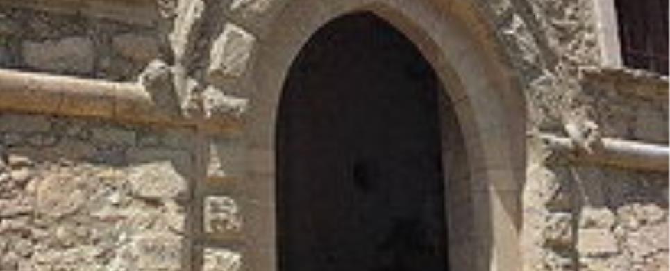
Doorframe of the residence at 13, Klidis Street: Doorframes often display
ornaments in the triangular space beside the semi-circular pediment, as is the
case in this building, where the interesting motif of naked children hunting birds
is depicted. In the crown of the doorframe with its Corinthian capitals the following
inscription can be seen: QUI SPERAT IN DEO SUBLEVABITUR (He who believes in God
will be comforted).
Doorframe of the residence at 48, Arkadiou Street: This is one of the most
impressive doorframes in the town of Rethymno displaying pilasters with Corinthian
capitals and columns with capitals influenced by the Gothic order. Both triangular
sides of the semi-circular lintel are ornamented with cupids. The relief of an
acanthus in the crown of the arch is also very impressive.
Doorframe of the residence at 30, Vernardou Street: This interesting doorframe
displays a Latin inscription dated 1607 as well as the coat of arms of the Clodio
family.
This text is cited Nov 2003 from the Tourism Promotion Committee of Rethymno Prefecture URL below, which contains images.
The Loggia, situated in the centre of the city, was a magnificent building, where the nobility met to discuss political and economic issues. It dates back to the 16th century and was built according to the plans of the famous Venetian architect Michele Sanmicheli. The well-preserved building has a square ground plan with three vaulted sides (the west side is not vaulted). It is built of regular sized stones and the projections of the cornice are particularly beautiful. Originally the building was open and had a four-sided roof, qualities which do not apply any more today.
This extract is cited Jan 2004 from the Tourism Promotion Committee of Rethymno Prefecture URL below, which contains image.
The sixteenth century Venetian Loggia on the corner has survived in almost perfect shape. The Loggia was an intricate part of Venetian social life providing space for both entertainment and business. Notice the two gargoyles with human faces on the west wall. Each of the three visible walls have three equal semi-circular arches with the middle arch providing an entrance at the ground level. The building is closed, as the city plans to renovate its interior.
This text is cited Nov 2002 from the Crete TOURnet URL below, which contains images.
Beside the church is the entrance to the Turkish primary school, which is still a primary school (Greek). The double arched doorway is a replica of the Fortezza entrance but with ornate relief of vines, lions, mosques and a crescent moon. The other door of the school (west side) has an inscription attesting to the girl's school founded there in 1796. In the north end of the school yard there is a Turkish grave, which is in very good condition, of a hero of the Battle of Rethimnon. Also the school yard has a good view of the Neratze Mosque and its minaret.
This text is cited Jan 2004 from the Crete TOURnet URL below, which contains image.
STERNES (Village) AKROTIRI
In Sternes there is a large Venetian structure as well as remains
of Venetian houses.
THERISSO (Village) CHANIA
The Eleftherios Venizelos Centre for Independence is in Therisos.
In 1905, Venizelos, the revered Cretan politician, set up a revolutionary assembly
here demanding immediate union with mainland Greece. As a result of this assembly
and the ensuing riots, Prince George, the High Commissioner of Crete, resigned.
Finally, in 1913, Venizelos's dream of union with Greece was realised. The house
(his mother's) is to the left in the middle of the village, and has been preserved,
but no official status is given to it.
This text is cited Oct 2002 from the Crete TOURnet URL below, which contains images.
ETIA (Settlement) LASSITHI
Tel: +30 28430 23917
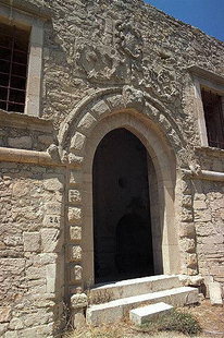
Etia is situated between the Papagiannades and Armenoi villages. Doubtless the name "Etia" comes from the namesake tree (Itia in Greek means willow). Though the settlement already existed in the Byzantine period - as the Byzantine churches of St. John and St. Catherine indicate - it flourished at the time of the Venetian occupation in Crete (1204-1669), as a fiefdom of the Venetian family De Mezzo. The jewel of their estate is villa De Mezzo, which is considered among the most characteristic examples of the Venetian urban architecture in Crete. In the following years of the Ottoman occupation, it was used as the residence of the Turkish officials, and therefore named by the locals "Seragio-Saray".
The first to mention that the villa of Etia was built by a rich and noble Venetian was the English Admiral T. B. Spratt, whose comments on his travels in Crete remain a valuable historical source from the mid-19th century. Later, the Italian archaeologist G. Gerola, links the owner of the villa with the members of the De Mezzo family. According to the genealogical records of the Venetian gentry there were three Mezzi in Sitia, Pietro, Nicholas and Giacobbe. Among them, Pietro dei Mezzo is considered to be the founder of the Etia estate and the owner of its villa towards the end of the 15th century.
The very emblem of De Mezzo, consisting of exotic figures bearing a broad shield, stands over the imposing entrance of the main megaron. By passing the entrance of the three-storey building, the visitor enters a barrel-vaulted antechamber with paved floor. Opposite the entrance, a staircase leads to the second floor. Here, on the lintel of the entrance to the floors, around a relief head, runs the following inscription in capital Latin letters:
VIZARI (Village) RETHYMNO
In Vizari, near the centre of the village, there are also the remains
of the Palazzo dei Saonazzi and its sundial.
AGII DEKA (Village) HERAKLIO
The church of Agii Deka presents many similarities with the church
of the Panagia Paliani, but it is not clear if it is of the first or the second
Byzantine period. It is a three-aisled basilica and the aisles are separated from
each other with five arches supported by three marble columns without bases. The
bases of the columns, simply decorated, seem to have been used as column capitals.
The floor is of white marble slabs enclosed in dark marble frames. The church
has an old narthex also subdivided into three parts and the exterior walls of
the church have blind arches.
This text is cited Feb 2003 from the Crete TOURnet URL below, which contains images.
GORTYS (Ancient city) HERAKLIO
The Early Byzantine church of Agios Titos is one of the most important
churches in Crete. It was originally a three-aisled basilica, but its architecture
was influenced by the sixth century trends of cruciform architecture developed
in Byzantium. A transverse aisle in the middle gives it a cruciform shape. At
the ends of this aisle there are conches (domed roof of the apse). There was a
dome in the middle, and the church had a narthex in the front. The nave and the
arms of the cross are barrel-vaulted and the back of the church has three conches.
This text is cited Dec 2002 from the Crete TOURnet URL below, which contains images.
KALOGEROS (Village) SYVRITO
Near the village of Kalogeros is the Byzantine church of Agia Marina.
Not visible from a distance and rather difficult to find, the church, located
near a hermit's cave, contains frescoes from the fourteenth century.
MARGARITES (Village) GEROPOTAMOS
There are also some fine examples of Byzantine churches in Margarites:
The church of Agios Ioannis Theologos has frescoes from 1383.
MONASTIRAKI (Village) RETHYMNO
The Byzantine church of Michael Archangelos is on a small square in
the village. It has an elegantly carved front door and pleasant decorations on
the windows. There is only one fresco in this church, that of the Assumption of
the Virgin, but it is of very good quality. The bell of the church has drawings
of Michael Archangelos and the date 1601 on it.
This text is cited Dec 2002 from the Crete TOURnet URL below, which contains images.
VIZARI (Village) RETHYMNO
Tel: +30 28210 56119, 53033
Fax: +30 28210 56118
AGIA ROUMELI (Village) SFAKIA
On the west side of the south end of Samaria Gorge, on top of a hill,
are the remains of a Turkish castle.
AGIOS VASSILIOS (Village) NIKOS KAZANTZAKIS
CHANIA (Town) CRETE
The fort still known with its Turkish name, Firca (Firka = barracks) was built in order to protect the entrance of the harbour. A thick chain from Firca to the base of the light-house closed the harbour in case of siege. The fort was the headquarters of the Military Commander of the city. The inside area was divided into barracks and ammunition warehouses. The buildings of the west wing have two-floors with dome covered rooms. Over the door of the first floor there is the following inscription : "ALOYSIUS BRAGADEUS PROVISOR CYDONIAE M. DCXX". In the centre of the court, there is a large water reservoir, where the water running from the roofs was collected. In the period of the Turkish occupation and until fairly recently, Firca was used as military barracks and a prison. The flag of the Unification of Crete to Greece was symbolically raised on the corner watch-tower on 1st December 1913.
This text is cited Sep 2002 from the Municipality of Chania URL below, which contains images.
The Firkas Bastion is at the western end of the outer harbour. It now houses the Naval Museum. The Venetians used it as a prison for Greeks condemned to death. Eleftherios Venizelos and King Constantine officially raised the Greek flag here in 1913. During the summer months, the Firkas is host to a local Cretan dance group that gives public performances. Plays and concerts are also performed here.
This text is cited Nov 2002 from the Crete TOURnet URL below, which contains images.
CHARAKAS (Village) ASTEROUSSIOI
In the village of Harakas there are remains of a Venetian castle on
a 35-metre hill. From the castle there is a wonderful view of the Mesara Plain.
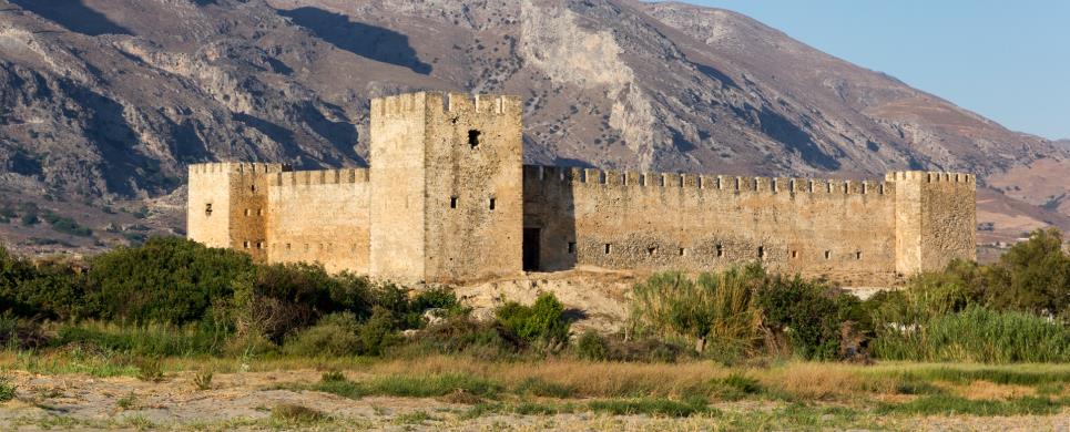
FRANGOKASTELLO (Castle) SFAKIA
Tel: +30 28210 56119, 53033
Fax: +30 28210 56118
The Venetian fortress
was erected by the rulers of the island in 1371, in order to protect the small bay from the pirates. However it was barely used for
defensive purposes during the Venetian era and on the eve of the Turkish attack, it was actually abandoned. In 1828 the Cretan
rebels occupied the fortress and during the siege that followed, its towers were destroyed.
The fortified castle is a typical example of the Venetian defence architecture with a rectangular shape with
towers on each side.
Over the gate, one sees a relief with the Lion of St Marcus and the Venetian crowns. The buildings in the interior, as well as the
battlements, were constructed during the ottoman occupation; at the same time many repairs were carried out. Underneath the fortress,
there are the ruins of the church of St Marcus.
According to tradition, during the second half of May and with a specific weather, shadows of the armed cretan warriors,
who lost their lives there, seem to march towards the fortress. The locals call them "Drosoulites". Near the fortress, is the church of
St Niketas of 1371, where there are traces of an Early Christian basilica. The works of restoration and consolidation were carried out by
the 13th Ephorate οf Byzantine Antiquities.
The exterior of the Venetian fortress (1371) has survived in excellent condition although the interior is in ruins. It has a square design with a tower at each corner. Above the gate is the emblem of Venice, the lion of St. Mark. The Venetians built the castle to deter pirate raids and to bring some order to this area. The castle is associated with some fierce battles. In 1828, a small band of Greeks, headed by Hatzi Michali Daliani, occupied the castle in an attempt to spread the War of Independence to Crete. He and his small band of rebels were massacred by the much larger Turkish force on the plain of Frangokastello. Their martyrdom became the subject of heroic legends and songs. The local legend says that on or around the anniversary of this battle (17 May), you can see the ghosts of Daliani and his army. They appear in the early morning, marching from the castle. These spirits are called "dhrosoulites" or "dew shadows" by the locals.
This text is cited Nov 2002 from the Crete TOURnet URL below, which contains images.
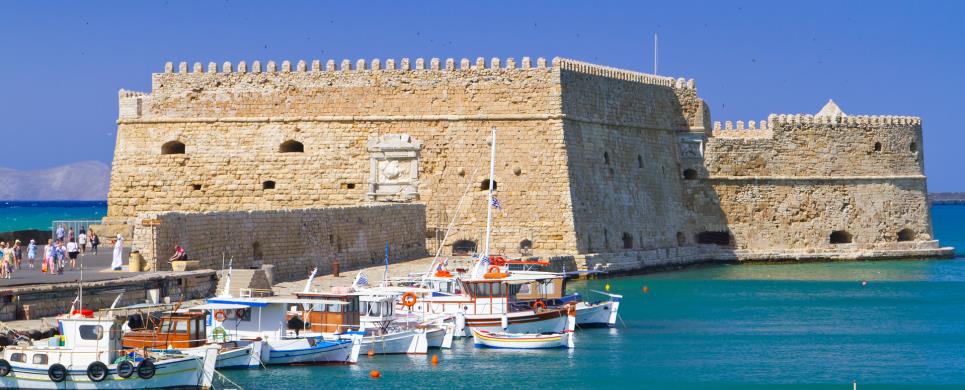
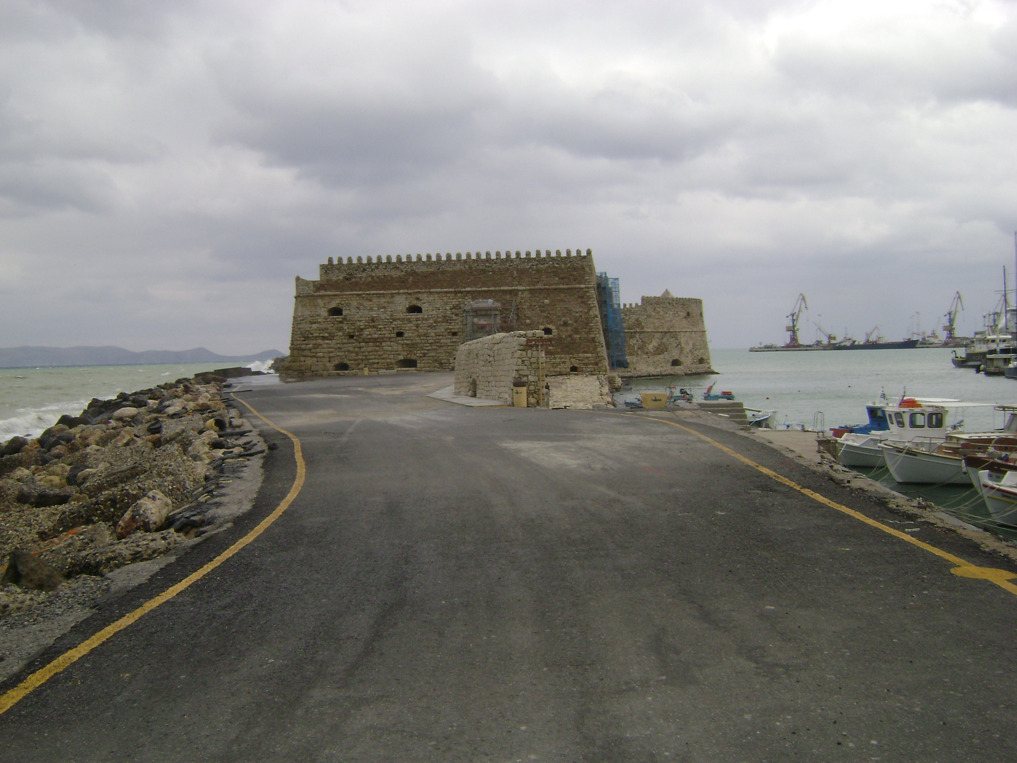
HERAKLIO (Town) CRETE
Tel: +30 2810 288394, 288484, 399206, 399266
Fax: +30 2810 288484
The original name of the
fortress
was «Roca al mare»; it was built by the Venetians, before the construction of the new walls. It was destroyed by the great
earthquake of 1303 and took its final shape between 1523 and 1540. During the ottoman occupation, it served as a prison,
in whose dungeons perished many revolutionists.
A typical example of the Venetian defensive architecture,
the fortress was built for the protection of the harbour breakwater
and consists the termination of the city walls.
The building comprises massive walls and two floors.
The ground floor has a vaulted roof with large skylights.
Thick walls divide the entire place in 26 lodgings, used as the residences of the Castellan, the captains and the officials, as well as warehouses.
The superstructure and the minaret
- from the latter only the base is preserved today - are additions of the Ottoman era.
Today the monument attracts many visitors and is among the most well known archaeological sites of Crete.
It also houses cultural events and exhibitions, while a small theatre has been fromed in the second floor.
A Venetian seaside fortress situated at the entrance of the old harbour. It was built by the Venetians, before the construction of the new Venetian fortification, in order to protect the pier and the port. It took its last shape in the years between 1523 - 1540 replacing another construction destroyed by an earthquake. It has been continuously repaired due to the violent waves of the sea that always used to cause damages to its stonework and foundation. It was built with big blocks of stone and it consisted of two floors. On the ground floor there exist 26 rooms that were used to house captains or to store food and ammunition. On the upper floor there are battlements for placing canons. The upper parts of the castle and the existing base of the minaret are Turkish changes. On the outside of the main sides of the castle, there are relief plaques that stand out with the lion of St. Mark, the symbol of Venice. During the Turkish period in the dark and humid rooms of the castle, the Turks used to torture and imprison the Cretan revolutionaries. Today, the castle is open to visitors and during the summer period it is used for various cultural activities (art exhibitions, music, theatre).
This text is cited Jan 2003 from the Municipality of Heraklion URL below, which contains image.
IERAPETRA (Town) LASSITHI
The Venetians built the fortress and harbour and in 1626, they enlarged and reinforced it. Recently, the castle was restored by the city.
IMERI GRAMVOUSSA (Island) CHANIA
KISSAMOS (Town) CHANIA
The name Kastelli came from the Venetian castle that was in the town
but the town's formal name is Kissamos. The bombing of World War II mostly destroyed
the castle.
This text is cited Oct 2002 from the Crete TOURnet URL below, which contains images.
KYRIAKOSELIA (Settlement) ARMENI
In the village of Kastelli, at the top of the valley, you may walk
to the summit of the hill (15 min.), to see the Byzantine fort of Kyriakoselia.
Inside the walls behind the new church there are reservoirs and wells and the
remains of the original Byzantine church of Agia Paraskevi.
MONOPARI (Settlement) NIKIFOROS FOKAS
After the 4th Crusade Crete was turned over to Bonifatius of Montferrat, who at a later date sold the island to the Venetians. However, in 1206 the Genovese pirate Enrico Pescatore conquered and besieged the island, and only as late as 1210 did the Venetians succeed in recapturing it. One of the fortresses built by Pescatore is the Fortress of Monopari (Bonripario), remnants of which can be seen from the top of the precipitous hill of Kastellos near the village Ano Valsamonero. Being already a natural stronghold the site merely demanded the construction of a wall at the north side of the hill, which provided the only access. Although the fort has not been restored, one can clearly distinguish two rows of walls at the north side, including three towers for the protection of the entrance, as well as the remains of buildings, two of which were probably storerooms, a cistern and a well.
This text is cited Febr 2004 from the Tourism Promotion Committee of Rethymno Prefecture URL below, which contains image.
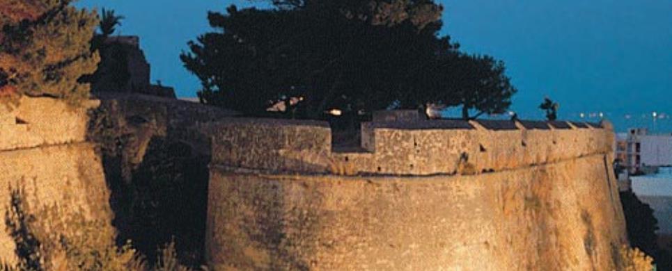
PALEOCHORA (Small town) CHANIA
In Paleohora, the Venetians built a fortress in 1282 and called it
Castle Selino, the name of the district today. The pirate Barbarosa destroyed
the fort in a raid in 1539 but the outside of the fort is still well-preserved.
This text is cited Oct 2002 from the Crete TOURnet URL below, which contains image.
At this location many Venetian maps present the Fort called Selino - Kasteli. The fort was built in 1280-82 and for its favor all the country was renamed from "Orina" to "Selino". The fort was destroyed by the Romans of the Crete in 1332. It was rebuilt in 1334 by the Venetians and under the Fort they founded a new settlement for workers and merchants, that took the name Vourgos. The pirate Barbarosa destroyed the fort in 1539, but later in 1595 Dolf revamped it.
This text is cited Jan 2004 from the Interdynamic S.A. URL below, which contains image
PROFITIS ELIAS (Small town) HERAKLIO
In the area there are visible remains of the Byzantine fort as it
was repaired by the Venetians. The remainders of five churches are also visible,
some of them dating from the era of Nikiforos Fokas. The fort itself (Roka) is
on the west peak of the hill which was the acropolis of ancient Lycastos. The
fortifications are visible from a distance as you approach the village of Profitis
Ilias and they can be reached by car and a short walk to enter the area within
the walls. In the upper castle (east side) are the remainders of the church of
Agios Nikolaos and two cisterns. Between the two hills on the north side are the
remains of Agia Paraskevi and fortifications. On the west hill are the remainders
of the Panagia, which has a north-south orientation, a double cistern, a large
fountain, and the church of Agios Antonios which was a military barracks during
the Venetian era.
This text is cited Feb 2003 from the Crete TOURnet URL below, which contains images.
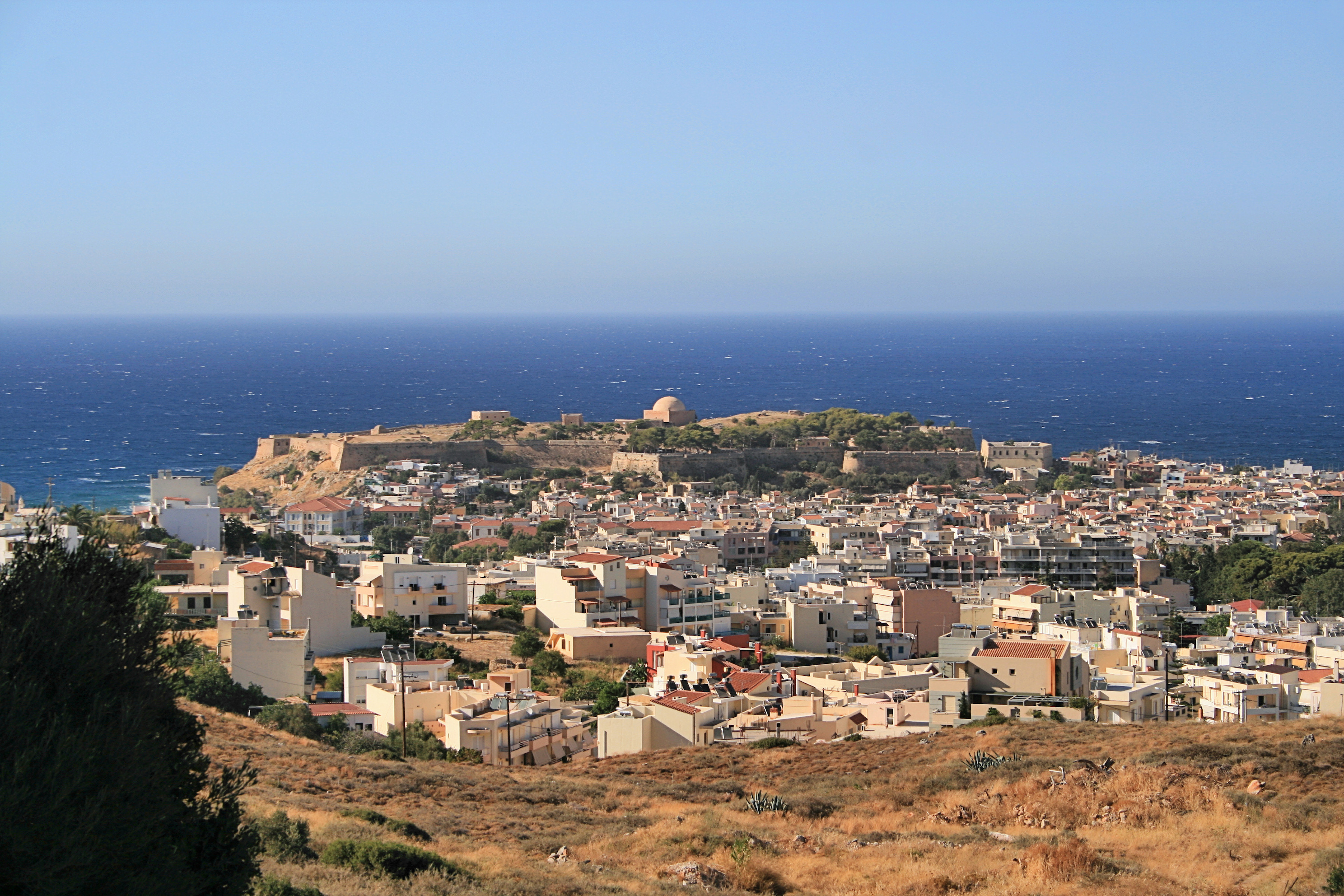
RETHYMNON (Town) CRETE
Tel: +30 28310 40150-6, 23653, 58842
Fax: +30 28310 40159, 58843
The fortress of Rethymnon
was built between 1573 and 1580 by the Venetians, for the protection of the city by the Turkish threat.
It is starshaped
with three gates and six bastions. The fortress enclosed the Commander' s house, the Counsellor' s house,
barracks, stables, ammunition - storehouses, a cistern and private houses which were later destroyed.
There was no systematic excavation on the site. Small-scale excavations have been conducted during
the restoration works, in the course of which came to light remains of the ancient city.
Some years earlier, the 13th Ephorate of Byzantine Antiquities effectuated
works of restoration and consolidation. The architect D. Pikiones had completed a study concerning a
new project of the fortezza: a theatre for representations of the medieval cretan plays, tourist accomodations etc.
Today the Municipality of Rethymnon in collaboration with the competent services, suggests a restoration
study which will bring the monument to its full advantage.
The most important monuments and architectural complexes are:
The Counsellors' residence.
It is formed of a ground floor and a first floor with large rooms. It was an imposing building, and served
during the ottoman occupation, as an official residence. The Italian Remaissance palaces served probably
as the model for its construction.
The Rector' s residence.
It was an imposing complex. Today in ruins.
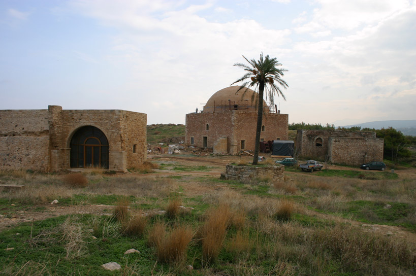
The Cathedral.
It was founded in 1583 and dedicated to St Nicolas. During the Ottoman occupation it was turned into a mosque
of Sultan Ibrahim. It is a large square room with a cupola. The only remnants of it are the minaret' s base and the
mihrab.
Gunpownder-shorehouses.
Inside the fortress there are two gunpowder-storehouses: They are rectangular buildings with vault and air-locks.
The walls are thick with small doors and extra rooms for better safety.
Ammunition-storehouse.
The ground floor and the first floor are covered with vaults. Over the entrance of the ground floor there is an arched
lintel. Three pillars supported the wooden floor of the first floor, where several parts of guns were stored.
Possible Bishop' s Mansion.
It is formed of two buildings: The larger, is a unified room covered with vaults, while the smaller is a latter addition.
It is considered as the Bishop' s Mansion because of the Cathedral near by.
The new fortification of the building complex included a magnificent
entrance gate, the Porta Guora, which led to the central square, where the superb
public buildings such as the Loggia, the Rimondi Fountain and the sundial tower
were situated. In 1571 Ulutz Ali devastated the wall during one of his raids.
Thus it became absolutely vital to fortify the hill of Palaiokastro (Old Castle)
and to relocate the entire city there. Many problems had to be solved before the
Fortezza was finally built during the period between 1573 and 1578. However, the
city was never transferred to the safe area within the walls.
Two years after the destruction, on September 1573, the Rector Alvise
Lando laid the foundation stone of the castle, which was to be built according
to the drafts of Sforza Palavicini. After a large number of modifications, the
fortress was finally completed in 1590. The general draft of the fortress provided
new forms of defence, which had become necessary, since gunpowder had come into
use: The polygonal ground plan included bastions whilst the walls were wider and
inclined. In reality however, due to the morphology of the land only three bastions
could be built to the South and to the East, while the north wall formed three
peaks. In general the draft of the fortification wall was not the best possible,
since it limited defensive abilities. The rocky surface, which impeded an appropriate
construction, the lack of a moat, the limited free space around the fortress resulting
from the inhabitants' refusal to demolish their houses were some of the basic
factors, which limited successful defensive action. Contrary to that the infrastructure
of the interior space was probably well planned: Public buildings were situated
at a distance from the wall, the ammunition storerooms were housed at the safe
north side, and a square formed the centre of the fortress. The interior of the
fortress accommodated the following basic buildings: the storeroom of the artillery,
where canons and weapons were kept, the residence of the Councillors, where one
of the city's two Venetian councillors lived, the residence of the Rector, which
represented a luxurious, magnificent building in the central square of the fortress.
West of the central square and opposite the cathedral the Rector's
residential premises were built, part of which have been preserved up to today.
The building was founded in 1575 and completed in 1582, and it was first occupied
by the Rector Anzolo Barocci. He continued to modify the building up until 1584,
because he considered it to be too high and exposed on the hill of Aghios Athanassios,
in the west of the city. The imposing and luxurious style of the building is testified
to in written records of that time referring to 49 doors, 81 windows, two staircases
as well as galleries. Unfortunately, none of the buildings of this complex could
be preserved, except for part of the prison, which Barocci had built east of the
main residence, and for the cathedral, which was situated opposite the remarkable
residential complex of buildings and was dedicated to Aghios Nikolaos. The temple
of Sultan Ibrahim was built on the ruins of the cathedral of San Nicolo during
the Turkish occupation. New elements such as the large semi-circular dome, the
apse of Michrab in the centre of the southeastern side as well as the minaret,
which was built next to the entrance, characterised the transformation of the
cathedral into a Muslim temple.
This text is cited Jan 2004 from the Tourism Promotion Committee of Rethymno Prefecture URL below, which contains images.
The giant Fortezza dominates Rethimnon, and is reputed to be the largest
Venetian castle ever built. Designed to shelter the entire population, it included
a church, barracks, a hospital, and storerooms.
The Venetians built the Fortezza
during a transitional period in military history. In the fifteenth century, armies
began using gunpowder in military activities and this prompted the designing of
forts which could withstand this type of attack. The Venetians in Rethimnon did
not have adequate funds to complete the Fortezza according to the new formula
for defensive structures. They allowed the houses of the town to remain close
to the walls, leaving no distancing space or room for a moat. This, as well as
other factors, including a cholera epidemic in the fort, led to a rather easy
victory for the Turkish invaders in 1645.
Sites of the Fortress:
Main Gate: The
main gate is between
the Agios Pavlos
and the Agios Nikolaos
Bastions that were its protectors. The gate is a tunnel going through the walls,
wide and high enough to allow for movement of troops, wagons and artillery.
Artillery Magazine:
The Artillery Magazine
is the first building on your right as you enter the Fortezza. The bottom floor
was used to store the cannons while small arms were kept on the second floor.
The flat roofs of the buildings collected rainwater which was then piped to the
cisterns. Evidence of the aqueduct system can be seen on the Artillery Magazine.
Cisterns: There
were many cisterns in the fort. The flat roofs gathered the water and pipes conducted
it to the cisterns. One of the better examples of this is in the Agios Ilias Bastion.
It is on the southeast point of the fort, to the left of the artillery magazine
(near the open air theatre). This chamber is open and is one of the fort's more
interesting sights.
Bishop's Palace:
There is some question as to whether this actually was the bishop's
quarters, since what remains
does not resemble any description of the bishop's palace.
Ibrahim Han Mosque:
After a Turkish attack destroyed the cathedral of the city, the Venetians decided
to build the new one inside the Fortezza. The Turks converted it to a mosque
after they captured Rethimnon and named it after their sultan. The mihrab (prayer
niche that points to Mecca) is on the east wall.
Governor's Residence:
The original building
was very large, but very little of it has survived.
Powder Magazines:
Two of three magazines
remain. They were located in remote places in the fort. The very thick walls were
constructed to withstand cannonball fire and with ventilation holes to keep the
powder dry.
Councillor's Residence:
This is where one of the two counsellors
lived. Their job was to control the residents of Rethimnon. Evidence of a Turkish
bath is in the upper northwest corner.
Storerooms: The
Venetians put the storerooms
at the northern wall to be safer from attack. There were underground storage rooms
as well as a level above ground. Notice the ventilation holes in the walls. The
passage to the
gate lies in the middle of these rooms.
Unidentified Buildings:
Archaeologist know little about these buildings.
The cement trench on the east side dates from World War II and led into a holding
room for Cretan resistance fighters whom the Nazis eventually executed.
Civilian Living Quarters:
The occupants of these buildings
were poor and construction was therefore not strong, so, little remains of the
houses.
This text is cited Nov 2002 from the Crete TOURnet URL below, which contains images.
SITIA (Town) LASSITHI
There were fortifying walls around the city of Sitia from the Byzantine
period. These fortifications were restored by the Genoese and by the Venetians
but were never very strong. In 1539, the pirate Barbarosa conquered the city and
levelled the forts and the town. When the Turks invaded the island the Venetians
destroyed the fort so that it would not fall into the hands of Turks. The ruins
of a Venetian castle are still visible today. A tower of three storeys has survived.
North of the fort there is a little chapel built from the ruins of a Venetian
monastery destroyed by the Turks.
This text is cited Mar 2003 from the Crete TOURnet URL below, which contains images.
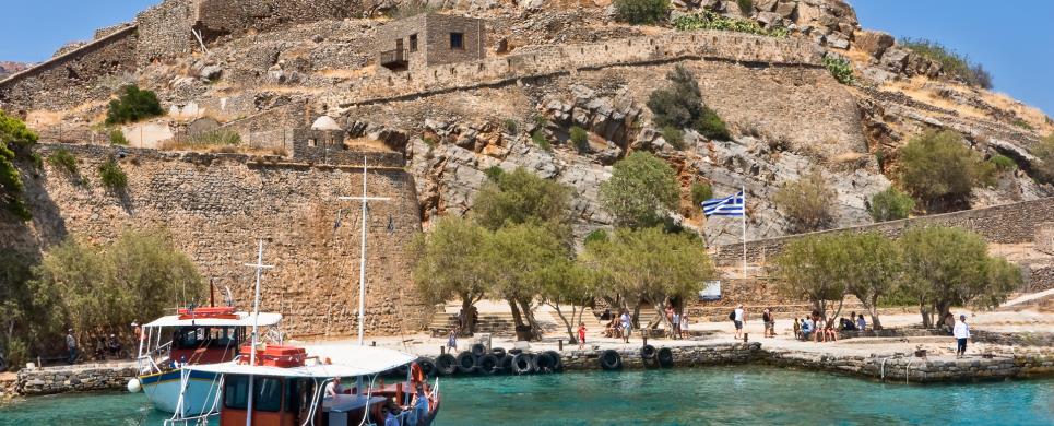
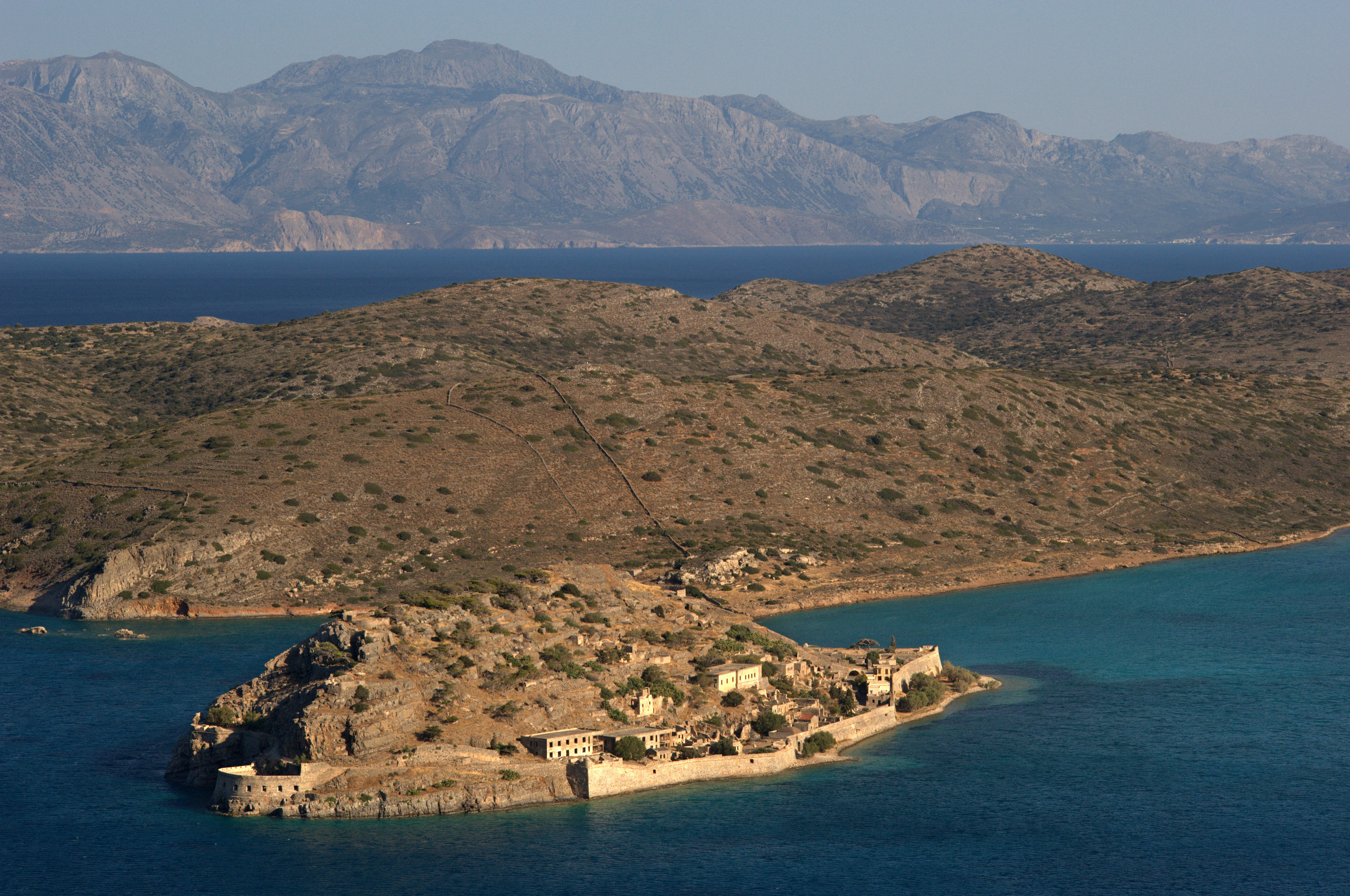
SPINALONGA (Island) CRETE
Tel: +30 28410 41773
The
islet of Spinalonga
is located at the entrance of the Elounta bay.
In antiquity there was a fortress of the Olounites. In 1579 the Venetians built an imposing
fortress
and the islet was used as a military camp during the Venetian - Ottoman wars which ended with the subjection of Crete to the Turks in 1669.
It is noteworthy that the fortified Spinalonga was occupied by the Ottomans only in the early 18th century and was used as
a settlement until the end of the 19th centrury. From 1903 until 1957, by law of the Cretan and later the Greek State,
Spinalonga was established as a settlement for the lepers.
ARKOUDOSPILIA (Cave) AKROTIRI
The cave of Our Lady of the Bear (Spileo Arkoudas) is on the path
from Gouverneto to Katholiko. The chapel dedicated to the Virgin is inside the
cave. At the rear of the cave there is a grey bear-shaped stalagmite with a small
pond in front of it. Local legend says that the Virgin Mary turned the bear to
stone after she caught it drinking the monks' water. Archaeologist claim that
in antiquity the cave was a shrine to Artemis, who was transformed into the shape
of a bear. On the first day of February local people come in the evening for the
church service and stay in the cave afterwards to celebrate with food and wine.
This text is cited Oct 2002 from the Crete TOURnet URL below.
AVRAKODES (Village) OROPEDIO LASSITHIOU
South of the village
GERANI (Port) NIKIFOROS FOKAS
The Gerani cave displays magnificent stalagmites and boasts 6 halls. Apart from three human skeletons archaeological research has brought to light a variety of bone and stone tools dating back to the Neolithic period. Furthermore important material of palaeontological interest was found, probably relics of more than 100 endemic deer, which must have died towards the end of the Pleistocene period. The human skeletons belonged to people who were probably trapped in the cave, perhaps due to an earthquake.
IDI (Mountain) RETHYMNO
The Ideon Andron is situated on the Nida plateau of Mount Psiloritis, 24 km from the village of Anoghia and 78 km from the town of Rethymno. Initially its extraordinary large entrance impresses visitors to the Ideon Andron, which is at a height of 1538 m. The cave itself is of particularly large dimensions, with a vast central hall and a gallery of 22 m in length. The cave, in which Zeus was raised according to mythology, represented an important place of worship in both the Minoan and the Roman period. The excavation works that were carried out in the interior of the cave revealed an abundance of important finds such as ceramics, gold jewellery, metal objects and of course the famous bronze shields. Since research is still in progress the cave cannot be visited.
KAMARES (Village) TYMBAKI
The Kamares Cave contained a very distinct form of pottery, "Kamares",
dating back to 2000 B.C.; it is now on display in the Iraklion Museum. You can
walk to the cave in 4 hours on a difficult path that is not well-marked. From
Kamares you can reach the peak of Psiloritis. This is only recommended for experienced
hikers.
This text is cited Dec 2002 from the Crete TOURnet URL below, which contains images.
KERATOKAMBOS (Settlement) VIANNO

Receive our daily Newsletter with all the latest updates on the Greek Travel industry.
Subscribe now!


