Listed 100 (total found 119) sub titles with search on: Main pages for wider area of: "EVIA Island GREECE" .
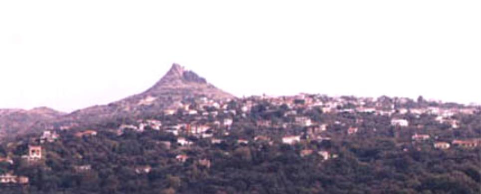
AGDINES (Village) ISTIEA
It is a village built in a thick forest of pine trees on a mountain.
The drive from the main cross-roads to the village is enjoyable even to the most
demanding visitor. Perennial plane trees, pine trees, flowing streams and the
Aegean Sea, which lies in
the background, leave the visitor speechless with astonishment. The region is
ideal for the fans of hiking.
Τhis text is cited May 2003 from the Municipality
of Artemissio tourist pamphlet.
AGIANNAKOS (Settlement) CHALKIDA
A small agricultural colony, in about 5 km southerly of Rovies.
Its name is derived from the old church of Saint John (we find it in the 17th
century). Traces of ancient activities are found in this area.
This text is cited May 2003 from the Municipality of Elymnies tourist
pamphlet.
AGIOS GEORGIOS (Village) KARYSTIA
Tel: +30 22230 31054
AGIOS NIKOLAOS (Village) CHALKIDA
Tel: +30 22210 52326
The picturesque beach of Bourtzi got its name from the large fortress, built by the Venetians and used also by the Turks to control the straits of the Southern Evian Gulf, so that pirates could pass to and from Chalkida. The beach is not as popular for swimming as are the taverns which will give you a taste of fresh Evian, fish.
AGIOS VLASSIOS (Village) KARYSTIA
Tel: +30 22220 58603
AGRIOVOTANO (Village) ISTIEA
According to tradition its name stems from the weeds ("agriovotana")
growing in the region. Even though it covers a small area, it offers a spectacular
view. From the small square of the village the visitor can discern the mountain
Pilio and, weather permitting, even Athos. A passable dirt road leads from the
village to the beach "Koutsoubri" where there are picturesque taverns. The beach
is ideal for windsurfing and jet-skiing. The luxuriant vegetation and the long
beach compose a unique colourful scenery.
Τhis text is cited May 2003 from the Municipality
of Artemissio tourist pamphlet.
ALMYROPOTAMOS (Village) EVIA
Tel: +30 22230 53012
Fax: +30 22230 53816
Almyropotamos is the most notherly village of the Municipality
of Styra, located close to the border with the Municipality
of Dystos in an area of great interest. It has 500 residents and is set in
a rocky hillside in front of the valley which spreads out from the Dipotamo river.
The coastal hamlet of Panagia
belongs administratively to Almyropotamos, as does the islet of Kavalliani.
Many commentators identify Kavalliani as the ancient Glaukonissos, in the soil
of which the Olympic winner Glaukos, son of Dimilos, was buried by his fellow
Karystians.
The palaeontological survey in the valley of Almyropotamos has uncovered
many important finds which belong to mammals of the so-called Picermius fauna.
These are mainly the remains of small-bodied horses which were no higher than
1.30 metres tall and had three toes on each foot. According to specialists, Picermius
fauna belongs to a steppe environment and has an Asian origin; it is dated to
around 13 million years ago.
This text is cited May 2003 from the Municipality
of Styra tourist pamphlet.
AMARYNTHOS (Small town) CHALKIDA
ANO KOUROUNI (Village) KARYSTIA
Tel: +30 22220 58969
ANO POTAMIA (Village) KYMI
Tel: +30 22220 71498
ANO VATHIA (Village) CHALKIDA
Tel: +30 22290 36680
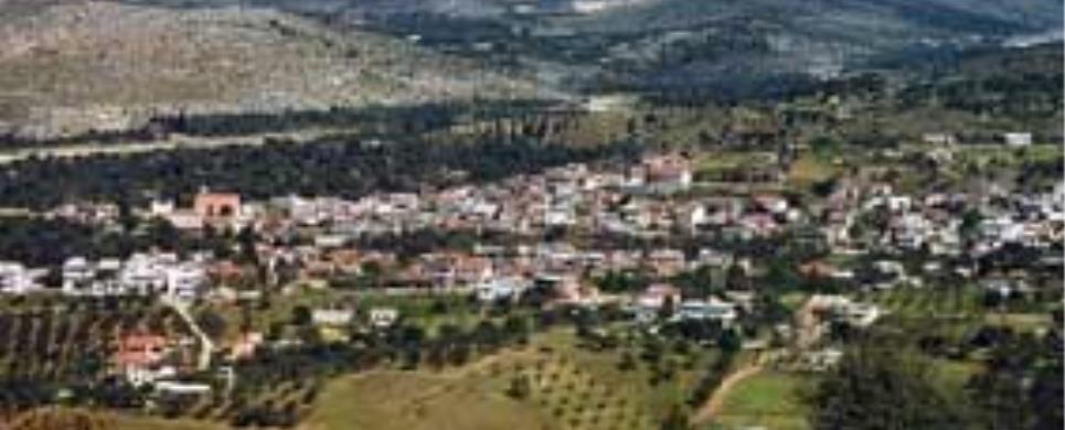
ARTEMISSIO (Village) ISTIEA
Artemissio is the main village in the Municipality of Artemissio.
The old name of the village was "Kourbatsi" (Turkish word which means thrashing).
In 1926 the village established a community independent of the Municipality of
Istiaia and was renamed Artemissio
in honour of the goddess Artemis whose temple was situated in the area of St.
George, where the cemetery of Pefki
is located today.
A tour of the village, where there are still houses dated from the
Turkish domination, is worthwhile. If you are fond of nature, you will enjoy walking
a little further from the village where there is a magnificent ravine full of
plane -, pine- and walnut-trees which will lead you to an area called "Agrilitsa".
The view is breathtaking, the eye can see as far as Mt Pelion
and the Sporades.
Τhis text is cited May 2003 from the Municipality
of Artemissio tourist pamphlet.
ASMINIO (Village) ISTIEA
Tel: +30 22260 41309
A modern village which maintains local colour. Its former name was
Potaki or Potoki (a word of Turkish origin) which means swampy area. It offers
comfortable accommodation and it is known for its nice ouzeris situated at the
central square. The village produces salted preserves of excellent quality.
It is worth visiting the church of Virgin Mary Dinious, 6km from the
village on the way to Istiaia, built in a magnificent landscape of plane trees
and flowing streams. The word "Dinious" is Turkish and means "return". According
to tradition, when a Turkish soldier fired the icon of Virgin Mary, the bullet
backfired and killed him. Her memory is celebrated on August 23 at a big fete
which attracts many natives as well as tourists.
Τhis text is cited May 2003 from the Municipality
of Artemissio tourist pamphlet.
AVLIDA BEACH (Small town) AVLIDA
Tel: +30 22210 31334
A coastal area in the South Evian Gulf with a 6km shore line. The waters are shallow and there are many taverns along the beach with local delicacies. The beach of Avlida is connected by coastal road to Dilesi, Chalkoutsi, Skala Oropou and, via Vathy, to the national highway Athens – Chalkida. Until 1927 the area was called Dramesi but since then it was recognized as the municipality of Avlida belonging to Evia Island, even though it is on the mainland. The story of the village starts in the prehistoric era, according to a few findings in the area. A local myth is that residents are decendents of Kadmos from Sparta. It was also a tourist resort in antiquity for the people of Thebes as it is now for the Athenians. In the 1991 census Paralia Avlidas had 2.473 residents but the population rises dramatically in the summer due to vacationers and can reach up to 15.000.Paralia Avlidas is a scenic place that has evolved into a resort with many vacation homes. Being close to Thebes that has an army training center, many of its residents are high ranking officers and the locals are mainly involved in agriculture and fishing.
CHALKIS (Ancient city) EVIA
Chalkida, the historic capital of Evia, is of particular archaeological
interest. It was flourishing during the classical and Hellenistic periods. However,
the archaeological finds, as well as written evidence, confirm that the town had
been inhabited much earlier and was already flourishing in the Early Geometrical
period (1100-750 B.C.) trading with the West and East.
There are three explanations for the derivation of its name: firstly
it took its name from the copper mines, secondly from Chalkida, the daughter of
Asopos or thirdly from "Chalki" or "Kalki", the purple shellfish which the Phoenicians
used for a dye in the town.
Descriptions of ancient visitors and historians gives us a picture
of a large thickly-wooded city with one of the most important markets in Greece,
colonnades round the market place, many temples, beautiful public buildings, gymnasiums,
theatres, stately homes and fortified walls with tall towers. The town had two
harbours and a bridge with two towers at each end, over the channel
of Evripus. A fortified enceinte surrounded the town and a second larger one
surrounded Kanithos and Evripus.
There was also an important wall with towers round the acropolis of Chalkida which
was situated on the hill Vathrovouni, south of the modern town. The successive
destruction of the town by its various conquerors and the natural disasters which
it suffered over the centuries and the fact that the modern city is built on the
ruins of the ancient town are the reasons why the recent archaeological findings
don't reveal fully the beauty and greatness of ancient Chalkida.
This text (extract) is cited May 2003 from the Prefecture
of Evia tourist pamphlet (1997).
CHRONIA (Settlement) CHALKIDA
Coastal colony of about 100 inhabitants, fishermen and farmers, situated
just westerly of Limni, on
the road Limni-Edipsos.
This colony was formed by Minor Asian refuges, after 1922, who found
refuge to the area of Limni.
Chronia is a small - pleasant resort for anyone who wants to spend
there his summer vacations, attracting a number of tourists during the summer
period.
This text is cited May 2003 from the Municipality of Elymnies tourist
pamphlet.
DAMIA (Settlement) CHALKIDA
It is a village on an altimeter of 300 meters and over, at about 6
km distance southerly of Rovies.
The available signs from very old times (the Stone Age) for people lived in the
area and the name itself of Damia leading to very old times, are information needing
to be detected. The life in the village seems to be assimilated, during the old
times, to the life of a wider area of Orovies and in post-byzantium times, to
the life the dominating existence of the Convent of Holy David - the old man.
The residents today deal with agricultural and veterinary works and the people
according to the census in 1991 are 76.
This text is cited May 2003 from the Municipality of Elymnies tourist
pamphlet.
DRYMONA (Settlement) CHALKIDA
It is a mountainous village, situated at the northern "exit" of the
Convent of Holy David,
at an altimeter of 600 meters and over.
Drymona, the existence of which has been placed in the 16th century
and after, assimilated to the existence of the Convent of Old Man, is a nice fully
of forests village with a road leading to a little northern site where the waterfalls
of Sepia river, the most beautiful plateau the so called Microlivado (small meadow)
of Dry Mountain, and the
petrified forest of Kerassia
(district of Nilea Community).
The people living in Drymona are about 80, according to the recent
census of 1991.
This text is cited May 2003 from the Municipality of Elymnies tourist
pamphlet.
EDIPSOS (Small town) EVIA
Edipsos did not suddenly spring up yesterday. It is, on the contrary,
steeped in history, with deep roots in the distant past. Tradition holds that
the Iones first settled here and named their new home "Ellopia" for Ellopos, the
son of Iona. It was later referred to as "Edepsos" in Aristotle's Meteorologica,
a toponym also inscribed on a stone found in Thessaly. Ploutarch described a very
pleasant stay in Edipsos with its lively social life and entertainment, praising
its fine cuisine of fish and fowl. Strabon wrote of the appearance of new springs
and their healing properties. From very early times Edipsos was, moreover famed
for its copper mines, perhaps one for the reasons it was one of the few towns
to mint its own coins. One of them appears as an illustration in Regas Fereo's
Charta. It bears the image of a crab on one side and a fish on the other, symbolizing
the abundant sea life of the area.
In Roman times Edipsos flourished due to its mineral waters and the
favour it found amongst the Roman elite. The emperors Hadrian, Septimus Severus
and Marcus Aurilius bathed in its waters. Other visitors included Gaius Pompeius,
Savinus, procosul of the Emperor Augustus and General Syllas. The best preserved
ruins from the Roman period are known as Sylla's Baths.
With the decline in Roman domination and the rise in Byzantium, Edipsos
was destroyed for being a center of paganism.
In more recent times, the cosmopolitan atmosphere of Edipsos drew
the attention of renowned politicians, artists, writers and jet-setters.
This text is cited May 2003 from the Municipality
of Edipsos tourist pamphlet (1999).
ELLINIKA (Village) ISTIEA
The village is located on a slope of a hill covered with pine trees.
Its name has derived from the Greek ("ellinika") ships which anchored at the beach
before the naval battle of Artemissio.
Its beautiful beach is a real jewel, a harbour for small boats, with
pine trees along the sea. Across the beach there is a small island with the church
of St. Nikolaos. Swimming to the island is an opportunity to enjoy a workout.
Τhis text is cited May 2003 from the Municipality
of Artemissio tourist pamphlet.
ERETRIA (Municipality) CHALKIDA
Tel: +30 22293 50101
Fax: +30 22293 50150
ERETRIA (Ancient city) EVIA
Eretria is the second largest town in Evia
and was flourishing mainly during 800-700 B.C. and the classical period.
There are two possibilities for the derivation of its name: it may
come from the verb "ereso" which means "row" as the town had a strong navy, or
from the word arotro (plough) which became arotria and finally Eretria as the
inhabitants were landowners.
Many historians believe that the original location of Eretria was
on the hill of Xeropolis at Lefkandi
where archaeological remains have been found, until the end of the 8th century
B.C. when it was abandoned and transferred to the site of modern
Eretria.
This text (extract) is cited May 2003 from the Prefecture
of Evia tourist pamphlet (1997).
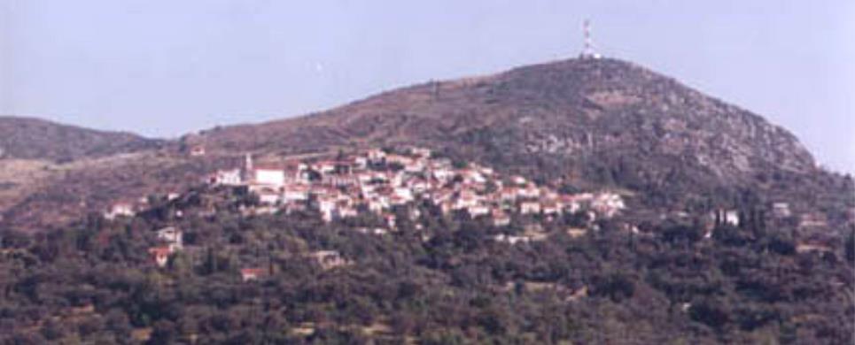
GERAKIOU (Village) ISTIEA
It is a village on a slope of a mountain situated only 4 km away from
Pefki in a thick forest of plane
and pine trees. Creeks pouring down in a waterfall at the entrance of the village
complete the scenery. The village was given its name due to the numerous nests
of falcons (the Greek word for falcon is "geraki") in the area. The people are
mainly engaged in the exploitation of forestal resources.
Τhis text is cited May 2003 from the Municipality
of Artemissio tourist pamphlet.
GOUVES (Village) EVIA
Tel: +30 22260 41435
A traditional village built on two mountain slopes full of plane and
pine trees. During the Turkish domination the region belonged to the Turkish bey
Mohamed Ibrahim and his sister Haime Naile. In 1831 the Turks sold their land
to the Greeks Vaptistis Drossos and Alexandros Desyllas. In 1882 the land of the
community was transferred to its inhabitants. The only highschool in the Municipality
of Artemissio is situated in the village.
A tower, where the Greek poet George Drossinis lived, rises above
the village. The tower has been restored to accommodate a museum. On the beach
of the village the fortress of Metaxas, which served as a defense post during
the World War II, still remains. You can see the base of the cannons, the cook-house
and the watch tower.
Τhis text is cited May 2003 from the Municipality
of Artemissio tourist pamphlet.
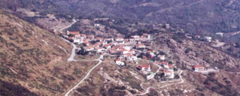
KALAMOUDI (Settlement) CHALKIDA
It is a mountainous village, situated at the "entrance" of the Convent
of Holy David.
Kalamoudi is surrounded by signs of life during very old times, nevertheless,
in particular, in Byzantine and medieval times, we find it "fully vivid" in blossom.
Since the 16th century its history has been identified the history
of the Convent of Old Man.
The people leaving in Kalamoudi are about 50, according to the recent
census of 1991.
This text is cited May 2003 from the Municipality of Elymnies tourist
pamphlet.
KALIMERIANI (Village) KYMI
Tel: +30 22220 23222
Fax: +30 22220 23222
KALOCHORI-PANTICHI (Village) AVLIDA
Tel: +30 22210 32945
KARYSTOS (Town) EVIA
The capital of southern Evia, Karystos, is built on the southern part of the island on a cove and in the shadow of mount Ochi. It is a modern town, developed for tourism. Karystos is approximately 120 km southeast from Chalkida but with a ferry connection to the eastern coasts of Attica.
The area has wonderful beaches and picturesque villages on mount Ochi, combining both sea and mountain. It can be the base for enticing tours to beaches or the mountain villages of Cavo D’Oro, in the Dimosari canyon.
The text was published on May 2003 in a brochure of Regional Division of Evia.
KASTANIOTISSA (Village) ISTIEA
KECHRIES (Village) CHALKIDA
Tel: +30 22270 92400
Kechries could be characterized as a junction connecting the eastern
with the western coasts of Evia, establishing, thus, ideal conditions for anyone
who wishes to spend his vacations there, combining the green forests of the village
with the freedom of choice among the coasts of Aegean or Evoic Seas.
Traditions and legends have combined the history of the small fountain,
found in the situation where the medieval village, so called Ligdia, and the passing
from there of the legendary knight, Erotocritos.
The area, which during the times of Turkish occupation was a Kara-Ali's
estate, was assigned, after the liberation, to the hands of the resolution fighter,
Angelos Tombazis. Then, after a decision of the Greek Government in 1925 it was
assigned to the landless farmers of the area.
Similar but at the same time, parallel to the history of Kechries,
is also the history of Daphne co-existing with the village of Kechries. It should
be noticed that in old times Daphne
was called "Mantanika" originated from the word "mantani" probably meaning the
high production.
This text is cited May 2003 from the Municipality
of Elymnies tourist pamphlet.
KONTODESPOTI (Village) CHALKIDA
Tel: +30 22280 91271
KOULOUROS (Settlement) CHALKIDA
Small agricultural and cattle-raising colony, situated near the road
Rovies-Istiaia
(through Voutas) and at a distance
of about 12 km northerly of Rovies, in fully green pine-trees forests bringing
in mind landscapes found in N. Europe. The geomorphology, the name, the surrounding
toponymies, ruins of old colonies and other historical signs, give proof of a
significant course of the village through the ages (specially in the middle ages).
This text is cited May 2003 from the Municipality of Elymnies tourist
pamphlet.
KOURKOULI (Village) CHALKIDA
Tel: +30 22270 92066
The village, so called Kourkouli, is a traditional mountainous colony.
It is situated at the 3rd km over the axis of the central road of Chalkida-Limni
and the foot of the mountain, so called "Dry
Mountain", in beautiful fully green with pine trees areas, on inclined plane
and altimeter of 400 meters.
It is of panoramic views, when one looks at the horizon of Aegean
Sea but also Evoic Bay.
The village was built by the residents of the colony, so called Skoulari,
which was situated at a distance of about 2 kilometers from the today's village
to the area of Drymona. Its residents
were forced to move because of brigands' and corsairs' invasions. The residents,
first, gave the village the name "Neo Skoulari". The Turks, however, changed its
name to "Kourkouli" meaning "pursued people". So, this name prevailed and has
been kept even until today.
This text is cited May 2003 from the Municipality
of Elymnies tourist pamphlet.
KYMI (Ancient city) EVIA
Kimi, which was one of the first towns, together with Chalkida
and Eretria, to establish
colonies in Italy, hasn't
been located with accuracy. It is believed that the significant ancient settlement
excavated at Oxilithos is
ancient Kimi.
This text (extract) is cited May 2003 from the Prefecture
of Evia tourist pamphlet (1997).
LIMNI (Small town) EVIA
Elymnion of the ancient people and Evoic Aeges. A coastal nice small
town with traditional elements in a soft creek of northern Evoic Bay, being situated
between Chalkida and Edipsos.
Looking back to mythology we find it in the prehistoric times at the
moment when Jupiter first joined Juno and during the historic times it became
a place of the gods' worship.
During the years of colonization it established its own colonies,
such as Kleones (and perhaps Elymnio) in the Chalkidiki
peninsula of Mount Athos.
In Roman, Byzantin and Francovenetian times its navigation flourished
again and it was attacked by various conquerors.
In the mid of the 16th century, immigrants from Aegean Sea arrive
in Elymnio, as in the same years, in a miraculous way, the ancient icon of The
Blessed Virgin Mary the "Lymnian" also arrives here, which came to become the
religious palladium of this place.
With the coincidence of both these events Castral Elymnio moves down
to the shore erecting there the today's town of Limni.
During the years of National Regeneration, it plays the leading part,
starting the Evoic Revolution.
In the years of liberation it forms a considerable commercial navy contributing to the whole case of the Greek Navigation.
In the years of the 2nd World War Occupation it plays again a leading
part, bringing forth famous figures of our Panhellenic National Resistance.
Today, it is a touristically developed town with signs of insular
traditional structure, with historical places and convents, rich folkloric tradition,
multiple natural beauty and summer cool winds, uninterruptedly caressing the tiled
roofs and...whistling its old tales...
This text is cited May 2003 from the Municipality
of Elymnies tourist pamphlet.
MAKRYCHORI (Village) KARYSTIA
Tel: +30 22220 81280
MAROULI (Settlement) CHALKIDA
Small agricultural and cattle-raising colony, situated near the road
Rovies-Istiaia
(through Voutas) and at a distance
of about 12 km northerly of Rovies, in fully green pine-trees forests bringing
in mind landscapes found in N. Europe. The geomorphology, the name, the surrounding
toponymies, ruins of old colonies and other historical signs, give proof of a
significant course of the village through the ages (specially in the middle ages).
This text is cited May 2003 from the Municipality of Elymnies tourist
pamphlet.
MESSOCHORIA (Village) KARYSTIA
Tel: +30 22240 53274
Messochoria, of the Municipality of Styra, took their name from one
of the villages. These villages, aside from Messochori
itself, are Riza, Souristra, the Charitides and Korfiotes, which is located on
the height. Along with the hamlets of Raptei
and Tsakei they have a population
of around 600.
The villages are located around 3.5 km from the Aegen
Sea and have two exits onto the discharges of the small dry streams, where
there are the bays of Almyriki (or Armyrorychi) and Limnionas. During the German
occupation, Greek and British members of the resistance escaped to the Middle
East from these bays and that at Tsakei. The bay of Limniona with its clean sand
has today developed into a summer resort.
There is a stone fountain with a vaulted arch at Kamara. This village
was known as Paleochori in Byzantine times. The hermitages of St. Dimitrios, St.
Nicholas and St. George, with a vaulted arch in the sanctuary, are still standing.
In the ravine there are the remains of a watermill which was built in 1890. A
trip to the ruins of the Monastery of the Evangelism of Tsakei, which today still
functions as a monastery due to the presence of one nun, is worth a visit.
This text is cited May 2003 from the Municipality
of Styra tourist pamphlet.
MONI AGIOU CHARALAMBOUS LEFKON (Monastery) AVLONA
Tel: +30 22230 34242
MONI AGIOU GEORGIOU (Monastery) EDIPSOS
Tel: +30 22260 24032, 60142, 22384
MONI AGIOU NIKOLAOU GALATAKI (Monastery) CHALKIDA
Tel: +30 22270 31489
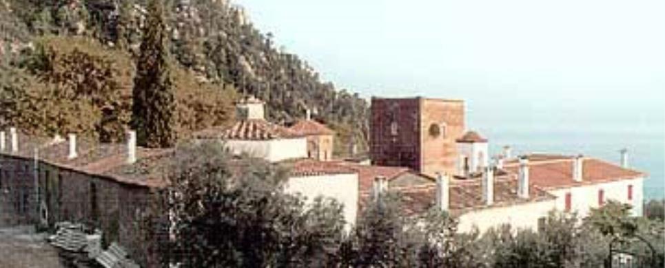
MONI OSSIOU DAVID GERONTOS (Monastery) CHALKIDA
Tel: +30 22270 71297, 71143
At about 12 km southerly of Rovies
and 21 km from the provincial capital of Limni
Community, there is the historical Convent of Holy David, the so called "Old
Man", built on the foot of Kavalaris Mountain (called in another way, Dry
Mountain) and an altimeter of 500 meters. The Convent was built in half of
the 16th century by Holy David himself, on the pre-existent ruins of the ancient
church of Christ's Transfiguration.
During the years of 1821 Revolution against the Turks, the Convent
supported actively the fight and assisted the Leader Captain Angelis Rovios, as
this results from the historic records kept in the Convent. This is the reason
that it was destroyed by Turks in 1823.
In 1877 it was reconstructed and so has continued its living till
today, in the form of a men's convent. Many chapels are built round the Convent,
with the Saint's cavernous hermitage located to the western point, "Agiokeri"
to the southern point, in sites of highest beauty.
In the underground chapel of the Convent's cells, in memory of Saints
Anargyroi, there are wonderful wall paintings of the 17th century.
Recently the figure of the deceased superior of the Convent enviable
father Jacob, was assimilated to the Convent, the world and the devoutness, and
the worshipers don't omit to pay a visit to his grave. The Convent, which was
restored today, welcomes a number of faithful throughout the year.
This text is cited May 2003 from the Municipality of Elymnies tourist
pamphlet.
MYRTIAS (Village) CHALKIDA
It is the "antechamber" of Limni.
A village with about 300 inhabitants, a little southerly of the coming-in public
road Chalkida - Limni, at Limni,
a nice fully green area, at the southern of the overlooking mountain, so called
Messopetrio. In this area, which had been inhabited since the ancient times, there
are remains of ancient colonies and foundations of a classic period castle.
This text is cited May 2003 from the Municipality of Elymnies tourist
pamphlet.
NEA LAMPSAKOS (Small town) CHALKIDA
Tel: +30 22210 22215
NEA STYRA (Port) EVIA
Nea Styra has today evolved into a summer resort with great prospects
for further development. It was once however nothing more than the seaport of
Styra and a beautiful coast.
The first settlement with the name of Gkisouri, was built in 1895. It took the
name of Nea Styra in 1940.
Today, Nea Styra is served by one of the ferry lines which connect
southern Evia with shores of eastern Attica. There are also regular car ferries
to and from Agia Marina on
the opposite coast.
This text is cited May 2003 from the Municipality
of Styra tourist pamphlet.
NEOS PYRGOS (Small town) ISTIEA
The area was first inhabited during the Neolithic Era, according to findings in Kastri, near Oreos.
The beautiful seaside town that we see today was created by the refugees, that arrived here in 1926, from Pyrgos in Constantinople, who turned the place into a small paradise.
Ever since it was formed, the municipality of Pyrgos is constantly developing. It is near the Istiea – Edipsos road, 7km from Istiea, and along a beautiful sandy beach. Today, Pyrgos is almost one with the town of Orei as new homes are being built.
West of Pyrgos (approximately 1km) is a small natural beach near the old Istiea – Edipsos road. This area is called ‘Nissiotisa’.
Contemporary Pyrgos has approximately 1500 permanent residents, many hotels of a variety of categories as well as small homes and apartments for rent.
The above extract is from the tourist brochure of the municipality of Orei , May 2003.
NEROTRIVIA (Village) CHALKIDA
Tel: +30 22280 31469
NIBORIO (Settlement) KARYSTIA
Nimborio,as it was more commonly referred to on maps, is one of the
small coastal settlements of Styra, located on the borders of the Municipalities
of Styra and Marmara.
Its name comes from the amalgamation of the worlds "neo" and "emborio". During
the Byzantine period, emborio referred to the "skala", the port where the transportation
of produce took place. The coast of Nimborio is magically enchanting.
This text is cited May 2003 from the Municipality
of Styra tourist pamphlet.
OREI (Village) EVIA
The town of Orei and its coastline was planned and built in 1833 by the Bavarian topographer, George Sdoumayer. This explains the fact that the area close to the port was not residential because of the fear of invasions from the sea. The building in this area started after 1850 with plans from Bavarian palace builders and Stamatis Kleanthis, a Greek engineer from Constantinople.
In August 1965 a 3.2m long marble bull, from the Hellenistic era was found at the beach and is now exhibited behind the church of Sotiros at the port.
Inside the municipal building one can also see the findings of the archaeological collection of Orei, Istiea and the surrounding areas.
Nowadays, from May to October, both locals and tourists, for their evening outings, prefer the port of Orei. At the port one can also see many sail boats as armature races also take place during the summer.
The above extract is from the tourist brochure of the municipality of Orei , May 2003.
PALEOCHORI (Settlement) CHALKIDA
It is a village on an altimeter of 300 meters and over, at about 6
km distance southerly of Rovies.
The available signs from very old times (the Stone Age) for people lived in the
area and the name itself of Paleochori (old village) leading to very old times,
are information needing to be detected. The life in the village seems to be assimilated,
during the old times, to the life of a wider area of Orovies and in post-byzantium
times, to the life the dominating existence of the Convent of Holy David - the
old man. The residents today deal with agricultural and veterinary works and the
people according to the census in 1991 are 54.
This text is cited May 2003 from the Municipality of Elymnies tourist
pamphlet.
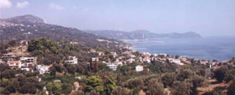
PEFKI (Port) EVIA
A village of astonishing natural beauty awaits the unsuspected visitor
just a few kilometres away from Athens.
Luxuriant vegetation, silver green olive groves, pine trees touching the surface
of the sea and long beaches compose a variable landscape, a colourful painting
of exquisite beauty.
It is the most developed resort of the municipality and the seaport
of the village Artemisio with
a good infrastructure in tourism.
Τhis text is cited May 2003 from the Municipality
of Artemissio tourist pamphlet.
POLYPOTAMOS (Village) KARYSTIA
Tel: +30 22240 51122
The village of Polypotamos is located exactly in the center of the
most narrow section of Evia (6 km. wide). The roofs of the houses are covered
in a type of tile which is abundant in the area.
This text is cited May 2003 from the Municipality
of Styra tourist pamphlet.

Receive our daily Newsletter with all the latest updates on the Greek Travel industry.
Subscribe now!