Listed 100 (total found 235) sub titles with search on: Main pages for wider area of: "STEREA HELLAS Region GREECE" .
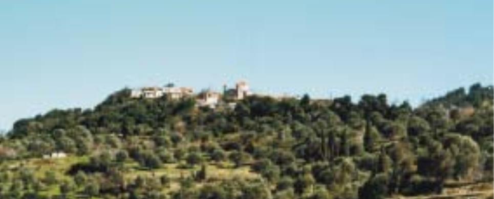
AGDINES (Village) ISTIEA
It is a village built in a thick forest of pine trees on a mountain.
The drive from the main cross-roads to the village is enjoyable even to the most
demanding visitor. Perennial plane trees, pine trees, flowing streams and the
Aegean Sea, which lies in
the background, leave the visitor speechless with astonishment. The region is
ideal for the fans of hiking.
Τhis text is cited May 2003 from the Municipality
of Artemissio tourist pamphlet.
AGIA EFTHYMIA (Village) PARNASSOS
Tel: +30 22650 67205, 67400
AGIA MARINA (Village) TITHOREA
Tel: +30 22340 71354
Agia Marina is between Kato
Tithorea and Tithorea,
a beautiful village with rich cultural and tectonic heritage. Visitors can sightsee
the Koimisis Theotokos Abbey where they can feel the awe and honor to all those
people who guarded Thermopiles.
They can also visit the famous platan at Agia Marina church and of course the
country church of Agios Nikolaos.
AGIA PARASKEVI (Settlement) EVRYTANIA

AGIA PARASKEVI (Village) LOKRIDA
A beautiful village at Fthiotida. Its park gives the visitor a different, calm
aspect of the agricultural life. There is also the famous monument of leon Haronia
at about 10 km away.
AGIA TRIADA (Village) EVRYTANIA
AGIANNAKOS (Settlement) CHALKIDA
A small agricultural colony, in about 5 km southerly of Rovies.
Its name is derived from the old church of Saint John (we find it in the 17th
century). Traces of ancient activities are found in this area.
This text is cited May 2003 from the Municipality of Elymnies tourist
pamphlet.
AGII PANTES (Village) PARNASSOS
Tel: +30 22660 81201
AGIOS GEORGIOS (Village) KARYSTIA
Tel: +30 22230 31054
AGIOS NIKOLAOS (Village) CHALKIDA
Tel: +30 22210 52326
The picturesque beach of Bourtzi got its name from the large fortress, built by the Venetians and used also by the Turks to control the straits of the Southern Evian Gulf, so that pirates could pass to and from Chalkida. The beach is not as popular for swimming as are the taverns which will give you a taste of fresh Evian, fish.
AGIOS VLASSIOS (Village) KARYSTIA
Tel: +30 22220 58603
AGRIOVOTANO (Village) ISTIEA
According to tradition its name stems from the weeds ("agriovotana")
growing in the region. Even though it covers a small area, it offers a spectacular
view. From the small square of the village the visitor can discern the mountain
Pilio and, weather permitting, even Athos. A passable dirt road leads from the
village to the beach "Koutsoubri" where there are picturesque taverns. The beach
is ideal for windsurfing and jet-skiing. The luxuriant vegetation and the long
beach compose a unique colourful scenery.
Τhis text is cited May 2003 from the Municipality
of Artemissio tourist pamphlet.
ALEPOCHORI (Village) DORIDA
Tel: +30 22660 41641
ALMYROPOTAMOS (Village) EVIA
Tel: +30 22230 53012
Fax: +30 22230 53816
Almyropotamos is the most notherly village of the Municipality
of Styra, located close to the border with the Municipality
of Dystos in an area of great interest. It has 500 residents and is set in
a rocky hillside in front of the valley which spreads out from the Dipotamo river.
The coastal hamlet of Panagia
belongs administratively to Almyropotamos, as does the islet of Kavalliani.
Many commentators identify Kavalliani as the ancient Glaukonissos, in the soil
of which the Olympic winner Glaukos, son of Dimilos, was buried by his fellow
Karystians.
The palaeontological survey in the valley of Almyropotamos has uncovered
many important finds which belong to mammals of the so-called Picermius fauna.
These are mainly the remains of small-bodied horses which were no higher than
1.30 metres tall and had three toes on each foot. According to specialists, Picermius
fauna belongs to a steppe environment and has an Asian origin; it is dated to
around 13 million years ago.
This text is cited May 2003 from the Municipality
of Styra tourist pamphlet.
AMARYNTHOS (Small town) CHALKIDA
AMBELOCHORI (Village) THIVES
Tel: +30 22620 25596
AMFIKLIA (Small town) LOKRIDA
Amfiklia is situated on the North East slope of Mountain Parnassos,
in the center of the mainland right next to the old state Road from Athens
to Thessaloniki, a bit further
south from the sources of Kifisos
river. It lies on the border line of three prefectures (countries) Fthiotida
- Viotia and Fokida
and is less than 50 km away from their capitals Lamia,
Livadeia and Amfissa respectively
- and some 170 km northwest of Athens. Amfiklia is situated between two distinctly
developed general areas of touristic interest. The coastal zone on the Euboean
Gulf (Gulf of Evoia island)
including Atalanti, Ag.
Konstantinos and Kammena Vourla
to the east and that which combines visits to the ski centers o Mt Parnassos and
the Delfi archaeological site as well as the St. Luckas Monastery and the seaside
towns (of Galaxidi and Itea)
on the Korinthian Gulf to
the west. Mt Parnassos is the mountain where guests will find the flora and fanua
from every part of the country concentrated at one place.
This text (extract) is cited November 2003 from the Municipality
of Amfiklia tourist pamphlet.
AMFISSA (Town) PARNASSOS
An ancient city, city state and home of the Esperian (western) Locris
with 70,000 people (according to the Greek traveller Pausanias - A.D. 180). It
owes its name either to the daughter of Makaros (son of Aiolos) Amfissa or to
a Greek verb "αμφιεννυμι" (=to surround-to dress with), because it is surrounded
by mountains. In 338 BC, during the Third Sacred War it was ruined by Phillip
II of Macedonia. In 30 BC the city was colonised by Aitolians and became very
populous. During the later Byzantine period it was renamed to Salona and at the
Middle Ages it was invaded by the Franks who established the Salona Barony (Salona
Barony - La-Sola, under the dynasty of Stromonkur).
At the 1821 Struggle for Freedom, it was the first city of Roumeli
to revolt under the leadership of Panourgias, Gouras and Isaiah, bishop of Salona.
On March 27 Panourgias invaded the city and on April 10th Salona Fortress was
invaded. Salona (Amfissa) became the capital of Eastern Terrestrial Greece following
the establishment of Salona Aeropagus,where the Resolution of Eastern Terrestrial
Greece Constitution was adopted.
Today, Amfissa is the capital of Fokida
department, numbering 12,000 inhabitants, centre of all Public Services. There
is a modern State Hospital, a Court of First Instance, a Cultural Centre, a Prison,
an Archaeological and a Cultural museum, a Public
Library with 40,000 volumes which is constantly enriched, City Band and Chorus,
Municipal Conservatory and Artistic Workshop, Cultural and Athletic Clubs. In
the city, there are also Technical Professional Institutions (Tourism Department),
Highschools, Primary Schools, Nurseries and other Educational and Professional
Institutions.Despite the passage of time, there still survive traditional manufactures:
Tanneries in the traditional neighbourhood of Harmena, bell and rope making industries.
Amfissa is well known for its notable cultural events (Fokika, carnival). The
visitors should visit the monuments of: The Annunciation Cathedral, the walls
of which areadorned with mural paintings of the famous painter Spiros Papaloukas,
the Salona Fortress (Orgia), the acropolis of Amfissa with ruins of all kind of
architectural styles.
Not far away, there is the "Sotiros" Church (Church of the
Saviour), a magnificent piece of art, a byzantine church (11th or 12th century).
At the base of Kofina hill, chiselled on cone shaped rock there is a Mycenaen
tomb, "the wolf layer", "Likotripa". Roman and Byzantine mosaics,
notably the Baptisery - 3rd or 4th century - and ruins of a basilica church. Finally,
in Amfissa there are many old mansions and neo-classic buildings adorned with
plaster decorations and beautiful wall paintings of local painters at the time.
Its inhabitants' main occupation is agriculture and namely the olive-trees.
The communities which along with the capital form the Municipality
of Amfissa are: Elaionas
(Topolia), a picturesque village with deep shade plane trees, with abundant spring
water, a magnificent cascade and vividness, Prosilio
(Segditsa), formed by three settlements, the old village, Biniani (the village
in the plain) and the beautiful resort with "Panagia" Monastery, where lived as
a monk for a while Kosmas Aitolos. At the site "lapsitsa" of Prosilio region
there is a forest village under construction, the 21wooden houses of which are
literally into the fir-trees forest, Drosochori
(Kolovata) the inhabitants of which moved to Amfissa, but it is re-constructed
as a magnificent resort, Agios
Georgios , Agios
Konstantinos and Sernikaki
, three adjoining picturesque villages lying at the west of the olive-trees plain
and, last, Agia Efthimia,
the village of Astrapogiannos and Giannis Skarimbas, built on the ruins of Ancient
Mionia.
This text is cited Sept 2003 from the WebPage
of the Prefecture of
Fokida
ANO KOUROUNI (Village) KARYSTIA
Tel: +30 22220 58969
ANO POTAMIA (Village) KYMI
Tel: +30 22220 71498
ANO VARDATES (Village) GORGOPOTAMOS
Tel: +30 22310 81462
ANO VATHIA (Village) CHALKIDA
Tel: +30 22290 36680
APOSTOLIAS (Village) PARNASSOS
Tel: +30 22650 91192
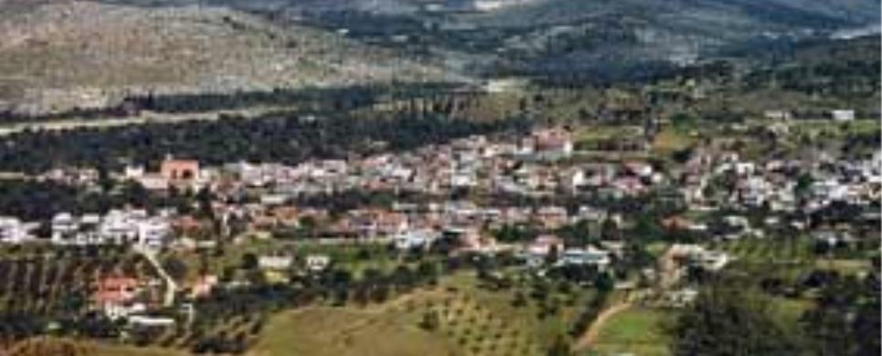
ARTEMISSIO (Village) ISTIEA
Artemissio is the main village in the Municipality of Artemissio.
The old name of the village was "Kourbatsi" (Turkish word which means thrashing).
In 1926 the village established a community independent of the Municipality of
Istiaia and was renamed Artemissio
in honour of the goddess Artemis whose temple was situated in the area of St.
George, where the cemetery of Pefki
is located today.
A tour of the village, where there are still houses dated from the
Turkish domination, is worthwhile. If you are fond of nature, you will enjoy walking
a little further from the village where there is a magnificent ravine full of
plane -, pine- and walnut-trees which will lead you to an area called "Agrilitsa".
The view is breathtaking, the eye can see as far as Mt Pelion
and the Sporades.
Τhis text is cited May 2003 from the Municipality
of Artemissio tourist pamphlet.
ARTOTINA (Village) DORIDA
Tel: +30 22660 51810
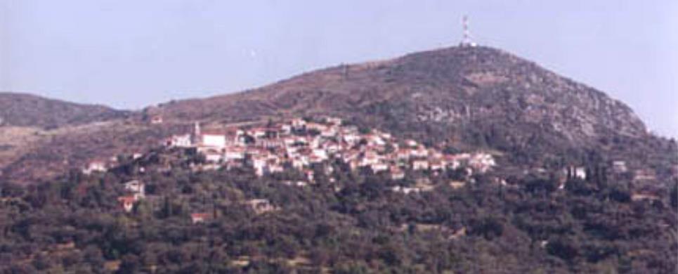
Artotina (1.300 m altitude) is the "capital of Vardoussia Mountains",
the biggest village of Dorida,
with its alpine landscapes. It is a place for the relaxation of the visitors,
as well as a place of revival of historic memory, because of Ai-Giannis Prodromos
historical monastery, where lived as a monk the 1821 hero Athanasios Diakos (his
cell remains intact), the bust of the hero of Alamana, the house of captain Andritsos
Siafakas, the memories of the struggle leaders of Artotina Skaltsodimos, Pistiolis,
Siafakas, Giannis Roukis, Gerantonou, Kaliakouda and others. There is a hostel
and a Folklore Museum.
Artotina and Athanasios
Diakos quarrel on which is the native village of Fokida's son and hero of
1821 Athanasios Diakos, each village presenting its own substantiation.
This exract is cited Sept 2003 from the WebPage
of the Prefecture of
Fokida
ASMINIO (Village) ISTIEA
Tel: +30 22260 41309
A modern village which maintains local colour. Its former name was
Potaki or Potoki (a word of Turkish origin) which means swampy area. It offers
comfortable accommodation and it is known for its nice ouzeris situated at the
central square. The village produces salted preserves of excellent quality.
It is worth visiting the church of Virgin Mary Dinious, 6km from the
village on the way to Istiaia, built in a magnificent landscape of plane trees
and flowing streams. The word "Dinious" is Turkish and means "return". According
to tradition, when a Turkish soldier fired the icon of Virgin Mary, the bullet
backfired and killed him. Her memory is celebrated on August 23 at a big fete
which attracts many natives as well as tourists.
Τhis text is cited May 2003 from the Municipality
of Artemissio tourist pamphlet.
ATHANASSIOS DIAKOS (Village) PARNASSOS
Tel: +30 22650 63216
AVLIDA BEACH (Small town) AVLIDA
Tel: +30 22210 31334
A coastal area in the South Evian Gulf with a 6km shore line. The waters are shallow and there are many taverns along the beach with local delicacies. The beach of Avlida is connected by coastal road to Dilesi, Chalkoutsi, Skala Oropou and, via Vathy, to the national highway Athens – Chalkida. Until 1927 the area was called Dramesi but since then it was recognized as the municipality of Avlida belonging to Evia Island, even though it is on the mainland. The story of the village starts in the prehistoric era, according to a few findings in the area. A local myth is that residents are decendents of Kadmos from Sparta. It was also a tourist resort in antiquity for the people of Thebes as it is now for the Athenians. In the 1991 census Paralia Avlidas had 2.473 residents but the population rises dramatically in the summer due to vacationers and can reach up to 15.000.Paralia Avlidas is a scenic place that has evolved into a resort with many vacation homes. Being close to Thebes that has an army training center, many of its residents are high ranking officers and the locals are mainly involved in agriculture and fishing.
CHALKIS (Ancient city) EVIA
Chalkida, the historic capital of Evia, is of particular archaeological
interest. It was flourishing during the classical and Hellenistic periods. However,
the archaeological finds, as well as written evidence, confirm that the town had
been inhabited much earlier and was already flourishing in the Early Geometrical
period (1100-750 B.C.) trading with the West and East.
There are three explanations for the derivation of its name: firstly
it took its name from the copper mines, secondly from Chalkida, the daughter of
Asopos or thirdly from "Chalki" or "Kalki", the purple shellfish which the Phoenicians
used for a dye in the town.
Descriptions of ancient visitors and historians gives us a picture
of a large thickly-wooded city with one of the most important markets in Greece,
colonnades round the market place, many temples, beautiful public buildings, gymnasiums,
theatres, stately homes and fortified walls with tall towers. The town had two
harbours and a bridge with two towers at each end, over the channel
of Evripus. A fortified enceinte surrounded the town and a second larger one
surrounded Kanithos and Evripus.
There was also an important wall with towers round the acropolis of Chalkida which
was situated on the hill Vathrovouni, south of the modern town. The successive
destruction of the town by its various conquerors and the natural disasters which
it suffered over the centuries and the fact that the modern city is built on the
ruins of the ancient town are the reasons why the recent archaeological findings
don't reveal fully the beauty and greatness of ancient Chalkida.
This text (extract) is cited May 2003 from the Prefecture
of Evia tourist pamphlet (1997).
CHRONIA (Settlement) CHALKIDA
Coastal colony of about 100 inhabitants, fishermen and farmers, situated
just westerly of Limni, on
the road Limni-Edipsos.
This colony was formed by Minor Asian refuges, after 1922, who found
refuge to the area of Limni.
Chronia is a small - pleasant resort for anyone who wants to spend
there his summer vacations, attracting a number of tourists during the summer
period.
This text is cited May 2003 from the Municipality of Elymnies tourist
pamphlet.
DAMIA (Settlement) CHALKIDA
It is a village on an altimeter of 300 meters and over, at about 6
km distance southerly of Rovies.
The available signs from very old times (the Stone Age) for people lived in the
area and the name itself of Damia leading to very old times, are information needing
to be detected. The life in the village seems to be assimilated, during the old
times, to the life of a wider area of Orovies and in post-byzantium times, to
the life the dominating existence of the Convent of Holy David - the old man.
The residents today deal with agricultural and veterinary works and the people
according to the census in 1991 are 76.
This text is cited May 2003 from the Municipality of Elymnies tourist
pamphlet.

DELFINO (Village) GORGOPOTAMOS
DELPHI (Small town) PARNASSOS
Delphi, with a population of 1.500, is one of the most beautiful and
impressing landscapes of Greece, and the centre -"omphalos "- of the world, according
to the ancient myth. It was already inhabited in the prehistoric times and later
-especially during the classic times- obtained great historic importance, as it
has been linked with the most significant events of Greek history. Apollo, the
God of catharsis and the genuine oracle, dominated earlier forms of worship in
the Delphi. He taught people
the "metron", that is prudence and modesty, which became the most ethical and
peaceful expression of the Greek spirit. The famous Oracle of Delphi, where the
god's divination was given through the mouth of Pythia, was directed by the so-called
priesthood, that is priests with deep mystic education. Moreover, Delphi with
the renowned Amphictyonic institution, gave the signal for friendship, brotherhood
and peaceful coexistence of peoples, as a fundamental goal of the Delphic idea
. A quite spectacular proof of the world-wide prestige enjoyed by the temple of
the God of Light was the amount of votive offerings by leaders, towns and rich
citizens, great in both quality and artistic value; unfortunately, very few of
them have survived through the time.
Today the visitor can admire various interesting architectural
monuments, as, in the northwest, one of the best preserved stadium of antiquity,
dating from the roman ages (a stadium had already been there since the 2nd half
of the 5th century BC). The stadium hosted the Pythian games, which were very
important in Greece and took place every four years. In the northeast, there is
the sacred place (temple), surrounded by a wall, contains, amongst other things,
the dorian Temple of Apollo (4th century BC), a theater for 5,000 spectators,
where in 1927 and in 1930 Aggelos and Eva Sikelianou organized for the first time
since antiquity ancient drama plays, as well as a set of Ηtreasures", small buildings
in the shape of a chapel, which various countries dedicated to the Sanctuary to
keep the precious offerings. The visitor can get an idea of these buildings by
visiting the erected Treasures of the Athenians.
The most important treasure appears to be the Treasure of Sifnioi,
especially for its sculpted decoration, exhibited in the Museum
of Delphi (one of the richest museums of the world), along with the magnificent,
unique copper statue of Iniohos, the Sphinx of Naxioi, the two young man statues,
findings of gold and ivory excavated in 1939 and tens of other findings. Eastward,
where the two rocks of Fedriads meet, we see the renowned Kastalia Spring, and
below the motorway, we see the Highschool and a little bit lower the Sanctuary
of Athena "Pronaia", within which we see the dome, a round structure of dorian
order, a true masterpiece. The new city of Delphi, which was transferred a km
wester, after the excavations in 1892, is characterized by a modern touristic
infrastructure and is ready to host all types of visitors. Here, we see the European
Cultural Center of Delphi which aims at reviving Delphi as a European and international
cultural centre with global activities, the house of Aggelos Sikelianos and his
wife, Eva, which has been transformed into the Museum of Delphi Celebrations,
a branch of the Arts School as well as many stores and workshops of folklore art.
(...)
This extract is cited Sept 2003 from the WebPage
of the Prefecture of
Fokida
DESFINA (Small town) PARNASSOS
At the foot of Kirfis mountain and at an altitude of 600m. is lying
amphitheatrically the small picturesque town of Desphina. Having a population
of about 2,500 inhabitants, nowadays Desphina is an independent Municipality,
near the site of the ancient city of Echedameia (there still are ruins-curved
graves, etc.), which was destryed by Phillip II of Macedonia (355-346 BC), native
town of the 1821 hero Isaiah bishop of Salona Isaiah and of the painter Spiros
Papaloukas.
Noteworthy monuments of Desphina and of the region are: the historic
monastery of Ag. Ioannis Prodromos related to the 1821 Liberation struggle, the
chapel of Taxiarches (in the yard of the Agios Charalambos church) which is a
Basilica built during the 12th century with notable but partly damaged wall paintings.
At the site Syro-Kastro there are still ruins of the ancient town of Medeon,
ruined together with Echedameia
by Phillip II (Third Sacred War).
This text is cited Sept 2003 from the WebPage
of the Prefecture of
Fokida
DICHORI (Village) VARDOUSSIA
DIONYSSOS (Village) ORCHOMENOS
Tel: +30 22610 32001
DROSSOCHORI (Village) PARNASSOS
Tel: +30 22650 23715
DRYMONA (Settlement) CHALKIDA
It is a mountainous village, situated at the northern "exit" of the
Convent of Holy David,
at an altimeter of 600 meters and over.
Drymona, the existence of which has been placed in the 16th century
and after, assimilated to the existence of the Convent of Old Man, is a nice fully
of forests village with a road leading to a little northern site where the waterfalls
of Sepia river, the most beautiful plateau the so called Microlivado (small meadow)
of Dry Mountain, and the
petrified forest of Kerassia
(district of Nilea Community).
The people living in Drymona are about 80, according to the recent
census of 1991.
This text is cited May 2003 from the Municipality of Elymnies tourist
pamphlet.

DYO VOUNA (Village) GORGOPOTAMOS
Tel: +30 22310 81770
EDIPSOS (Small town) EVIA
Edipsos did not suddenly spring up yesterday. It is, on the contrary,
steeped in history, with deep roots in the distant past. Tradition holds that
the Iones first settled here and named their new home "Ellopia" for Ellopos, the
son of Iona. It was later referred to as "Edepsos" in Aristotle's Meteorologica,
a toponym also inscribed on a stone found in Thessaly. Ploutarch described a very
pleasant stay in Edipsos with its lively social life and entertainment, praising
its fine cuisine of fish and fowl. Strabon wrote of the appearance of new springs
and their healing properties. From very early times Edipsos was, moreover famed
for its copper mines, perhaps one for the reasons it was one of the few towns
to mint its own coins. One of them appears as an illustration in Regas Fereo's
Charta. It bears the image of a crab on one side and a fish on the other, symbolizing
the abundant sea life of the area.
In Roman times Edipsos flourished due to its mineral waters and the
favour it found amongst the Roman elite. The emperors Hadrian, Septimus Severus
and Marcus Aurilius bathed in its waters. Other visitors included Gaius Pompeius,
Savinus, procosul of the Emperor Augustus and General Syllas. The best preserved
ruins from the Roman period are known as Sylla's Baths.
With the decline in Roman domination and the rise in Byzantium, Edipsos
was destroyed for being a center of paganism.
In more recent times, the cosmopolitan atmosphere of Edipsos drew
the attention of renowned politicians, artists, writers and jet-setters.
This text is cited May 2003 from the Municipality
of Edipsos tourist pamphlet (1999).

ELEFTHEROCHORI (Village) FTHIOTIDA
Tel: +30 22310 82188
ELLINIKA (Village) ISTIEA
The village is located on a slope of a hill covered with pine trees.
Its name has derived from the Greek ("ellinika") ships which anchored at the beach
before the naval battle of Artemissio.
Its beautiful beach is a real jewel, a harbour for small boats, with
pine trees along the sea. Across the beach there is a small island with the church
of St. Nikolaos. Swimming to the island is an opportunity to enjoy a workout.
Τhis text is cited May 2003 from the Municipality
of Artemissio tourist pamphlet.
ERATINI (Village) DORIDA
It is the capital of the new Municipality of Tolophon. It has a population
of 700 people and it is a beautiful small town near the sea, region's commercial
centre and an excellent resort.
ERETRIA (Municipality) CHALKIDA
Tel: +30 22293 50101
Fax: +30 22293 50150
ERETRIA (Ancient city) EVIA
Eretria is the second largest town in Evia
and was flourishing mainly during 800-700 B.C. and the classical period.
There are two possibilities for the derivation of its name: it may
come from the verb "ereso" which means "row" as the town had a strong navy, or
from the word arotro (plough) which became arotria and finally Eretria as the
inhabitants were landowners.
Many historians believe that the original location of Eretria was
on the hill of Xeropolis at Lefkandi
where archaeological remains have been found, until the end of the 8th century
B.C. when it was abandoned and transferred to the site of modern
Eretria.
This text (extract) is cited May 2003 from the Prefecture
of Evia tourist pamphlet (1997).
FOKIDA (Prefecture) STEREA HELLAS
FTEROLAKKA (Ski centre) PARNASSOS
The Ski Centre on Parnassos is situated at an altitude of about 1.600-2.300m and it is the biggest and best-organised ski-centre in our country.
The construction works at the Ski-Centre on Parnassos started in 1975 and were completed in 1976 just when facilities in Fterolaca started operating. It was in 1981 that construction works in Kellaria were completed whereas Hermes, the connection lift between Fterolaca and Kellaria was inaugurated in 1987-1988.
So far Parnassos has been Number one preference by the Athenians (since it is actually 180 kms far) as well as for other skiers and snowboarders who warm its tracks on weekdays but particularly during the weekend.
No wonder since the Centre has twenty tracks of 14 km total length. At the same time its infrastructure is such which facilitates quick service for a great number of visitors/skiers.
A further advantage of the Centre is the daily operation of all facilities
with lower price ticket.
This is due to the need for developing the adjoining Communities and Municipalities
and that's the reason why accomodation (Hotels) is not available at the area.
Its visitors can find an accomodation at the nearest villages or Municipalities which are about 20kms far from the Centre tracks.
The text has been cited in February 2005 from the following webpage of Parnassos Ski Centre.
GALAXIDI (Small town) PARNASSOS
Noble, picturesque, it stands proudly at the west part of Crisaean
Gulf, the historic Galaxidi with 1,400 inhabitants built on the site of the ancient
town of Oianthi (or Halaion
according to others), it is a nautical city that carries a heritage of 4,000 years
and which reached a peak during the 1821 Liberation War. Many invaders tried to
conquer Galaxidi during its history, such as Franks, Catalans, Knights of Rhodes,
Turkish pirates. But the city resisted and nowadays it is one of the most attracting
Greek resorts. Its sailing vessels travelled across the seas prior to the appearance
of of the coastal navigation. It was the first nautical force.
Some of the interesting monuments someone could visit: Agios Nikolaos
Church with the splendid and unique wooden temple, ruins of the walls etc. of
the Ancient Town and carved graves of the classic period, in the region of "Kalafati".
A traveller - tourist could also visit the Nautical and Archaeological
Museum, the Folklore Art Museum, the church of Agia Paraskevi with its sundial,
the Byzantine Monastery
of Saviour built around AD 1,250, the house of the great history researcher
Ί. Satha, the Tourism Department, the old Girls' School (Parthenagogeio), Chirolaka,
the old stone reservoir of 15th century, could admire the traditional houses and
buildings, among which the most important are: Tsalaggira Building (nowadays Municipality
Offices), Aggeli Building (nowadays Folklore Museum), Bourzeiko Building, enjoy
the sea on the superb beaches of the region, such as Kalafati beach, which, recently,
has been remodelled, and taste the local seafood at Galaxidi's restaurants.
This extract is cited Sept 2003 from the WebPage
of the Prefecture of
Fokida
GERAKIOU (Village) ISTIEA
It is a village on a slope of a mountain situated only 4 km away from
Pefki in a thick forest of plane
and pine trees. Creeks pouring down in a waterfall at the entrance of the village
complete the scenery. The village was given its name due to the numerous nests
of falcons (the Greek word for falcon is "geraki") in the area. The people are
mainly engaged in the exploitation of forestal resources.
Τhis text is cited May 2003 from the Municipality
of Artemissio tourist pamphlet.
GORGOPOTAMOS (Village) FTHIOTIDA
GOUVES (Village) EVIA
Tel: +30 22260 41435
A traditional village built on two mountain slopes full of plane and
pine trees. During the Turkish domination the region belonged to the Turkish bey
Mohamed Ibrahim and his sister Haime Naile. In 1831 the Turks sold their land
to the Greeks Vaptistis Drossos and Alexandros Desyllas. In 1882 the land of the
community was transferred to its inhabitants. The only highschool in the Municipality
of Artemissio is situated in the village.
A tower, where the Greek poet George Drossinis lived, rises above
the village. The tower has been restored to accommodate a museum. On the beach
of the village the fortress of Metaxas, which served as a defense post during
the World War II, still remains. You can see the base of the cannons, the cook-house
and the watch tower.
Τhis text is cited May 2003 from the Municipality
of Artemissio tourist pamphlet.
GRAVIA (Village) PARNASSOS
A historic village with a population of about 1,050 inhabitants which
probably took its name pidginly from the neighbouring ancient town of Karphia.
It is the capital of the new Municipality and it is situated on the 33rd km of
Amfissa - Lamia
National Road. Gravia is famous for the historic battle given on 8th May 1821
by Androutsos and the other leaders of the struggle, who closed themselves in
the legendary-historic Inn along with the 120 fighters and other supporters in
the region and stopped Omer Vrionis, by cutting his way towards Salona and Peloponnese,
targetting to the suppression of the Revolution. On the site dominates the statue
of hero Odysseas and, reently, the historic Inn ("Hani") has been restored (It
was inaugurated by the President of Hellenic Republic, M. K. Stefanopoulos and
it is open to visitors). In a distance of 5 km to the South East, on the mountainsides
there is the monastery of the Assumption of Virgin Mary (or Panasari), a significant
monument, with a Byzantine church (with two domes), built in AD 1517.
This extract is cited Sept 2003 from the WebPage
of the Prefecture of
Fokida

HERAKLIA (Village) GORGOPOTAMOS
Tel: +30 22310 81520
ITEA (Town) FOKIDA
Itea, built in the background of the Crissaean Gulf extends together
with the neighbouring Kirra, along the coastline of the plain sharing the same
name, the Crissaean Plain and it is the south ending up of the famous landscape
of Delphi. Itea, a relatively
new city, since it was founded in 1830, it managed to become soon an important
commercial and transit centre due to a series of favourable circumstances. Nowadays,
its population is about 9.000 people. The access to the city is easy, either by
sea - it has a good port that serves the transport of both people and goods -
or by land, as it is connected to the big road axis of Greece. It constitutes
the way out to the sea not only for the Department - it is the port of Amfissa
and Delphi - but also for
the entire area of Central Greece. Its marine constructed according to the most
advanced specifications has an anchorage capacity of 250 vessels and it is a good
solution for vessel owners even from Attica.
On 17th September 1827, in the bay of Η°gkaliΘ- (embrace), where there
was a dock for vessels the so- called "Salona Dock", Frank Abney Hastings,
a warm philellene and admiral of the Greek nautical force, piloting the first
steam military ship in history, ΗKarteriaΘ, blew up the Turkish flagship and decimated
the Turkish fleet. The terrible naval battle, that ended before it began, was
almost bloodless for the Greek squadron and decisive for the Struggle of the Greek
people. It contributed substantially to the acceptance of the idea of forming
a state military fleet and marked the beginning of Greece's independence. Itea's
street planning is perfect, it follows the Hippodamean System of Road planning,
and gives city and its visitors the feeling of comfort and functionality. Squares
and alleys full of trees make city beautiful and visitors can enjoy a walk through
these, on the dock and on the beautiful green hill of Agioi Anargiri. The city
is able, with its physical presence, its infrastructure and a net of services,
to offer to its visitors a modern and comfortable accommodation. Its shape allows
the contact with the sea from two sides, with beaches where everyone can pass
a few hours of tranquillity and pleasure in the clear water and escape from everyday
life.
The "Trokantero" and "Maiami" beaches, honoured with "Blue Flags",
gather many bathers as well as "Nafsika" and "Evaggelistria" beaches.
The city has the capacity to receive and it receives big events, such as "Acropolis"
and "Olympion" rallies, swimming contests of international prestige,
congresses, etc.. Several events - sport events (basketball, swimming, bicycle
races, cultural events (Nautical Week, carnival, Itea koulouma, concerts, etc.)-
entertain the local people and visitors all around the year. Itea, a modern, active
city, invites visitors to have a comfortable accommodation, to relax and enjoy
magical nights with a view to the Corinthian
Gulf. Municipality of Itea comprises: Kirra,
a very ancient town. Its foundation is lost in the darkness of prehistory. Findings
from excavations reinstate the existence of a settlement since year 3.000 BC.
The tradition considers that Cretan merchants founded the city. The existence
of Kirra during the historic period - after 1100 BC - cannot be questioned and
it is stated as a rich and powerful city. It was the only point of access to the
Delphi and flourished as
the port of the sacred city.
In addition, its power allowed it to play essential and leading role
to the matters of Fokida (Phocis)
and of the entire region. It was surrounded will strong walls, it was decorated
with temples - of Apollo, Artemis, Leto - and immense statues, according to Pausanias.
It had integrated port facilities, shipyards and private buildings and reservoirs.
We do not know the end of Kirra.
It is said that it was ruined in AD 740 by a devastating earthquake that hit many
areas of the Balkans, even Constantinople.
At the area of the port there still is a partly ruined medieval tower that had
been possibly used as a lighthouse. Nowadays Kirra
and Itea form a unique residential
complex. Kirra's beaches are ideal for sea-sports, there is an organised beach
at "Vrachakia"- and it has many rooms for rent, cambing facilities and traditional
taverns with sea food Tritea
is situated at the north-west of Itea bay, at an altitude of 380 metres. It is
an ancient city which once was inhabited by Ozolians and Lokrians until 30 BC.
It was an area submitted to the Roman Governor of Achaia. Near to the ruins of
ancient Tritea , nowadays
is situated the new village, which in the past was known as Kolopetinitsa, a name
given due to a possible misunderstanding of Kalopetinitsa.
This text is cited Sept 2003 from the WebPage
of the Prefecture of
Fokida

ITI (Village) GORGOPOTAMOS
Tel: +30 22310 82688
KALAMOUDI (Settlement) CHALKIDA
It is a mountainous village, situated at the "entrance" of the Convent
of Holy David.
Kalamoudi is surrounded by signs of life during very old times, nevertheless,
in particular, in Byzantine and medieval times, we find it "fully vivid" in blossom.
Since the 16th century its history has been identified the history
of the Convent of Old Man.
The people leaving in Kalamoudi are about 50, according to the recent
census of 1991.
This text is cited May 2003 from the Municipality of Elymnies tourist
pamphlet.
KALIMERIANI (Village) KYMI
Tel: +30 22220 23222
Fax: +30 22220 23222
KALOCHORI-PANTICHI (Village) AVLIDA
Tel: +30 22210 32945
KARYSTOS (Town) EVIA
The capital of southern Evia, Karystos, is built on the southern part of the island on a cove and in the shadow of mount Ochi. It is a modern town, developed for tourism. Karystos is approximately 120 km southeast from Chalkida but with a ferry connection to the eastern coasts of Attica.
The area has wonderful beaches and picturesque villages on mount Ochi, combining both sea and mountain. It can be the base for enticing tours to beaches or the mountain villages of Cavo D’Oro, in the Dimosari canyon.
The text was published on May 2003 in a brochure of Regional Division of Evia.
KASTANIOTISSA (Village) ISTIEA
KASTRIOTISSA (Village) PARNASSOS
Tel: +30 22650 62363
KATO TITHOREA (Small town) FTHIOTIDA
Kato Tithorea was and still is the financial, commercial, educational
and transporting center of the greater region. The railway station comes about
an important role. Tithorea is only 1h ½ away from Athens.
Tithorea, or Kalivia or Kiffisoxori, as it is also called, is a town
with ancient history. Nowadays Tithorea is a modern town where visitors can meet
the park of Agios Dimitrios, the old stone bridge of Magoulas, the Holy Temple
of Agios Haralampos, the park of Agia
Paraskevi and finally enjoy hospitality and food at the traditional tavernas
of the region. Parnassos
offers hospitality and safety to visitors.
KECHRIES (Village) CHALKIDA
Tel: +30 22270 92400
Kechries could be characterized as a junction connecting the eastern
with the western coasts of Evia, establishing, thus, ideal conditions for anyone
who wishes to spend his vacations there, combining the green forests of the village
with the freedom of choice among the coasts of Aegean or Evoic Seas.
Traditions and legends have combined the history of the small fountain,
found in the situation where the medieval village, so called Ligdia, and the passing
from there of the legendary knight, Erotocritos.
The area, which during the times of Turkish occupation was a Kara-Ali's
estate, was assigned, after the liberation, to the hands of the resolution fighter,
Angelos Tombazis. Then, after a decision of the Greek Government in 1925 it was
assigned to the landless farmers of the area.
Similar but at the same time, parallel to the history of Kechries,
is also the history of Daphne co-existing with the village of Kechries. It should
be noticed that in old times Daphne
was called "Mantanika" originated from the word "mantani" probably meaning the
high production.
This text is cited May 2003 from the Municipality
of Elymnies tourist pamphlet.

Receive our daily Newsletter with all the latest updates on the Greek Travel industry.
Subscribe now!