Western Achaia is one of the most beautiful parts of the Greek land.
The visitor will be stunned by the sudden scenery changes, the exquisite sandy
beaches, as well as the popular resorts on the slopes of
Erymanthos
and
Panahaikos.
Kato Achaia is the most important commercial and intellectual centre
of the area. According to historians, in antiquity this must have been the territory
of the
city of Dyme, a member
of the Achaean Confederation. Its residents had participated in all national contests
and they had developed a remarkable civilization while keeping the name of Achaia,
which, according to Homer, was the first name of
Greece.
Araxos airport,
which is the only place in
Achaia
where an airplane can land on is not far from Kato Achaia.
Metohi
with a wonderful Museum of Natural History is also nearby.
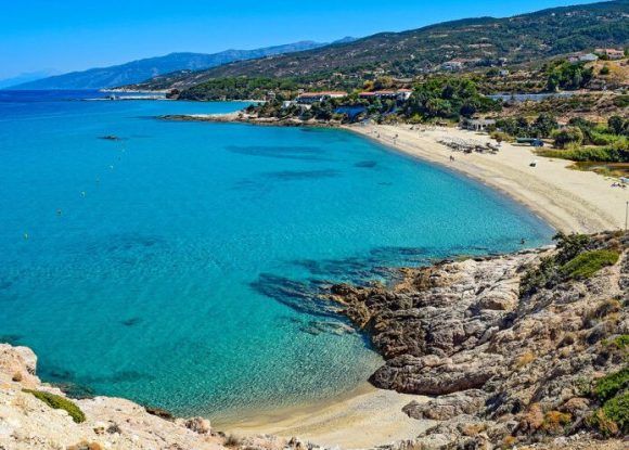
The golden beach of
Kalogria,
an endless sandy beach with sky blue water and an exotic atmosphere, together
with the pine forest of Strofylia, composes and idyllic landscape famous all round
Europe.
Pappas pond and the wetland of Prokopou consist a rare ecosystem of
unique beauty and great scientific interest. It is here where Teichos Dymaeon,
as well as many archaeological ruins, lie.
Along the coastal strip starting southwest of
Patras
and extending down to the western border of the Prefecture we meet on the waterfront
many scenic villages with significant tourist services. Such villages are
Vrahnaika,
Kato Alissos,
Niforeika,
Lakopetra,
Alikes,
a fishermen’s village and a Commune of the
Municipality
of Kato Achaia is not far form there either.
In the interior of Western Achaia, in the area of
Chalandritsa,
the excavations of 1928 brought into light burial grounds of the Mycenaean era.
Similar remains were discovered in the Community of
Portes
in 1995.
Katarrachtis,
Demesticha, and
Leontio
(where the ruins of an
ancient
city and a theatre of the 4th B.C. century are exposed) are three of the most
picturesque villages in the area, and so is
Michas,
which is set 1,100 m. above sea level. The whole are is situated right on the
site of
ancient Tritaea,
offers very good tourist services, as well as an amazing view. The surrounding
area of
Fares is equally remarkable
for its traditional communes and the obvious traces back to the time of Frankish
rule. In
Skiada the ancient
Tower of a Byzantine general, Doxapatri, has escaped destruction, whereas further
south lie the scanty ruins of the castle of Paleologos.
Sandameri
is the favourite area of parachutists who organize games of perpendicular and
vertical free-falling.
Last but not least, the monasterial cluster of
Movri
foothills (
Agios Nikolaos Spata,
Batha, Maritsa, and Filokali), which attract a large number of visitors, also
belong to Western Achaia.
This text (extract) is cited March 2004 from the Prefecture
of Achaia tourist pamphlet (1999).