Listed 81 sub titles with search on: Archaeological sites for wider area of: "ATTIKI Region GREECE" .
EGOSTHENA (Ancient fortress) ATTICA, WEST
In the Megarian sphere, Aigosthena was situated on the slopes of the
Kithairon in a deep inlet of the Gulf of Corinth, on the road between Boiotia
and the Peloponnesos.
Xenophon recorded the battles that took place here in 378 B.C. and
the presence of the army of Archidamos, and mentioned the inaccessibility of the
site (Hell. 5.4.18; 6.4.26). The fort is also mentioned by Pausanias (1.44.5).
Along with Megara, Aigosthena formed part of the Achaian League in 244, was then
ceded to Boiotia for a brief time, and re-entered the League after the second
Macedonian war. The interior circuit protecting the acropolis and the entire encircling
wall of the city are among the best examples of Greek military architecture. The
acropolis is to the E, defended by a mighty polygon of wall which is well preserved,
particularly on the E and NE sides. Eight large square towers in the wall served
as bulwarks. There was an entrance to the W and a rear entrance to the E. Each
tower consisted of two rooms and could be entered from the circuit wall by means
of a stairway. The N and S sides of the fortification walls extend, toward the
sea, into the two arms. Large square towers defend the curtain wall here also.
On the N side there are eight additional towers, while the wall and the towers
on the S side have mostly disappeared.
The whole fortification system is built of hard local limestone (a
quarry is identifiable inside the city walls) and in conglomerate rock, and shows
two different techniques. One is an irregular trapezoidal technique with a squared
face, datable to the 5th c.; the other is regular isodomic with the face perfectly
squared, datable to the 4th c. (several scholars, however, attribute the latter
to the beginning of the Hellenistic age). The few Roman constructions on the inside
of the city walls did not alter the fortifications.
Very few monumental remains have been discovered in the area of the
city. A small Byzantine church was built on an apsidal Early Christian basilica
(25.15 x 20.38 m) with three large aisles. Against the S side of the basilica
was a quadrangular baptistery.
N. Bonacasa, ed.
This text is from: The Princeton encyclopedia of classical sites,
Princeton University Press 1976. Cited Oct 2002 from
Perseus Project URL below, which contains 2 image(s), bibliography & interesting hyperlinks.
MEGARA (Ancient city) GREECE
The fountain was built in ca. 500 B.C. The front side of the building
was occupied by a portico with five Doric columns, and at the back of this was
a narrow cistern for the drawing up of water. Two more large cisterns, separated
by a parapet, were used for the collection of water. The roof was supported by
35 octagonal columns made of poros stone, while the walls were built of large
limestone blocks in the isodomic system.
The site of the spring was located in 1898 and partly uncovered in
1900. The excavation of the monument was carried out in 1957 and 1958 by J. Papademetriou.
After 1959, the water-tight plastering on the walls of the cisterns, was consolidated.
This text is cited Sept 2003 from the Hellenic Ministry of Culture URL below, which also contains image.
EGILA (Ancient city) ANTIKYTHIRA
In the innermost corner of the small bay of Xeropotamos, near the ancient fortress
of Aegila, some of the stones used to tie ships in the harbor remain. In 1880,
during excavations there, a marble statue dedicated to Apollo (now on display
in the Athens Archaeological
Museum) was discovered. On the base of the statue was an inscribed dedication
to the gods from Aristomenis, the son of Aristomides, a Thessalian from Ferres
and from Nikona, the son of Kifisodoros of Athens.
The same archaeologists found parts of a temple to Apollo that once stood there.
Round the ancient harbour, pieces of the wall that encircled the temple and the
harbour have survived, together with steps carved into the rock that led to the
castle.
This text is cited June 2005 from the Community of Antikythira URL below
VRAVRON (Ancient city) ATTICA, EAST
Lies beside a small bay on the E coast, about 38 km from Athens.
A fortified prehistoric settlement occupied the small hill about
400 m W of the bay, flourishing from the Neolithic to the Late Bronze Age, but
particularly during the period ca. 2000-1600 B.C. A few houses have been cleared,
and on the NW slopes of the hill E of the acropolis, several Late Helladic chamber
tombs were dug. This settlement was abandoned before the end of the Bronze Age,
and in the Classical period only a sanctuary remained. It lay just to the NW of
the acropolis and was active from the late 8th to the 3d c. B.C., when it was
destroyed by a flood of the nearby river Erasinos. The area was deserted in Roman
times, but in the 6th c. A.D. an Early Christian basilica was built about 500
m W of the sanctuary on the other side of the valley, and reused some material
from the sanctuary itself.
The goddess of the sanctuary, identified with Artemis, was particularly
connected with childbirth and was worshiped mainly by women. Her cult statue,
presumably a primitive one, was said to have been brought from the Crimea by Iphigeneia
and Orestes (Eur. IT 1462-67) but Pausanias (1.23.7; 1.33.1; 3.16.8) discounts
the story. Iphigeneia herself was supposed to be buried there. The special servants
of Artemis Brauronia were called arktoi (bears), young girls aged between five
and ten, who wore saffron robes, perhaps to recall the actual bearskins of an
earlier period (Suda, s.v. arktos e Brauroniois).
Greek excavations between 1948 and 1962 revealed the main buildings
of the sanctuary. Of the temple, dating from ca. 500 B.C., only the foundations
remain. It was a small Doric building (ca. 20 x 11 m), but little is known of
its plan. Immediately to the NW of the temple terrace is a copious spring into
whose waters offerings were thrown. From the partly artificial basin of the spring,
and from the bed of the stream flowing N from it, many dedications were recovered,
mostly of a feminine character--mirrors rings, gems, etc.; particularly valuable
are the objects of bone and wood which luckily have been preserved in the mud.
The spring seems to have been the most sacred part of the sanctuary until the
late 6th c. B.C., but both it and the temple were probably destroyed by the Persians
in 480.
About 10 m SE of the temple, in a cleft in the rock which was probably
once a cave, stood a small temple-like building which perhaps represents the supposed
Tomb of Iphigeneia. It seems to have replaced the earlier buildings to the SE,
which were destroyed by the collapse of the cave roof in the mid 5th c. B.C.
The most impressive building at the sanctuary is the large Doric
stoa dating from ca. 430-420 B.C., which was perhaps used by the arktoi. It was
to have had three colonnaded wings facing onto a court from the W, N, and E, the
temple terrace forming the fourth side. The E wing was longer than the W, and
did not have rooms behind its portico as did the N and W wings. In the end, the
N wing alone was completed; except for the column nearest the corner with the
N colonnade, the E and W colonnades never rose above their foundations. Behind
the N wing was a narrow courtyard with a small propylon at each end, and a shallow
portico forming its N side.
The N colonnade of the stoa has been partially restored, using the
original elements found lying in front of it. Its 11 Doric columns, with shafts
of local sandstone and capitals of Pentelic marble, stood on a marble stylobate,
which, although it has settled badly at the E end, seems to have been laid in
a rising curve like that of the Parthenon. The columns were more widely spaced
than in contemporary temples, so that above each span there are three metopes
instead of two; the spans nearest the corners were extended a further 12 cm to
allow a half-triglyph to appear in the frieze at the reentrant angle. The stoa
is one of the earliest buildings where this wider column spacing is found, and
where the problem of the reentrant angle had to be met; not surprisingly, therefore,
the adjustment of the column spacing is not really adequate.
Behind the N and (intended) W porticos of the stoa were various rooms,
the majority of them of a standard size (ca. 6 x 6 m) and equipped with 11 couches
and 7 small tables. The arrangement of these rooms is best seen at the E end of
the N wing, where the base blocks for several tables, as well as the holes where
couch legs were fixed with lead, still survive. The rooms were entered from the
porticos in front of them, and in the marble threshold of the first room from
the E can be seen one of the bronze pivots for the double doors and the prism-shaped
bronze projections that held the doors shut.
Besides the standard rooms, there were also in the N wing a narrow
passage to the N court, and a small room at the extreme W end, which probably
served as a lodge for the porter of the W gate into the N court. In the W wing,
the third room from the S formed the main entrance to the stoa and its court from
the W. The many wheel-marks visible here, however, belong with a rough road made
of reused reliefs and architectural members and laid over the remains of the stoa,
probably by people coming to remove building material from the site.
Along the central wall of the N wing, behind the rear wall of the
W wing, and at the foot of the N retaining wall of the temple, there were rows
of bases. On most of these bases were reliefs or inscriptions in honor of Artemis,
but there were also several statues of children, mostly girls (arktoi ?), dating
from the 5th and 4th c. B.C. Several fragments of the catalogue of dedications
to Artemis list separately the garments dedicated to the goddess, either in thanks
for successful childbirth or in memory of those who died as a result of it. The
garments were perhaps displayed on the racks which appear to have occupied the
narrow portico of the N court.
About 7 m W of the stoa, a bridge of the 5th c. B.C. crosses the
stream which flows N from the sacred spring to the Erasinos. It is ca. 9 m long
x 9 m wide, very simple in structure, and consists of horizontal slabs about 1
m long which rest on five rows of upright slabs. Not all the buildings at the
sanctuary have been uncovered; an inscription mentions several others, including
a palaistra and a gymnasium.
The finds from the excavations at the artemision are mostly housed
in a new museum on the site.
J. J. Coulton, ed.
This text is from: The Princeton encyclopedia of classical sites,
Princeton University Press 1976. Cited Oct 2002 from
Perseus Project URL below, which contains 8 image(s), bibliography & interesting hyperlinks.
Brauron. In a marshy valley on the eastern coast of Attica
lies the archaeological site of Brauron. Named after an ancient hero, Brauron
was one of the twelve cities of ancient Attica as well as the home territory
of the Athenian tyrant, Peisistratos. The river Erasinos flows nearby, making
this location suitable for the residential population it hosted for 2200 years
from the Neolithic through the Mycenaean periods. After abandonment in 1300
BC, Brauron saw no use until the 8th century BC, when it became the site of
the principal sanctuary of Artemis Brauronia. Legend has it that the priestess
Iphigeneia, on orders from Athena, established this cult at Brauron. The architectural
remains at the site include a small shrine, generally accepted as the Tomb of
Iphigeneia, a three-winged stoa, the temple of Artemis, and a stone bridge of
a style unique to Attica in its time.

Region: Attica
Periods: Geometric, Archaic, Classical, Hellenistic
Type: Sanctuary
Summary: Sanctuary of Artemis, worshipped in her function as protectress
of childbirth.
Physical Description:
On the coast ca. 38 km E of Athens, the sanctuary consists
of a cave and sacred spring and a court enclosed by a temple and a three-winged
stoa. The stoa housed the votive dedications and numerous dinning rooms. Inscriptions
mention other buildings including a palaestra and gymnasium which have not been
excavated. Ritual included dancing by "Arktoi," girls aged 5 to 10 dressed as
bears. Iphigeneia is said to have brought the cult statue of Artemis here and
to be buried here.
Description:
Earlier habitation and cemetery remains of Neolithic to
Late Bronze Age date have been found SE of the sanctuary, but the cult site appears
to date no earlier than the 8th century B.C. According to myth, the rites and
cult statue of Artemis (who was particularly connected with childbirth and was
worshipped chiefly by women) were brought to Attica from Scythia (Crimea) by Iphigeneia
and Orestes. The sacred spring at Brauron seems to have been originally the most
sacred part of the sanctuary, and the first temple was erected as late as ca.
500 B.C. Both were probably destroyed by the Persians in 480 B.C. when a wooden
image (perhaps the original cult statue) was reportedly carried off to Susa. About
10 m SE of the temple was a small building, perhaps representing the supposed
tomb of Iphigeneia. This seems to have replaced an earlier building to the SE
which was destroyed with the collapse of the sacred cave at mid 5th century. The
later stoa at the sanctuary had a number of dinning rooms perhaps used by the
Arktoi servant girls of Artemis Brauronia. Offerings (of feminine character) recovered
from the sanctuary, especially from the sacred spring, have helped to clarify
aspects of the cult. The site was finally abandoned after the nearby river Erasinos
flooded the sanctuary in the 3rd century B.C. There was no activity at the sanctuary
in the Roman period, but building material from it was reused in a 6th century
A.D. Christian basilica ca 500 m W of the sanctuary site.
Exploration:
Excavations: 1946-52 and 1956-63, J. Papadimitriou, Greek
Archaeological Society.
Donald R. Keller, ed.
This text is cited Oct 2002 from The Perseus Project URL below, which contains 8 image(s), bibliography & interesting hyperlinks.
Pages with photos by Kevin T. Glowacki, Assistant Professor in the Department of Classical Studies at Indiana University.
ARDITOS (Hill) ATHENS
It was originally a natural hollow part of the ground between the
two hills of Agra and Ardettos, over Ilissos river. It was transformed into a
stadium by Lykourgos in 330-329 BC for the athletic competitions of the Great
Panathinaea Festivities. Between 140 and 144 AD, Herodes Atticus restored the
Stadium, giving it the form that was found at the 1870 excavation: the horseshoe
construction with a track 204,07 meters long and 33,35 meters wide. It is believed
that the Stadium had a seating capacity of 50.000 people. Separating scales were
built between the tiers and on the base of the sphendone there was a portico with
Doric-style columns; another portico was placed in the stadium's facade. Herodes
possibly restored also the Ilissos river bridge on the Stadium's entrance, making
it larger and adding three archways on its base. The bridge was standing there
up to 1778 and a part of it was excavated in 1958. At the Roman times, the Stadium
was used as an arena, with the addition of a semi-circular wall on the north that
was corresponding to the sphendone of the southern side.
The modern times restoration of the Stadium was conducted by G. Averof
by the end of the 19th century for the first Olympic Games that were reborn again
in 1896.
This text is cited Sept 2003 from the Hellenic Ministry of Culture URL below, which also contains images.
LEMOS (City quarter) VOULIAGMENI
It is a significant historical symbol for the city, and is situated
in the hotel ASTIR area. The ticket you pay at the entrance, allows you also to
use the swimming pool. The temple's base is still standing, together with sections
of the peristyle and the altar which is dedicated to Leto and her twins, Artemis
and Apollo.
The discovery of the first archaelogical findings in 1952 started
when the children of the Vouliagmeni orphanage, while playing at the beach over
the ancient temple that was buried in the sand, found a piece of polished marble
with an inscription on it.
Detailed description of the temple:
The temple of Apollo Zostir is a temple of simple structure and moderate
size. The 'nave', i.e. the main section of the temple has dimensions of 10,8 m
X 6 m, and its entrance faces to the East.
In later years the temple aquired a 'peristasis', i.e. a kind of roofed
area around it, with the roof based on pillars. The 'peristasis', which is dated
at the second half of the 4th century bC, is comprised of 4 pillars at its two
narrow sides and 6 pillars at its wider ones. Today, only the bases of these pillars
are still remaining.
The floor of the temple is paved with perfectly aligned and fitted
together plates of titanolith.
Only the north side of the walls stil remains, at a height that is
less than 1 m. It is considered as the best existing specimen of the Archaic period,
and is constructed with the polygonic system, i.e. the stones are fitted together
only with the help of perfect hewing, rectangulation and setting, and without
any use of clay or lime. The archaeologists believe that the whole height of walls
of the temple were constructed in this way, in spite of the fact that during this
period, mud-bricks were used over a certain height.
During the Christian era the temple was converted into a small monastery,
which according to some researchers was dedicated to St. George, while others
believe that it was dedicated to Virgin Mary.
At the north-east side of the temple and at a distance of 6,5 m one
can see the base of the altar, constructed from big, othrogonized titanoliths
with dimensions of 4,25 X 2,55.
In the middle of the nave and aligned parallel to the entrance, three
bases of statues have been discovered. On the right and on the left were the statues
of Leto and Artemis, while in the middle stood the statue of Apollo. In front
of it there stood a solid, monolithic marble table of 1,10 X 0,62 and 0,63 high,
ending in two lion feet, of a rather sloppy craftmanship.
The fragments that were discovered in the temple lead the archaeologists
to believe that such tables, but of a smaller size, must have been present in
front of the other two staues, used as altars where the pious could lay down their
offerings.
The two pilasters of the entrance are also still standing, and the
two holes on the marble threshold seem to prove that the wooden gate of the temple
had two leafs.
This text is cited June 2005 from the Municipality of Vouliagmeni URL below
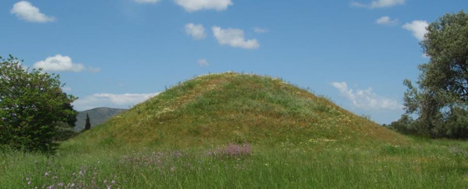
MARATHON (Ancient demos) ATTICA, EAST
Tel: +30 22940 55155
Fax: +30 22940 55155
The fertile plain of Marathon was a natural place for the establishment
and development of human activity from prehistoric to Roman times. Here on this
plain the battle between the Athenians and the Persians was fought in 490 B.C.
To this great event Marathon owes its worldwide fame and its important place in
the conscience of the ancient Greeks.
The
Mound was raised over the graves of the 192 Athenians who died in the battle
and whose remains were buried here after cremation of the dead.
The first excavations were carried out by D. Philios in 1884, and
subsequently by V. Stais in 1890 and 1891.
EGILA (Ancient city) ANTIKYTHIRA
The island's, ancient walled city, the "kastro" or stronghold
of ancient Aigila, lies in the north of the island above the above the bay of
Xeropotamos, once the city’s harbor. Its walls, which date from the Hellenistic
period, have survived in good condition. The city’s ruins cover about 75 acres,
and it probably had about 800-1000 inhabitants. Much of the fortification has
been preserved: in places, the walls stand as much as six meters tall. In the
harbour of Xeropotamos there is a neosoikos - an inclined space or slipway where
the warships from the pirate city were stored. It is carved out of the rock and
in exceptionally good condition; it is one of the few in Greece that have ever
been found preserved in their entirety. The ongoing excavation of the stronghold
has discovered that the fortifications were first built towards the end of the
fourth century BC or the begining of the third century BC. Important repairs were
made during the middle of the third century BC, after an expedition of invaders
from Rhodes devastated the city. It appears that from the begining the castle
was under the control of Falasarna, a well-known city of pirates in Western Crete,
which used it as an obeservatory and isolated outpost. The island's luck changed
between 69 and 67 BC, when the Romans the decided to embark on "an expedition
against piracy" and after the first century BC it seems to have been abandoned.
Throughout the city, archaeologists have found clear evidence of a long history
of war. The majority of the archaeological objects found are residues of war,
such as stone projectiles from small catapaults, arrowheads, and innumerable lead
sling-shots in the shape of almonds. The walls are marked by numerous and extensive
repairs, and in some places the repairs were clearly hasty and improvised.
This text is cited June 2005 from the Community of Antikythira URL below
ATHENS (Ancient city) GREECE
Site: Athens
Type: Altar
Summary: Altar enclosed in a peribolos wall; near the north end
of the Agora.
Date: ca. 522 B.C. - 425 B.C.
Period: Archaic/Classical
Plan:
Rectangular altar. Peribolos wall of stone posts and slabs supported by a poros
sill. Entrances on east and west.
History:
Identified by an inscribed marble statue base found in situ on west side of the
peribolos wall. Original altar was built in 522/21 B.C. by Peisistratos. Rebuilt
ca. 425 B.C. to repair damage suffered in the Persian invasion of 480/79 B.C.
The altar was used as the central point for measuring road distances. From the
5th century B.C., the altar became associated with the Goddess of Pity, probably
because the enclosed area served as a place of asylum. A round marble altar of
the 4th century B.C. may also have been in the sanctuary.
This text is cited Nov 2002 from The Perseus Project URL below, which contains 9 image(s), bibliography & interesting hyperlinks.
Site: Athens
Type: Hall
Summary: Large rectangular building; north of the Temple of Hephaistos
and Athena in the Agora, on the Kolonos Agoraios.
Date: ca. 320 B.C. - 280 B.C.
Period: Hellenistic
Plan:
Rectangular with buttressed walls, door opening east. Inside there were 2
rows of 8 supports forming 3 aisles. Large cisterns under the foundations held
run-off water from the roof.
History:
Probably used for storage, possibly of military equipment, thus the name "Arsenal."
Construction dated to late 4th or early 3rd century B.C.
This text is cited Nov 2002 from The Perseus Project URL below, which contains 1 image(s), bibliography & interesting hyperlinks.
Site: Athens
Type: Hall
Summary: Rectangular building; in the southeastern section of the
Agora, between the Middle Stoa to the north and the South Stoa II to the south.
Date: ca. 150 B.C.
Period: Hellenistic
Plan:
Rectangular. Stoa-like colonnade opened to the east. Five rooms lined the
west wall, all opening west at a lower level than the colonnaded hall. Middle
of the 5 rooms had steps and was a passage from the South Square to the colonnaded
hall. The 3 middle rooms may have had columns in antis. Southernmost room opened
west into the South Stoa II. The East Building was the eastern side of the area
known as the South Square.
This text is cited Nov 2002 from The Perseus Project URL below, which contains 1 image(s), bibliography & interesting hyperlinks.
Site: Athens
Type: Fountainhouse
Summary: Rectangular building; in the southeast corner of the Agora.
Date: ca. 530 B.C. - 520 B.C.
Period: Archaic
Plan:
Divided into 3 sections, a central large room with a rectangular basin at
its west end and a rectangular area at its east end where water could be taken
directly from a spout. Colonnaded entrance of 3 columns opening north.
History:
This building may have been the Enneakrounos, or nine-spouted fountainhouse,
built by the Peisistratids. On literary evidence Camp locates the Enneakrounos
south of the Acropolis, but agrees this is a fountain of the same period.
This text is cited Nov 2002 from The Perseus Project URL below, which contains 10 image(s), bibliography & interesting hyperlinks.
Site: Athens
Type: Statue Base
Summary: Rectangular statue base; in the Agora, 14 meters east of
the Metroon and roughly parallel to it.
Date: ca. 350 B.C.
Period: Late Classical
Plan:
Supported 10 bronze statues, and had tripods at either end. Surrounded by
a fence of stone posts and wooden rails.
History:
The Eponymous Heroes were the legendary heroes whose names identified the
10 tribes of Attica, into which the Attic population was officially grouped by
Kleisthenes in 508 B.C.
This text is cited Nov 2002 from The Perseus Project URL below, which contains 13 image(s), bibliography & interesting hyperlinks.
Site: Athens
Type: Altar
Summary: Ground altar; on the northern side of the Agora, to the
south of the Altar of the 12 Gods.
Date: ca. 525 B.C. - 500 B.C.
Period: Archaic
Plan:
Area bounded by a stone curb, surrounded by a paved area enclosed by a wall.
History:
This type of altar was often associated with a particular hero. May have served
as a shrine to the Aeginetan hero Aiakos.
This text is cited Nov 2002 from The Perseus Project URL below, which contains 1 image(s), bibliography & interesting hyperlinks.
Site: Athens
Type: Court
Summary: Large square enclosure; in the southwest corner of the
Agora.
Date: ca. 550 B.C.
Period: Archaic
Plan:
Originally no internal divisions or rooms and no roof. Opening on the north
side. Possibly a later inner colonnade and rooms.
History:
Originally the enclosure may have been a simple fence or rope. Early 5th century
B.C. the boundary was changed to a stone wall, and small rooms, probably offices,
were added on the south side, but the meeting place remaining unroofed. The Heliaia
was the name of the largest court in Athens and this building was of appropriate
size, date and type for its meetings, but the identification remains tentative.
Travlos has suggested it was a precinct of Theseus, but the votives commonly excavated
in such sanctuaries have not been found here.
This text is cited Nov 2002 from The Perseus Project URL below, which contains 4 image(s), bibliography & interesting hyperlinks.
Site: Athens
Type: House
Summary: Irregularly shaped building; just southwest of the Agora,
and west of the Triangular Shrine.
Date: ca. 475 B.C. - 275 B.C.
Period: Late Clas./Hell.
Plan: A complex of several rooms. Two cisterns in the largest room.
History:
The house is referred to as the House of the Marbleworkers Mikion and Menon
and was in use from 475 to 275 B.C. A bone tool inscribed with the name Mikion,
ca. 475 B.C., and pottery dating to ca. 275 B.C. bearing the name Menon, were
all found at this location. Excavation has revealed tools, marble dust and unfinished
sculpture, supporting the belief that this area, just to the southwest of the
Agora, was a location for marble working.
This text is cited Nov 2002 from The Perseus Project URL below, which contains 12 image(s), bibliography & interesting hyperlinks.
Site: Athens
Type: Fountainhouse
Summary: L-shaped building; in the southwest corner of the Agora,
near the Heliaia.
Date: ca. 350 B.C. - 325 B.C.
Period: Late Classical
Plan:
From a small square courtyard one entered the L-shaped colonnaded porch. A
2nd interior L-shaped colonnade divided the building into 2 parts: the L-shaped
colonnaded porch and the L-shaped draw basin. Water was drawn from over a low
wall which filled the spaces between the columns.
This text is cited Nov 2002 from The Perseus Project URL below, which contains 1 image(s), bibliography & interesting hyperlinks.
Site: Athens
Type: Hall
Summary: Halls, complex of 3 buildings; all in the Agora, beneath
the Square Peristyle, beneath the Stoa of Attalos.
Date: ca. 420 B.C. - 380 B.C.
Period: Classical
Plan:
Group of 3 buildings around an open triangular space. Law court A, roofed colonnade;
Law court B, rectangular hall; and Law court C, a rectangular hall. The northernmost
building, Law court B, was a large rectangular hall with a door and 2 columned
portico on the south side. Sharing Law court B's eastern wall was Law court A,
an open colonnade of 11 columns opening south, with a door and 2 columned portico
opening off its north eastern corner. Across from these buildings and to the south
was Law court C, a rectangular Hall, probably opening north, with a line of basins
at ground level on its north side.
History:
The excavated finds in this area of the Agora indicate the buildings' use
as law courts. A ballot box containing dicasts' ballots was found near the eastern
end of Law court B. Also in the area were found bronze jurors' identification
tags, water clocks, juror payment tokens and other such court furnishings.
This text is cited Nov 2002 from The Perseus Project URL below, which contains 2 image(s), bibliography & interesting hyperlinks.
Site: Athens
Type: Court
Summary: Square roofed colonnade; in the Agora, beneath the Stoa
of Attalos.
Date: ca. 338 B.C. - 300 B.C.
Period: Hellenistic
Plan:
Walled square enclosure with entrances on east and west. Inner Doric colonnade
of 14 x 14 columns.
History:
Size and location would have made this an appropriate meeting place for the law
courts. Travlos dates this building to the time of Lykourgos, 338 - 326 B.C.,
and states the building was carefully constructed. Camp dates the building to
300 B.C. and considers its construction to have been "shoddy," with the west side
unfinished.
This text is cited Nov 2002 from The Perseus Project URL below, which contains 1 image(s), bibliography & interesting hyperlinks.
Site: Athens
Type: Peribolos Wall
Summary: Small shrine surrounded by a wall and associated with a
well to the north; in the northern part of the Agora, across from the south wing
of the Stoa Basileios.
Date: ca. 400 B.C.
Period: Classical
Plan:
An enclosing wall around an outcrop of native rock (a sacred area from earlier
times). There was originally a door, perhaps with rail barrier, in the northern
side of the wall.
History:
Named the Leokoreion after the daughters of Leos, who were sacrificed to save
the city from a terrible plague. Votives (5th century B.C.), such as loom weights
and jewelry, commonly associated with shrines of females were found here. Also
known as the Crossroads Enclosure, because the date of ca. 400 B.C makes this
shrine later than the Leokoreion of literature, which would have been in use in
the 6th century B.C. The Leokoreion had a prominent position in the Agora and
consequently was a noted landmark. Silted in by the 4th century B.C.
This text is cited Nov 2002 from The Perseus Project URL below, which contains 1 image(s), bibliography & interesting hyperlinks.
Site: Athens
Type: Metroon
Summary: Chambered building, with front colonnade; on the west side
of the Agora, north of the Tholos.
Date: ca. 150 B.C. - 125 B.C.
Period: Hellenistic
Plan:
Four chambered building. Outer front colonnade of 14 Ionic columns linking
the 4 chambers and opening to the Agora on the east. Southernmost chamber and
the 2nd chamber from the south were equal in size. Second chamber from the south
is believed to have been the Temple of the Mother of the Gods (Metroon) with a
pronaos distyle in antis. Next chamber was slightly larger than the previous 2.
Largest and northernmost chamber had a square inner colonnade of 12 columns with
2 others in antis at the entrance.
History:
Built over earlier Bouleuterion and earlier limestone foundations of Temple
of the Mother of the Gods. The distinct units of the later Metroon would have
accommodated the Sanctuary of the Mother of the Gods, a council house and state
record storage. building including a temple
This text is cited Nov 2002 from The Perseus Project URL below, which contains 45 image(s), bibliography & interesting hyperlinks.
Site: Athens
Type: Stoa
Summary: Stoa; approximately in the middle of the Agora and dividing
it into north and south areas.
Date: ca. 175 B.C. - 150 B.C.
Period: Hellenistic
Plan:
Doric, two-aisled stoa, completely surrounded by unfluted Doric columns. The
center colonnade of 23 columns, may have been Ionic, and the center columns may
have been connected by screens to divide the stoa into halves. The Middle Stoa
was the northern side of the area known as the South Square.
This text is cited Nov 2002 from The Perseus Project URL below, which contains 7 image(s), bibliography & interesting hyperlinks.
Site: Athens
Type: Mint
Summary: Large, square building; in the Agora, near the South Stoa
I and west of the Enneakrounos.
Date: ca. 400 B.C.
Period: Classical
Plan:
Northern half was a courtyard. Furnaces located in a large room on the southwest
corner. Two small rooms in the southeast corner were possibly used for storage.
History:
This building is identified on the basis of excavation finds which included
coins and blank coins (flans), industrial debris, and the remains of furnaces
and slag basins. In the 2nd century A.D., a temple and Nymphaion were built on
the ruins of the Mint, and later, ca. 1000 A.D., a Christian church was built,
which is still standing.
This text is cited Nov 2002 from The Perseus Project URL below, which contains 8 image(s), bibliography & interesting hyperlinks.
Site: Athens
Type: House
Summary: Irregular units sharing walls; on southern edge of the
Agora, north of the Areopagus.
Date: ca. 450 B.C.
Period: Early Classical
Plan:
Groups of rooms organized around a courtyard (each house organized in a different
fashion). The house forming the northeast corner is nearly square, with small
rooms around a rectangular court. A chamber on the east side of the court had
one column in its west opening forming a small portico. Large room on the south
was probably the main living area, with smaller rooms for storage, weaving and
other activities.
This text is cited Nov 2002 from The Perseus Project URL below, which contains 1 image(s), bibliography & interesting hyperlinks.
Site: Athens
Type: Prytanikon
Summary: Irregularly shaped building; on the west side of the Agora,
formed an architectural unit with the Old Bouleuterion.
Date: ca. 550 B.C. - 525 B.C.
Period: Archaic
Plan:
Many internal irregularly shaped divisions, grouped around a colonnaded court.
Two cooking pits on the north side.
History:
Also known as Building F, Camp postulates that it may have been a palace for
the Peisistratids. Because the later Tholos was located on the same spot as the
Prytanikon and included the same area in its enclosure, it has also been suggested
that this structure served as a state dining hall.
This text is cited Nov 2002 from The Perseus Project URL below, which contains 2 image(s), bibliography & interesting hyperlinks.
Site: Athens
Type: Stoa
Summary: Stoa; on the south side of the Agora, between the Heliaia
and the Enneakrounos (SE Fountainhouse).
Date: ca. 425 B.C. - 400 B.C.
Period: Classical
Plan:
Two-aisled stoa opening north, with a Doric outer colonnade, an inner
colonnade of unknown order, and 16 rooms lining the southern wall. One narrow
room, and 15 square rooms which served as dining rooms and places of relaxation.
May have had a 2nd story.
History:
The 15 rooms apparently were outfitted as dining rooms and may have been used
by the city officials who were fed at public expense. The building was in use
until ca. 150 B.C., when it was displaced by South Stoa II.
This text is cited Nov 2002 from The Perseus Project URL below, which contains 3 image(s), bibliography & interesting hyperlinks.
Site: Athens
Type: Stoa
Summary: Stoa; on the southern edge of the Agora, on the approximate
location of the South Stoa I, between the Heliaia, and the Middle Stoa.
Date: ca. 150 B.C.
Period: Hellenistic
Plan:
Doric single-aisled stoa opening north. On the north, 30 columns in antis;
walls on the south, west and east sides. East wall had door communicating with
southern end of the East Building. Off-center in the south wall was a small rectangular
niche, possibly an exedra or fountain. The South Stoa II was the southern side
of the area known as the South Square.
This text is cited Nov 2002 from The Perseus Project URL below, which contains 3 image(s), bibliography & interesting hyperlinks.
Site: Athens
Type: Prison
Summary: Almost rectangular building; just off the southwest corner
of the Agora.
Date: ca. 450 B.C.
Period: Classical
Plan:
A long hall that led back to a courtyard. Five almost square rooms off the
west side of the hall and 3 off the east side. At the northeast corner near the
entrance, was a group of 4 rooms, possibly with a 2nd story.
History:
The location of the building near the law courts, its plan of separate cells with
an easily guarded single entrance, and its provisions for bathing provide all
the necessities for an ancient prison. The excavation of a small statue of Socrates
and a quantity of medicine bottles, likely vessels for the poisons used to execute
prisoners, have led to the identification of this building as the State Prison,
where Socrates was executed in 399 B.C.
This text is cited Nov 2002 from The Perseus Project URL below, which contains 31 image(s), bibliography & interesting hyperlinks.
Site: Athens
Type: Stoa
Summary: Stoa; in the northeast corner of the Agora.
Date: ca. 525 B.C.
Period: Archaic
Plan:
Small two-aisled stoa opening east, 8 Doric columns in antis on the east, 4 Doric
interior columns.
History:
After construction ca. 525 B.C., much of the stoa was rebuilt in the 5th century,
probably to repair damage suffered in the Persian invasion of 480/79 B.C. Ca.
300 B.C., 2 small prostyle wings were added. The stoa is named for the office
of the king archon, who was responsible for many of the city's legal and religious
matters, and copies of the law codes were displayed in the building. Immediately
east of the building is the large, rectangular oath stone, 2.95 m x 0.95 m, where
council members took an oath to guard the laws of the city.
This text is cited Nov 2002 from The Perseus Project URL below, which contains 8 image(s), bibliography & interesting hyperlinks.
Site: Athens
Type: Stoa
Summary: Stoa with wings; the south boundary of the Sanctuary of
Artemis Brauronia, on the Acropolis, southeast of the Propylaia, west of the Chalkotheke.
Date: ca. 440 B.C. - 430 B.C.
Period: Classical
Plan:
Four-part building. Main stoa, one-aisled opening north, running nearly parallel
to the south wall of the Acropolis. Two small projecting wings on the west and
east ends, with doors opening north. Both wings had 2 engaged columns on the walls
which faced onto the sanctuary. There is slight evidence that later a small stoa
was added on the northeast side, opening west and extending the line formed by
the earlier eastern wing.
This text is cited Nov 2002 from The Perseus Project URL below, which contains 11 image(s), bibliography & interesting hyperlinks.
Site: Athens
Type: Stoa
Summary: Two-storied stoa; on the eastern side of the Agora.
Date: ca. 159 B.C. - 138 B.C.
Period: Hellenistic
Plan:
Doric lower outer colonnade, with Ionic lower inner colonnade. An upper outer
colonnade of Ionic double half-columns, and an upper inner colonnade with palm
capitals. Stairways to the 2nd story at each end of the stoa. Each story had 2
aisles and 21 rooms lining the western wall. The rooms of both stories were lighted
and vented through doorways and small windows on the back wall.
History:
Identified by a dedicatory inscription on the architrave as built by Attalos
II, ruler of Pergamon from 159 B.C. to 138 B.C. The building assumes particular
importance in the study of ancient monuments because the reconstruction of 1952
- 1956 replicates the original form.
This text is cited Nov 2002 from The Perseus Project URL below, which contains 31 image(s), bibliography & interesting hyperlinks.
Site: Athens
Type: Stoa
Summary: Two-aisled stoa; in the northwest corner of the Agora.
Date: ca. 425 B.C. - 410 B.C.
Period: Classical
Plan:
Doric exterior, Ionic interior with projecting wings at both ends. Opened
to the east.
History:
Dedicated to Zeus Eleutherios (Freedom), a cult founded after the Persian
War. It was unusual for a religious building to take the form of a stoa rather
than a temple, and considering its central location it is likely that the building
also served other civic purposes. Possibly one of the accomplishments of Mnesikles,
the architect of the Propylaia.
This text is cited Nov 2002 from The Perseus Project URL below, which contains 19 image(s), bibliography & interesting hyperlinks.
Site: Athens
Type: Stoa
Summary: Two-aisled stoa; on the north side of the Agora
Date: ca. 475 B.C. - 450 B.C.
Period: Early Classical
Plan:
Doric outer colonnade and an Ionic inner colonnade, opening south.
History:
The building was originally known as the Peisianaktios, from its builder Peisianax.
The name Poikile (Painted) is derived from its famous murals painted by artists
such as Polygnotos.
This text is cited Nov 2002 from The Perseus Project URL below, which contains 4 image(s), bibliography & interesting hyperlinks.
Site: Athens
Type: Temple
Summary: Temple, tetrastyle in antis; on the west side of the Agora
between the Stoa of Zeus (Eleutherios) and the Metroon.
Date: ca. 338 B.C. - 326 B.C.
Period: Hellenistic
Plan:
A rectangular cella with a pronaos of 4 columns in antis on the east. An adyton
projected from the north side and communicated with the cella. On the north, in
the L formed by the adyton and connected to the Temple of Apollo by a wall was
the small, slightly older Temple of Zeus Phratrios and Athena Phratria.
History:
Under this temple are the remains of a smaller, apsidal Temple of Apollo,
dated to the 6th century B.C. The earlier temple was probably destroyed by the
Persians in 480/79 B.C.
This text is cited Nov 2002 from The Perseus Project URL below, which contains 14 image(s), bibliography & interesting hyperlinks.
Site: Athens
Type: Temple
Summary: Peripteral temple; on the west side of the Agora, on the
Kolonos Agoraios.
Date: ca. 449 B.C. - 444 B.C.
Period: Classical
Plan:
Doric peripteral temple, 6 x 13 columns. Cella with a pronaos and an opisthodomos,
both distyle in antis. Interior with superimposed Doric colonnade along 3 of the
cella walls, but the original number of columns is uncertain.
History:
Usually referred to as the Hephaisteion, the building was previously called
the Theseion, a name still in common use. It has also been proposed that the temple
was dedicated to Eukleia (Artemis). The temple was richly decorated. Planting
pits dating from the 3rd century B.C. show that the temple grounds were fully
landscaped. In the 7th century A.D. it was converted to a Christian church.
This text is cited Nov 2002 from The Perseus Project URL below, which contains bibliography & interesting hyperlinks.
Site: Athens
Type: Temple
Summary: Small temple; on the west side of the Agora, between the
Stoa of Zeus (Eleutherios) and the Temple of Apollo Patroos.
Date: ca. 350 B.C. - 338 B.C.
Period: Late Classical
Plan:
Simple cella with small altar in front; joined by a small wall to the Temple
of Apollo Patroos and forming and architectural unit with it.
History:
The temple is dedicated to Zeus Phratrios and Athena Phratria. In the 2nd
century B.C. a small porch was added.
This text is cited Nov 2002 from The Perseus Project URL below, which contains bibliography & interesting hyperlinks.
Site: Athens
Type: Tholos
Summary: Circular building; on the west side of the Agora, south
of the Bouleuterion.
Date: ca. 465 B.C.
Period: Early Classical
Plan:
Circular building. Six interior columns for additional support of the roof.
On the north side was a small annex that served as a kitchen.
History:
Often called the Skias (a type of sun hat) because of its conical roof. The
Tholos served as a state dining room for the Prytaneis of the Boule (Council),
and is located on the ruins of the earlier Prytanikon.
This text is cited Nov 2002 from The Perseus Project URL below, which contains bibliography & interesting hyperlinks.
Site: Athens
Type: Peribolos Wall
Summary: Triangle-shaped open air sanctuary; located just outside
the southwest corner of the Agora.
Date: ca. 450 B.C. - 425 B.C.
Period: Classical
History:
The shrine may be dedicated to Hekate, whose sanctuaries are commonly found
at crossroads.
This text is cited Nov 2002 from The Perseus Project URL below, which contains 1 image(s), bibliography & interesting hyperlinks.
Site: Athens
Type: Well
Summary: Circular well surrounded by a curb; north of the Leokoreion
at the north end of the Agora.
Date: ca. 400 B.C.
Period: Classical
History:
The public well came into use about the same time as the Leokoreion was built
and may have been part of the shrine. It has also been associated with the Athenian
cavalry corps of the 3rd century B.C. due to lead tablets, each bearing the name
and description of a cavalry mount, found during excavation. Perhaps the Hipparcheion,
or office of the cavalry, was near here.
This text is cited Nov 2002 from The Perseus Project URL below, which contains 10 image(s), bibliography & interesting hyperlinks.
EGOSTHENA (Ancient fortress) ATTICA, WEST
Site: Aigosthena
Type: Fortification
Summary: Fortification wall with towers; a city at the northeastern
end of the Gulf of Corinth.
Date: ca. 450 B.C. - 275 B.C.
Period: Late Clas./Hell.
Plan:
Roughly rectangular area walled from shore to acropolis and divided into 2 sections,
the town with the acropolis citadel at its southeast end. The citadel has 4 towers
on its east side with a postern gate between the center 2 towers. The southeast
tower is known as Tower A. The citadel is separated from the town by an interior
wall with towers and gate. Walls extended on the north and south from the citadel
to the sea. In the north wall is a well-preserved two-storied tower and gate,
illustrated here.
History:
Probably built by Demetrios Poliorcetes.
This text is cited Nov 2002 from The Perseus Project URL below, which contains 2 image(s), bibliography & interesting hyperlinks.
ELEFSIS (Ancient city) ATTICA, WEST
Site: Eleusis
Type: Bouleuterion
Summary: Council building; on the southwest corner of the 4th century
B.C. wall of the Sanctuary of Demeter and Kore.
Date: ca. 400 B.C. - 300 B.C.
Period: Late Clas./Hell.
Plan:
Three main rooms, with semi-circular area in middle room.
History:
Probably 2 columns within the semi-circular area. Hellenistic building with successive
alterations through Roman times.
This text is cited Nov 2002 from The Perseus Project URL below, which contains 1 image(s), bibliography & interesting hyperlinks.
Site: Eleusis
Type: Altar
Summary: Ground altar; to the northeast outside the Sanctuary of
Demeter and Kore, near the northwest corner of the Temple of Artemis Propylaia
and Poseidon Pater.
Date: ca. 600 B.C.
Period: Archaic
Plan:
Wall enclosing a rectangular open space. Eschara was a brick-lined pit covered
with a metal grid.
History:
The pit was used to burn sacrifices and although the visible remains are Roman,
excavation has revealed 6th century B.C. remains at the same location.
This text is cited Nov 2002 from The Perseus Project URL below, which contains bibliography & interesting hyperlinks.
Site: Eleusis
Type: Fountainhouse Summary: Rectangular fountain; to the northeast
outside the Sanctuary of Demeter and Kore, south of the Temple of Artemis, Propylaia
and Poseidon Pater.
Date: ca. A.D. 50 - A.D. 200
Period: Roman
Plan:
Approached from the north by 3 steps into a U-shaped building with 6 columns.
This text is cited Nov 2002 from The Perseus Project URL below, which contains bibliography & interesting hyperlinks.
Site: Eleusis
Type: Gate
Summary: Gate building; northeastern gate to the Sanctuary of Demeter
and Kore.
Date: ca. A.D. 170 - A.D. 180
Period: Roman
Plan:
Doric hexastyle amphiprostyle building approached by 6 steps on the east. Continuing
from the east, an Ionic inner colonnade of 6 columns divided the building into
3 aisles. Beyond, was a cross wall pierced by 5 doorways. The central passage
between the columns and through the doors was wider than the side passages.
History:
Probably built by Marcus Aurelius on the same site as an earlier gate from the
time of Kimon. It copied the central form of the Mnesiklean Propylaia in Athens.
This text is cited Nov 2002 from The Perseus Project URL below, which contains bibliography & interesting hyperlinks.
Site: Eleusis
Type: House
Summary: Many roomed house; west and outside the Sanctuary of Demeter
and Kore, within the Precinct of the Hiera Oikia.
Date: ca. 700 B.C. - 600 B.C.
Period: Archaic
Plan:
Irregular shape with almost apsidal west end . Entrance in the center of the southern
wall to a long narrow room or court. Five rooms lined the northwestern wall.
History:
The Sacred House was probably dedicated to a hero, and though the building was
destroyed in the 7th century B.C., cult activity continued in the precinct.
This text is cited Nov 2002 from The Perseus Project URL below, which contains bibliography & interesting hyperlinks.
Site: Eleusis
Type: Peribolos Wall
Summary: Trapezoidal wall; enclosing an area west and outside the
Sanctuary of Demeter and Kore, surrounding the Hiera Oikia.
Date: ca. 600 B.C. - 500 B.C.
Period: Archaic
Plan:
Entrance in the northeast wall.
This text is cited Nov 2002 from The Perseus Project URL below, which contains 1 image(s), bibliography & interesting hyperlinks.
Site: Eleusis
Type: House
Summary: Many-roomed house; west of the Greater Propylon, in the
northeast section of the Sanctuary of Demeter and Kore.
Date: Unknown
Period: Roman
Plan:
Roman house with numerous rooms, surrounded by a wall of earlier date.
This text is cited Nov 2002 from The Perseus Project URL below, which contains 1 image(s), bibliography & interesting hyperlinks.
Site: Eleusis
Type: Silo
Summary: Storage silo; east of the Telesterion and within the Periclean
wall of the Sanctuary of Demeter and Kore.
Date: ca. 450 B.C. - 425 B.C.
Period: Classical
Plan:
Triangular building with 12 interior pillars arranged irregularly.
History:
Built by Pericles, also known as the Siroi. The first fruits of the harvest would
have been stored here.
This text is cited Nov 2002 from The Perseus Project URL below, which contains 1 image(s), bibliography & interesting hyperlinks.
Site: Eleusis
Type: Well
Summary: Circular well; near the eastern corner of the Greater Propylon.
Date: ca. 600 B.C. - 500 B.C.
Period: Archaic
History:
This is the well around which dances to Demeter and Kore were once performed,
hence the name meaning Well of the Fair Dances.
This text is cited Nov 2002 from The Perseus Project URL below, which contains 3 image(s), bibliography & interesting hyperlinks.
Site: Eleusis
Type: Gate
Summary: Gate building; proper entrance to the Sanctuary of Demeter
and Kore, south of the Greater Propylon.
Date: ca. 60 B.C. - 10 B.C.
Period: Roman
Plan:
Ionic attached columns along 2 parallel walls enclosing a passage. Antae extended
forward of the doors on the south. Two Corinthian columns supported roof of long
vestibule. Inner end divided into 3 by short walls, parallel to exterior walls.
Inner portico 2 Caryatids.
History:
This gate replaced an earlier Peisistratid gate at the same location.
This text is cited Nov 2002 from The Perseus Project URL below, which contains bibliography & interesting hyperlinks.
Site: Eleusis
Type: Silo
Summary: Oblong structure; west of the Greater Propylon, northwest
and the Lesser Propylon.
Date: ca. 550 B.C. - 510 B.C.
Period: Archaic
Plan:
Rectangular shape. Entrance in center of the southeast side facing the Lesser
Propylon.
This text is cited Nov 2002 from The Perseus Project URL below, which contains 1 image(s), bibliography & interesting hyperlinks.
Site: Eleusis
Type: Peribolos Wall
Summary: Triangular wall; in the Sanctuary of Demeter and Kore,
next to the Lesser Propylon, on its western side.
Date: ca. 400 B.C. - 300 B.C.
Period: Late Clas./Hell.
Plan:
Peribolos wall and small temple with cella and pronaos opening east.
History:
Sanctuary to Pluto-Hades, the wall encloses a cave through which Pluto brought
Kore back from the underworld. The small temple is ca. 328 B.C., displacing an
earlier one on the same location.
This text is cited Nov 2002 from The Perseus Project URL below, which contains 1 image(s), bibliography & interesting hyperlinks.
Site: Eleusis
Type: Prytaneion
Summary: Group of rooms; in the Sanctuary of Demeter and Kore, northwest
of the Greater Propylon.
Date: Unknown
Period: Roman
Plan:
Groups of rooms around courtyards, of varying size and all roughly rectangular.
History:
Served as housing for pilgrims to the sanctuary. The northwest corner is older
than the rest of the structure, dating ca. 475 B.C.
This text is cited Nov 2002 from The Perseus Project URL below, which contains 1 image(s), bibliography & interesting hyperlinks.
Site: Eleusis
Type: Temple
Summary: Small temple; in the Sanctuary of Demeter and Kore, on
a platform north of the Telesterion.
Date: Unknown
Period: Roman
Plan:
Cella opening southeast onto a pronaos with 4 columns in antis.
History:
May have been a temple to Sabina, wife of Hadrian.
This text is cited Nov 2002 from The Perseus Project URL below, which contains 1 image(s), bibliography & interesting hyperlinks.
Site: Eleusis
Type: Platform
Summary: Platform (with later tetrastyle in antis building), with
L-shaped stepped approach; in the Sanctuary of Demeter and Kore, south beyond
the Plutonian.
Date: Unknown
Plan:
Rectangular area with L-shaped stepped approach.
History:
In the inner sanctuary and overlooking the Sacred Way, the platform may have served
as a place to observe the beginning of the pageant. At its southern end, just
beyond the Unknown Treasury, was a high rock used for dedications.
This text is cited Nov 2002 from The Perseus Project URL below, which contains 1 image(s), bibliography & interesting hyperlinks.
Site: Eleusis
Type: Stoa
Summary: L-shaped stoa with rooms; northeast of the Greater Propylon,
outside the Sanctuary of Demeter and Kore, bounding east and west sides of a court.
Date: ca. A.D. 100 - A.D. 200
Period: Roman
Plan:
L-shaped stoa opening southeast and southwest. Northwestern wing had 12 columns,
6 rooms behind. Southeastern wing with 14 columns and open southern end.
This text is cited Nov 2002 from The Perseus Project URL below, which contains 2 image(s), bibliography & interesting hyperlinks.
Site: Eleusis
Type: Hall
Summary: Large, nearly square hall with many columns; in the Sanctuary
of Demeter and Kore, at the end of the paved Sacred Way.
Date: ca. 435 B.C. - 421 B.C.
Period: Classical
Plan:
Eight tiers of seats on 4 sides divided by openings for 2 entrances on each of
3 sides. A total of 42 superimposed columns arranged in a 6 x 7 pattern supported
the opaioned roof. Directly below the opaion was a rectangular chamber.
History:
Serving as the initiation Hall and Temple for the Eleusinian Mysteries, the Telesterion
was located on the same spot through many building enlargements. The interior
chamber housed the hiera (sacred objects) and was known as the Anaktoron (Palace).
In all renovations after the Archaic period this area remained unaltered. The
earliest building traces on the site are of a Mycenaean megaron opening east.
This was replaced by a Geometric building, and by Solon's time (ca. 600 B.C.)
a rectangular hall, probably columned, running southwest-northeast had been built
to accommodate a larger number of participants. The Anaktoron may have been separated
from the rest of the building. There were other additions under Peisistratos,
ca. 550-510 B.C., and Kimon, ca. 479-461 B.C. The Classical building (ca. 435
B.C.) by the architect Koroibos, was designed to hold large groups, up to 3000,
to witness the ceremonial proceedings. In the 4th century B.C. a colonnaded porch
was added to the southeastern side of the building and was known as the Stoa of
Philon.
This text is cited Nov 2002 from The Perseus Project URL below, which contains 15 image(s), bibliography & interesting hyperlinks.
Site: Eleusis
Type: Temple
Summary: Temple; in the Sanctuary of Demeter and Kore, on the northern
end of the terrace north above the Telesterion.
Date: Unknown
Period: Roman
Plan:
Distyle in antis cella opening southwest onto a pronaos with 6 columns in antis.
History:
May have been a temple to Faustina, wife of Antoninus Pius.
This text is cited Nov 2002 from The Perseus Project URL below, which contains bibliography & interesting hyperlinks.
Site: Eleusis
Type: Temple Summary: Amphiprostyle temple; outside the Sanctuary
of Demeter and Kore, in the courtyard northeast of the Greater Propylon.
Date: ca. A.D. 100 - A.D. 200
Period: Roman
Plan:
Cella opening southeast onto a pronaos. Four Doric columns at each end. Stepped
platform.
History:
This temple is dedicated to Artemis Propylaia and Poseidon Pater.
This text is cited Nov 2002 from The Perseus Project URL below, which contains bibliography & interesting hyperlinks.
Site: Eleusis
Type: Arch
Summary: Two arches of identical plan; outside the Sanctuary of
Demeter and Kore, in the southeastern and southwestern corners of the forecourt
outside the Greater Propylon.
Date: ca. A.D. 130 - A.D. 200
Period: Roman
Plan:
Copies of Hadrian's Arch in Athens. Single wide arch with 2nd story of columns
and entablature above. Corinthian columns on piers to either side of the arch
opening (front and rear).
History:
Built by Antoninus Pius: one marking the end of the road from the harbor, the
other the end of the road from Megara.
This text is cited Nov 2002 from The Perseus Project URL below, which contains 1 image(s), bibliography & interesting hyperlinks.
Site: Eleusis
Type: Treasury
Summary: Small temple-like building; in the Sanctuary of Demeter
and Kore, adjoining the southern end of the Stepped Platform.
Date: ca. 350 B.C.
Period: Late Classical
Plan:
Single cella opening east, possibly with interior dividing screen.
This text is cited Nov 2002 from The Perseus Project URL below, which contains bibliography & interesting hyperlinks.
INOI (Ancient demos) ATTIKI
Site: Oinoe
Type: Fortification
Summary: Rectangular fortification at the eastern end of the Mazi
plain in Northern Attica.
Date: ca. 450 B.C. - 300 B.C.
Period: Late Clas./Hell.
Plan:
Fortified wall with projecting towers. Towers on 4 corners, 1 tower between corners
on the east and west walls, 2 towers along the north wall.
History:
Only the north wall is well preserved. The southern boundary is uncertain. Also
known as the Myoupolis fort. The pottery, masonry and the location of the site
correspond to the known history of the fortified deme of Oinoe. Oinoe is known
to have been walled before 431 B.C. and served as an important outpost for the
Athenians until the latter phases of the Peloponnesian War. It apparently controlled
the roads from Boeotia through the Mazi plain, between Eleusis and Athens. The
limestone construction of the west wall could date ca. 420-380 B.C. The conglomerate
construction is no earlier than the 2nd half of the 4th century B.C. Black-glazed
pottery found inside the wall dates from the 2nd half of the 5th century B.C.
through the Hellenistic period.
This text is cited Nov 2002 from The Perseus Project URL below, which contains 20 image(s), bibliography & interesting hyperlinks.
PIRAEUS (Ancient city) GREECE
Site: Piraeus
Type: Shipshed
Summary: Stoa-like boathouse; several located on the shores of the
harbors at Piraeus.
Date: ca. 480 B.C. - 390 B.C.
Period: Classical
Plan:
Floors, with slotted slipways cut to accommodate trireme keels, that sloped and
descended into the water between rows of tall columns alternating with rows of
shorter columns. Parallel roofs supported by taller columns at the ridges and
the shorter columns at the valleys.
History:
Slipways cradled and protected the keel and undersides of ship when it was hauled
from the water.
This text is cited Nov 2002 from The Perseus Project URL below, which contains 3 image(s), bibliography & interesting hyperlinks.
Site: Piraeus
Type: Theater
Summary: Theater; west of the Zea harbor.
Date: ca. 200 B.C. - 100 B.C.
Period: Hellenistic
Plan:
Cavea with stone seats facing a stage building which extended the width of the
orchestra. Orchestra surrounded by a covered channel. Fourteen flights of steps
creating 13 kerkides at the level below the diazomata.
History:
Modeled after the Theater of Dionysos in Athens. Design and proportions matched
those of the theater in Athens.
This text is cited Nov 2002 from The Perseus Project URL below, which contains 2 image(s), bibliography & interesting hyperlinks.
VRAVRON (Ancient city) ATTICA, EAST
Site: Brauron
Type: Temple
Summary: Temple; on the northwest side of the acropolis, directly
south of the west wing of the stoa.
Date: ca. 500 B.C. - 450 B.C.
Period: Archaic/Classical
Plan:
On a stepped terrace. Cella opening east onto pronaos distyle in antis. An adyton
behind the cella. Two rows of 4 columns each in the cella.
History: Constructed to replace an earlier Archaic temple. A church now
stands on the probable location of the Artemis altar. On the slope below the northwest
corner of the Temple of Artemis was a Sacred Spring and pool, from which thousands
of dedications were excavated, most dating pre-480 B.C.
This text is cited Aug 2002 from The Perseus Project URL below, which contains 3 image(s), bibliography & interesting hyperlinks.
Site: Brauron
Type: Temple
Summary: Small building; located in a cleft in a rock on the southern
edge of the Sanctuary of Artemis.
Date: ca. 450 B.C.
Period: Classical
Plan:
Cella and pronaos opening northwest.
History:
The structure is associated with an earlier grave or cenotaph of Iphigeneia, probably
located in a sacred grotto or the complex of rooms to the south. In mythology
Iphigeneia was a daughter of Agamemnon, who became a priestess of Artemis.
This text is cited Aug 2002 from The Perseus Project URL below, which contains bibliography & interesting hyperlinks.
Site: Brauron
Type: Stoa
Summary: Narrow hall; on the north side of the Stoa at Artemision
in the Sanctuary of Artemis.
Date: ca. 410 B.C.
Period: Classical
Plan:
A long narrow hall with roofed stoa on north side and open paved court running
its length. Communicating with the Stoa at Artemision by a narrow passage on the
south and opening on the east and west through propyla each with one column in
antis and a double door.
History:
This stoa is tentatively identified as the parastas referred to in inscriptions.
Built as an addition to the Stoa at Artemision, its function is uncertain. Possibly
animal stalls or shelter for dedications. The court in front had numerous pedestals
to support statues and other dedications.
This text is cited Aug 2002 from The Perseus Project URL below, which contains bibliography & interesting hyperlinks.
Site: Brauron
Type: Stoa
Summary: Three-sided stoa; surrounding the northern end of
the Sanctuary of Artemis.
Date: ca. 425 B.C. - 416 B.C.
Period: Classical
Plan:
U-shaped stoa with 3 colonnaded wings framing the west, north, and east sides
of a central courtyard, opening onto the court. The east wing was longer than
the north and west wings. The north wing had 11 Doric columns and a passage leading
to a more northerly stoa or court (Parastas) with which it shared a wall. The
center room on the west wing was a gate. The north and west wings had dining rooms
behind their colonnades, 9 rooms in total, each containing 11 couches and 7 small
tables.
History:
East and west wings were never completed. The girls who served Artemis may have
been house in the west wing, and the stoa may have been referred to as the parthenon
after the residents. Papidimitriou does not restore dining rooms in the west wing.
This text is cited Aug 2002 from The Perseus Project URL below, which contains 7 image(s), bibliography & interesting hyperlinks.
Site: Brauron
Type: Bridge
Summary: Bridge; ca. 7 m west of the Stoa at Artemision, crossing
the stream flowing north to the Erasinos from the Sacred Spring.
Date: ca. 430 B.C.
Period: Classical
Plan:
Approximately square bridge of slabs placed horizontally across 5 rows of vertical
slabs.
This text is cited Aug 2002 from The Perseus Project URL below, which contains 1 image(s), bibliography & interesting hyperlinks.
ACHARNAI (Ancient demos) ACHARNES
Region: Attica
Periods: Classical
Type: Settlement
Summary: Attic deme site.
Physical Description:
Acharnai was the largest of the Attic deme sites and known
to have been located 60 stades from Athens. Although its exact position remains
uncertain, it is believed to have been S of Mt. Parnes, in the area of the modern
village of Menidi (where inscriptions with Acharnaian names have been found).
Ancient sources refer to sanctuaries of Apollo Argyieus and Herakles and a temple
of Ares and Athena Areia at the site, but no trace of these remains have been
found.
Description:
In 431 B.C. the Spartans under King Archidamos occupied
the site and used it as a base from which to ravage the Attic countryside. In
404 B.C. the forces of the Thirty Tyrants also used the deme site as a base.
Exploration:
Little exploration has been done.
Donald R. Keller, ed.
This text is cited Oct 2002 from The Perseus Project URL below, which contains 5 image(s), bibliography & interesting hyperlinks.
ATHENS (Ancient city) GREECE
Region: Attica
Periods: Neolithic, Early Bronze Age, Middle Bronze Age, Late Bronze
Age, Dark Age, Geometric, Archaic, Classical, Hellenistic, Roman, Byzantine, Modern
Type: Fortified city
Summary: Fortified city and center of a major city-state.
Physical Description:
Located in the center of a large plain, enclosed on all
but S side by mountains, Athens is ca. 7 km inland from its seaport at Piraeus.
The site has been continuously inhabited from Neolithic times to the present.
The plateau and the slopes of the Acropolis hill were the area of earliest settlement
and later became the religious center of the ancient city. S of the Acropolis,
in the Ilissos district, were many sanctuaries and athletic establishments. N
of the Acropolis is the Agora, the civic and social center of the ancient city
and N of the Agora is the Kerameikos (the potters' quarter), the Sacred Gate (opening
toward Eleusis) and, beyond the city walls, the cemetery. W of the Acropolis are
the hills of the Areopagus (site of the most ancient court of Athens), the Pnyx
(meeting place of the popular assembly), and the Hills of the Muses and the Nymphs.
The NW quarter of the city was occupied by artisans and tradesmen and farther
W the Long Walls linked Athens to the harbor city of Piraeus.
Description: The natural defenses of the Acropolis, with
fresh water springs at its base and a vista of the plain and distant coast, was
a focus for prehistoric settlement, and by the Late Bronze Age a Mycenaean citadel
occupied the summit. This citadel was one of the few Mycenaean centers to survive
the upheavals and destruction of the later 13th century B.C. and may have served
as a refuge for those fleeing other parts of the collapsing empire. According
to tradition, Theseus, the king of Athens at this time (or somewhat later) unified
the towns of Attica in the synoecism (amalgamation) and founded the first city-state
of Athens. Although the city does not seem to have had a circuit wall until the
6th century B.C. (when it was built by Solon or Peisistratos), the 13th century
citadel continued to serve the city and, in fact, these defenses were still in
use at the time of the Persian invasion in 480 B.C. The Acropolis began its transformation
into a purely religious area in 566 B.C. when Peisistratos instituted the festival
and games of the Great Panathenaia and the great ramp and 1st temples were built
on the Acropolis. Religious constructions, although interrupted by the Persian
invasion, continued from the 6th century through the Roman period. Numerous sanctuaries,
shrines and other buildings of religious character were established on the Acropolis
slopes (where prior to the 6th century, habitations, shops, and cemeteries had
been located). The Agora of Theseus' time was located on the NW slope of the Acropolis
while the later Agora of Solon was placed to the N of the Areopagus. In the mid
6th century the Agora shifted to its 3rd and final location. After the Persian
destruction of Athens and the Acropolis in 480 B.C., major rebuilding began under
the archonship of Themistocles. A new and much extended wall was built around
the city and the fortification of the Piraeus which had been initiated in 493
B.C. were completed. Under the rule of Pericles in the 5th century, the masterworks
of the classical age were created on the Acropolis, and in the lower city. The
Athenian city walls were destroyed by the Spartans in 404 B.C., but again rebuilt
by Konon in 394 B.C. In 86 B.C. the walls of Athens and Piraeus were demolished
by Sulla and the city remained unwalled until the time of Valerian (253-260 A.D.).
The new walls included the new city which had been built by Hadrian. Valerian
also re fortified the Acropolis. In spite of Valerian's fortifications of the
city, Athens suffered a devastation by the Herulians in 267 A.D. After the Herulian
destruction a smaller circuit wall (known as the Late Roman Wall) was built to
the N of the Acropolis. The outer ancient circuit wall was repaired in Justinian's
time and in use up to 1204 A.D. In 529 A.D. Justinian closed the internationally
famous philosophical schools of Athens, but it retained its reputation as an intellectual
center throughout the Byzantine period.
Exploration:
Excavations began after Independence in 1833 and continue
almost without interruption to the present under Greek and foreign auspices.
Donald R. Keller, ed.
This text is cited Oct 2002 from The Perseus Project URL below, which contains 671 image(s), bibliography & interesting hyperlinks.
EGINA (Ancient city) ATTIKI
Region: Saronic Gulf
Periods: Neolithic, Early Bronze Age, Middle Bronze Age, Late Bronze
Age, Dark Age, Geometric, Archaic, Classical, Hellenistic, Roman, Byzantine, Modern
Type: Fortified city
Summary: Capital city of the island of Aegina.
Physical Description:
The ancient capital of Aegina is located on the NW coast
of the island, partially under the modern town. The city had a larger commercial
harbor and N of this a rectangular military harbor. The latter was protected on
the N by a low promontory which served as the acropolis. The Classical city walls
enclosed both harbors and the acropolis promontory. On the promontory beneath
the levels of the ca. 500 B.C. temple of Apollo and the remains of an earlier
temple, excavations have uncovered levels of continuous occupation extending back
through the Bronze Ages to the Neolithic. The successive settlements on the acropolis
were each fortified, at least since the Early Bronze Age. The 6th century temple
of Apollo was replaced by a late Roman fortress.
Description:
Aegina is located in a key maritime position and since prehistoric
times has had close trade contact with the mainland and the islands. It may have
been depopulated in the Dark Ages and then resettled by colonists from the Peloponnese
in the 10th century B.C. By the end of the 8th century, however, Aegina was independent
of any mainland ties. During the 7th and 6th centuries, Aegina was a major maritime
power and had trade contacts from Egypt to Spain. The island was especially noted
for its fine pottery and bronze products. Aegina was apparently the first Greek
city state to adopt coinage and its system of weights became one of the earliest
standards for trade in the Greek historical period. During the 6th century B.C.
the growing power of Athens came into conflict with the interests of Aegina. Although
Aegina fought along side the Greeks at Salamis, conflict with Athens continued
and in 458 B.C. Athens defeated the combined navies of Aegina and Corinth. In
431 B.C. Athens expelled the inhabitants of Aegina and established an Athenian
cleruchy on their territory. In 404 B.C. the remaining Aegina citizens returned
from exile, but the city was no longer a major power. Aegina came under Macedonian
control and finally in 210 B.C. it passed to the rule of Pergamon.
Exploration:
Excavations: 1894, B. Stais; 1901, Thiersch; 1904, Keramopoullis.
German excavations directed by P. Wolters 1924-1926; by G. Welter 1926-1931, 1941-43;
and by H. Walter 1966-1972.
Donald R. Keller, ed.
This text is cited Oct 2002 from The Perseus Project URL below, which contains 36 image(s), bibliography & interesting hyperlinks.
EGOSTHENA (Ancient fortress) ATTICA, WEST
Region: Megarid
Periods: Geometric, Archaic, Classical, Hellenistic, Roman
Type: Fortified city
Summary: A Megarian fortified city.
Physical Description:
Aigosthena is at a sheltered bay at the E end of the Gulf of
Corinth. The site commanded the ancient route from Boeotia to the Peloponnese.
It was never of great importance in antiquity and was mentioned by only one ancient
writer, Xenophon in 378 B.C. It has not been excavated, but is considered one
of the best surviving examples of Classical Greek military architecture.
Description:
Although surface finds suggest occupation in the area from Geometric
to late Byzantine periods, the fortifications themselves belong to the 5th and
4th centuries B.C. Aigosthena belonged to Megara and formed part of the Achaean
League in 244 B.C., although it had been under the control of Boeotia for a short
time before the 2nd Macedonian War.
Donald R. Keller, ed.
This text is cited Oct 2002 from The Perseus Project URL below, which contains 37 image(s), bibliography & interesting hyperlinks.
ELEFSIS (Ancient city) ATTICA, WEST
Region: Attica
Periods: Middle Bronze Age, Late Bronze Age, Dark Age, Geometric,
Archaic, Classical, Hellenistic, Roman
Type: Sanctuary
Summary: Panhellenic sanctuary of Demeter and Kore and center for
the Eleusinian Mysteries.
Physical Description:
The city of Eleusis (birthplace of Aeschylus) is located
22 km W of Athens on a ridge above the bay of Eleusis and at the S side of a large
plain. The site has been occupied since the Early Bronze Age and the acropolis
fortified at least as early as the Late Bronze Age. The location commands the
land routes from Athens to the Peloponnese and NW Greece. The sanctuary of Demeter
is located within the city walls of Eleusis, occupying the area between the E
slope of the acropolis and the E fortification wall, and is isolated from the
rest of the city by a separate cross-wall at the NE. Within the sanctuary another
cross-wall, breached by the Lesser Propylaia divides the N area of the priests'
dwellings and administration buildings from the sacred inner peribolos. The main
architectural features of the inner sanctuary are the Kallichoron or sacred well,
the cave of Pluto adjacent to a triangular court and the Telesterion of Demeter
(an almost square building that could seat 3000) where the secret initiation rites
were completed and entrance to the uninitiated was forbidden on pain of death.
An anaktoron or separate shrine was maintained within the Telesterion. From the
outer sanctuary the Greater Propylaia opened onto the grand Sacred Way which joined
the sanctuary to Athens.
Description:
According to tradition, Mycenaean Eleusis was the home
of an early cult of Demeter and one of the 12 Attic cities to unite in the Synoecism
formed by Theseus of Athens. Although the association with Demeter is not definite,
remains of a Mycenaean shrine have indeed been found under the later sanctuary
of the goddess. In the Geometric period (at ca. 750 B.C.) the earliest Telesterion
(the building where the mysteries were conducted) was built. At ca. 600 B.C. a
larger Telesterion, known as the Solonian was built and the Eleusinian Mysteries
became a Panhellenic cult. In the 2nd half of the 6th century B.C., under the
influence of Peisistratos and his sons, the size of the sanctuary doubled and
new walls and an enlarged Telesterion were constructed. The Peisistratean Telesterion
was destroyed during the Persian War. Kimon initiated reconstruction in 470 B.C.,
but his plans were never completed. The new Telesterion was built during the Periklean
age in the 2nd half of the 5th century B.C. and the sanctuary became one of the
most renowned in Greece. The fame of the Mysteries spread beyond the Greek borders.
During the Peloponnesian War (431-404) the sanctuary was respected by the warring
states. In the 2nd half of the 4th century the sanctuary of Demeter and the city
of Eleusis increased in size to attain its greatest extend. The Roman Emperors
favored the sanctuary and the city of Eleusis. When the Kostovoks burned the Telesterion
of Perikles in 170 B.C., it was rebuilt and slightly enlarged by Marcus Aurelius.
Many Roman officials (including Hadrian in 125 A.D.) were initiated into the Mysteries.
The destruction of the sanctuary by the Visigoths in 396 A.D. and the anti-pagan
decree of Theodosius ca. 390 A.D. ended religious activity at the sanctuary.
Exploration:
G. Wheler reported on the site in 1676. In 1811 the Dilettanti
Society carried out the first excavation. The Greek Archaeological Society has
excavated from 1882 to present.
Donald R. Keller, ed.
This text is cited Oct 2002 from The Perseus Project URL below, which contains 47 image(s), bibliography & interesting hyperlinks.
PIRAEUS (Ancient city) GREECE
Region: Attica
Periods: Archaic, Classical, Hellenistic, Roman
Type: Port city
Summary: Port located on the Munichia peninsula 7 km from Athens.
Physical Description:
The 3 natural harbors (Zea and Munichia on the E and Kantharos
on the W) of the peninsula were enhanced with fortified moles and narrowed entrances
that could be closed by chains. The peninsula was enclosed by fortifications and
3 long walls provided a secure corridor to Athens. Piraeus was laid out and built
on a grid plan by Hippodamos of Miletus. In addition to a spacious agora at the
center of the city and numerous public and religious buildings, many quays, warehouses,
arsenals, dry docks and over 300 ship-sheds served the Athenian fleet and commercial
interests. A majority of the inhabitants were "Metics" or resident aliens which
gave the city a cosmopolitan character.
Description:
Prior to the 5th century B.C., the Athenians kept their
warships at the beach of Phaleron Bay, E of the Munichia peninsula. As Athens
grew to rival the major maritime powers of Corinth and Aegina, Themistocles created
an Athenian fleet of 200 ships and in 493 expanded the fortifications of the Piraeus
which Hippias had started in 527-510 B.C. In addition to the fortifications, ship
sheds, dry docks, storage buildings, and arsenals were built to serve as base
for the fleet. After the interruption of the Persian invasion in 480 B.C., the
work continued and at ca. 450 B.C. the architect Hippodamos of Miletus laid out
a new city grid plan (one of the earliest employment of this plan in Greece),
and the Long Walls to Athens were constructed. The Long Walls and fortifications
were destroyed on order of the Spartans at the end of the Peloponnese War in 404
B.C., but rebuilt by Konon in 393 B.C. Piraeus was pillaged by Sulla in 86 B.C.,
but enjoyed a revival under Hadrian and the Antonines in the 2nd century A.D.
In 267 A.D. the city was raided by the Herulians, and after another destruction
by Alaric in 396 A.D. it lost its importance as a major port city.
Exploration:
1885 excavation gave plan of ship-sheds. 1887, French School
of Archaeology excavated the Aphrodision Gate. Little systematic excavation, but
many chance finds and salvage digs by the Greek Archaeological Service.
Donald R. Keller, ed.
This text is cited Oct 2002 from The Perseus Project URL below, which contains 54 image(s), bibliography & interesting hyperlinks.

Receive our daily Newsletter with all the latest updates on the Greek Travel industry.
Subscribe now!

